Category Archives: semi-arid

Highly resilient response at a Cooma restoration site points to native plant adaptation to drought and short growing seasons

Tein McDonald

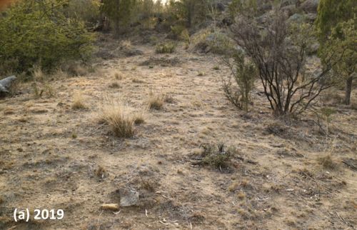
Figure 1. One of the many ‘before and after’ photo pairs showing how, (a) at the start of the project in 2019, a near-monoculture of African Love Grass was persisting even during the drought – but (b) native regeneration boomed after two seasons of good rain and regular spot-spraying of the prolific and diverse weed that regenerated along with the natives.

Introduction. Assisted regeneration works have been undertaken over three seasons at a small (4ha) but uncleared privately owned bush block on the urban boundary of Cooma in the southern tablelands of NSW. Degradation at the start of the project in 2019 reflected past land uses. Flatter areas disturbed by historic light sheep grazing and vehicular tracks appeared in poor condition, with infestations of serious weed, particularly bird spread shrubs and pasture weeds. Drought-induced dieback occurred across the site, along with evidence of overgrazing by macropods and rabbits. Most of the site’s extensive (lichen and moss-covered) granite rocky knolls, however, remained undisturbed and in good condition.

Results of the works were expected to be gradual, given that the area’s annual average rainfall was around 538 mm and growing seasons short due to the southern tablelands’ relatively cold climate. While these lower expectations were reasonable, they did not factor in the above average rainfall of the 2021-21 season and, particularly, the very high and evenly distributed rainfall of the 2021-22 growing season.

Vegetation community. The main vegetation association on the site (and the Reserve) is Ribbon Gum (Eucalyptus viminalis)-E Black Cypress Pine (Callitris endlicheri) grassy woodland, with co-dominant trees including Candlebark (E. rubida), Apple Box (E. bridgesiana), Broad-leaved Peppermint (E. dives) and Mountain Gum (E. dalympleana). Sweet Bursaria (Bursaria spinosa), Red-stemmed Wattle (Acacia rubida) and Woolly Grevillea (Grevillea lanigera) are common in the mid-storey, along with six Fabaceae shrubs. Out of the 88 native vascular plant species, 63 are herbaceous (15 grass species and 48 forb species including 13 Asteraceae) species.

Weeds. At least 40 weed species occur on site, falling into two groupings – shrubs and groundcovers. The most prevalent shrubs were Orange Firethorn (Pyrocantha spp.) and Cotoneaster (Cotoneaster spp.) The most prevalent groundcovers were African Love Grass (Eragrostis curvula), Yellow Catsear (Hypochaeris radicata), Smooth Catsear (Hypochaeris glabra), St Johns Wort (Hypericum perforatum), Hare’s Foot Clover (Trifolium arvense), Proliferous pink (Petrorhagia nanteuilii) and Fleabane (Conyza sp.).

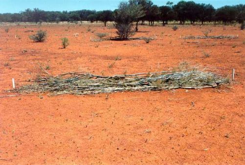
Works undertaken. Works have focused on the systematic and careful spot-spraying of individual weeds, rigorously following up to avoid the weed recharging soil seed banks. Cut brush was also laid down in a brickwork pattern along the contours to retain waterflow (where erosion was an issue) or deter macropods (where overgrazing was an issue, see https://youtu.be/4hmLFSL_kHQ ).

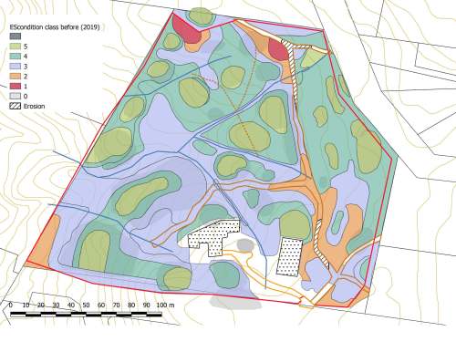
At the commencement of the works, ‘before’ photos were taken from eight pegged photopoints and at least 10 other informal ‘before’ shots across a wider range of subsites. Condition class mapping was undertaken using a 5-scale system adapted from the system used by the NSW National Trust since the 1980s.

Figure 3. (a) Before and (b) after treatment at the ‘Rabbit flat’ subsite. This area was highly drought affected and overgrazed by kangaroos and rabbits in 2019. Weed trimmings were laid on the site to reduce sheet erosion and grazing. Weeds were regularly controlled, particularly African Love Grass and Hare’s Foot Clover. Drought breaking rains triggered germination of mainly Golden Everlasting (Chrysocephalum apiculatum), New Holland Daisy (Vittadinea cuneata) and range of other natives. Very little African Love Grass and other weeds now persist at this site.

Weed treatments (totalling approx. 250 hours) were carried out over three growing seasons (Spring- Autumn) starting in December 2019 and extending till May 2022 (Table 1). By far the most hours (237) were directed to precision knapsack spot-spraying of groundcover weeds, with relatively few hours treating shrub weeds. The highest input was required in the third season, due to its exceptionally favourable rainfall (Fig. 2) when we needed to increase our inputs to treat all herbaceous weed across the whole site prior to their setting seed and recharging seed banks.

Table 1.  Hours involved in spot-spraying of groundcover weed for each of the three seasons.

Season 1  (2019-20) Season 2(2020-21) Season 3(2019-20)
77 56

Figure 2. Rainfall records at the site over three growing seasons from December 2019 to May 2022 (Blue bars is rainfall recorded at East St, Cooma; the red line the mean rainfall recorded at the Cooma Visitor’s Centre).

Results to date. While the site is far from fully recovered and works will be ongoing, results to date are encouraging. Figures 1 and 3 are three of many before and after photo pairs that compare the condition of all subsites prior to work with native plant recovery by January 2022 –24 months after the first drought-breaking rains. (Also see multiple photos at https://youtu.be/wjNviPl-MqY .) The condition classifications prior to works and at 3 seasons after works are shown in Figure 4.

In general most sites appear to have moved up in condition by at least one class; there is now substantially more area of medium to high condition after treatment compared to prior to treatment. However this result is still somewhat uncertain as the degree to which some of the Hare’s-foot Clover may have matured prior to spraying is unclear. The test of condition will be in Spring during the next above-average rainfall year.

Figure 4. Condition mapping (a) before and (b) after 3 seasons using a five-level condition classification system. The two maps show an increase in area of the green end of the spectrum (higher condition) and a reduction in area at the red end of the spectrum (lower condition). [The colour-coding and criteria are based on a four-level system used traditionally in the bush regeneration industry developed by the National Trust in the 1970s then modified during the 1990s by T. McDonald and subsequently resequenced to align with the 1-5 sequencing used in the 5-star system of the National Restoration Standards.]

Lessons learned and future directions.  The resilience level of this cold-climate, drought-affected plant community proved to be surprisingly high and growth relatively rapid after highly favourable rainfall. This may indeed be due to the species’ adaptation to periodic drought and short growing seasons.  Importantly (as elsewhere) such resilience also lends a capacity for natives to recover after periods of weed domination if that weed is removed.

It is logical to view the pattern of drought followed by highly favourable rainfall as somewhat similar to wildfire followed by highly favourable rainfall.  In such circumstances there is benefit in systematically treating as large an area as possible to (i) take advantage of the opportunities for rapid recovery of natives and (ii)  avoid massive and unusual recharge of weed seedbanks that could set a site’s condition back by many decades. While the landholders in this case did the work themselves and could increase or decrease work as required per season, cases relying on public funding would benefit from contingency funding being set aside for supporting additional restoration inputs in high rainfall seasons post-fire or post-drought.

Stakeholders.  The works were carried out by the block’s landholders Tein McDonald and Graeme Little.   Friends of Grassland helped with plant identification and encouragement and provided a small grant  to offset the costs of herbicide and equipment.

Contact:  Tein McDonald teinm@ozemail.com.au

Waterponding the Marra Creek, NSW rangelands – UPDATE of EMR feature

Ray Thompson and Central West Local Land Services

[Update of EMR feature – Thompson, Ray F (2008) Waterponding: Reclamation technique for scalded duplex soils in western New South Wales rangelands. Ecological Management & Restoration 9:3, 170-181. https://onlinelibrary.wiley.com/doi/10.1111/j.1442-8903.2008.00415.x]

Figure 1.  Scalded country with 30cm of sandy loam topsoil swept away by wind after extensive overgrazing. (Photos NSW SCS)

Introduction. Overgrazing of native pastures in the second half of the 19th Century stripped vegetation and led to the wind erosion of sandy topsoil during inevitable dry periods.  By the 1960s, tens of thousands of square kilometres of rangeland sites in western NSW had a legacy of moderate or severely bare or ‘scalded’ lands. This left bare and relatively impermeable clay subsoil which prevents water penetration and is very difficult for plants to colonize (Fig 1.)

Waterponding is the holding of water on the scald in surveyed horseshoe-shaped banks, each covering 0.4 ha. The ponds retain up to 10 cm of water after rain which leaches the soluble salts from the scalded surface. This improves the remaining soil structure, inducing surface cracking, better water penetration and entrapment of wind-blown seed. Consequently, niches are formed for the germination of this seed and recovery of a range of (typically around 15 out of a total of about 30) locally native chenopod (saltbush) grassland species on the sites.

The original 2008 EMR feature described how barren scalds at a range of properties in Marra Creek, near Nyngan in semi-arid NSW were transformed during the 1980s and 1990s into biodiverse native pastures through a technique called ‘waterponding’ developed after five decades of work by consecutive soil conservation officers exploring a range of prototype treatments.  Over time, a wide range of machines have been used to construct waterponding banks including standard road graders (ridged frame and articulated) or similar. Pre-1985 road graders were generally too small to construct banks of sufficient size, which resulted in too many breached banks. Over a 4-year period, the Marra Creek Waterponding Demonstration Program, backed by committed landowners, researched different horsepower road graders, constructing different size banks, winning the dirt from different locations, and evaluating the economics of construction methods. The results showed that the higher-powered articulated road graders exceeding 200 HP proved to be the most economical and efficient for waterpond construction. This type of machine has the power to  form the bank with one pass on the inside of the bank and two passes on the outside, achieving a bank with well over 2 m base width and over 60 cm in height (Fig. 2).

Figure 2. The process of of waterponding including (a) ute-mounted laser levelling to design the waterpond for a particular site, (b) bulldozing the pond walls to the designed levels, (c) rainfall filling the pond to allow deep watering and cracking of the clay subsoil and (d) resulting revegetation within the walls of the pond. (Photos NSW SCS)

Update and the broader program.  Photos and pasture measurements undertaken on ‘Billabong’ Marra Creek NSW, till 2014 show that the waterponding site had increased ground cover (predominantly native species) from 1% in 2005 to 84 % in 2014. After five to seven rainfall years a typical treatment can result in recovery of up to 15 native species from a range of up to 31 species (Table 1). The method in the last 20 years has also included broadcasting seed of some of the more important perennial species of healthy native chenopod grasslands including  Oldman  Saltbush  (Atriplex nummularia), Bladder Saltbush (Atriplex vesicaria) and Mitchell Grass (Astrebla   lappacea) (Fig 3).  Landholders in the Marra Creek district observe a range of fauna frequently on and between the ponds, including Western Grey Kangaroo (Macropus fuliginosus), Red Kangaroo (Macropus rufus), Emu (Dromaius novaehollandiae), Brolga (Grus rubicunda) and the Eastern Bluetongue Lizard (Tiliqua scincoides). A species of Monitor (Varanus sp.) also sometimes traverses the waterponds. Formal monitoring of smaller reptile and invertebrate use of waterponded sites is yet to occur.

Figure 3. Curly Mitchell Grass (Astrebla lappacea) sown on pond banks. (Photo NSW SCS)

Marra Creek was not the first series of waterponding programs in the Nyngan area – nor the last. The outputs of the entire program by 2019 included over 80,000 waterponds laid out and constructed, resulting in 40,000 hectares returned to local native vegetation. A total of 164 properties in the rangelands area are now using waterponding, the majority of landholders in the Marra Creek district and representing an increase from 17 landholders back in 1984 when we first ran the waterponding.

Figure 4. Landholders themselves are teaching the Waterponding technique to other landholders. (Photos NSW SCS)

Economic model of waterponding. The primary driver for land reclamation was not biodiversity conservation but returning the natural capital of rangelands. As such the program has returned a clear profit to the landholders in terms of increased native pastures that can be grazed, improving ecologically sustainable income sources for farming families.

With the reinstatement of vegetation, there have be increases in total stock feed, resulting in an increase in lambing percentages and wool cuts, as well as the ability to carry stock further into prolonged dry periods with overhead cost per head remaining static. Once rehabilitation has been completed, stocking  rates have been raised from zero to one sheep to 1.5 ha. This iseffectively the long-term grazing average for  saltbush pastures in the Nyngan district.

A treatment involving the full design and survey, pond construction and revegetation cost the landholder about $144.00 per hectare. (This includes approximately $25 a hectare for seed.) If the landholder does all the work the cost is reduced to $72/ha. The type of land involved was calculated in 2008 to normally  have  a  resale  value  of  about $365.00 per hectare In its unproductive state.  Scalded land does not contribute to the farm income yet still incurs rates. Investment in rehabilitation, in contrast, improves carrying capacity thus reducing hand-feeding costs, improving lambing percentages and avoiding forced stock sales. This allows landholders to pass the property to the next generation in a far better condition than it has been previously.

Research has found that the scalds store approximately 18.7 t/h of soil organic carbon to a depth of 30 cm. Once the landscape has been restored by waterponding and revegetation, we have found there is a rapid increase in soil organic carbon up to 25 t/ha within five years. The results are indicating that land in the rangelands that has been rehabilitated using waterponds does sequester carbon. This could lead on to waterponding being eligible for a carbon abatement activity and hopefully lead to Carbon Farming Initiative activity for carbon credits.

Figure 5. Australian National University students attending ‘21 years of participation in Rangelands Waterponding’. (Photos NSW SCS)

Potential for further application. After decades of field days and uptake of the methodologies by local graziers (Fig. 4), waterponding now forms part of standard district farming methodologies and landholders are now passing on knowledge to new generations, including through universities (Fig. 5). The methodologies have also been applied at one national park and one Trust For Nature site in Victoria, and are being applied in the Kimberley, with potential for far greater application in desert conservation reserves throughout Australia and the rest of the world (See Fig. 6 and https://justdiggit.org/approach-2/#).

Contact. Kyra Roach, Central West Local Land Services, Nyngan, 2825 Australia. Email: kyra.roach@lls.nsw.gov.au

Figure 6. A total of 79 trainees from 26 Africa countries (including Ghana, Tunisia, Rwanda, Burundi and Djibouti) over a three year period were sponsored by AusAid to study waterponding in Nyngan. Resullting work in African countries is making a big difference to degraded lands particularly in North Sudan and Kenya (Photo NSW SCS)

Table 1. Species found in waterponds after standard revegetation treatments and five to seven rainfall years. The species found by Rhodes (1987b) are still commonly found, with additional species (marked with a diamond +) observed by Ray Thompson. (Plant names are consistent with the New South Wales Herbarium database PlantNet, http://plantnet.rbgsyd.nsw.gov.au/ and  growth forms are consistent with Cunningham et al. (1981) (Exotics are marked with an asterisk)

Scientific name Common name Growth form
Alternanthera denticulata Lesser Joyweed Annual forb
Astrebla lappacea+ Curly Mitchell Grass Perennial grass
Atriplex leptocarpa Slender-fruited Saltbush Perennial subshrub
Atriplex lindleyi+ Eastern Flat Top Saltbush Annual subshrub
Atriplex nummularia+ Oldman Saltbush Perennial shrub
Atriplex pseudocampanulata Mealy Saltbush Annual subshrub
Atriplex semibaccata+ Creeping Saltbush Perennial subshrub
Atriplex spongiosa Pop Saltbush Annual forb
Atriplex vesicaria Bladder Saltbush Perennial subshrub
Centipeda thespidioides Desert Sneezeweed Perennial forb
Chamaesyce drummondii Caustic Weed Annual or short-lived perennial forb
Chloris truncata Windmill Grass Annual or perennial grass
Diplachne fusca Brown Beetle Grass Perennial grass
Eragrostis parviflora Weeping Lovegrass Annual or short-lived perennial grass
Eragrostis setifolia Neverfail Perennial grass
Hordeum leporinum* Barley Grass Annual grass
Hordeum marinum* Sea Barley Annual grass
Maireana pentagona Hairy Bluebush Perennial subshrub
Malacocera tricornis Soft Horns Perennial subshrub
Marsilea drummondii Common Nardoo Perennial forb
Medicago minima* Woolly Bur Medic Annual forb
Medicago polymorpha* Burr Medic Annual forb
Osteocarpum acropterum+ Water Weed Perennial subshrub
Phalaris paradoxa* Paradoxa Grass Annual grass
Pimelea simplex Desert Rice-flower Annual forb
Portulaca oleracea Common Pigweed Annual forb
Salsola kali var. kali Buckbush Annual or biennial forb
Sclerolaena brachyptera Short-winged Copperburr Short-lived perennia
Sclerolaena calcarata+ Red Copperburr Perennial subshrub
Sclerolaena divaricata+ Pale Poverty Bush Perennial subshrub
Sclerolaena muricata Black Roly-poly Short-lived perennial
Sclerolaena trycuspis Streaked Poverty Bush Perennial subshrub
Sporobolus actinocladus Katoora Grass Perennial grass
Sporobolus caroli Fairy Grass Perennial grass
Tragus australianus Small Burr Grass Annual grass
Tripogon loliiformis+ Five Minute Grass Perennial grass


Restoring the banks of the Namoi on Kilmarnock – UPDATE of EMR feature

Robyn R. Watson

[Update of EMR feature – Watson R. (2009) Restoring the banks of the Namoi on ‘Kilmarnock’: Success arising from persistence. Ecological Management & Restoration,  10: 1 pp 10-19 https://onlinelibrary.wiley.com/doi/10.1111/j.1442-8903.2009.00434.x]

Figure 1. Casuarina (Casuarina cunninghamiana), River Red Gum and a range of grasses established on river bank at Kilmarnock after restoration works. (Photo R. Watson)

Riverbank restoration began on Kilmarnock in early 1990 with fencing the river area and planting native trees, shrubs and grasses. A program of killing the weeping willows resulted in their elimination by 2000. Tree lines were planted to connect the river corridor to natural conservation areas around the farm and this has resulted in a gradual increase in native wildlife leading to great environmental benefits both for the farm and surrounding areas.

Prior to the works the riparian zones on Kilmarnock had degraded to the extent that the banks were slumping during floods, with loss of old trees. This had arisen from decades of clearing, grazing and weed invasion.  Since 2009 we can report that the fenced-off river corridor has continued to recover with native grasses  beneath the trees, particularly Phragmites (Phragmites australis)  and Vetiver Grass (Chrysopogon zizaniodes) which are growing well on the steep river banks (Fig 1).  As the trees in the riparian corridor grew, additional tree lines were planted throughout the farm to connect the riparian zone to retained native vegetation areas and other set-aside conservation areas. This has led to an increase in native birds, micro bats and beneficial insect numbers.

Wildlife have returned to the area, including Little Pied Cormorant (Microcarbo melanoleucos) and  Pied Cormorant (Phalacrocorax varius) nesting in the River Red Gum (Eucalyptus camaldulensis) trees one year. Flocks of Budgerigar (Melopsittacus undulatus) and Spotted Pardalote (Pardalotus punctatus)  have been observed in the trees along the riparian zones.  Pink Eared Duck (Malacorhynchus membranaceus), Musk Duck (Biziura lobata)(, Eurasian Coot (Fulica atra) and Brolga (Antigone rubicunda) visited wetland areas on the farm. There has been a noticeable increase in the small birds such as three different wrens including Superb Fairy-wren (Malurus cyaneus) and Variegated Fairy-wren (Malurus lamberti) and Australasian Pipit (Anthus novaeseelandiae).

The planted irrigated cotton crop was not sprayed with insecticide for 12 years after the increase in beneficial insect and bird numbers. Nest boxes have been installed in the conservation areas for the micro bats.  Fourteen species of insectivorous micro bats have been recorded on the farm since the rehabilitation work began. Stubble quail (Coturnix pectoralis) have been nesting in the conservation areas.

Figure 2. Log groins with planted native trees established on steep river bend near Boggabri through the Namoi Demonstration Reach Project (2007-14) coordinated by the NSW Dept of Primary Industries. (Photo R. Watson)

Further works undertaken nearby.  After seeing the improvement on our farm some adjoining landholders have begun fencing off their river areas and introducing rehabilitation measures on their farms. In one outstanding collective example, 120 kilometres of the Namoi Demonstration Reach Project was established by the NSW Dept of Primary Industries both upstream and downstream of Kilmarnock, from 2007 to 2014.  This This involved contractors, working with permission of a number of landholders, planting over eight thousand trees and shrubs along the river and constructing log groins at a badly eroding river bend near the Boggabri township.  These groins have worked well and have withstood a couple of small floods.  The trees planted on the steep banks have also established well (Fig. 2).


Figure 3. – Planted Phragmites saved the river bank from bush fire in 2017. (Photo R. Watson)

A major bushfire in 2017 spread across the river to the top of the banks on the Kilmarnock side of the river.  Because of the planted Phragmites on the river edge there was no damage done to the toe of the river bank (Fig 3) and we were able to bulldoze firebreaks to protect  the planted trees affected from the fire.)  However, a number of the old River Red Gums were badly burnt. Many of the very old hollow trees were killed by the fire but less hollow ones have begun to grow again, although this growth has been slowed by the present drought.

With the 2019 drought conditions the Namoi River has dried out, exposing the river bed.  This has given me a chance to observe the river bed.  I have been able to photograph and document the debris on the sand banks and the remaining water holes and show that there are now substantial amounts of hollow logs and debris (Fig. 4)  which can  provide good habitat for fish and water creatures when the stream is flowing.

Our family has purchased more land downstream on the Namoi River and we have implemented rehabilitation on the river banks, tree planting and conservation measures on those farms.

Contact.  Robyn Watson, Kilmarnock, Boggabri, NSW 2382, Australia; Tel: 02 67434576 Email: wjwatson@northnet.com.au

Figure 4. Hollow log and debris on riverbed provide fish habitat when river is flowing. (Photo R. Watson)


Project Eden: Fauna reintroductions, Francois Peron National Park, Western Australia

Per Christensen, Colleen Sims and Bruce G. Ward

Key words. Ecological restoration, pest fauna control, captive breeding, foxes, cats.

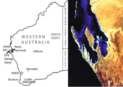
Figure 1. The Peron Peninsula divides the two major bays of the Shark Bay World Heritage Area, Western Australia.

Figure 1. The Peron Peninsula divides the two major bays of the Shark Bay World Heritage Area, Western Australia.

Introduction. In 1801, 23 species of native mammals were present in what is now Francois Peron National Park. By 1990 fewer than half that number remained (Fig 1.). Predation by introduced foxes and cats, habitat destruction by stock and rabbits had driven many native animals to local extinction.

Project Eden was a bold conservation project launched by the WA government’s Department of Conservation and Land Management (CALM -now Dept of Parks and Wildlife) that aimed to reverse extinction and ecological destruction in the Shark Bay World Heritage Area.

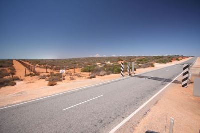
The site and program. Works commenced in Peron Peninsula – an approx. 80 km long and 20 km wide peninsula on the semi-arid mid-west coast of Western Australia (25° 50′S 113°33′E) (Fig 1). In the early 1990s, removal of pest animals commenced with the removal of sheep, cattle and goats and continued with the control of feral predators. A fence was erected across the 3km ‘bottleneck’ at the bottom of the peninsula where it joins the rest of Australia (Fig 2) to create an area where pest predators were reduced to very low numbers.

Figure 2. The feral proof fence was erected at the narrow point where Peron Peninsula joins the mainland.

Figure 2. The feral proof fence was erected at the narrow point where Peron Peninsula joins the mainland.

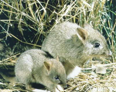
Once European Red Fox (Vulpes vulpes) (estimated at 2500 animals) was controlled and feral Cat (Felis catus) reduced to about 1 cat per 100 km of monitored track, sequential reintroductions of five locally extinct native animals were undertaken (Figs 3 and 4).  These included: Woylie (Bettongia penicillata – first introduced in 1997), Malleefowl (Leipoa ocellata – 1997), Bilby (Macrotis lagotis – 2000), Rufous Hare-wallaby (Lagorchestes hirsutus – 2001), Banded Hare-wallaby (Lagostrophus fasciatus -2001), Southern Brown Bandicoot (Isoodon obesulus – 2006) and Chuditch (Dasyurus geoffroi geoffroi -2011?)

Methods. Cat baiting involved Eradicat® cat baits, which were applied annually during March–April at a density of 10 to 50 baits/km2. Cat baiting continued for over 10 years, supplemented with a trapping program, carried out year round over a 8 -year period. Cat trapping involved rolling 10 day sessions of leghold trapping along all track systems within the area, using Victor Softcatch No. 3 traps and a variety of lures (predominantly olfactory and auditory).Tens of thousands of trap nights resulted in the trapping of up to 3456 animals. Fox baiting involved dispersal of dried meat baits containing 1080 poison by hand or dropped from aircraft across the whole peninsula. Baiting of the peninsula continues to occur annually, and removes any new foxes that may migrate into the protected area and is likely to regularly impact young inexperienced cats in the population, with occasional significant reductions in the mature cat population when environmental conditions are favourable.

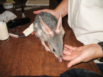
Malleefowl were raised at the Peron Captive Breeding Centre from eggs collected from active mounds in the midwest of Western Australia. Woylies were reintroduced from animals caught in the wild from sites in the southwest of Western Australia, with Bilbies sourced from the Peron Captive Breeding Centre, established by CALM in 1996 to provide sufficient animals for the reintroductions. The centre has since bred more than 300 animals from five species

Monitoring for native mammals involved radio-tracking of Bilbies, Woylies, Banded Hare Wallabies, Rufous Hare-Wallabies, Southern Brown Bandicoots, Chuditch and Malleefowl at release, cage trapping with medium Sheffield cage traps and medium Eliots, as well as pitfall trapping of small mammals. The survey method for cats utilized a passive track count survey technique along an 80 km transect through the long axis of the peninsula. The gut contents of all trapped cats were examined.

Fig. 3. Woylies were first introduced in 1997 from animals caught in the wild at sites in southwest Western Australia.

Figure 3. Once foxes were controlled and cats reduced to about 1 cat per 100 km of monitored track, sequential reintroductions of five locally extinct native animals were undertaken. Woylies were first introduced in 1997 from animals caught in the wild at sites in southwest Western Australia.

Once European Red Fox (Vulpes vulpes) (estimated at 2500 animals) was controlled and feral Cat (Felis catus) reduced to about 1 cat per 100 km of monitored track, sequential reintroductions of five locally extinct native animals were undertaken.

Figure 4. Tail tag being fitted to a Bilby. (Bilbies were re-introduced to the Peron Peninsula in 2000, from animals bred in the Peron Captive Breeding Centre.)

Results. Monitoring has shown that two of the reintroduced species – the Malleefowl and Bilby – have now been successfully established. These species are still quite rare but they have been breeding on the peninsula for several years The Woylie population may still be present in very low numbers, but despite initial success and recruitment for six or seven years, has gradually declined due to prolonged drought and low level predation on a small population. Although the released Rufous Hare-wallabies and the Banded Hare-wallabies survived for 10 months and were surviving and breeding well, they disappeared because of a high susceptibility to cat predation and other natural predators like wedge-tailed eagles. Although some predation of Southern Brown Bandicoot has occurred and the reintroduction is still in the early stages, this species has been breeding and persisting and it is hoped that they will establish themselves in the thicker scrub of the peninsula.

Lessons learned. We found that the susceptibility to predation by cats and foxes varies considerably between species. Malleefowl are very susceptible to fox predation because the foxes will find their mound nests, dig up their eggs up and eat them – consequently wiping them out over a period of time. As cats can’t dig, Malleefowl can actually exist with a fairly high level of cats. Bilbies live in their burrows and are very alert so they can persist despite a certain level of cats. But the Rufous Hare-wallaby and the Banded Hare-wallaby are very susceptible to cat predation and fox predation due to their size and habits.

Examination of the period of time when species disappeared from the Australian mainland showed that there was a sequence of extirpations, reflecting the degree to which the species were vulnerable to pest predators. The ones that survived longest are those that are less vulnerable. This suggests that if complete control of predators is not possible (considering cat control is extremely difficult), it is preferable to focus on those animals that are least vulnerable. While it could be argued that reintroductions should be delayed until such time as all the cats and foxes have been removed, such a delay (which might take us 10, 20 or even 100 years) is likely to exceed the period of time many of these species will survive without some sort of assistance. It is likely to be preferable to proceed with reintroductions although we might be losing some animals.

Future directions. As with the majority of mainland reintroduction projects, level of predator control is the key to successful establishment of reintroduced fauna. The Project is currently under a maintenance strategy and future releases, which included the Western Barred Bandicoot (Perameles bougainville), Shark Bay Mouse (Pseudomys fieldi), geoffroi), Greater Stick-nest Rat (Leporillus conditor) and Red-tailed Phascogale (Phascogale calura) are on hold until improved cat control techniques are available. Despite the uncertain future for reintroductions of these smaller species, ongoing feral animal control activities and previous reintroductions have resulted in improved conditions and recovery for remnant small native vertebrates (including thick billed grass wrens, woma pythons and native mice), and new populations of several of the area’s threatened species which are once again flourishing in their original habitats.

Acknowledgements: the program was carried out by Western Australia’s Department of Parks and Wildlife and we thank the many Departmental employees, including District and Regional officers for their assistance over the years, and the many, many other people that have volunteered their time and been a part of the Project over the years, for which we are very grateful.

Contact: Colleen Sims, Research Scientist, Department of Parks and Wildlife (Science and Conservation Division, Wildlife Research, Wildlife Place, Woodvale, WA 6026, Australia, Tel: +61 8 94055100; Email: colleen.sims@dpaw.wa.gov.au). Also visit: http://www.sharkbay.org.au/project-eden-introduction.aspx

Further detail and other work in WA:

Per E. S. Christensen, Bruce G. Ward and Colleen Sims (2013) Predicting bait uptake by feral cats, Felis catus, in semi-arid environments. Ecological Management & Restoration 14:1, 47-53.

Per Christensen and Tein McDonald (2013) Reintroductions and controlling feral predators: Interview with Per Christensen. Ecological Management & Restoration, 14:2 93–100.


Peniup Ecological Restoration Project

Justin Jonson

Key words: reconstruction, planning, direct seeding, monitoring, innovation

Introduction. The Peniup Restoration Project was initiated in 2007, when Greening Australia and Bush Heritage Australia jointly purchased a 2,406 hectare property as a contribution to the conservation and restoration objectives of Gondwana Link. The property has an average annual rainfall of approximately 450mm per year and had previously been farmed in a traditional broad acre sheep and cropping rotation system. The site is located within a highly diverse mosaic of varying soils and associated vegetation associations across Mallee, Mallee Shrubland, and Woodland type plant communities.

Planning and 2008 Operational Implementation. In 2008, Greening Australia’s Restoration Manager Justin Jonson developed a detailed ecological restoration plan for 950 hectares of cleared land on the northern section of the property. Information and procedures applied for that work are detailed in the EMR Journal article Ecological restoration of cleared agricultural land in Gondwana Link: lifting the bar at ‘Peniup’ (Jonson 2010). Further information is also available for the specific vegetation associations established via the Peniup Restoration Plan, with species lists according to height stratum, including seedlings planted by hand which were nitrogen fixing or from the Proteaceous genera. Funding for the initial 250 hectares of restoration were raised and the project implemented in 2008 (Fig.1).

Figure 1. Map showing the 2008 operational areas at Peniup with replanted communities replanted by direct seeding, and GPS locations of permanent monitoring plots (n=42), patches of hand planted seedlings (n=31) and seed (n=61), pre-planning soil sampling sites (n=115) and contour oriented tree belts to ensure establishment across the site (direct seeded understory consistently here).

Figure 1. The 2008 operational areas at Peniup showing communities replanted by direct seeding, and GPS locations of permanent monitoring plots (n=42), patches of hand planted seedlings (n=31) and seed (n=61), pre-planning soil sampling sites (n=115) and contour oriented tree belts to ensure establishment across the site.

Figure 2: Map showing GPS locations of permanent monitoring plots established at Peniup.

Figure 2. Location of 42 Permanent Monitoring Plots established in 2008 Peniup Ecological Restoration Project. Recruits from the direct seeding were measured 5 months after implementation, and then annually to assess persistence and long term development

Monitoring. A total of 42 monitoring plots were laid out across seven of the nine plant communities established (Fig.2). Details of the methodology, results and ongoing evaluation have been published (Jonson 2010; Hallet et al. 2014; Perring et al. 2015).

Results to date.  Monitoring indicates approximately 3.8 million plants were re-established by the direct seeding across the 250 hectare project area.  The numbers established in each plant community are shown in Fig.3 and represent the majority of plant species in each reference model. After 8 years it is clear that the project’s objectives are on track to being achieved, considering: a) absence of agricultural weeds; b) nutrient cycling through build up and decomposition of litter and other detritus;  seed-rain by short-lived nitrogen-fixing Acacia shrubs, c) diverse structural development of re-establishing species; and,  d) presence of many target animals using the site. Peniup’s progress in terms of recovery of the National Restoration Standards’s 6 ecosystem attributes is depicted and tablulated in Appendix 1.

Figure 3: Chart showing per hectare estimates of plant establishment counts by restoration plant community.

Figure 3. Per hectare estimates of Peniup plant establishment counts by restoration plant community.

Figure 4. Photo of riparian/drainage Tall Yate open woodland community with mid and understory shrubs and mid-story trees.

Figure 4. Riparian/drainage Tall Yate open woodland community at Peniup – with mid and understory shrubs and mid-story trees.

Innovation. As an adaptive management approach, small, discrete patches of seedlings of the proteaceous family were hand planted to make best use of small quantities of seed. Planting of these 5,800 seedlings in small patches, termed ‘Nodes’, provided further resource heterogeneity within relatively uniform seed mixes (by soil type). The impetus for this approach was to create concentrated food sources for nectarivorous fauna, while increasing pollination and long-term plant species viability (Jonson 2010).

Figure 5. Map showing distribution of Proteaceous Nodes.

Figure 5. Distribution of Proteaceous Nodes.

Lessons learned. Continuity of operational management is a critical component to achieving best practice ecological restoration. Project managers must be involved to some degree in all aspects of works, because flow on consequences of decisions can have high impact on outcomes. Detailed planning is also needed with large scale projects; otherwise the likelihood of capturing a large percent of site specific information is low. Finally, the use of GIS software for information management and site design is an absolute necessity.

Figure 6. Photo showing Banksia media and Hakea corymbosa plants with seed set.

Figure 6. Banksia media and Hakea corymbosa plants with seed set after 5 years.

Figure 7. hoto showing bird nest built within re-establishing Yate tree at Peniup within 5 years.

Figure 7. Bird nest within 5-year old Yate tree at Peniup.

Figure 8. Photo showing ecological processes in development including, a) absence of agricultural weeds, b) nutrient cycling and seed-rain deposition by short-lived nitrogen-fixing Acacia shrubs, c) diverse structural development of re-establishing species, and d) development of leaf litter and associated detritus for additional nutrient cycling.

Figure 8.  Five-year-old vegetation is contributing to a visible build up of organic matter and decomposition is indicating cycling of nutrients.

Stakeholders and Funding bodies. Funding for this Greening Australia restoration project was provided by The Nature Conservancy, a carbon offset investment by Mirrabella light bulb company, and other government and private contributions.

Contact information. Justin Jonson, Managing Director, Threshold Environmental, PO Box 1124, Albany WA 6330 Australia, Tel:  +61 427 190 465; jjonson@thresholdenvironmental.com.au

See also EMR summary Monjebup

See also EMR feature article Penium project

Watch video: Justin Jonson 2014 AABR presentation on Peniup

Appendix 1. Self-evaluation of recovery level at Peniup in 2016, using templates from the 5-star system (National Standards for the Practice of Ecological Restoration in Australia)

Fig 9. Peniup recovery wheel template

Evaluation table2

Defining reference communities for ecological restoration of Monjebup North Reserve in Gondwana Link

Justin Jonson

Key words: reconstruction; reference ecosystem; planning; ecosystem assemblage; monitoring

Introduction. Bush Heritage Australia’s (BHA) Monjebup North Reserve is a property that directly contributes to the conservation, restoration and connectivity objectives of Gondwana Link – one of Australia’s leading landscape scale restoration initiatives. Building on a solid history of revegetation projects implemented by collaborators from Greening Australia and individual practioners, the BHA management team initiated and funded a $40K Ecological Restoration Planning Project for 400 hectares of marginal farmland in need of restoration.

The specific aim of the Monjebup North Ecological Restoration Project was to 1) plan and 2) implement a ‘five star’ ecological restoration project as defined by the Gondwana Link Restoration Standards. Overarching goals included the re-establishment of vegetation assemblages consistent with the surrounding mosaic of plant communities, with a specific focus on local fauna and the restoration of habitat conditions to support their populations.

Figure 1: Map showing GPS locations of soil auger sampling locations.

Figure 1: Map showing GPS locations of soil auger sampling locations.

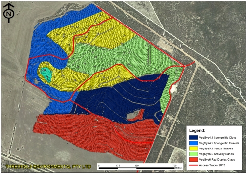
Planning and identification of reference communities for restoration of cleared land. The Monjebup North Ecological Restoration Project began with a third party consultancy contract to develop the Monjebup North Ecological Restoration Plan. This work began with the collection of detailed field data, including 120 soil survey pits collected to define the extent and boundaries between different soil-landform units occurring on the site (Fig.1). In the absence of previously defined and/or published information on local plant communities, an additional vegetation survey and report, The Vegetation of Monjebup North, was developed, which included 36 vegetation survey sites widely distributed across the surrounding vegetation (Fig.2). A total of 10 primary vegetation associations were defined within remnant vegetation on and around the site from this work (Fig.3). Additional soil survey pits were established within these defined plant communities to develop relationships between observed vegetation associations and soil-landform units. Cross referencing this information to the 400 hectare area of cleared land resulted in the delineation of seven core reference communities to guide the restoration project. These restoration communities ranged from Banksia media and Eucalyptus pluricaulis Mallee Scrub associations on spongelitic clay soils, to Eucalyptus occidentalis (Yate) Swamp Woodland associations located in low-lying areas where perched ephemeral swamps exist.

Figure 2: Map showing GPS locations of flora survey sampling sites.

Figure 2: Map showing GPS locations of flora survey sampling sites.

Figure 3: Output map of dominant vegetation associations at Monjebup North Reserve.

Figure 3: Output map of dominant vegetation associations at Monjebup North Reserve.

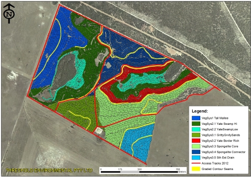
Figure 4: Mosaic of plant communities replanted at Monjebup North in 2012 using direct seeding and hand planted seedlings. A tractor fitted with GPS unit enables real time seeding passes, as shown on the map.

Figure 4: Mosaic of plant communities replanted at Monjebup North in 2012 using direct seeding and hand planted seedlings. A tractor fitted with GPS unit enables real time seeding passes, as shown on the map.

Figure 5: Mosaic of plant communities replanted at Monjebup North in 2013 using direct seeding and hand planted seedlings. A tractor fitted with GPS unit enables real time seeding passes, as shown on the map.

Figure 5: Mosaic of plant communities replanted at Monjebup North in 2013 using direct seeding and hand planted seedlings. A tractor fitted with GPS unit enables real time seeding passes, as shown on the map.

Seed sourcing. Seed from approximately 119 species were collected on and around the site for the restoration works. Seed collections for some species were collected from a number of geographically separate sub-populations, however these were never located further than 10 kilometers from site. Collections were made from at least 20 individuals for each species, and preference was made in collecting from populations which had 200+ individuals.

The primary on-ground works were initiated across four years from 2012 to 2015, starting with a 100 ha project area in 2012 (Fig.4), and a 140 ha area in the following year (Fig.5), both by Threshold Environmental Pty Ltd. A combination of direct seeding and hand planted seedlings treatments were employed, where seed mixes were developed to achieve the bulk of plant recruitment across each of the soil-land form units, and nursery grown seedlings were planted by hand for species found to be difficult to establish from direct seeding or for which stocking densities were to be more closely controlled. This work involved 13 communities and 148 species.

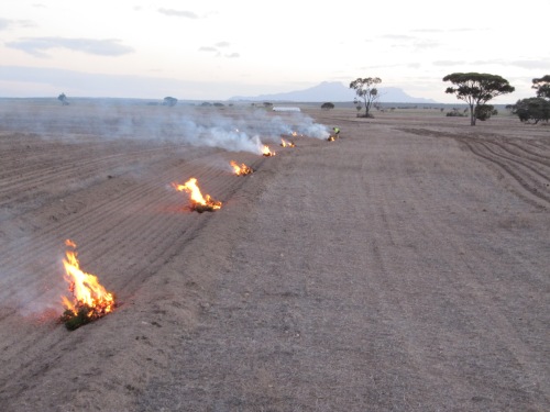
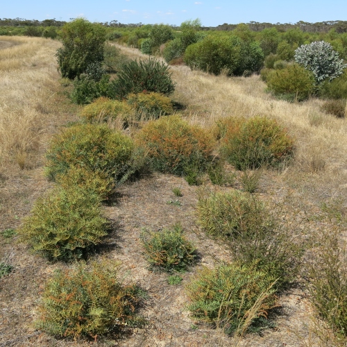
A number of innovative operational treatments were employed. These included grading 5 kilometers of contour banks and spreading chipped vegetation and seed pods, and 180 in situ burning patches where branch and seed material from fire-responsive serotinous species were piled and burned (Fig.6 before, Fig.7 after). Seedlings for rare, high nectar producing plant species were also planted in 203 discrete ‘node’ configurations. Habitat debris piles made of on-site stone and large branch materials were also constructed at 16 locations across the 2012 project areas.

Fig.6 In situ burning of serotinous branch and seed material

Figure 7: Photo of Dryandra nervosa juvenile plants establishing from one of the in situ burn pile locations. Other species used for this technique included Dryandra cirsioides, Dryandra drummondii, Hakea pandanicarpa, Isopogon buxifolius, and Hakea corymbosa.

Figure 7: Photo of Dryandra nervosa juvenile plants establishing from one of the in situ burn pile locations. Other species used for this technique included Dryandra cirsioides, Dryandra drummondii, Hakea pandanicarpa, Isopogon buxifolius, and Hakea corymbosa.

Monitoring. Monitoring plots were established to evaluate the direct seeded revegetation, as presented in the Project Planting and Monitoring Report 2012-2013. Fauna monitoring has also been undertaken by BHA using pit fall traps, LFA soil records, and bird minute surveys.

Results to date. Monitoring collected from post establishment plots in from the 2012 and 2013 areas (2 years after seeding) showed initial establishment of 2.4 million trees and shrubs from the direct seeding (Fig.8 and Fig.9). Results of faunal monitoring are yet to be reported, but monitoring at the site for vegetation and faunal is ongoing.

Figure 8: Graphic representation of monitoring results from 2012 and 2013 operational programs showing scaled up plant counts across the plant community systems targeted for reconstruction.

Figure 8: Graphic representation of monitoring results from 2012 and 2013 operational programs showing scaled up plant counts across the plant community systems targeted for reconstruction.

Figure 9: Photo showing 3 year old establishment and growth of a Banksia media/Eucalyptus falcata Mallee shrub plant community with granitic soil influence from the 2012 Monjebup North restoration project.

Figure 9: Photo showing 3 year old establishment and growth of a Banksia media/Eucalyptus falcata Mallee shrub plant community with granitic soil influence from the 2012 Monjebup North restoration project.

Lessons learned and future directions. The decision to develop a restoration plan in advance of undertaking any on-ground works was a key component contributing to the success of the project to date. Sufficient lead time for contracted restoration practitioners to prepare (>12 months) was also a key contributor to the success of the delivery. Direct collaboration with seed collectors with extensive local knowledge also greatly benefited project inputs and outcomes.

Stakeholders and Funding bodies. This project is a part of the Gondwana Link initiative. Major funding for the project was provided by Bush Heritage Australia and Southcoast Natural Resource Management Inc., via the Federal Government’s National Landcare Program and the Biodiversity Fund. This work would not have been possible without Bush Heritage Australia, who purchased and continue to manage the Monjebup North Reserve as a part of their larger conservation estate. Threshold Environmental are grateful for the opportunity to be engaged in these works.

Contact information. Justin Jonson, Managing Director, Threshold Environmental, PO BOX 1124, ALBANY WA 6330 +61 427 190 465; jjonson@thresholdenvironmental.com.au

See also EMR summary Peniup

 Watch video: Justin Jonson 2014 AABR presentation

Brush pack experiment in restoration: How small changes can avoid leakage of resources and underpin larger scale improvements for restoration and rehabilitation

David Tongway and John Ludwig

Key words: Landscape Function Analysis, biological foci, water harvesting, desertification, erosion

The following experiment illustrates how relatively small changes to redirect water flow can capture water and other biological resources at a restoration site. However the process occurs not only at the micro scale but cumulates to site and landscape scales, making it a primary underpinning principles of a method of site analysis, Landscape Function Analysis (LFA) that has been applied across Australia and other countries to assist land managers counter desertification by redesigning processes that regulate the flow of resources, minimise losses and foster cycling. See http://members.iinet.net.au/~lfa_procedures/

The LFA mindset and methodology involve a purposeful change of focus from listing the biota/ species present or absent at a site, to an examination of the degree to which biophysical processes deal with vital resources with respect to stresses arising from management and climatic events.

Fig 1 before

Fig. 1. Before: bare, crusted, low OC soil, erosion, and high water runoff mainitained by low but persistent, set-stock grazing by sheep and kangaroos.

Fig 2. after treatment

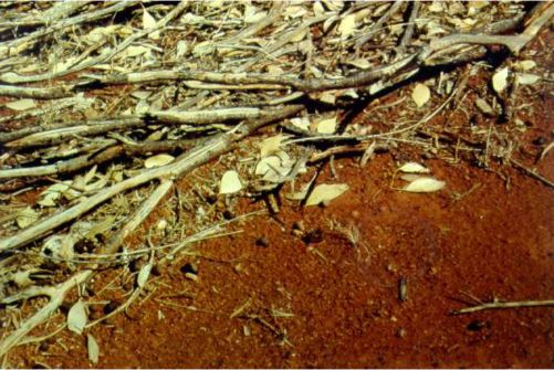
Fig. 2. The restoration treatment was simply to build brush-packs across the contour to trap water, soil and plant litter, slowing overland outflow. This also prevented the grazing down to ~1cm. Grass plants were able to maintain about 10cm of photosynthetic tissue.

Fig 4

Fig 3. After 7 years. Clearly the soil properties have improved the ‘habitat quality’ for the target vegetation.

Fig 5 14 years after

Figure 4. After 14 years, native vegetation re-established.

Fig 3. detail of bushpack after 3 years.

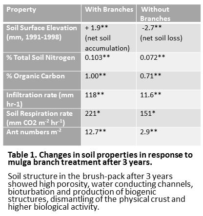
Fig 5. Detail of the brushpack after 3 years showing micro-structures capable of slowing water and accumulating resources.

1. tongway table

ANOTHER KEY OBSERVATION RELEVANT TO RESTORATION AND REHABILITATION

Where resources are not captured or leak out of a system, patchiness will become evident as resources self-organise around foci of accumulation – creating ‘patches’ where resources accumulate and ‘interpatches’ from which they ‘leak’.

The Golden Rule for rehabilitation is: “Restore/replace missing or ineffective processes in the landscape in order to improve the soil habitat quality for desired biota.”

Fig 6. Grassy sward healthy

Fig. 6. A grassy sward patch where the grass plants are close enough together that the water run-off is unable to generate enough energy to redistribute the grassy litter, which is evenly distributed. (The slope is from top to bottom in the image.)

There is also no evidence of sediment transport (not visible in this image). This is because of the tortuous path and short inter-grass distance. It would be possible to derive the critical grass plant spacing for “sward” function in any landscape, taking into account slope, aspect and soil texture.

Fig 7. Grassland in patch-interpatch mode, due to exceeding the critical runoff length for erosion initiation. (Slope is from top to bottom.)

Note that litter and sediment have both been washed off the inter-patch and have been arrested by a down-slope grass patch. Note the orientation of the grassy litter strands.


Nowanup: Healing country, healing people

Keith Bradby, Eugene Eades, Justin Jonson, Barry Heydenrych.

Key words: Noongar, Gondwana Link, cultural restoration, ecological restoration, design

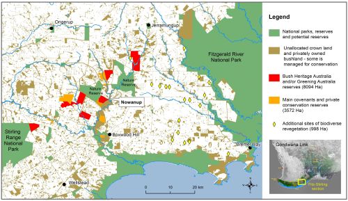
Introduction. Greening Australia’s 754 ha Nowanup property was one of the first purchased with donor funds to help achieve the Gondwana Link programme’s goal of reconnecting native habitats across south-western Australia (Fig 1). The ecological work of Gondwana Link is underpinned by the involvement of people living within the region’s landscapes.

Nowanup (Fig 2) is a visually compelling place, with rising breakaway mesas, broad sweeping plains, and views south down the Corackerup valley and south west to the Stirling Range. Its remaining native vegetation systems are dominated by mallee shrublands, mallet and moort woodlands and banksia heathlands. It contains large populations of the locally endemic eucalypts Corackerup Moort (Eucalyptus vesiculosa) and Corackerup Mallet (E. melanophitra) and it is expected that additional rare flora species will be found. It also supports populations of a range of threatened fauna species including Malleefowl (Leipoa ocellata), Western Whipbird (Psophodes nigrogularis), Shy Groundwren (Hylacola cauta whitlocki), Crested Bellbird (Oreoica gutturalis gutturalis) and Black-gloved wallaby (Macropus irma). The original native vegetation remains in the upper section of the property (Fig 3), though much of this area has been cleared and burnt for farming, but never farmed. The farmland areas are now largely replanted.

Fig 1 Fitz-Stirling Corridor

Fig. 1. Nowanup is part of the broader Gondwana Link Program

Fig 2. Nowanup rock features

Fig. 2. Nowanup has visually compelling rock features and expansive landscapes.

Cultural significance. The groups involved in Gondwana Link support a range of social and cultural activities involving donors, farmers, government agencies, research bodies, industry groups and various landcare and natural resource management groups. Primary among these are the Aboriginal People, which for Nowanup is the local Noongar community.

Many Noongar elders knew the area well before it was cleared for farming, and speak of its cultural significance. Cultural mapping on the property has underlined that significance by locating a number of cultural sites and concentrations of artefacts. After purchase in 2004 the property was made available to the Noongar community, to support their aspirations, and Noongar leader Eugene Eades resides on Nowanup. Initially employed by Greening Australia as an Indigenous Engagement Officer, and now running camps and events at Nowanup as a Noongar led program, Eugene liaises with educational, corrections and welfare institutions and agencies to coordinate a range of educational and rehabilitation programmes. Eugene has also managed, with a team of young Noongar men, construction of a ‘Meeting Place’ that has assumed considerable significance for the local Noongar community (Fig 4).

Located in the heart of the Fitz-Stirling section of Gondwana Link, with its striking scenic qualities, a powerful sense of place, basic building infrastructure, cultural ‘Meeting Place’, and resident Noongar manager, Nowanup has become the focus for educational and cultural activities and programmes in the Fitz-Stirling, including an increasing level of Noongar involvement in the restoration plantings. These have included planting seedlings during community days and the expert planting of thousands of seedlings by four Noongar boys undertaking an eight week justice diversion program under Eugene Eades.

Fig 3 Nowanup aerial 2014. Courtesy Airpix

Fig. 3. The upper section of the property contains remnant or regrowth native vegetation, with the rest actively farmed prior to the revegetation

Approximately 340ha of the northern portion of the property is remnant bushland, with approximately 350 hectares of cleared land to the south, which has now been largely revegetated, including with trials of local species with commercial potential.

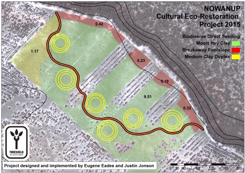
Some of the earlier plantings reflected a low-diversity revegetation approach, which was later improved across Gondwana Link plantings to better reflect the goal of ecological restoration modelled on local reference sites (see Monjebup summary). Nowanup’s early revegetation efforts were also impacted by difficulties in achieving good germination of a number of species on the sites difficult clay soils, with the result that many areas are dominated by a few species of eucalypts and acacias. These have been enriched recently by in-fill plantings which also demonstrate an improvement in the standard of work over 10 years. This has included improvements in the agronomy of direct seeding techniques (by Geoff Woodall), such as using direct drilling instead of scalping, that Greening Australia undertook in 2014, and which has subsequently been more widely used. In addition, integration of cultural and ecological aspects was advanced through a 2015 direct seeding project collaboratively designed by Eugene Eades and restoration practitioner Justin Jonson, which integrates indigenous cultural meaning and values into an ecological restoration project (Fig 4). The planting is only a year old, but the integration of cultural values and the sites biophysical conditions into one inclusive design is a powerful and innovative step forward. The site has been coined ‘Karta-Wongkin-Jini’ by Mr. Eades, which means ‘place where people come together’, and , with fantastic germination to date, is on track to serve as an important demonstration of culturally informed ecological restoration in practice.

Fig 4. Cultural EcoRestoration Systems 2015

Fig. 4. Eco-restoration design by Eugene Eades and Justin Jonson

Fig5. Cultural presentation Nowanup

Fig. 5. Schoolchildren enjoying a cultural presentation at the ‘Meeting Place’

Healing nature, healing people. Greening Australia was committed from the outset to engagement of the Noongar community in its operation in the Fitz-Stirling section of Gondwana Link. A cultural benefit of the project that was largely unforeseen but which developed rapidly has been the realization of the opportunities Nowanup presents for a range of programmes that support young Noongars at risk, as well as for rehabilitation and respite care. Eugene Eades has already supervised several Court arranged and respite care programmes on the property, and there is intense interest from a wide range of organisations in utilizing Eugene and Nowanup for running an extended range of programmes in the future (Fig 5). A project focused on the healing of country has great potential also for healing people.

The running of such programmes is out of scope for a conservation NGO whose mission is the transformation of landscape at scale. The programmes to date have made do with the very basic infrastructure that currently exists on Nowanup, with Greening plus supporters and donors subsidizing Eugene’s role in managing the programmes. Even while operating on this ad hoc basis, the programmes have proved Nowanup’s enormous potential for expanded cultural and social endeavours in the future. Greening Australia is keen to contribute to a transition that will allow for Nowanup’s full potential for such purposes to be realized.

Fig 6. Noongar planters by Ron D'Raine

Fig 6. Elder Aden Eades, Eugene Eades and Bill Woods lead a community planting day on Nowanup

Issues and Options. The framework plantings and larger scale direct seeding on Nowanup is now essentially complete, with the last significant works having been undertaken in 2015 – although infill plantings and seeding will occur as funding allows (Fig 6). From this point on, continuing conservation management of the property is required to ensure its contribution to ecological health in the Fitz-Stirling increases as the restoration work matures. With Greening Australia’s key focus on ecological restoration, there is no reason why properties that have been restored should not be subsequently divested to alternative ownership, so long as the necessary conservation covenants and management arrangements are in place. With Nowanup this would ideally be a body representative of local Noongar community interests. With both the original habitat areas and the revegetation and restoration areas already under protective covenant, the agreements and arrangements can be put in place to provide certainty for investment by corrections and/or welfare agencies into the infrastructure required to run properly-resourced programmes on the property. Nowanup will then be better placed to realize its full potential in healing country and people.

Funding: Revegetation costs were largely met through the Reconnections program, funded by Shell Australia, the Commonwealth Government’s Biodiversity Fund and 20 Million Trees Programme. Eugene Eades funds the cultural and social programs as a private business. Gondwana Link Ltd and Greening Australia provide support as needed.

Contact: Keith Bradby, Gondwana Link. PO Box 5276, Albany WA 6332. Phone: +61 (0)8 9842 0002. Email: bradby@gondwanalink.org

Read also EMR project summaries: