Category Archives: Pest animal issues & solutions

The rise of invasive ant eradications since the success of the Kakadu project  – UPDATE of EMR feature

Benjamin D Hoffmann

[Update of EMR feature – Hoffmann,  Benjamin D and Simon O’Connor (2004) Eradication of two exotic ants from Kakadu National Park. Ecological Management & Restoration, 5:2, 98-105. https://onlinelibrary.wiley.com/doi/10.1111/j.1442-8903.2004.00182.x]

Key words. pest species management, invasive species, biosecurity

Figure 1. Kakadu staff in 2001 spreading formicide over a super-colony of African Big-headed Ant. This involved a team of people, aligned in a row, walking from one edge of the infested area to the other in parallel paths. (Photo courtesy of Simon O’Connor.)

Introduction. Invasive species management, especially eradications, has been at the forefront of biodiversity conservation gains over the past two decades. For example, over 1,200 invasive vertebrate eradications have been achieved on over 800 islands worldwide and the conservation benefits of such actions have been overwhelmingly positive and often dramatic. Efforts against invasive ants have also been particularly notable over the past two decades, with ants now being the second-most eradicated taxa globally having been eradicated from more than 150 locations, with the largest eradication covering 8300 ha. Two decades ago there were only 12 confirmed ant eradications using modern baits with a combined area totalling a mere 12 ha.

As reported in our original EMR feature, the last treatments against two invasive ants in Kakadu National Park, northern Australia: The African Big-headed Ant (Pheidole megacephala) and the Tropical Fire Ant, (Solenopsis geminata) were conducted in 2003; and the ants were declared eradicated two years later (Hoffmann & O’Connor 2004). At the time this was a globally significant eradication, and the positive outcome was a partial catalyst for the creation of many other relatively small exotic ant eradication attempts around Australia, including against Tropical Fire Ant on Melville island, and African Big-headed Ant on Lord Howe Island. Incidentally, the work coincided with the approximate timeframe of when two other highly invasive ant species were first detected in Australia: Red Imported Fire Ant (RIFA) (Solenopsis invicta), and Electric Ant (Wasmannia auropunctata), prompting the initiation of two massive national cost-shared eradication programs. One of these, the RIFA program, has become Australia’s second-most expensive eradication program at AUD $428 million as of at July 2019. Together, all of these actions put ants high on Australia’s biosecurity and environmental management radars, prompting the development of Australia’s Tramp Ant Threat Abatement Plan and yet even more eradication programs.

Figure 2. Ant bait being dispersed aerially by helicopter using an underslung spreader and side-mounted dispersers. (Photos Ben Hoffmann)

Further advancements in ant eradication programs.  As Australia’s eradication programs became more numerous and larger, it became apparent very quickly that the methodologies and technologies available were insufficient to achieve success in the increasingly challenging conditions being encountered. In response, over the next two decades, there has been an impressive range of advancements that significantly improved our capacity to manage and eradicate invasive ant incursions.

The biggest issue was that work needed to be conducted over such large or inaccessible areas that ground-based work (Fig 1) was not feasible. So, treatments quickly became aerial, using multiple helicopter-based delivery platforms (e.g. underslung buckets and side-mounted hoppers, Fig 2). Even so, there have been locations that are too remote, too small, or too difficult (ie cliffs) to treat using a helicopter. To meet this challenge, in just the last five years treatments have been conducted for the first time using drones, and there is a great focus now to improve the technology so that it becomes more cost effective and more autonomous (Fig 3). This is occurring at such a pace that just a few years ago drones could only operate for a few hours at most on battery power, and only carry a few kilograms. This year we will be using a drone with unlimited flying capacity (petrol driven) that can lift 70 kg per load.
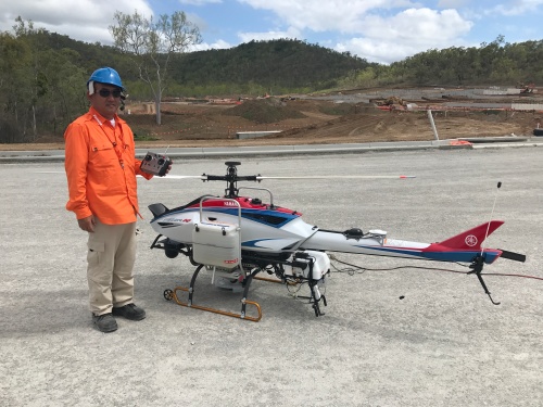
Figure 3. The Fazer with side-mounted bait carriers that can lift up to 40kg of payload. This is soon to be superseded by a drone that can lift a 70k g payload. (Photo Ben Hoffmann)

Assessments for the presence of ants, either before or after treatments, was originally very time consuming, involving teams of people walking ground very slowly and often utilising thousands of attractive lures (Fig 4). At most, only small ant populations (about less than 20 ha) within good working environments (ie open landscapes) could be assessed using teams of people, and it took large amounts of time. It was found very quickly that detector dogs could be trained on the scent of each ant species, and a single dog could cover more than five times the area of a team of people in a single day with greater efficacy (Fig 5). There are now more than 20 detector dogs operating in Australia and New Zealand that have been trained on the scent of four ant species. But even a team of dogs cannot fully cover entire areas at the landscape-scale, such as is the case for the RIFA program, especially in areas with long grass or rugged terrain. One of the saving technologies for the RIFA program has been the development of a multi-spectral sensor and associated algorithms that can identify RIFA nests from imagery captured by remote sensing (Fig 6). This allows program staff to assess just a few identified point locations in a landscape rather than the entirety of landscapes, to determine RIFA presence or absence. The next envisaged step is the development of biosensors that can detect the odours of target ant species, just like detector dogs, and with time these will become small enough to be transported by small drones throughout landscapes to detect ants.

Figure 4. An area covered with hundreds of flags marking spoonfulls of catfood being used as lures to attract African big-headed ant to assess eradication success or failure. (Photo Ben Hoffmann)

Figure 5. An ant detector dog searching for the presence of Red imported fire ant. (Photo courtesy of The State of Queensland (Department of Agriculture and Fisheries 2010–2019))

Australia was caught particularly unprepared two decades ago when the two new exotic ant species were detected for the first time because there were no baits registered for their management in Australia, so legally there were no treatment products that could be used. Even with the implementation of Emergency Use Permits for some unregistered products, as well as the use of the few products that were available for other species, it was often found that individual products could not be used in particular circumstances, especially around water, within crops and on organic farms. Additionally, available baits often did not have high efficacy. With time many baits (comprised of combinations of an attractive food laced with an active constituent) have been formulated and tested providing a greater array of baits that can be used on any new incursion and in numerous settings. The most recent has been the development of hydrogel baits that essentially deliver a liquid product in a solid form.

Figure 6 a and b. Multi-spectral camera flown underneath a helicopter to detect Red imported fire ant nests. (Photos courtesy of The State of Queensland (Department of Agriculture and Fisheries) 2010–2019)

Among the numerous advances described already, possibly the greatest development is on the threshold of becoming a reality, in the form of genomic solutions for individual species. RNA interference, and gene-drive technology are rapidly being developed for a suite of economically important species, and ants are among the taxa that are highest on the priority list as targets for this research. At best, these genomic advances promise to provide species-specific solutions, thereby alleviating the current non-target issues of using toxicants.

Conclusion. Our ability to eradicate ants has improved dramatically over the past two decades, with technologies and methodologies available now that were as yet not thought of back when our work was conducted in Kakadu National Park. New programs are constantly arising, and forging ahead in increasingly challenging situations, and a great deal of effort is placed in information-sharing among programs. Simultaneously there is a sustained focus to improve biosecurity at Australia’s borders, as well as throughout our region to help prevent the need for eradications in the first place.

Contact. Ben Hoffmann, Principal Research Scientist, CSIRO Health & Biosecurity (PMB 44 Winnellie NT 0822 Australia; Tel: +61 8 89448432; Email: Ben.Hoffmann@csiro.au).

Registration of domestic cats on Christmas Island, Indian Ocean: stage one to an eradication program for stray and feral cats to mitigate social and environmental impacts – UPDATE of EMR feature

 David Algar, Neil Hamilton and Caitlyn Pink

[Update to EMR article: Algar, David, Stefanie Hilmer, Don Nickels and Audrey Nickels (2011) Successful domestic cat neutering: first step towards eradicating cats on Christmas Island for wildlife protection. Ecological Management & Restoration, 12:2, 93-101. https://onlinelibrary.wiley.com/doi/10.1111/j.1442-8903.2011.00594.x]

Key words: domestic and feral cats, eradication program, cat de-sexing and registration, cat management, pet cat survey, local cat legislation

Figure 1. Stray cat on Christmas Island (Photo Neil Hamilton DBCA)

Introduction: In 2010 a ‘’Cat Management Plan’’ was commissioned by the various land management agencies on Christmas Island to mitigate the environmental and social impacts of cats (Felis catus) on the island (Fig 1). These impacts included contributing towards the decline of a number of native species through predation, as well as being a source of Toxoplasmosis gondii, a parasite that can lead to serious human health complications.

The plan proposed a strategy to eradicate cats entirely from the island as the domestic population died out and was adopted in late 2010. The essential first stage of the management plan was therefore the registration of all domestic cats. As part of this plan, amendments to the Local Cat Management Laws (Shire of Christmas Island Local Law for the Keeping and Control of Cats 2004 (WA)) under the Local Government Act 1995 (WA) were endorsed in August 2010. These revisions required that all domestic cats in the Shire of Christmas Island were legally bound to be de-sexed, tattooed, microchipped and registered with the Shire. The revisions were designed to limit domestic and stray/feral cat impact on the native fauna, promote responsible cat ownership, compliance and enforcement of cat management laws and prohibit the importation of new cats. Micro-chipping of domestic cats would enable the identification of those animals during trapping campaigns for stray and feral cats, so that they could be released rather than destroyed. De-sexing would prevent potential natal recruitment into the domestic, stray and feral populations. A survey of domestic cats was conducted prior to the veterinary program in October 2010 (see original feature), to guarantee that all domestic cats would be registered. One hundred and fifty-two cats were recorded during the initial survey in October 2010 of which 136 were registered as domestic pets.

Figure 2. Red-tailed Tropic-Bird with chick May 2012. (Photo Neil Hamilton DBCA)

Further works undertaken: Two further veterinary visits were conducted in May 2011 and 2012 following the domestic cat surveys to complete the veterinary program. Subsequent domestic cat surveys have been conducted each May in 2013, 2014, 2015 and 2016. In 2016 prior to the domestic cat survey, it came to our attention that a number of un-registered cats were being kept as pets. It was decided by the ‘’Christmas Island Cat Eradication Steering Committee’’ that a short-term amnesty on pet cat ownership be invoked so that these animals could also be de-sexed and registered. Following this amnesty, a final veterinary program was endorsed and fines were still issued to those residents who wanted their otherwise illegal cat to be de-sexed and registered, or unregistered cats could be handed in and euthanased without charge. Further domestic cat surveys were conducted in May 2017 and October 2018.

Further results to date: Since October 2010, 184 cats have been registered following the various veterinary programs. The survey conducted in 2018 recorded 66 registered cats remaining. The total number of domestic cats registered each year, the sex population structure, the number of new registrations and number deregistered are presented in Table 1, with the decline of two-thirds relatively steady over the years.

Table 1. Total number of domestic cats registered each year, the sex structure, the number of new registrations and number de-registered.

Date No. registered New/re-registers De-registers
  Total Female Male Total Female Male Total Female Male
October 2010 N/A N/A N/A 136 66 70 N/A N/A N/A
May 2011 138 69 69 18 10 8 16 7 9
May 2012 135 66 69 12 5 7 15 8 7
May 2013 111 53 58 0 0 0 24 13 11
May 2014 101 50 51 0 0 0 10 5 5
May 2015 87 45 42 0 0 0 14 5 9
May 2016 75 41 34 2 1 1 14 5 9
June 2016 93 49 44 18 8 10 0 0 0
May 2017 74 38 36 1 0 1 20 11 9
October 2018 66 36 30 0 0 0 8 2 6

Lessons learned and future directions: At the conclusion of the domestic cat survey in 2018, there were 66 registered cats present on the island. An additional seven domestic cats are known to have died before the planned 2019 domestic cat survey. Death of registered cats over the past nine years has been caused by a number of factors including: road fatalities; old age; disease; requests for cats to be euthanased for a variety of reasons and cats exported back to the mainland.

Domestic cats will remain on Christmas Island for a number of years, with the youngest cat approximately three years of age. Initially, as reported in the 2011 feature, it was predicted that the island would be domestic cat-free by 2024 however, this is unlikely given the subsequent and final veterinary program in 2016.

Further amendments to the island’s cat local laws were adopted in 2018, following consultation with the community and the Christmas Island Cat Eradication Steering Committee. This included an increase in penalties for illegal unregistered cats and compulsory transfer of ownership procedures to prevent future movement of registered pet cats into the designated pet cat prohibited zone. This zone protects nesting habitat for the ground-nesting Red-tailed Tropic Bird (Phaethon rubricauda, Fig 2.), where cat predation led to 90% failure of fledgling rates pre-control. Subsequent cat management in this zone has been successful in improving fledgling survival (See 2012 report).

There are several benefits of repeating the domestic cat survey each year as pet numbers decline: continue program awareness to all residents; maintain community support and involvement; offer pet health advice; thoroughly check for illegal cats to report to the Shire and respond to stray cat reports within the township. This continued effort will help ensure there is little opportunity or temptation to obtain new kittens as illegal pets while later stages of the eradication are progressing, and responsible cat ownership is maintained until the domestic cat population has died out.

The goal of eradicating cats remains highly relevant and is supported by the island community, local land management agencies and the federal government. The feasibility of long-term success is high and the outcome is likely to provide valuable lessons for other jurisdictions with social and environmental issues surrounding the presence of feral and domestic cats.

Stakeholders and Funding bodies: This is a collaborative project between Western Australian Department of Biodiversity, Conservation and Attractions and Parks Australia. The authors would like to thank Parks Australia, Christmas Island Phosphates, Shire of Christmas Island, Department of Infrastructure, Transport, Cities and Regional Development and Australian Border Force for their financial, in-kind and logistical support. Special thanks to Robert Muller, Khaleisha Amin and Chris Su for their assistance in annual surveys. The warm welcome and assistance of the whole Christmas Island community during all domestic cat surveys has been appreciated.

Contact information: David Algar, Biodiversity and Conservation Science, Department of Biodiversity, Conservation and Attractions (Locked Bag 104, Bentley Delivery Centre, Western Australia, Australia 6983) Email: dave.algar@dbca.wa.gov.au


More than just a Long Paddock: Fostering native vegetation recovery in Riverina Travelling Stock Routes and Reserves – UPDATE of EMR feature

Ian Davidson

[Update of EMR feature – Davidson, Ian and Peter O’Shannassy (2017) More than just a Long Paddock: Fostering native vegetation recovery in Riverina Travelling Stock Routes and Reserves. Ecological Management & Restoration, 18:1, 4-14.  https://onlinelibrary.wiley.com/doi/10.1111/emr.12247]

Roger Harris with direct seeded shrubs –  Rand TSR. (Photo Ian Davidson)

Introduction.  As described in our 2017 EMR feature, the Enriching biodiversity in the NSW Riverina project was a five-year project funded by the Federal Government’s Carbon Farming initiative and managed by Murray Local Land Services (LLS). The project aimed to maintain the condition of the highest quality TSRs and improve the condition of 10% of all other TSRs, some of which had been receiving degrees of grazing management for many decades to optimize resilient native pastures (Refer to our earlier 2005, EMR feature). Given the NSW Riverina TSR network contains over 600 reserves, a sample was first selected for inspection to identify reserves with the potential for further active management. This led to the implementation of recommended land management and works on 109 reserves covering 13,558 ha and the subsequent monitoring of those reserves. Results indicated that, of these reserves, 70 had improved in vegetation condition by 2017. This project proved that large scale protection and improvement of TSR condition was possible using existing staff and provided valuable lessons that could be applied elsewhere across the state.

Table 1 Summary of key lessons learnt from the project and recommendations for effective TSR management

Human resources ·       Use existing knowledge where available

·       Maintain continuity of leadership

Assessment and

monitoring

·       Establish broadly applicable and consistent assessment and monitoring criteria

·       Use methods which are easily understood

·       Consider seasonal effects on the timing of surveys

·       Recommended actions should be appropriate for the site condition

Project Scale ·       Larger project areas and longer project timelines increase the rate of success

·       Regular monitoring avoids major problems

Revegetation ·       Seed banks are vital to achieving large scale revegetation

·       Multiple species should be used in direct seeding

·       Exotic grasses should be controlled prior to direct seeding

·       Native species can assist in spreading shrubs over time

Land Management ·       Controlling herbivores is critical during early growth stages

·       Grazing indicators/surrogates are useful

·       Stock type impacts grazing style

·       Cattle can graze areas with shrub seedling germination under certain conditions

·       Fencing and water points offer flexibility in managing stock for regeneration

·       Noisy Miners reduce small woodland bird numbers and they are difficult to control

Unplanned Impacts ·       Human intervention in unpredictable Natural events can lead to major changes in land management focus

Stuart Watson monitoring vegetation at Narrow Plains TSR. (Photo Ian Davidson)

Subsequent developments. Since the publication of our 2017 feature ‘More than just a Long Paddock: Fostering native vegetation recovery in Riverina Travelling Stock Routes and Reserves’ the following five key developments regarding nature conservation on TSRs in NSW have occurred.

  1. Developing and applying a simple field based consistent method for assessing and monitoring vegetation condition across the TSR network – A new rapid assessment and monitoring method was developed and trialed in this project for use by land managers with limited botanical and scientific skills and limited time. This field-based method known as Rapid Conservation Assessment Method (RAM) proved useful and has the potential for broader adoption across NSW. For detailed information refer to https://www.lls.nsw.gov.au/livestock/stock-routes/conservation-of-tsrs
  2. Categorizing the conservation status using an agreed method of TSRs across NSW – Using the RAM to complete assessments and collating all previously assessed TSR reports, LLS developed a consistent statewide map of the conservation status for the 534,000ha under their control (refer to https://www.lls.nsw.gov.au/livestock/stock-routes/conservation-of-tsr). This enabled LLS, the statewide land manager, to better understand the overall vegetation condition, extent and distribution of their TSR assets from a nature conservation perspective.
  3. Developing a Best environmental management practice (BeMP) Toolkit for TSRs to ensure good long-term conservation objectives – Key knowledge learnt from the Riverina project, LLS ranger’s knowledge and experience and existing literature influenced the development of the NSW Travelling Stock Reserves State Planning Framework 2016–21 (the Framework), which provides the framework for managing TSRs for conservation. A Best Environmental Management Practice (BeMP) toolkit was also prepared from this collation of knowledge to assist LLS deliver land management outcomes (including grazing, apiary, native seed collection, emergency response/refuge for livestock, threatened ecological communities and species, revegetation on TSRs, weed control, pest animal control, soil disturbance and drainage changes) consistent with the Framework. The BeMP is currently in draft form.
  4. Developing a statewide plan of management (PoM) for TSRs to ensure consistency across administrative boundaries – The NSW government is finalizing the details of a PoM which provides LLS staff, TSR stakeholders, investors, partners and customers with our shared vision and common mission. It sets out agreed strategies, approaches, principles and quality system to better manage the reserves. This PoM aims to improve social, economic, environmental and cultural outcomes while maintaining grazing as an important economic use and conservation tool. Importantly this plan establishes the need for shared responsibility and collaborative funding. For more information refer to https://www.lls.nsw.gov.au/__data/assets/pdf_file/0005/839930/NOV-TSR-PoM-MOedits-1.pdf
  5. Attracting significant investment to assist with protection and maintenance of TSR environmental values – LLS the managers of NSW TSRs receive no recurrent funding from government for the environmental management of the TSR estate and therefore have been dependent upon the proceeds from permits and leases e.g. grazing and annual grants e.g. weed and pest animal control to maintain the condition of TSRs. Now however, based on the PoM and guided by environmental management and works consistent with best environmental management practice, the LLS is negotiating with a government investor to fund agreed long term maintenance and enhancement of selected high and moderate conservation value TSRs.

Peter O’Shannassy with direct seeded shrubs on Snake Island TSR. (Photo Ian Davidson)

Lessons learned. Together, the five developments above show how the large-scale restoration project reported in 2017 has been further developed as a model for TSR protection and restoration across NSW, enabling buy-in by LLS to better manage these invaluable natural resource assets across NSW.

Acknowledgements. LLS staff Peter O’Shannassy steered most aspects of the project from its inception, whilst Stuart Watson and Roger Harris managed most of the on-ground management and works and lately Gary Rodda the Murray General Manager who has overseen the statewide development of the PoM. Lastly, I dedicate my TSR work to my great mate Rick Webster who was lost to us recently and with whom I shared a deep, long standing curiosity and love of these special areas.

Contact.  Ian Davidson (for technical matters) ian@regenerationsolutions.com.au  or  Peter O’Shannassy  (for land management and operational matters) peter.o’shannassy@lls.nsw.gov.au


Eradication of Red Imported Fire Ants in Australia (NRIFAEP Brisbane) – UPDATE to EMR feature

Ross Wylie and Melinda K. McNaught

[Update to EMR feature – Wylie, Ross,  Craig Jennings, Melinda K. McNaught, Jane Oakey, Evan J. Harris (2016) Eradication of two incursions of the Red Imported Fire Ant in Queensland, Australia.  Ecological Management & Restoration, 17:1, 22-32. https://onlinelibrary.wiley.com/doi/10.1111/emr.12197]

Key words. control, invasive ants, Queensland, Solenopsis invicta

Figure 1. Map showing quarantine intercepts, postquarantine detections, and known incursions of Red Imported Fire Ant across Australia. Inset shows the detections and incursions found in Brisbane, Queensland, with Table 1 listing further details for each.

Introduction. The highly invasive Red Imported Fire Ant (Solenopsis invicta Buren) was officially identified in Brisbane, Australia in 2001. A nationally funded eradication programme began in that year and is ongoing. As of 2015, five known incursions – determined by genetically assigning population origin – had been identified across Queensland and New South Wales. In our paper we highlighted that two of these populations have been officially eradicated, and that eradication was still considered feasible for the remaining three.

Further work undertaken. In 2015, modelling showed that the extent of the southeast Queensland infestation had been delimited with a 99.9% level of confidence. Delimitation was achieved in part using newly developed remote sensing technology, which enabled large areas to be rapidly surveyed for Red Imported Fire Ant at affordable cost, and with the assistance of the public in looking for and reporting suspect ants. While this does not guarantee that eradication will ultimately be achieved, or that delimitation failure will not recur sometime in the future, establishing that the invasion has been delimited is an essential prerequisite to the ultimate success of the programme. In 2016, an independent review of the operation and management of the programme and of the tools and strategies it employed concluded that eradication was still technically feasible, cost-beneficial and in the national interest, and that efforts should continue.

In 2017, a national cost-sharing consortium of Federal, State and Territory governments approved funding of $A411 million for a new ten-year programme to finish the job.

Further results to date. We confirm that the infestations at the Port of Gladstone in 2013 and Port Botany in 2014, reported in our 2016 paper as still undergoing eradication treatment, have now officially been declared eradicated (see Table 1). Since then, there have been two additional incursions in southeast Queensland; one at the Brisbane airport in 2015 and another at the Port of Brisbane in 2016 (see Figure 1).

Genetics analysis revealed that both of these detections were new incursions and not related to existing or previous populations in Australia. Although only a few nests were found, the presence of winged reproductives in these nests signalled the possibility that there may have been dispersal by flight prior to discovery. Consequently, a full eradication response was mounted for each incursion. These responses entailed destruction of any detected nests using a contact insecticide and surveillance out to a radius of 5 km to determine the extent of the infestation. Following this, six rounds of treatment over two years were applied to a radius of 500 m around detected nests using baits containing insect growth regulators. At the completion of treatment, two rounds of surveillance, one year apart, were conducted using odour detection dogs with no ants found. Brisbane Airport was declared eradicated in 2019, and declaration is pending for the Port of Brisbane.

Table 1. Chronology of known Red Imported Fire Ant incursions and postquarantine detections in Australia.

Year Detection Country of Origin Location Status
2001 Incursion United States Port of Brisbane, Qld Last nest found Feb 2005; declared eradicated in 2012
2001 Incursion United States Richlands, Brisbane, Qld Eradication in progress; focus of the Ten Year Plan
2004 Postquarantine detection Unknown Port of Brisbane, Qld Destroyed
2006 Incursion Argentina Yarwun, Qld Last nest found Sept 2006; declared eradicated in 2010
2009 Postquarantine detection United States Lytton, Brisbane, Qld Destroyed
2011 Postquarantine detection United States Roma, Qld Destroyed
2013 Incursion United States Port of Gladstone, Qld Last nest found Sept 2014; declared eradicated in 2016
2014 Incursion Argentina Port Botany, Sydney, NSW Last nest found Dec 2014; area freedom declared 2016
2015 Incursion United States Brisbane Airport, Qld Last nest found Sept 2015; declared eradicated in 2019
2016 Incursion Argentina Port of Brisbane, Qld Last nest found May 2016; response complete and declaration of eradication pending.

Lessons learned and future directions. Genetic testing continues to be one of the programme’s most valuable tools in the effort to eradicate Red Imported Fire Ant from Australia and has broader application for other pest eradication programmes. The 2016 Port of Brisbane incursion was shown to have originated from Argentina and was therefore not a remnant from the original 2001 incursion at the Port, which came from the southern United States and whose genotype has not been detected in Australia since 2005. Additionally, genetics showed that it was unrelated to the 2006 incursion at Yarwun or the 2014 incursion at Port Botany, Sydney, both of which came from Argentina. Without such information, the programme would be unable to prove that these incursions were not the result of treatment failure or movement from existing populations in Australia.

As mentioned in our 2016 paper, one of the features characteristic of successful eradication programmes worldwide is that resources must be adequate and there must be commitment to see the project through to completion. In Australia, inadequate resourcing at various times in the programme’s history has threatened the possibility of eradication success. This was most notable in 2006 when, with eradication seemingly on track, a significant downsizing of the programme occurred just prior to the discovery in 2007 of major new infestations outside the known infested area. There was no commensurate increase in resourcing to deal with these finds and for several years the programme adopted a suppression and containment strategy while new tools for detecting and eradicating the pest were developed. A major factor contributing to the funding uncertainty post-2007 was the programme’s failure to delimit properly the extent of the infestation in southeast Queensland. This is a key, albeit basic, lesson for any eradication programme. However, following delimitation in 2015, the national cost-sharing consortium again demonstrated their commitment in 2017 to a programme that had been in operation for 16 years, at a cost of $A347 million, by approving a ten-year, $A411 million extension.

Lastly, the programme’s successes to date have reinforced the generally accepted biosecurity principle that the earlier detection of an exotic organism, the better the chance of eradication. Three of the seven Australian incursions have been at ports of entry with relatively few colonies detected and all were eradicated. The same applies for the three incursions in New Zealand. The larger incursions in central Queensland at Yarwun in 2006 (71 ha) and Port of Gladstone in 2013 (220 ha) were shown by analysis of import timelines and by genetics to be of less than three years’ duration and both were successfully eradicated.

This contrasts with the situation in the United States and China where the ‘war’ against Red Imported Fire Ant has been lost; the ant is believed to have been present in the US for around 15 years before eradication efforts commenced and in China for 10 years. Taiwan’s two incursions were likely present for 3–5 years .before discovery, and in 2017, it claimed eradication of one of these populations at Chiayi. Recent reverse-spread modelling has confirmed that the initial Red Imported Fire Ant incursions in Brisbane occurred in the early 1990s, about 10 years before its official discovery in 2001 (Daniel Spring, 2019, personal communication). This makes the eradication of the 2001 Port of Brisbane infestation (8300 ha) significant, in that it demonstrates that eradication is achievable even for a long-established population.

The programme is now in the second year of the ten-year eradication programme. This entails a staged approach, with eradication treatments commencing in the west of the known infestation area and moving to the east, while at the same time suppressing populations in areas awaiting eradication and containing spread. Several new initiatives are underway, including engaging the public and businesses in self-treatment to assist the eradication effort, and the development of novel treatment technologies.

Stakeholders and funding bodies. Australian Commonwealth, States and Territories

Contact information. Dr Ross Wylie, Science Leader, Biosecurity Queensland (Department of Agriculture and Fisheries, PO Box 426 Browns Plains BC Queensland 4118; Tel: +61 7 33304621 Email: ross.wylie@daf.qld.gov.au). Dr Melinda McNaught, Scientist, Biosecurity Queensland (Department of Agriculture and Fisheries, PO Box 426 Browns Plains BC Queensland 4118; Tel: +61 7 33304622; Email: melinda.mcnaught@daf.qld.gov.au).

Ecological restoration and rehabilitation at Sydney Olympic Park – UPDATE to EMR feature

Jennifer O’Meara and Kerry Darcovich

[Update to EMR feature – O’Meara, Jennifer and Kerry Darcovich (2015) Twelve years on: Ecological restoration and rehabilitation at Sydney Olympic Park, Ecological Management & Restoration, 16:1, 14-28. https://onlinelibrary.wiley.com/doi/10.1111/emr.12150 ]

Keywords: Environmental management, ecological management, threatened species, Habitat management , woodland birds, Green and Golden Bell Frog

Introduction. The 2015 EMR feature described ecological restoration and management works at Sydney Olympic Park, a large urban park containing both remnant and constructed landscapes that underwent significant restoration in preparation for the 2000 Olympic Games. Sydney Olympic Park supports a rich natural environment that includes over 250 native animal species, over 400 native plant species and three endangered ecological communities.  The high ecological values of the Park have resulted in 304 hectares (nearly half of the Park) being zoned under NSW planning legislation for environmental conservation and management.  Key habitats include estuarine and freshwater wetlands, remnant eucalypt forest, saltmarsh meadows and woodland bird habitats.

The Park’s biodiversity is of high conservation significance, and makes a significant contribution to the social and economic values of the Park.  The Park’s natural environments enrich visitor experience, provide a living classroom for environmental education programs, and attract businesses and residents seeking proximity to nature. This project began in 2000 when management transferred from a construction phase after the Sydney Olympic Games to an active management phase and is supported by an extensive long term ecological monitoring program. This update summarises new works and outcomes since 2016.

Further works undertaken. The introduction of new ecological infrastructure for frog habitat targets threatening processes of predation by introduced fish and increasing water availability.  Fish-proof fences have been introduced to wetlands where the predatory fish Gambusia (Gambusia holbrooki) is present in Green and Golden Bell Frog (Litoria aurea) habitat (Fig 1). The fences are placed around ponds or pond clusters and then the pond is dried out and refilled with fish-free water. Constructed of sediment fences 600mm high and embedded in the ground, these fences stretch to a maximum of 200m and have successfully restricted the fish from ponds for more than three years.

Figure 1.  Gambusia fence

In order to reduce the impact of bird predation on tadpoles in key breeding ponds, bird netting secured by wire cables to the ground and supported by hoops has been introduced.  The netting is also used as a response to the sighting of Green and Golden Bell Frog tadpoles in ponds with Sydney Olympic Park staff deploying temporary netting where successful breeding has occurred. Netting is left on the pond until all metamorphs have dispersed from the pond then removed.

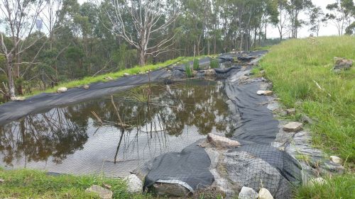
Restoration of the water-holding capacity and connectivity of bell frog habitat in the Brickpit and Kronos Hill has been improved with temporary ponds being created with tarps (Fig 2). The aim is twofold – to extend the number of predator-free, drought refuges, important for adult female frogs and metamorphs and to ensure frog corridors maintain connectivity.  More than 10 tarp ponds have been created and have an expected life span of 3-6 years and are very budget friendly. Annual monitoring has shown a remarkable uptake of these ponds by the Green and Golden Bell Frog.

Figure 2.  Tarp pond with netting

Further results to date. The Parks ecological monitoring program is ongoing and now entering the 16th consecutive year for birds, 15th for reptiles and 21 years for the Green and Golden Bell Frog. In 2018-19 the fourth woodland bird survey was completed, a four yearly assessment of the status of woodland birds and vegetation management at Sydney Olympic Park. Fifteen quadrats are surveyed over the spring and autumn seasons to measure bird communities which is then compared to change in vegetation structure. Results show that small birds were strongly, positively correlated with shrub cover, but strongly negatively correlated with tree cover and Noisy Miner (Manorina melanocephala).  Since 2006, Sydney Olympic Park Authority has implemented a habitat modification program aimed at increasing the structural diversity and complexity of key areas of the Park to support woodland birds. The program seeks to build connectivity between key woodland bird habitats with the form of habitat enhancement varying depending on site characteristics. The survey shows that this program is successfully creating suitable habitat for this group of birds.

With the prospect of greater demands by the public to access the Park at all hours (see below), Sydney Olympic Park staff have recently collected baseline light level readings from across the Park to inform decision making.  Data on lux levels and light source was collected from over 160 sites ranging from car parks to mangrove creeks. The main drive of the survey was to collect information on light spill into sensitive habitat areas where darkness is a key ecological feature. The survey led to a review of lighting and identification of where lights could be switched off or timed to decrease light impacts. The findings will also inform future planning for illumination within the Park.

Lessons learned and future directions. Sydney Olympic Park is part of a rapidly densifying area with the 30,000 residents currently located within a 3km radius forecast to increase to approximately 100,000 in ten years. Due to the density of housing, Sydney Olympic Park will be/is already the local park for this community, leading to increasing demand for recreation and access to the Parklands. This presents great opportunities for more people to connect with nature and to incorporate community education and sustainability into Park programs.  A new program known as Park Care has been launched recently and currently rolls out community clean up and revegetation activities.

The flipside of this rapid population increase is increasing risk of disturbance to ecologically sensitive areas which needs to be considered and mitigated carefully as the Park continues to evolve. Ensuring the Park is able to sustainably meet this demand is a focus for management now and into the future. New habitat management plans for ecologically sensitive areas of the Park are being developed to better-guide biodiversity conservation on a precinct level. Ongoing ecological management works, and managing the impacts of human disturbance, will be essential to conserving the ecological values of the Park.

Contact. Jennifer O’Meara, Parklands Ecologist, Sydney Olympic Park Authority, 5 Olympic Boulevard, Sydney Olympic Park 2127 NSW, Australia. Email: Jenny.omeara@sopa.nsw.gov.au

Recovering Murray-Darling Basin fishes by revitalizing a Native Fish Strategy – UPDATE of EMR feature

John Koehn, Mark Lintermans and Craig Copeland

[Update of EMR Feature: Koehn JD, Lintermans M, Copeland C (2014) Laying the foundations for fish recovery: The first 10 years of the Native Fish Strategy for the Murray‐Darling Basin, Australia. Ecological Management & Restoration, 15:S1, 3-12. https://onlinelibrary.wiley.com/doi/10.1111/emr.12090]

Key words restoration, native fish populations, threatened species, Australia, Murray-Darling Basin

Figure 1. The construction of fishways can help restore river connectivity by allowing fish movements past instream barriers. (Photo: ARI.)

 Introduction. Fish populations in the Murray-Darling Basin (MDB), Australia, have suffered substantial declines due to a wide range of threats and there is considerable concern for their future. Given these declines and the high ecological, economic, social and cultural values of fish to the Australian community, there is a need to recover these populations. In 2003, a Native Fish Strategy (NFS) was developed to address key threats; taking a coordinated, long-term, multi-jurisdictional approach, focussed on recovering all native fish (not just angling species) and managing alien species. The strategy objective was to improve populations from their estimated 10% of pre-European settlement levels, to 60% after 50 years of implementation.

To achieve this the NFS was intended to be managed as a series of 10-year plans to assist management actions in four key areas; the generation of new knowledge, demonstration that multiple actions could achieve improvements to native fish populations, building of a collaborative approach, and the communication of existing as well as newly-acquired science. The NFS successfully delivered more than 100 research projects across six ‘Driving Actions’ in its first 10 years, with highlights including the implementation of the ‘Sea to Hume’ fishway program (restoring fish passage to >2 200 km of the Murray River, Fig 1), improved knowledge of fish responses to environmental water allocations, development of new technologies for controlling alien fish, methods to distinguish hatchery from wild-bred fish, creating a community partnership approach to ‘ownership’ of the NFS, and rehabilitating fish habitats using multiple interventions at selected river (demonstrations) reaches.  The NFS partnership involving researchers, managers, policy makers and the community delivered an applied research program that was rapidly incorporated into on-the-ground management activities (e.g. design of fishways; alien fish control, environmental watering; emergency drought interventions). The NFS largely coincided with the Millennium Drought (1997-2010) followed by extensive flooding and blackwater events, and its activities contributed significantly to persistence of native fish populations during this time.

Funding for the NFS program ceased in 2012-13, after only the first decade of implementation but the relationships among fishers, indigenous people and government agencies have continued along with a legacy of knowledge, development of new projects and collaborative networks with key lessons for improved management of native fishes (see http://www.finterest.com.au/).

Figure 2. Recreational fishers are a key stakeholder in the Murray-Darling Basin, with a keen desire to have sustainable fishing for future generations. (Photo: Josh Waddell.)

Further works undertaken. Whilst the NFS is no longer funded as an official project, many activities have continued though a range of subsequent projects; some are highlighted below:

  • Environmental water: development of fish objectives and implementation of the Basin Plan, northern MDB complementary measures, further investigation of mitigation measures for fish extraction via pumps and water diversions.
  • Fishways: Completion of sea to Lake Hume fishway program and other fishways such as Brewarrina
  • Community engagement: Continuation of many Demonstration (recovery) reaches and intermittent NFS Forums (Fig 2).
  • Recreational fishery management: engagement of anglers through the creation of the Murray Cod (Maccullochella peelii) fishery management group and OzFish Unlimited.
  • Threatened species recovery: success with Trout Cod (Maccullochella macquariensis)  (Fig 3) and Macquarie Perch (Macquaria australasica) populations, development of population models for nine MDB native fish species.
  • Knowledge improvement: research has continued, as has the publication of previous NFS research-related work.
  • Indigenous and community connection to fishes: development of the concept of Cultural flows, involvement in Basin watering discussions.

Figure 3. Trout Cod are a success story in the recovery of Australian threatened species. (Photo: ARI.)

Further results to date. The continued poor state of native fishes means there is a clear need for the continuation of successful elements of the NFS. There is need, however, for revision to provide a contemporary context, as some major changes have occurred over the past decade. The most dramatic of these, at least publicly, has been the occurrence of repeated, large fish kills (Fig 4). This was most evident in the lower Darling River in early 2019 when millions of fish died. The media coverage and public outcry followed the South Australian Royal Commission and two ABC 4Corners investigations into water management, highlighted that all was not well in the Murray-Darling Basin. Indeed, following two inquiries, political recommendations were made to develop a Native Fish Recovery Management Strategy (NFMRS), and a business case is currently being developed. The drought, water extraction and insufficient management efforts to support native fish populations, especially within a broader sphere of a ‘new’ climate cycle of more droughts and climatic extremes, have contributed to these fish kill events. For example, one of the necessary restoration efforts intended from the Basin Plan was to provide more water for environmental purposes to improve river condition and fish populations. Recent research, however, appears to indicate that flow volumes down the Darling River have generally decreased. There is also a continuing decline of species with examples such as Yarra Pygmy Perch (Nannoperca obscura), now being extinct in MDB, and the closely related Southern Pygmy Perch (Nannoperca australis) which is still declining. Monitoring of fish populations has indicated that they remain in poor health and the need for recovery may be even greater than in 2003. We need to act now.

While some of the legacy of the NFS has continued, there has been a loss of integrated and coordinated recovery actions that were a key feature of the NFS. This loss of a Basin-wide approach has resulted in some areas (e.g. small streams and upland reaches) being neglected, with a concentration on lowland, regulated river reaches. There has also been a shift from a multi-threat, multi-solution approach to recovery, to a narrower, flow-focussed approach under the Basin Plan. In addition, there has been the installation of infrastructure (known as Sustainable Diversion Measures) to ‘save’ water which may have deleterious impacts on fish populations (e.g. the impoundment of water on floodplains by regulators or the changed operations of Menindee Lakes on the Darling River).

A clear success of the NFS was improvements in community understanding of native fishes and their engagement in restoration activities. These community voices- indigenous, conservation, anglers, etc. have been somewhat neglected in the delivery of the Basin Plan. There has been ongoing fish researcher and stakeholder engagement, but this has been largely driven by enormous goodwill and commitment from individuals involved in the collaborative networks established through the NFS. While these efforts have been supported by many funding bodies and partners such as the Murray-Darlin Basin Authority, state and Commonwealth water holders and agencies and catchment management authorities, without true cross-basin agreement and collaboration the effectiveness of these efforts will be significantly reduced.

Figure 4. Fish kills have created great public concern and are an indication of the need for improved management of native fish populations. (Photo:Graeme McRabb.)

Lessons learned and future directions.  Native fish populations in the MDB remain in a poor state and improvements will not be achieved without continued and concerted recovery efforts. Moreover, a 5-year review of the NFS indicated that while the actions undertaken to that time had been positive, they needed to be a scaling up considerably to achieve the established goals.  Recovery actions must be supported by knowledge and the lessons learnt from previous experience.  Some fish management and research activities have continued under the auspices of the Basin Plan, but these have largely focussed on the delivery of environmental water, either through water buy-backs or improved efficiency of water delivery. A key requirement is therefore transparent and accurate measurement and reporting of how much flow has been returned to the environment, and how this may have improved fish populations. This remains problematic as evidenced by the recent inquiries into fish kills in the lower Darling River (and elsewhere) and the lack of available water accounting. Fish kills are likely to continue to reoccur and the lingering dry conditions across much of the Northern Basin in 2018-19 and climate forecasts have highlighted the need for further, urgent actions through an updated NFS.

The NFS governance frameworks at the project level were excellent and while some relationships have endured informally, there is a need for an overarching strategy and coordination of efforts across jurisdictions to achieve the improved fish outcomes that are required. The absence of the formal NFS thematic taskforces (fish passage, alien fishes, community stakeholder, demonstration reaches etc) and the absence of any overarching NFS structures means that coordination and communication is lacking, with a focus only on water, limiting the previously holistic, cross jurisdiction, whole-of-Basin approach. The priority actions developed and agreed to for the NFS remain largely relevant, just need revitalized and given the dire status of native fish, scaled up significantly.

Stakeholders and funding. The continuation of quality research and increased understanding of fish ecology, however, not have kept pace with the needs of managers in the highly dynamic area of environmental watering. The transfer of knowledge to managers and the community needs to be reinvigorated. Efforts to engage recreational fishers and communities to become stakeholders in river health are improving (e.g. OzFish Unlimited: https://ozfish.org.au; Finterest website: http://www.finterest.com.au/) but with dedicated, increased support, a much greater level of engagement would be expected.  Previously, the community stakeholder taskforce and Native Fish coordinators in each state provided assistance and direction, including coordination of the annual Native Fish Awareness week. Some other key interventions such as the Basin Pest Fish Plan have not been completed and recovery of threatened fishes have received little attention (e.g. no priority fish identified in the national threatened species strategy).  Funding for fish recovery is now piecemeal, inadequate and uncoordinated, despite the growing need. The $13 B being spent on implementation of the Basin Plan should be complemented by an appropriate amount spent on other measures to ensure the recovery of MDB fishes.

Contact information. John Koehn is a Principal Research Scientist at the Arthur Rylah Institute for Environmental Research, Department of Environment, Land, Water and Planning, was an author the Murray-Darling Basin Native Fish Strategy and a member of various Native Fish Strategy panels and projects (Email:  John.Koehn@delwp.vic.gov.au). Mark Lintermans is an Associate Professor at Institute for Applied Ecology, University of Canberra, and was a member of various Native Fish Strategy panels and projects; (Email: Mark.Lintermans@canberra.edu.au). Craig Copeland is the CEO of OzFish Unlimited and a leading contributor to the development of the next stage of the Native Fish Strategy, the Northern Basin Complementary Measures Program and the 2017 MDB Native Fish Forum (Email: craigcopeland@ozfish.org.au).


Long-term restoration in the Box Gum Woodlands of south-eastern Australia – UPDATE of EMR feature

David Lindenmayer, Mason Crane, Daniel Florance, David Smith, and Clare Crane

[Update of EMR feature –   Lindenmayer, David, Emmo Willinck, Mason Crane, Damian Michael, Sachiko Okada, Chris Cumming, Kylie Durant and Judy Frankenberg (2013) Murray Catchment habitat restoration: Lessons from landscape-level research and monitoring. Ecological Management & Restoration, 14:2, 80-92.  https://onlinelibrary.wiley.com/doi/abs/10.1111/emr.12051 ]

Keywords: Revegetation, biodiversity recovery, monitoring, birds

Figure 1. Revegetated woodland near Wagga Wagga in the South West Slopes of New South Wales. (Photo courtesy of the Sustainable Farms project at The Australian National University. Australia).

Introduction

This project encompasses a major set of large-scale, long-term integrated studies quantifying the response of various groups of biota to replanted woodlands in the Box Gum Grassy Woodlands of south-eastern Australia. The work has been underway since 2002 and contrasts revegetated areas with regrowth woodlands and old growth woodlands on multiple farms nested within landscapes with varying amounts of native vegetation cover (Fig 1.). The responses of birds, arboreal marsupials, terrestrial mammal, reptiles, frogs and native plants to these different kinds of broad vegetation types (and within-site and landscape-level attributes) have been documented over the past 17 years.

Further works undertaken

Since the inception of the original project and associated monitoring, an array of additional studies have been completed (https://www.anu.edu.au/about/strategic-planning/sustainable-farms). These include investigations of the impacts on birds and reptiles of livestock grazing in plantings, the benefits for birds of understorey plantings within old growth woodlands, the impacts of a control program for the Noisy Miner (Manorina melanocephala) on other woodland bird species, and interaction effects between long-term climate, short-term weather and revegetation programs on birds (Figs 2 and 3). Further work aims to quantify the biodiversity and livestock production benefits of enhancing the ecological condition (and associated water quality) of farm dams.

Figure 2. Flame Robin and Rufous Whistler – two bird species of conservation concern that respond positively to revegetated woodland. (Photos by Robin Patrick Kavanagh.)Further results to date

Research and monitoring in the past six years have resulted in a number of key new insights of considerable importance for restoration programs. A small subset of these findings includes:

  • The conservation benefits of replanted areas for bird and reptile biodiversity are undermined by intensive livestock grazing in these revegetated areas.
  • The bird biodiversity values of old growth temperate woodlands can be enhanced by underplantings of shrubs and other non-overstorey plants, although it can take many years for such benefits to manifest. Importantly, the occurrence of hyper-aggressive species such as the Noisy Miner is diminished in woodlands where underplantings have been established.
  • Experimental efforts to reduce populations of the Noisy Miner were largely unsuccessful; sites where this species was culled twice were rapidly recolonized by the Noisy Miner.
  • Replanted woodlands provide critical refugia for woodland birds, especially during prolonged drought periods.

Collectively, these findings indicate that restored woodlands have important conservation values (especially for birds but also reptiles), with restoration being valuable to conduct not only in existing old growth woodland (through establishing underplantings) but also in previously cleared sites. The conservation value of woodlands can be particularly critical during climate extremes such as droughts. Efforts to control the Noisy Miner will likely be most effective through targeted revegetation efforts rather than direct culling of birds. Finally, there is a need to limit grazing pressure in revegetated woodlands and this can require the repair or replacement of fences around replantings, especially when such key infrastructure begins to deteriorate.

Figure 3. Noisy Miner – a reverse keystone species for which experimental culling programs have proven to be ineffective. (Photo by Pete Richman.)

Lessons learned and future directions

The ongoing work has clearly demonstrated the important new insights that are derived from long-term ecological research and monitoring. Indeed, long-term changes in patterns of occupancy of restored areas could not have been quantified without rigorous monitoring of a wide range of sites of different sizes, ages and other attributes. Key manager-researcher partnerships have been fundamental to the ongoing success of the array of projects in this restoration initiative. Indeed, some research and monitoring studies were prompted by  questions posed by natural resource managers (such as if there were vegetation cover thresholds for birds in temperate woodlands). Close working relationships with farmers have also been critical to the persistence of the various projects. Field staff in the project, who are based permanently in rural Australia, are key points of outreach and communication with farmers and other natural resource managers. Their presence has accelerated the rate of knowledge transfer and adoption of new practices (such as widening shelterbelts so that they have multiple production and conservation values).

Stakeholders and funding bodies

Ongoing work has been supported by many funding bodies and partners. These include the owners of more than 250 private properties (whom have allowed access to their land and undertaken major restoration works). Funding for the work has been provided by The National Environmental Science Program (Threatened Species Recovery Hub), the Australian Research Council, Murray Local Land Services, Riverina Local Land Services, Central Tablelands Local Land Services, the Ian Potter Foundation, the Vincent Fairfax Family Foundation, The Australian National University, and the Calvert-Jones Foundation.

Contact information

David Lindenmayer, Sustainable Farms Project, Fenner School of Environment and Society, The Australian National University, Canberra, ACT, 2601, david.lindenmayer@anu.edu.au

Restoration and conservation in an iconic National Park – UPDATE of EMR feature

David Lindenmayer, Chris MacGregor, Natasha Robinson, Claire Foster, and Nick Dexter

[Update of EMR feature – David B. Lindenmayer, Christopher MacGregor, Nick Dexter, Martin Fortescue and Peter Cochrane (2013)  Booderee National Park Management: Connecting science and management.  Ecological Management & Restoration, 14:1, 2-10. https://onlinelibrary.wiley.com/doi/10.1111/emr.12027]

Keywords: Invasive animal and plant control, reintroduction, monitoring

Introduction. Booderee National Park is an iconic, species-rich, coastal reserve that supports a range of threatened and endangered native animals and plants. Several key management actions have been implemented to promote the conservation of biodiversity in Booderee National Park. These include the control of an exotic predator (the Red Fox Vulpes vulpes), the control of highly invasive Bitou Bush (Chrysanthemoides monilifera subsp. rotundata), the management of fire, and the reintroduction of previously extinct native mammals. A key part of work at Booderee National Park has been a long-term monitoring program that commenced in late 2002 and which has aimed to quantify the effectiveness of major management interventions, including the four listed above. The monitoring program has documented the long-term trajectories of populations of birds, arboreal marsupials, terrestrial mammals, reptiles, frogs and native plants in a range of major vegetation types (from heathland and sedgeland to woodland, forest and rainforest) and in response to fire, and weed and feral predator control. Importantly, the monitoring program has provided a foundational platform from which a suite of post-graduate studies and other research programs have been completed.

Further works undertaken. A key part of the researcher-manager partnership has been to analyse the long-term trajectories of populations of mammals, birds and reptiles in Booderee National Park. The monitoring data indicate that many species of mammals are declining, with some having become recently locally extinct (e.g. Greater Glider Petauroides volans) or close to extinction in the reserve (e.g. Common Ringtail Possum Pseudocheirus peregrinus) . This is despite populations of these species persisting in nearby reserves.  Robust interrogation of the multi-taxa monitoring data has been unable to identify reasons for these declines. Interestingly, the declines observed for mammals have not been observed to date in other vertebrate groups, including birds, reptiles and amphibians. An experimentally-based reintroduction program for the Greater Glider aims to not only re-establish populations of the species in Booderee National Park, but also to identify the reasons for the original decline. That program will be in addition to reintroduction programs already underway for other mammal species, the Long-nosed Potoroo (Potorous tridactylus), the Southern Brown Bandicoot (Isoodon obesulus) and Eastern Quoll (Dasyurus vivverinus) that used to inhabit Booderee National Park but which went extinct many decades earlier.

Additional research being undertaken in Booderee National Park has included: (1) studies of the effectiveness of control efforts for Bitou Bush and associated recovery of native vegetation and native fauna, (2) the interactive effects of fire and browsing on native plants and an array of animal groups, and (3) studies of leaf litter and other fuel dynamics in relation to previous fire history and macropod browsing.

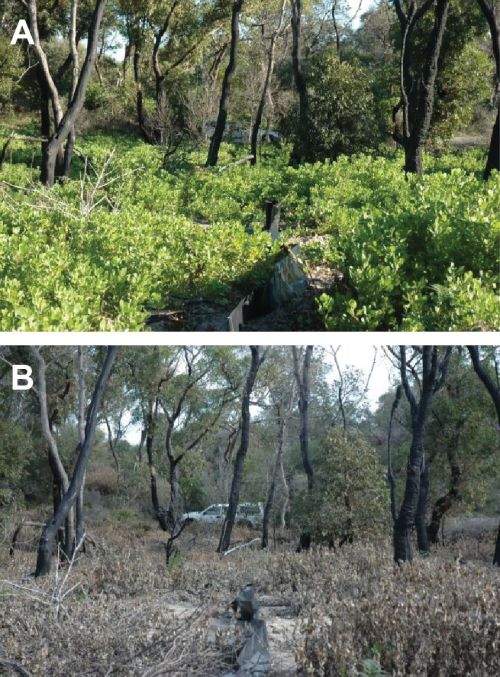
Figure 1. Key area of Booderee National Park showing an area of coastal forest before and after Bitou Bush treatment.

Further results to date. Research and monitoring in the past six years have resulted in many new insights including some of considerable value for informing restoration programs. A small subset of these findings is outlined below.

  • Conventional approaches to the control of invasive Bitou Bush entail spraying ultra-low volume herbicide (Fig. 1), followed by burning of the “cured” dead material, and then respraying of the seedlings that germinate after fire. This spray-burn-spray protocol is both the most ecologically effective and the most cost-effective way of controlling Bitou Bush and, at the same time, facilitates the recovery of native vegetation. More recent analysis has revealed spray frequency as the most important determinant of long-term control. There are mixed effects of control methods on native species; plant species abundance was positively related to Bitou Bush control, while native bird abundance (except for Eastern Bristlebird Dasyornis brachypterus, Fig 2.) and mammal abundance were weakly negatively associated with Bitou control.
  • There can be strong interactions between the occurrence of fire and browsing by macropods on native plants as well as particular groups of animals such as spiders.
  • Reintroduction programs for the Southern Brown Bandicoot and Eastern Quoll have been relatively successful, although the latter species suffers high rates of mortality, particularly as a result of fox predation and collisions with motor vehicles. Nevertheless, populations of both species have survived over multiple years and reproduced successfully.

Figure 2. The Eastern Bristlebird, a species for which Booderee National Park is a stronghold. Notably, the species responds positively to management interventions to control Bitou Bush. (Photo Graeme Chapman)

Lessons learned and future directions. The work at Booderee National Park is a truly collaborative partnership between reserve managers, a university and the local Indigenous community.  A key part of the enduring, long-term success of the project has been that a full-time employee of The Australian National University has been stationed permanently in the Parks Australia office in the Jervis Bay Territory. That person (CM) works on an almost daily basis within Booderee National Park and this provides an ideal way to facilitate communication of new research and monitoring results to managers. It also enables emerging management concerns to be included as part of adaptive monitoring practices.

One of the key lessons learned from the long-term work has been the extent of ecological “surprises” – that is, highly unexpected results, including those which continue to remain unexplained. An example is the rapid loss of the Greater Glider and the major decline in populations of the Common Ringtail Possum. One of the clear benefits of this integrated monitoring-management team has been the rapid response to emerging threats. For example in response to high rates of mortality of reintroduced Eastern Quolls, control of the Red Fox was intensified within the park and greater cross-tenure control efforts with neighbouring private and public land managers have commenced. Regular evaluation of monitoring data and management actions has also enabled careful examination of the kinds of risks that can compromise reintroduction programs. These and other learnings will inform other, future reintroduction and translocation programs that are planned for Booderee National Park such as that for the Greater Glider.

Stakeholders and funding bodies. Ongoing work has been supported by many funding bodies and partners. These include the Wreck Bay Aboriginal Community who are the Traditional Owners of Booderee National Park as well as Parks Australia who co-manage the park with the Wreck Bay Aboriginal Community. Other key funders include the Department of Defence, the Thomas Foundation, The National Environmental Science Program (Threatened Species Recovery Hub), the Australian Research Council, the Margaret Middleton Foundation, and the Norman Wettenhall Foundation. Partnerships with Rewilding Australia, Taronga Conservation Society, WWF Australia, NSW Forestry Corporation and various wildlife sanctuaries have been instrumental to reintroduction programs.

Contact information. David Lindenmayer, Chris MacGregor, Natasha Robinson and Claire Foster are with the National Environmental Science Program (Threatened Species Recovery Hub), Fenner School of Environment and Society, The Australian National University (Canberra, ACT, 2601, david.lindenmayer@anu.edu.au). Nick Dexter is with Parks Australia, Jervis Bay Territory, Australia, 2540.

Lord Howe Island biodiversity restoration and protection programs, NSW, Australia

Hank Bower

Key words: Pest species management, weed control, community engagement.

Figure 1. Weeding teams apply search effort across near 80% of island terrain, their effort monitored through record of GPS track logs across designated weed management blocks. Target weeds on LHI are mostly bird dispersed requiring landscape scale for sustainable and long-term protection from weeds. The remaining 20% of island is subject to surveillance and with investigation of new technical approaches in weed detection using drones.

Introduction: Lord Howe Island (LHI) is located in the Tasman Sea 760 km northeast of Sydney and 570 km east of Port Macquarie. In 1982 the island was inscribed on the World Heritage (WH) List under the United Nations’ World Heritage Convention in recognition of its superlative natural phenomena and its rich terrestrial and marine biodiversity as an outstanding example of an island ecosystem developed from submarine volcanic activity.

The island supports at least 80% cover of native vegetation, broadly described as Oceanic Rainforest with Oceanic Cloud Forest on the mountain summits.  LHI vegetation comprises 239 native vascular plant species with 47% being endemic. Forest ecosystems on LHI are largely intact, but at threat from invasive species and climate change. About 75% of the terrestrial part of the WH property is recognised as a Permanent Park Preserve (PPP) managed on behalf of the New South Wales government by the Lord Howe Island Board on the basis of a holistic conservation and restoration plan (Lord Howe Island Biodiversity Management Plan LHI BMP 2007).

Since settlement of the island in 1834, introduced and invasive plant and animal species have been affecting the Lord Howe Island environment, causing declines in biodiversity and ecosystem health. There have been 11 known extinctions and severe declines in numbers of fauna species including the flightless Lord Howe Woodhen (Hypotaenidia sylvestris), once regarded as one of the rarest birds in the world.  The Lord Howe Island Phasmid (Dryococelus australis), the world’s largest stick insect was feared extinct until the rediscovery of live specimens on Balls Pyramid in 2001. Some 29 species of introduced vertebrates and about 271 species of introduced plant species have naturalised on the island. At least 68 species are the focus for eradication (Fig 1), with 10 main invasive species having colonised extensive areas of the settlement and the PPP, posing a serious threat to island habitats. One of the most serious weeds, Ground Asparagus (Asparagus aethiopicus), for example, was so prolific in the forest understory it completely overwhelmed native vegetation and bird breeding grounds. Weeds are prioritised for eradication following a Weed Risk Assessment and are typically species that are at low density, are localised and/or are limited to gardens, and species with known weed characteristics (e.g. wind or bird dispersed seeds) that have yet to express their weed potential. Identifying species for early intervention is important to prevent their establishment and expansion, particularly post rodent eradication. For example, the removal of 25 individual Cats Claw Creeper in 2006 (which have not been detected since) supports the case for proactive weed management.

The islands limited size and isolation provides great opportunities to achieve complete removal and eradication of key invasive species.  Therefore particular strategies identified in the LHI BMP to effect ecosystem recovery include the management and eradication of invasive weeds, rodents, tramp ants and protection from plant diseases and pathogens.  All projects are delivered at an island wide scale, which incorporates a permanent population of 350 residents and a tourist bed limit of 400.

Works undertaken   Progressive programs to eradicate feral animals commenced in 1979 with the eradication of pig Sus scrofa, cat Felus catus in 1982, goat Capra hircus in 1999 and African Big-headed Ant Pheidole megacephala in 2018. Threatened fauna recovery programs include the captive breeding of Lord Howe Woodhen following the eradication of cats, establishing a captive breeding and management program for the Lord Howe Island Phasmid and the planning and gaining of approvals to implement the eradication program for Black Rat Rattus rattus, House Mouse Mus musculus and introduced Masked Owl Tyto novehollandiae commencing in 2019.

The island wide strategic Weed Eradication Program commenced in 2004, building on earlier years of ad-hoc control effort.  Over 2.4 million weeds have been removed through more than 170,000 hours of grid search method.  Now, near mid-way point of a 30-year LHI Weed Eradication Project (LHIWEP), teams have reduced weed infestations (of all life stages) by 80%.  Ten year program results of the LHIWEP are summarised (LHIB 2016 – Breaking Bad) http://www.cabi.org/isc/abstract/20163360302, which clearly shows the significance of multi-invasive species management to achieve ecosystem recovery.

With the spread of Myrtle Rust Austropuccinia psidii to the Australian mainland in 2010 the LHI Board has been on high alert.  With five endemic plants at risk to this pathogen the LHIB provided training and information to the community on the threats to the island and food plants. The LHIB prepared a Rapid Response Plan and a Rapid Response Kit (fungicides and Personal Protective Equipment). In October 2016 Myrtle Rust was detected on exotic Myrtaceae species, from three leases and subsequently treated in November 2016. This also resulted in the eradication of three highly susceptible exotic myrtaceous plant species from the island.

The root fungus Phytophthora cinnamomi is known from one lease and has been quarantined and treated with granular fungicide quarterly. Periodic monitoring has shown the infestation to be reducing with the eventual aim of eradication. Boot sanitization stations located at all track heads applies effort to prevent introduction of root rot fungus and other soil borne pathogens from users of the walking track system in the PPP.

The LHI Board has carried out a range of local community engagement and visitor education programs to raise awareness of the risks and threats to the island environment and of the LHIB environmental restoration and protection programs. These include a LHI User Guide for visitors to the island and a citizen science program with the LHI Museum, establishing the LHI Conservation Volunteer program to help improve awareness of the importance of LHI conservation programs to both tourists and tourism business. Since 2005, over 150 volunteers supported by the LHIB and external grants have been engaged through the weed eradication project. Increasingly, LHI residents are volunteering to gain experience and to improve employment opportunities in restoring their island. Another long-term partner, Friends of Lord Howe Island, provide invaluable volunteer assistance with their Weeding Ecotours, contributing more than 24,000 hours of weeding building valuable networks.

Biosecurity awareness is critical to protect the investment in conservation programs and the environment to future threats. The LHI Board provide information regarding biosecurity risks to the community, stevedores and restaurateurs. The LHIB now hold two biosecurity detection dogs and handlers on island (Figure 3) whom work with Qantas and freight flights and shipping staff to ensure they are aware of biosecurity risks and plan for appropriate responses.

Results to date.  Achievements include the successful eradication of over 10 weed species, cat, pig, goat, African Big-headed Ant and Myrtle Rust. A further 20+ weeds are considered on the verge of being able to be declared eradicated in coming years with an 80% reduction in weed density island wide and a 90% reduction in the presence of mature weeds. Weed Risk Assessments will be applied to determine the impact or new and emerging weeds and appropriate management actions.

As a result of the eradication of feral pigs and cats and an on-island captive breeding program, the endangered Lord Howe Island Woodhen has recovered to an average of 250 birds. The other eradications, along with the significant reduction in dense and widespread weed invasions, has aided the recovery and protection of numerous endemic and threatened species and their habitats. The program’s significant outcomes have been recognised through the IUCN Conservation Outlook which in 2017 scored the Lord Howe Island Group’s outlook as good, primarily due to the success of projects that have, are being and are planned to be implemented to restore and protect the islands unique World Heritage values. In late 2018 the program received awards for excellence from the Society for Ecological Restoration Australasia (SERA), Green Globe and Banksia Foundations, acknowledging the sustained effort from the Board and Island community in working to restore and protect the island.

Lessons learned and future directions:  The main keys to success has been obtaining expert scientific and management input and actively working with, educating and involving the community (lease holders and local businesses) to help achieve the solution to mitigate and remove invasive species.

The Rodent Eradication Program scheduled for winter 2019 will result in less browsing pressure on both native and invasive plants species, as well as the removal of two domestic pests. Prior to the program the LHIB has targeted the control of introduced plants, currently in low numbers, that may spread after rodent eradication. Monitoring programs are in place to measure ecosystem response with a particular focus on the Endangered Ecological Community Gnarled Mossy Cloud Forest on the summit of Mt Gower. Should the project be successful, consideration can be given to the reintroduction of captive bred individuals of the Lord Howe Island Phasmid as well as other species confined to offshore islands (e.g. Lord Howe Wood Feeding Roach Panesthia lata) or ecological equivalent species on other islands (Norfolk Boobook Owl Ninox novaeseelandiae, Norfolk Parakeet Cyanoramphus cookii, Norfolk Island Grey Fantail Rhipidura albiscapa and Island Warbler Gerygone igata).

Stakeholders and Funding bodies:  The Program is managed by the Lord Howe Island Board and the NSW Department of Environment and Heritage, in collaboration with the local LHI community.

The LHI Board acknowledge the generations of islander stewardship, teams on ground, researchers, the funding and support agencies, all who made it happen. These include but are not limited to NSW Environmental Trust, Caring for Our Country, National Landcare Program, North Coast Local Land Services, Zoos Victoria, Taronga Zoo, Australian Museum, CSIRO, Friends of LHI, the Norman Wettenhall Foundation and Churchill Trust.

Contact: Hank Bower, Manager Environment/World Heritage, Lord Howe Island Board, PO Box 5, LORD HOWE ISLAND, NSW 2898, Tel: +61 2 65632066 (ext 23), Fax: 02 65632127, hank.bower@lhib.nsw.gov.au

Video conference presentation: https://www.aabr.org.au/portfolio-items/protecting-paradise-restoring-the-flora-and-fauna-of-world-heritage-listed-lord-howe-island-hank-bower-and-sue-bower-lhi-board-aabr-forum-2016/

Also see updates of rodent eradication program:

https://lhirodenteradicationproject.org/

https://www.environment.nsw.gov.au/news/rodent-eradication-gives-lord-howe-biodiversity-boom

https://www.abc.net.au/news/2021-02-02/lord-howe-island-recovers-from-rat-infestation/13111770

https://www.theguardian.com/australia-news/2021/apr/19/rats-reappear-on-lord-howe-island-for-the-first-time-since-2019-eradication-program

Motuora Restoration Project, New Zealand

Key Words: Ecological restoration, reintroductions, island restoration, community engagement, Motuora Restoration Society

Motuora Restoration Society (http://motuora.org.nz) is recognised by the New Zealand Department of Conservation as the lead community agency for the restoration of Motuora, an 80 ha island in the Hauraki Gulf, New Zealand.  Since 2003 the Society has taken responsibility for the Island’s day-to-day management as well as developing and implementing the Island’s long term restoration strategy. Our aspiration is summed up in our  statement “It is our dream that future generations will enjoy a forest alive with native birds, reptiles and insects”.

Figure 1 – Aerial view of the Island before planting began. Area to bottom left has been sprayed in preparation for planting (Photo from cover of 2007 Motuora Native Species Restoration Plan).

Figure 1 – Aerial view of the Island before planting began. Area to bottom left has been sprayed in preparation for planting (Photo from cover of 2007 Motuora Native Species Restoration Plan).

 Figure 2 – Aerial view of the Island after completion of the pioneer planting. (Photo by Toby Shanley)


Figure 2 – Aerial view of the Island after completion of the pioneer planting. (Photo by Toby Shanley)

Background. Motuora is located on the east coast of New Zealand’s North Island near Auckland City. Motuora would once have been tree-covered and have hosted a wide range of native plants, invertebrates, reptiles and birds, particularly burrow-nesting seabirds. It was visited by early Polynesian settlers, later Māori, who would have initially camped, but later lived more permanently on the Island raising crops and harvesting fish, shellfish and presumably seabird eggs, chicks and adults. European settlers later occupied the Island, burning off most of the bush to encourage growth of grasses for their grazing livestock.

Towards the end of the farming period in the 1980s most of the Island’s native flora and fauna were gone. Interestingly however, there were never breeding populations of introduced mammalian pests on the Island so the remnant ecosystem had not been impacted by mice, rats, mustelids, hedgehogs, possums, goats, pigs or deer.

From about 1987 onwards both Government and members of the public began to take an interest in the Island and to promote the idea of adopting it as a predator-free bird habitat. Discussions continued over the next few years and by 1992 a sub-committee of the mid-North Royal Forest and Bird Protection Society had been formed and, in partnership with the Department of Conservation, drew up the first ‘strategy plan’ for the Island. Work parties began seed collecting, trial tree planting, weeding and fencing upgrades. By 1995 it had become apparent that the project could best proceed by way of an independent group dedicated to the task and the Motuora Restoration Society was formed.

The work on Motuora was designed to be a true restoration project combining firm ideas about the model ecosystem desired and a ‘bottom-up’ approach (vegetation-invertebrates-reptiles-birds) timing planting and introductions in a logical sequence. The historical presence of species on Motuora was inferred from comparisons with other less modified islands off the north east of the North Island, and particularly those from within the Rodney and Inner Gulf Ecological Districts, and using paleological information collected from the adjacent mainland.  Motuora Restoration Society has resisted the temptation to add iconic attractive species not originally present on the Island which might have raised the profile of the project.

Works carried out. The Society and its volunteers have contributed many thousands of hours to the restoration of the Island since 1995, raising and planting more than 300,000 native seedlings. This was particularly challenging with the logistics of working on an island without a regular ferry service or wharf. The project also included seabird and other species translocations, monitoring, weeding and track maintenance as well as fundraising.

The framework adopted began with reforestation so that appropriate habitat could be reinstated. A nursery was set up and seeds were collected from the Island, from nearby islands and, when necessary, from the mainland. With the exception of some areas of higher ground providing panoramic views from the Island, the land area was prepared (by weed-killing rampant kikuyu grass) and planted with hardy, wind and salt tolerant tree species. Once the trees were established, the canopy closed and sufficient shelter available, less hardy species and those requiring lower light levels were planted among the pioneers.  Today the planting of 400,000 trees of pioneer species is all but complete; and the raising and planting of ‘canopy’ and less hardy species continues.

In terms of fauna, invertebrate populations were surveyed and have been monitored as the forest has matured. One species, Wētāpunga (Deinacrida heteracantha) has been introduced.   Four reptiles have been introduced: Shore Skink (Oligosoma smithi), Duvaucel’s Gecko (Hoplodactylus duvaucelii),  Raukawa Gecko (Woodworthia maculata) and Pacific Gecko (Dactylocnemis pacificus).  One small land bird – Whitehead (Mohoua albicilla) has been translocated with 40 individuals moved to the Island.  Four seabird species have been attracted or translocated to the Island including the Common Diving Petrel (Pelecanoides urinatrix), and Pycroft’s Petrel (Pterodroma pycrofti).

Results. The project has restored Motuora from a pastoral farm (dominated by introduced grasses, weeds and only a small remnant fringe of naturally regenerating native forest) to a functioning native ecosystem, predominantly covered in early succession native forest with an intact canopy.

Initially the population of invertebrates was dominated by grassland species but the range and population size of forest dwellers has now much improved and the invertebrate fauna is now rich and plentiful (although rarer and endangered species are still to be added).  An initial suite of populations of flightless invertebrates remain depauperate.  Whitehead, an insectivorous bird species, has flourished with a current population of several hundred. At this early stage in the introduction of native fauna it is possible to report successful breeding and, for the most part, sufficient survival of initial colonisers of the species introduced to suggest that new populations will be established.  Sound attraction systems have led to initial breeding of Fluttering Shearwater (Puffinus gavia) and Australasian Gannet (Morus serrator).

Partnerships. Management of the Island is shared with the Department of Conservation (DOC) who administer the site on behalf of the Crown. DOC has legal commitments to engage with and act on behalf of the general public and particularly with iwi (Māori) who have generally expressed strong support for the restoration project and are expected to have co-management rights over the Island in the future.

Over the years the combined efforts of DOC staff, University researchers, the committee, thousands of volunteers and a host of donors and sponsors have worked hard to bring the Island to its present state.

Future directions. A sustained effort will continue to be required each year on biosecurity and weeding programmes. It will be many more decades before the forest matures and seabird and reptile populations reach capacity levels and a substantial workload is anticipated in managing and monitoring the emerging ecosystem for many years to come.

Acknowledgements: The success of the project is reinforced by the fact that the Society has maintained a close collaboration with a range of scientists and have inspired the active support and engagement of so many volunteers.  We thank all our inspiring volunteers and the following participating academics and researchers who have contributed to the project over the past ten years: Plants: Shelley Heiss Dunlop, Helen Lindsay (contractor). Reptiles: Marleen Baling (Massey University), Dylan van Winkel (consultant), Su Sinclair (Auckland Council), Manuela Barry (Massey University). Invertebrates: Chris Green (DOC), Robin Gardner-Gee (Auckland University), Jacqueline Beggs (Auckland University), Stephen Wallace (Auckland University). Birds: Robin Gardner-Gee (Auckland University), Jacqueline Beggs (Auckland University), Kevin Parker (Massey University), Richard Griffiths (DOC), Graeme Taylor (DOC), Helen Gummer (DOC contractor). The restoration project has been supported financially though grant aid received from a wide range of funders.

Contact: Secretary, Motuora Restoration Society, Email: secretary@motuora.org.nz; www: http://motuora.org.nz/