Category Archives: Queensland

Rewilding lake edges at Sherwood Arboretum, Queensland

Carole Bristow

Figure 1. The site in 2014, 5 years prior to works, showing the lack of wetland fringing vegetation due to it being regularly brushcut. (Photo Friends of Sherwood Arboretum)

Sherwood Arboretum, 15 hectares in size, contains a collection of planted (specimen) Queensland native trees under the supervision of Brisbane Botanic Gardens. Located in the suburb of Sherwood in Brisbane, the Arboretum has the Brisbane River as its western boundary and there are three small watercourses running both into and out of two lakes, providing habitat for wildlife. Before the development of the Arboretum in 1925, the lakes were a single paperbark swamp with small patches of open water. An early city water main ran across the swamp roughly dividing it in two. In 1975 the water main was covered by rocks and soil to form a causeway/walking path, and the swamp was reshaped to form two open lakes containing three islands. Many species of birds use the lakes, the watercourses, and the Arboretum as a whole, gathering and dispersing according to season or changes in management.

Prior to the commencement of regeneration treatments the edges of the lake were relatively barren (Fig 1), kept in this condition by regular mowing and brushcutting which led to occasional collapses of the edges into the lake.  Close inspection found around 14 natives among the weeds being mowed and brushcut; so the idea came that perhaps the natives could be allowed to grow and protect the edge.  This would also form a natural plant community and potential faunal habitat. Twenty weed species were observed, including Signal Grass (Brachiaria decumbens), Green Panic (Megathyrsus maximus var. pubiglumis), Bahia Grass (Paspalum notatum), Slender Pigeon Grass (Setaria parviflora), Blue Couch (Digitaria didactyla), Blue Billy Goat Weed (Ageratum houstonianium), Creeping Indigo (Indigofera spicata).

Works undertaken. In 2019, agreement was reached to discontinue mowing to the edge and brushcutting, and to trial bush regeneration-style weed management along a manageable portion of the lake edge; that is, both sides of the causeway.  The work was carried out by two members of the Friends of Sherwood Arboretum bushcare group, a Habitat Brisbane bushcare group which is supported by Brisbane City Council.   The two volunteers worked on a weekly basis over 4 years, gradually removing weeds to release native plants.  The technique involved weed removal prior to weed seed shed while allowing natives to seed.  The objective was to reduce weed soil seed banks and recharge native soil seed banks over time.

Figure 2. The north-west corner of the causeway in 2021 showing high density natives, particularly Willow Primrose. (Photo Gordon King)

Results to date. As weed cover declined markedly, natives increasingly reappeared, dominating the site within two years.  At the peak of the site’s recovery, 34 native wetland herbaceous species had returned – many of these in high abundance in particular locations Figs 2-7).  These particularly included Tassle Sedge (Carex facsicularis), Emu Foot (Cullen tenax), Narrrow-leaved Indigo (Indigofera linifolia), Common Rush (Juncus usitatus), Willow Primrose (Ludwigia octovalvis), Slender Knotweed (Persicaria decipiens), Spotted Knotweed (Persicaria strigosa) and Poison Pratia (Lobelia concolor).

Water birds that also graze on land have been observed by the regeneration team to be increasingly using the lake edges – including Purple Swamphen (Porphyrio melanotus), Wood Duck (Chenonetta jubata) (Fig 6), Dusky Moorhen (Gallinula tenebrosa) and Intermediate Egret (Ardea intermedia).  The wetland plant insect life has also increased in the recovered areas.  As a result, the Chequered Swallowtail Butterfly (Papilio demoleus) (Fig. 7) is now seen among the Emu Foot, one of its host plants.

Figure 3. General view with White Eclipta (Eclipta prostrata), Slender Knotweed, Willow Primrose, Commelina (Commelina sp.) and Azolla (Azolla sp.) (Photo Gordon King)

Figure 4. Emu Foot. One of the natives tenaciously surviving even when there was a heavy weed presence. (Insets are of the characteristic five leaflets and the inflorescence.) (Photos Gordon King.)

Figure 5. Diversity of native species is high in some places – such as pictured here where Willow Primrose, Common Reed, White Eclipta, Binung (Christella dentata), Sprawling Bluebell (Wahlenbergia gracilis) and Emu Foot occur in close proximity. The waterlily is the introduced Mexican Waterlily (Nymphaea mexicana) and is controlled from time to time. (Photo Gordon King)

Figure 6. Wood Ducks foraging along the regenerating lake edges. (Photo Gordon King)

Figure 7. Insect life has increased including the Chequered Swallowtail butterfly for which Emu Foot is a host plant. (Photo Gordon King)

Changes over time. Composition has proven to be seasonally variable. At one point when the water had reduced to a very low level in the lake, muddy edges appeared, and Bacopa (Bacopa monniera.) emerged and flowered. A few days later there was rain and the water rose and covered the flowering plants – which are unlikely to return until muddy edges reappear. More recently, with heavy rains in February 2022, floodwaters covered all the banks to a depth of over 1m for several days.  Many species were severely affected, particularly Willow Primrose.  However a good recovery of all species is occurring.

A notable result of the work has been that the lake edges are no longer eroding and it is clear that valuable new habitat has been created.  These results provide more positive options for future management of the more extended lake edge should habitat restoration be undertaken in the future. It is an inspiring project to be involved in.

Acknowledgements: Brisbane Botanic Gardens and Brisbane City Council Habitat Brisbane program for agreeing to try this process. The Habitat Brisbane program also helped with occasional contractor support. Also thanks are extended to Gordon King, for his unflagging effort as fellow worker and for the use of his photographs.

Contact: Carole Bristow, bushcare leader, Friends of Sherwood Arboretum bristowc@bigpond.net.au

Second trial of watering device design to facilitate seed dispersal into revegetation sites

Amanda Freeman

Figure 1. Watering device on stand with camera above.

Introduction. This summary reports on methods and results of a trial to improve the design of a watering device. (See preliminary trial in EMR summary). This trial drew upon lessons learned In the “Kickstart” pasture conversion project,  (see https://authors.elsevier.com/a/1bhz81L%7EGwOHhQ) where perches and water basins were installed on two private properties in the upper Barron, Queensland, with the aim of catalysing rainforest regeneration.  The seeds of 31 species of bird-dispersed forest trees and shrubs were deposited in water basins, largely due to Pied Currawong (Strepera graculina) using the water to regurgitate seeds. The Kickstart Project demonstrated that there is potential for supplementary water to enhance seed dispersal into revegetation sites; however, the seeds regurgitated into basins in that study were not deposited in sites suitable for germination, limiting the basins’ usefulness as restoration tools.

Our 2016 EMR Project Summary described a watering device designed to overcome this problem of seed being deposited in water receptacles.  The trial was conducted at the School for Field Studies property near Yungaburra, Queensland and this summary reports the results of our trial which aimed to identify whether frugivorous birds would use our watering device. We also assessed the amount of maintenance the watering device required to function effectively.

Figure 2. A Lewin’s Honeyeater (Meliphaga lewinii) at a watering device, May 2017.

Watering Device Trial. In July 2016, three 3 x 3m plots were established in an approximately 120 x 30m area of disused pasture at the School for Field Studies property. The site was located 15m from the edge of primary rainforest on one side and adjacent to a mosaic of scattered trees, restoration plantings and secondary forest on the other three sides. Each plot had a perch, 3-4m high, cut to standard form from Sarsaparilla (Alphitonia petriei) trees. Each plot also had a watering device placed close to the base of the perch. These were commercially available automatic water dispensers used for poultry set on a 1.5m high base with a perch that allowed birds of different sizes to access water from several angles and for expelled seed to fall to the ground (Figs. 1-3).

Motion-activated cameras (Ranger Compact 2 MP) were installed above each watering device to monitor visits to the water. Apart from a total of 37 days when the cameras were removed for maintenance, the three watering devices were monitored from 22 July 2016 to 13 December 2018 when the trial ended. In the analysis, continuous series of images of one or two birds at a watering device were treated as one visit by that species.

The three plots with a perch and watering device were interspersed with plots that only had a perch or had no structures at all. Apart from within the plots and a narrow access track between them, grass and woody vegetation were not controlled in the surrounding disused pasture.

Figure 3. A Victoria’s Riflebird (Ptiloris victoriae) at a watering device, October 2016.

What we found. Eighty-six visits by three frugivorous bird species were recorded across the three watering devices over the course of the trial. Ninety percent of visits were during the late dry seasons (September-November). One watering device was visited much more often than the others, receiving 70% of all visits. The other two watering devices received 20% and 10% of visits respectively (Table 1).

One bird species, the generalist Lewin’s Honeyeater (Meliphaga lewinii), was by far the most frequent visitor to the watering devices, making up 80% of frugivore visits (Fig. 2). Victoria’s Riflebird (Ptiloris victoriae) was the next most frequent visitor (14% of visits, Fig. 3) and Little Shrikethrush (Colluricincla megarhyncha) was the least frequent visitor (6% of frugivore visits). The only other species that used the watering devices was the Olive-backed Sunbird (Nectarinia jugularis) for which five visits were recorded. All species were recorded drinking from the watering devices. Only the Olive-backed Sunbird could bathe in the small water outlets and were recorded doing so on three occasions.

The watering devices required little maintenance over the 2.5yrs they were deployed. Water was replenished when needed at roughly six-monthly intervals and the water outlets, which collected debris and algae, were cleaned monthly. The devices had no noticeable deterioration at the end of the study.

Table 1. Number of frugivorous bird visits to three watering devices in disused pasture, 22 July 2016 to 13 December 2018.

  1 2 3 Total
Lewin’s Honeyeater Meliphaga lewinii 51 8 10 69
Victoria’s Riflebird Ptiloris victoriae 6 0 6 12
Little Shrikethrush Colluricincla megarhyncha 3 1 1 5
Frugivorous bird visits 60 9 17 86

Conclusions. Our watering devices were only used by three frugivorous bird species, most frequently by the Lewin’s Honeyeater a dietary generalist. Generalist avian frugivores tend to move mainly in more open habitats enhancing the dispersal of pioneer or non-forest trees across the landscape rather than carrying seeds from remnant forest into pasture.

Bird use of the watering devices was highly variable and largely confined to the late dry season when rainfall is low, and temperatures are warm to hot. These are poor conditions for germination and plant growth and likely limit recruitment of dispersed seeds.

Despite these limitations, watering devices are a low-cost intervention that may augment perches and attract frugivorous birds, thereby accelerating forest regeneration. The watering devices deployed in this trial did not collect seed, preserving the potential for seed to be dispersed. They required little maintenance and proved suitable for prolonged outdoor use. Watering devices warrant further investigation. 

Acknowledgements. Thanks to William (Bill) Johnson and John Hall for designing the watering device stand and camera attachment and preparing and maintaining the plots. The School for Field Studies funded the trial.

Contact. Amanda N. D. Freeman. Nature North, PO Box 1536, Atherton, Qld, 4883 Australia. The School for Field Studies, Centre for Rainforest Studies (PO Box 141, Yungaburra, Qld 4884 Australia; Tel: +61 (0) 438 966 773; Email: amandafreeman@naturenorth.com.au).

See also EMR project summary on the preliminary trial of this project: https://site.emrprojectsummaries.org/2016/11/02/a-water-point-design-to-facilitate-seed-dispersal-into-revegetation-or-pasture-sites/

Eradication of Red Imported Fire Ants in Australia (NRIFAEP Brisbane) – UPDATE to EMR feature

Ross Wylie and Melinda K. McNaught

[Update to EMR feature – Wylie, Ross,  Craig Jennings, Melinda K. McNaught, Jane Oakey, Evan J. Harris (2016) Eradication of two incursions of the Red Imported Fire Ant in Queensland, Australia.  Ecological Management & Restoration, 17:1, 22-32. https://onlinelibrary.wiley.com/doi/10.1111/emr.12197]

Key words. control, invasive ants, Queensland, Solenopsis invicta

Figure 1. Map showing quarantine intercepts, postquarantine detections, and known incursions of Red Imported Fire Ant across Australia. Inset shows the detections and incursions found in Brisbane, Queensland, with Table 1 listing further details for each.

Introduction. The highly invasive Red Imported Fire Ant (Solenopsis invicta Buren) was officially identified in Brisbane, Australia in 2001. A nationally funded eradication programme began in that year and is ongoing. As of 2015, five known incursions – determined by genetically assigning population origin – had been identified across Queensland and New South Wales. In our paper we highlighted that two of these populations have been officially eradicated, and that eradication was still considered feasible for the remaining three.

Further work undertaken. In 2015, modelling showed that the extent of the southeast Queensland infestation had been delimited with a 99.9% level of confidence. Delimitation was achieved in part using newly developed remote sensing technology, which enabled large areas to be rapidly surveyed for Red Imported Fire Ant at affordable cost, and with the assistance of the public in looking for and reporting suspect ants. While this does not guarantee that eradication will ultimately be achieved, or that delimitation failure will not recur sometime in the future, establishing that the invasion has been delimited is an essential prerequisite to the ultimate success of the programme. In 2016, an independent review of the operation and management of the programme and of the tools and strategies it employed concluded that eradication was still technically feasible, cost-beneficial and in the national interest, and that efforts should continue.

In 2017, a national cost-sharing consortium of Federal, State and Territory governments approved funding of $A411 million for a new ten-year programme to finish the job.

Further results to date. We confirm that the infestations at the Port of Gladstone in 2013 and Port Botany in 2014, reported in our 2016 paper as still undergoing eradication treatment, have now officially been declared eradicated (see Table 1). Since then, there have been two additional incursions in southeast Queensland; one at the Brisbane airport in 2015 and another at the Port of Brisbane in 2016 (see Figure 1).

Genetics analysis revealed that both of these detections were new incursions and not related to existing or previous populations in Australia. Although only a few nests were found, the presence of winged reproductives in these nests signalled the possibility that there may have been dispersal by flight prior to discovery. Consequently, a full eradication response was mounted for each incursion. These responses entailed destruction of any detected nests using a contact insecticide and surveillance out to a radius of 5 km to determine the extent of the infestation. Following this, six rounds of treatment over two years were applied to a radius of 500 m around detected nests using baits containing insect growth regulators. At the completion of treatment, two rounds of surveillance, one year apart, were conducted using odour detection dogs with no ants found. Brisbane Airport was declared eradicated in 2019, and declaration is pending for the Port of Brisbane.

Table 1. Chronology of known Red Imported Fire Ant incursions and postquarantine detections in Australia.

Year Detection Country of Origin Location Status
2001 Incursion United States Port of Brisbane, Qld Last nest found Feb 2005; declared eradicated in 2012
2001 Incursion United States Richlands, Brisbane, Qld Eradication in progress; focus of the Ten Year Plan
2004 Postquarantine detection Unknown Port of Brisbane, Qld Destroyed
2006 Incursion Argentina Yarwun, Qld Last nest found Sept 2006; declared eradicated in 2010
2009 Postquarantine detection United States Lytton, Brisbane, Qld Destroyed
2011 Postquarantine detection United States Roma, Qld Destroyed
2013 Incursion United States Port of Gladstone, Qld Last nest found Sept 2014; declared eradicated in 2016
2014 Incursion Argentina Port Botany, Sydney, NSW Last nest found Dec 2014; area freedom declared 2016
2015 Incursion United States Brisbane Airport, Qld Last nest found Sept 2015; declared eradicated in 2019
2016 Incursion Argentina Port of Brisbane, Qld Last nest found May 2016; response complete and declaration of eradication pending.

Lessons learned and future directions. Genetic testing continues to be one of the programme’s most valuable tools in the effort to eradicate Red Imported Fire Ant from Australia and has broader application for other pest eradication programmes. The 2016 Port of Brisbane incursion was shown to have originated from Argentina and was therefore not a remnant from the original 2001 incursion at the Port, which came from the southern United States and whose genotype has not been detected in Australia since 2005. Additionally, genetics showed that it was unrelated to the 2006 incursion at Yarwun or the 2014 incursion at Port Botany, Sydney, both of which came from Argentina. Without such information, the programme would be unable to prove that these incursions were not the result of treatment failure or movement from existing populations in Australia.

As mentioned in our 2016 paper, one of the features characteristic of successful eradication programmes worldwide is that resources must be adequate and there must be commitment to see the project through to completion. In Australia, inadequate resourcing at various times in the programme’s history has threatened the possibility of eradication success. This was most notable in 2006 when, with eradication seemingly on track, a significant downsizing of the programme occurred just prior to the discovery in 2007 of major new infestations outside the known infested area. There was no commensurate increase in resourcing to deal with these finds and for several years the programme adopted a suppression and containment strategy while new tools for detecting and eradicating the pest were developed. A major factor contributing to the funding uncertainty post-2007 was the programme’s failure to delimit properly the extent of the infestation in southeast Queensland. This is a key, albeit basic, lesson for any eradication programme. However, following delimitation in 2015, the national cost-sharing consortium again demonstrated their commitment in 2017 to a programme that had been in operation for 16 years, at a cost of $A347 million, by approving a ten-year, $A411 million extension.

Lastly, the programme’s successes to date have reinforced the generally accepted biosecurity principle that the earlier detection of an exotic organism, the better the chance of eradication. Three of the seven Australian incursions have been at ports of entry with relatively few colonies detected and all were eradicated. The same applies for the three incursions in New Zealand. The larger incursions in central Queensland at Yarwun in 2006 (71 ha) and Port of Gladstone in 2013 (220 ha) were shown by analysis of import timelines and by genetics to be of less than three years’ duration and both were successfully eradicated.

This contrasts with the situation in the United States and China where the ‘war’ against Red Imported Fire Ant has been lost; the ant is believed to have been present in the US for around 15 years before eradication efforts commenced and in China for 10 years. Taiwan’s two incursions were likely present for 3–5 years .before discovery, and in 2017, it claimed eradication of one of these populations at Chiayi. Recent reverse-spread modelling has confirmed that the initial Red Imported Fire Ant incursions in Brisbane occurred in the early 1990s, about 10 years before its official discovery in 2001 (Daniel Spring, 2019, personal communication). This makes the eradication of the 2001 Port of Brisbane infestation (8300 ha) significant, in that it demonstrates that eradication is achievable even for a long-established population.

The programme is now in the second year of the ten-year eradication programme. This entails a staged approach, with eradication treatments commencing in the west of the known infestation area and moving to the east, while at the same time suppressing populations in areas awaiting eradication and containing spread. Several new initiatives are underway, including engaging the public and businesses in self-treatment to assist the eradication effort, and the development of novel treatment technologies.

Stakeholders and funding bodies. Australian Commonwealth, States and Territories

Contact information. Dr Ross Wylie, Science Leader, Biosecurity Queensland (Department of Agriculture and Fisheries, PO Box 426 Browns Plains BC Queensland 4118; Tel: +61 7 33304621 Email: ross.wylie@daf.qld.gov.au). Dr Melinda McNaught, Scientist, Biosecurity Queensland (Department of Agriculture and Fisheries, PO Box 426 Browns Plains BC Queensland 4118; Tel: +61 7 33304622; Email: melinda.mcnaught@daf.qld.gov.au).

Ecological Restoration of Donaghys Corridor, Gadgarra, north Queensland – UPDATE of EMR feature

Nigel Tucker

[Update of EMR feature – Tucker, Nigel I. J. and Tania Simmons (209) Restoring a rainforest habitat linkage in north Queensland: Donaghy’s Corridor, Ecological Management & Restoration, 10:2, 98-112, https://onlinelibrary.wiley.com/doi/10.1111/j.1442-8903.2009.00471.x]

Keywords: Rainforest, corridor, regeneration, disturbance effects

Introduction. Complex notophyll vine forests of the Atherton Tablelands, particularly from basalt derived soils, have been significantly fragmented and degraded by human settlement over a 100yr period. Fragment isolation results in edge effects, exotic species colonisation, loss of genetic variability and species decline. During high rainfall events, eroding streambanks on farms mobilise sediments to the receiving environment of the Great Barrier Reef. Re-connecting isolated fragments to larger forest blocks through restored riparian corridors aims to reverse these effects through adaptive management. The restoration of Donaghys Corridor is an example of adaptive management, and its establishment was a key factor in the adoption of other local corridor projects.

As reported in the 2009 features, around 20,000 plants of selected local species were established in four yearly plantings (1995/96/97/98) along Toohey Creek, creating a continuous habitat corridor between the isolated Lake Barrine fragment (500ha) and the adjacent Gadgarra section of Wooroonooran N.P (80,000ha), both being part of the Wet Tropics World Heritage Area. The corridor is 1,200m in length and 100m wide, with three rows of Hoop Pine (Araucaria cunninghamiana) planted either side of the fenced corridor, which was established on lands largely owned by the Donaghy family. On completion, the corridor was secured through the Queensland Government’s declaration of Donaghys Corridor Nature Refuge, the State’s first Nature Refuge proclaimed over an ecologically restored site.

Ongoing recovery. In 2000, a vegetation survey of 3m x 5m plots in 12 permanent transects throughout the corridor showed regeneration had occurred upon canopy closure (Tucker and Simmons 2009).  Between 1995 and 1998, 119 native species had regenerated within the transects, mainly through vertebrate-mediated dispersal. The most recent (ongoing) survey, ca.20yrs after planting, indicates that regeneration has continued, and the majority of regenerating species are again vertebrate dispersed. There has also been a measurable increase in vegetation structural complexity, and a variety of life forms are present including ferns, orchids, vines, scramblers and canopy trees.

Restored vegetation in 2000 was characterised by vegetation of even age and size classes and only a developing canopy was present (no sub-canopy). Recruitment was limited to the ground storey. Over 20yrs, total numbers of recruiting species have increased, along with canopy height, and the sub-canopy is now a distinguishable and measurable feature. To illustrate this change, species diversity and structure in two typical transects from the oldest (1995) and youngest (1998) plantings are shown in the table below. Figures are from the most recent survey (2019) and the bracketed numbers indicate comparative values in 2000.

Canopy

height

Sub-canopy

Height

Number of species Average number of species/plot Average number of species/plot – sub-canopy Average number of species/plot – ground storey
1995 19.9 (5) 7.5 (0) 84 (53) 22.6 (12.5) 8.3 13.8
1998 14.4 (2.5) 7.3 (0) 63 (15) 14.2 (1.6) 2.2 15.8

There has also been a significant difference in the distribution of regenerating vegetation. In 2000, regeneration was negatively correlated with edge, being concentrated in the central portion of each transect. Greater structural complexity and increased shading have significantly reduced the edge effect and regeneration is now distributed equally across the entire width of the corridor. This edge-effect reduction may partially result from the three Hoop Pine rows, now ca.15m tall, planted on each side of the corridor.

Figure 1.  Part of the 18m x 250m fence crossing Donaghys Corridor

Natural and man-made disturbance. Since establishment there has been both natural and anthropogenic disturbance. Occasional incursions by cattle have occurred, entering via fences sometimes damaged by branches falling from maturing corridor vegetation. In small areas incursions have visibly damaged regeneration but surveys show this has not significantly affected regeneration. Feral pig disturbance has also occurred but does not appear to have affected regeneration.

In 2006, corridor vegetation was damaged by severe tropical Cyclone Larry. Most stems lost crowns and some waters’ edge stems were permanently bent by floodwaters, but vegetation recovery was rapid and no weed invasion occurred. This infers a measure of resilience by restored vegetation to disturbance, and the distribution of regeneration described above supports this inference.

Anthropogenic disturbance has been more interventionist and not aligned to the original concept adopted by government, landholders, scientists and the community when the project commenced in 1995.  In 2017, the corridor’s upstream neighbour, with support from the DES but without consultation with the Donaghy family or other affected landholders, erected a chain mesh fence 250m long and 1.8m high across the western end of the corridor (see Figure 1). This is part of a larger fence which completely encloses mature forest at the western end of the corridor, including corrugated iron placed across the bed of Toohey Creek. Enquiries revealed the fence is part of an enclosure for a Cassowary (Casuarius casuarius johnsonii) rehabilitation facility, operated by Rainforest Reserves Australia (RRA) under a commercial arrangement with the Queensland Government.

Enhancing landscape permeability was the key reason for undertaking the Donaghys Corridor project, and the endangered Cassowary was a key target species; 53 Cassowary food plants were included in the original planting matrix of 100 species to encourage corridor utilisation. The Queensland Government notes that corridors are a key strategy in Cassowary conservation. In addition to blocking the movement of terrestrial vertebrates such as Cassowaries, Pademelon (Thylogale stigmatica) and Musky Rat Kangaroo (Hypsiprymnodon moschatus), construction of the enclosure has inadvertently fenced in a number of animals whose territories included part of the enclosure.

DES has advised that the fence is temporary and will be removed when restoration plantings on RRA lands are ‘sufficiently well-developed’ to support Cassowaries being rehabilitated.  It is unknown, however, when or through what processes this removal will occur. Resolution of the issue is anticipated.  However, such actions highlight the pitfalls associated with single-species conservation, and potential conflicts that might arise when responsibility for management of endangered species moves from the State to the non-scientific, commercially-focused private sector. Whilst iconic wildlife e.g., the Cassowary, can be effective in harnessing community and landholder participation in restoration, here it is clear that decision making and communication has been far from optimal, which may well lead to landholder and community disillusionment. In this case, the fence has also disrupted ongoing monitoring and evaluation. Planned re-survey of terrestrial vertebrate colonisation and movement has now been cancelled, given the unknown effect of the fence on wildlife passage and the behaviour of animals inadvertently trapped within the enclosure.

Lessons learned.  The project shows that sustained regeneration of native species can be achieved in restored tropical vegetation, along with increased structural complexity and functional resilience to natural disturbance.  However, the fencing incident shows that dysfunction in a restoration project can arise from totally unanticipated causes, potentially undoing well-established partnerships between government, community, scientists and landholders.

Contact.  Nigel Tucker, Director & Principal Environmental Scientist, Biotropica.  PO Box 866 Malanda QLD 4885 ; Email: nigeltucker@biotropica.com.au; Tel: +61 7 4095 1116.


Recovering Murray-Darling Basin fishes by revitalizing a Native Fish Strategy – UPDATE of EMR feature

John Koehn, Mark Lintermans and Craig Copeland

[Update of EMR Feature: Koehn JD, Lintermans M, Copeland C (2014) Laying the foundations for fish recovery: The first 10 years of the Native Fish Strategy for the Murray‐Darling Basin, Australia. Ecological Management & Restoration, 15:S1, 3-12. https://onlinelibrary.wiley.com/doi/10.1111/emr.12090]

Key words restoration, native fish populations, threatened species, Australia, Murray-Darling Basin

Figure 1. The construction of fishways can help restore river connectivity by allowing fish movements past instream barriers. (Photo: ARI.)

 Introduction. Fish populations in the Murray-Darling Basin (MDB), Australia, have suffered substantial declines due to a wide range of threats and there is considerable concern for their future. Given these declines and the high ecological, economic, social and cultural values of fish to the Australian community, there is a need to recover these populations. In 2003, a Native Fish Strategy (NFS) was developed to address key threats; taking a coordinated, long-term, multi-jurisdictional approach, focussed on recovering all native fish (not just angling species) and managing alien species. The strategy objective was to improve populations from their estimated 10% of pre-European settlement levels, to 60% after 50 years of implementation.

To achieve this the NFS was intended to be managed as a series of 10-year plans to assist management actions in four key areas; the generation of new knowledge, demonstration that multiple actions could achieve improvements to native fish populations, building of a collaborative approach, and the communication of existing as well as newly-acquired science. The NFS successfully delivered more than 100 research projects across six ‘Driving Actions’ in its first 10 years, with highlights including the implementation of the ‘Sea to Hume’ fishway program (restoring fish passage to >2 200 km of the Murray River, Fig 1), improved knowledge of fish responses to environmental water allocations, development of new technologies for controlling alien fish, methods to distinguish hatchery from wild-bred fish, creating a community partnership approach to ‘ownership’ of the NFS, and rehabilitating fish habitats using multiple interventions at selected river (demonstrations) reaches.  The NFS partnership involving researchers, managers, policy makers and the community delivered an applied research program that was rapidly incorporated into on-the-ground management activities (e.g. design of fishways; alien fish control, environmental watering; emergency drought interventions). The NFS largely coincided with the Millennium Drought (1997-2010) followed by extensive flooding and blackwater events, and its activities contributed significantly to persistence of native fish populations during this time.

Funding for the NFS program ceased in 2012-13, after only the first decade of implementation but the relationships among fishers, indigenous people and government agencies have continued along with a legacy of knowledge, development of new projects and collaborative networks with key lessons for improved management of native fishes (see http://www.finterest.com.au/).

Figure 2. Recreational fishers are a key stakeholder in the Murray-Darling Basin, with a keen desire to have sustainable fishing for future generations. (Photo: Josh Waddell.)

Further works undertaken. Whilst the NFS is no longer funded as an official project, many activities have continued though a range of subsequent projects; some are highlighted below:

  • Environmental water: development of fish objectives and implementation of the Basin Plan, northern MDB complementary measures, further investigation of mitigation measures for fish extraction via pumps and water diversions.
  • Fishways: Completion of sea to Lake Hume fishway program and other fishways such as Brewarrina
  • Community engagement: Continuation of many Demonstration (recovery) reaches and intermittent NFS Forums (Fig 2).
  • Recreational fishery management: engagement of anglers through the creation of the Murray Cod (Maccullochella peelii) fishery management group and OzFish Unlimited.
  • Threatened species recovery: success with Trout Cod (Maccullochella macquariensis)  (Fig 3) and Macquarie Perch (Macquaria australasica) populations, development of population models for nine MDB native fish species.
  • Knowledge improvement: research has continued, as has the publication of previous NFS research-related work.
  • Indigenous and community connection to fishes: development of the concept of Cultural flows, involvement in Basin watering discussions.

Figure 3. Trout Cod are a success story in the recovery of Australian threatened species. (Photo: ARI.)

Further results to date. The continued poor state of native fishes means there is a clear need for the continuation of successful elements of the NFS. There is need, however, for revision to provide a contemporary context, as some major changes have occurred over the past decade. The most dramatic of these, at least publicly, has been the occurrence of repeated, large fish kills (Fig 4). This was most evident in the lower Darling River in early 2019 when millions of fish died. The media coverage and public outcry followed the South Australian Royal Commission and two ABC 4Corners investigations into water management, highlighted that all was not well in the Murray-Darling Basin. Indeed, following two inquiries, political recommendations were made to develop a Native Fish Recovery Management Strategy (NFMRS), and a business case is currently being developed. The drought, water extraction and insufficient management efforts to support native fish populations, especially within a broader sphere of a ‘new’ climate cycle of more droughts and climatic extremes, have contributed to these fish kill events. For example, one of the necessary restoration efforts intended from the Basin Plan was to provide more water for environmental purposes to improve river condition and fish populations. Recent research, however, appears to indicate that flow volumes down the Darling River have generally decreased. There is also a continuing decline of species with examples such as Yarra Pygmy Perch (Nannoperca obscura), now being extinct in MDB, and the closely related Southern Pygmy Perch (Nannoperca australis) which is still declining. Monitoring of fish populations has indicated that they remain in poor health and the need for recovery may be even greater than in 2003. We need to act now.

While some of the legacy of the NFS has continued, there has been a loss of integrated and coordinated recovery actions that were a key feature of the NFS. This loss of a Basin-wide approach has resulted in some areas (e.g. small streams and upland reaches) being neglected, with a concentration on lowland, regulated river reaches. There has also been a shift from a multi-threat, multi-solution approach to recovery, to a narrower, flow-focussed approach under the Basin Plan. In addition, there has been the installation of infrastructure (known as Sustainable Diversion Measures) to ‘save’ water which may have deleterious impacts on fish populations (e.g. the impoundment of water on floodplains by regulators or the changed operations of Menindee Lakes on the Darling River).

A clear success of the NFS was improvements in community understanding of native fishes and their engagement in restoration activities. These community voices- indigenous, conservation, anglers, etc. have been somewhat neglected in the delivery of the Basin Plan. There has been ongoing fish researcher and stakeholder engagement, but this has been largely driven by enormous goodwill and commitment from individuals involved in the collaborative networks established through the NFS. While these efforts have been supported by many funding bodies and partners such as the Murray-Darlin Basin Authority, state and Commonwealth water holders and agencies and catchment management authorities, without true cross-basin agreement and collaboration the effectiveness of these efforts will be significantly reduced.

Figure 4. Fish kills have created great public concern and are an indication of the need for improved management of native fish populations. (Photo:Graeme McRabb.)

Lessons learned and future directions.  Native fish populations in the MDB remain in a poor state and improvements will not be achieved without continued and concerted recovery efforts. Moreover, a 5-year review of the NFS indicated that while the actions undertaken to that time had been positive, they needed to be a scaling up considerably to achieve the established goals.  Recovery actions must be supported by knowledge and the lessons learnt from previous experience.  Some fish management and research activities have continued under the auspices of the Basin Plan, but these have largely focussed on the delivery of environmental water, either through water buy-backs or improved efficiency of water delivery. A key requirement is therefore transparent and accurate measurement and reporting of how much flow has been returned to the environment, and how this may have improved fish populations. This remains problematic as evidenced by the recent inquiries into fish kills in the lower Darling River (and elsewhere) and the lack of available water accounting. Fish kills are likely to continue to reoccur and the lingering dry conditions across much of the Northern Basin in 2018-19 and climate forecasts have highlighted the need for further, urgent actions through an updated NFS.

The NFS governance frameworks at the project level were excellent and while some relationships have endured informally, there is a need for an overarching strategy and coordination of efforts across jurisdictions to achieve the improved fish outcomes that are required. The absence of the formal NFS thematic taskforces (fish passage, alien fishes, community stakeholder, demonstration reaches etc) and the absence of any overarching NFS structures means that coordination and communication is lacking, with a focus only on water, limiting the previously holistic, cross jurisdiction, whole-of-Basin approach. The priority actions developed and agreed to for the NFS remain largely relevant, just need revitalized and given the dire status of native fish, scaled up significantly.

Stakeholders and funding. The continuation of quality research and increased understanding of fish ecology, however, not have kept pace with the needs of managers in the highly dynamic area of environmental watering. The transfer of knowledge to managers and the community needs to be reinvigorated. Efforts to engage recreational fishers and communities to become stakeholders in river health are improving (e.g. OzFish Unlimited: https://ozfish.org.au; Finterest website: http://www.finterest.com.au/) but with dedicated, increased support, a much greater level of engagement would be expected.  Previously, the community stakeholder taskforce and Native Fish coordinators in each state provided assistance and direction, including coordination of the annual Native Fish Awareness week. Some other key interventions such as the Basin Pest Fish Plan have not been completed and recovery of threatened fishes have received little attention (e.g. no priority fish identified in the national threatened species strategy).  Funding for fish recovery is now piecemeal, inadequate and uncoordinated, despite the growing need. The $13 B being spent on implementation of the Basin Plan should be complemented by an appropriate amount spent on other measures to ensure the recovery of MDB fishes.

Contact information. John Koehn is a Principal Research Scientist at the Arthur Rylah Institute for Environmental Research, Department of Environment, Land, Water and Planning, was an author the Murray-Darling Basin Native Fish Strategy and a member of various Native Fish Strategy panels and projects (Email:  John.Koehn@delwp.vic.gov.au). Mark Lintermans is an Associate Professor at Institute for Applied Ecology, University of Canberra, and was a member of various Native Fish Strategy panels and projects; (Email: Mark.Lintermans@canberra.edu.au). Craig Copeland is the CEO of OzFish Unlimited and a leading contributor to the development of the next stage of the Native Fish Strategy, the Northern Basin Complementary Measures Program and the 2017 MDB Native Fish Forum (Email: craigcopeland@ozfish.org.au).


A water point design to facilitate seed dispersal into revegetation or pasture sites

Amanda N. D. Freeman

Introduction. Although perches have been shown to enhance seed dispersal into revegetation sites, the efficacy of providing a water source to attract seed dispersers is largely untested.  In a Griffith University-led study aimed at “kick-starting” conversion of pasture to forest www.wettropics.gov.au/cfoc , bird-attracting structures that included a perch and water trough at the base were shown to enhance frugivore-assisted seed dispersal.  A complementary study in the same sites has identified the seeds of over 40 bird dispersed species deposited in the water troughs (Amanda Freeman; The School for Field Studies, Centre for Rainforest Studies (SFS-CRS) and Griffith University; 2012-2014, unpublished data).  Although the water troughs demonstrably attracted frugivorous birds, most notably Pied Currawongs (Strepera graculina ) using the water to regurgitate, any seeds regurgitated into troughs would be unavailable to germinate (Fig 1.).

Figure 1. A Pied Currawong at a water trough in a “Kickstart” pasture conversion plot. [See Elgar, A.T., Freebody, K., Pohlman, C.P., Shoo, L.P. & Catterall, C.P. (2014) Overcoming barriers to seedling regeneration during forest restoration on tropical pasture land and the potential value of woody weeds. Frontiers in Plant Science 5: 200. http://dx.doi.org/10.3389/fpls.2014.00200]

Figure 1. A Pied Currawong at a water trough in a “Kickstart” pasture conversion plot. [See Elgar, A.T., Freebody, K., Pohlman, C.P., Shoo, L.P. & Catterall, C.P. (2014) Overcoming barriers to seedling regeneration during forest restoration on tropical pasture land and the potential value of woody weeds. Frontiers in Plant Science 5: 200. http://dx.doi.org/10.3389/fpls.2014.00200%5D

Preliminary trial. Using a commercially available automatic waterer used for poultry, we designed a water point with a water dispenser that is too small for birds to regurgitate or defecate into, allowing expelled seed to fall to the ground.  The device is also simple and relatively cheap to build (<$100 Australian).  Once installed, the device requires little attention because the water remains cool and evaporation is minimal so the water may last several months without replenishing. The waterer, a plastic container which distributes water to a small dish by the action of a float, sits on a sturdy metal base 1.5m high.  The base has a perch allowing birds of different sizes to access the water from several angles and an attachment for a camera to enable bird visits to be monitored.  We envisage that the water point may facilitate seed dispersal by attracting frugivorous birds that will regurgitate and/or defecate at or near the water point.

We conducted an initial trial at a revegetation site at SFS-CRS in February 2016.  For this trial we baited the water point with Kiwi Fruit (Actinidia sp.) but this was soon consumed by insects. During the trial we recorded two species of fruit-dispersing bird, Pied Currawong and Lewin’s Honeyeater (Meliphaga lewinii) using our prototype water point within one month of its installation in (Fig 2.).

figure-2

Figure 2. A Pied Currawong drinking from a water point (kiwi fruit bait in foreground).

Design of second trial. In July 2016 we established a small trial at SFS-CRS to test the relative efficacy of perches alone versus perches coupled with our water point device in facilitating seed dispersal into cleared sites that lack remnant or planted trees.  We have nine fenced 3m2 plots in ungrazed former pasture, 15m from the edge of primary rainforest (Fig 3.).  Six plots have a perch, 3-4m high, cut to standard form from Sarsaparilla (Alphitonia petriei) trees.  Three of these plots also have a water point placed close to the base of the perch and a camera monitoring visits to the water.  Three plots have no structures.

Grass in all plots will be suppressed by herbicide spray (on an ‘as needed’ basis) and seedling recruitment in the plots will be monitored. In the first three months, no birds have been recorded using the water points in the trial plots.

Figure 3. Perch and water device trial plots, September 2016.

Figure 3. Perch and water device trial plots, September 2016.

Contact: Amanda Freeman, Centre Director, The School for Field Studies, Centre for Rainforest Studies, PO Box 141, Yungaburra, QLD 4884, Tel: +61 (7) 40953656; Email:  afreeman@fieldstudies.org


East Trinity remediation and rehabilitation after Acid Sulfate Soil contamination, north Queensland

Hanabeth Luke

Key words. Mangroves, estuarine habitat, migratory waders, ecological conversion

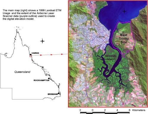
Introduction. The East Trinity case study describes the remediation of a severely degraded coastal acid sulfate soil site adjacent to the Cairns township in Queensland, Australia (Fig 1). The project involved extensive collaborative research into geochemistry, soil properties, groundwater and tidal behaviour, terrain modelling and flood modelling by a range of institutions. An innovative strategy known as lime-assisted tidal exchange (LATE) was used to reverse the acidification of the wetland, leading to improved water quality and health of coastal and estuarine ecosystems.

Acid sulfate soils are formed through a natural process that occurred when coastal lowlands were flooded in periods of high sea-level, leading to a slow build-up of metal sulfides such as pyrite. When these soils, normally protected by natural wetlands, are drained for farming or other development and exposed to oxygen, rapid oxidation of the pyrite occurred. This leads to a build-up of acidity in the soil as oxidation processes produce sulfuric acid, releasing toxic metals and noxious gases creating hostile conditions for plant growth. The acid also affects the availability of nutrients in the soil, creating another challenge for plant life. Rainfall events cause the acid, metals and nutrients to drain into waterways, impacting on aquatic ecosystems, infrastructure, fisheries and potentially, human health.

Figure 1. Aerial photo of he location of the East Trinity coastal and acid sulfate soil rehabilitation site (Source: Landsat 1999).

Figure 1. Aerial photo of he location of the East Trinity coastal and acid sulfate soil rehabilitation site (Source: Landsat 1999).

Prior condition and the degradation phase. East Trinity is a 940 ha coastal wetland situated between important estuarine habitats and a World Heritage listed wet tropical rainforest. Prior to clearing for farming, it was a mixture of paperbark woodland, tidal mangrove and salt marsh and had high ecological value for both marine and terrestrial faunal species. The area formed part of the traditional territory of the local Indigenous Mandingalbay Yidinji people.

The site was developed for sugar cane farming in the 1970s, with a bund-wall built to halt tidal inundation of the site. This drainage led to the oxidation of soil materials and a build-up of sulfuric acid in the sediments. A range of CSIRO and other reports showed that this affected 720 ha of the 940ha site. Between 1976 and 2004, it was estimated that at least 72,000 tonnes of sulfuric acid was released from the site, as well as soluble aluminium, iron, heavy metals and arsenic. Water bodies on site were routinely found to have a pH of 3.5 or lower. Aluminium levels were of particular concern, exceeding ANZECC guideline levels by as much as 6,000 times.

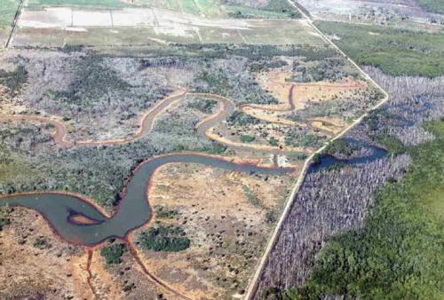
The discharge of acid and heavy metals led to death and dieback of vegetation (Figs 2 and 3) and had severe implications for aquatic life. These impacts were of particular concern due to the proximity of the site to the Great Barrier Reef Marine Park, with substantial evidence that acid sulfate soil runoff was discharging into reef receiving waters.

Figure 2a: Aerial view of Firewood Creek area from the 1980s showing extensive grasslands and Melaleuca leucadendra woodlands to the left of the bund wall roadway

Figure 2a: Aerial view of Firewood Creek area from the 1980s showing extensive grasslands and Melaleuca leucadendra woodlands to the left of the bund wall roadway.

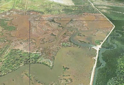
Figure 2b: Aerial view of Firewood Creek area in 2013 with extensive flooded areas, Melaleuca woodland die-back and mangrove development.

Figure 2b: Aerial view of Firewood Creek area in 2013 with extensive flooded areas, Melaleuca woodland die-back and mangrove development.

Fig 3. Iron accumulation in oxidised sediments at the East Trinity site.

Fig 3. Iron accumulation in oxidised sediments at the East Trinity site.

Remediation, rehabilitation and restoration phase. The land was purchased by the QLD government in the year 2000, with the ‘Acid Sulfate Soil Remediation Action Plan’ commencing shortly thereafter. This involved a range of engineering solutions to achieved the desired hydrology and apply the lime-assisted tidal exchange remediation strategy, at first on a trial basis. Positive results during the trial period led to the long-term adoption of lime assisted tidal exchange (LATE) at East Trinity.

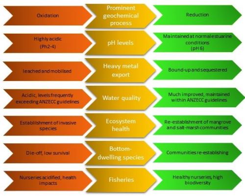
The LATE remediation strategy. Management strategies for acid sulfate soils are based on the principles of dilution, containment or neutralisation, with each bringing different benefits and challenges. Containment can lead to substantial acid build up and inhibit the movement of aquatic life, whilst the addition of agricultural lime can be costly. The LATE strategy (Fig. 4) was designed to support natural processes by reintroducing tidal flows, encouraging natural systems to restore the wetlands, hence greatly reducing the costs of lime and infrastructure, as well as hands-on management requirements. Flooding the soil stimulated reducing geochemical conditions whilst diluting the acidity. The bicarbonate in seawater provided a large source of alkalinity, whilst the organic matter present provided energy for microbial reactions to take place in the soil, thereby stimulating the in-situ production of alkalinity. Agricultural lime was added to the incoming tide to support the process, and also added to the out-going exit waters to prevent acid-flush into estuarine waters.

Fig 4. The image above shows some of the key parameters improved by the LATE bioremediation strategy.

Fig 4. The image above shows some of the key parameters improved by the LATE bioremediation strategy.

Results of the remediation project. The East Trinity site now has sediments at a spectrum of stages of remediation, with large areas fully remediated. Tidal inundation has ultimately led to a binding-up of heavy metals in the sediments and the neutralisation of acidity to a pH of 6.5, a typical pH for a subtropical estuarine environment. Following six years of gradually increasing tidal inundation, it was found that in-situ microbial and tidal exchange processes accounted for 99% of the change, whilst the addition of agricultural lime contributed less than 1%.

This greatly reduced the release of heavy metals to the estuarine environment and allowed for the re-establishment of mangrove and intertidal ecosystems (Fig. 2b).

Vegetation. Some ecological communities associated with the incursion of seawater and expansion of the tidal zones within the site have reduced while others have expanded. Mangrove communities have expanded and Acrostichum aureum (mangrove fern) fernlands have particularly increased, although some previous fernland transitioned to mangrove. Pasture areas have been largely replaced by Paperbark (Melaleuca leucadendra) shrublands and low woodlands and by the native grass Phragmites (Phragmites karka). The dieback of open forests of Paperbark impacted by the tidal areas continues, with some stands that were healthy in 2008 now in decline. Decline of low Clerodendrum inerme closed vinelands also continues in proximity to the tidal zone, though in other areas this community appears to be recovering.

Birds. A total of 136 species of birds have been observed at East Trinity since the rehabilitation began. Reports suggest that the expansion of mangrove and other higher elevation wetlands associated with the rehabilitation are likely to have benefited a number of bird species, including some internationally important shorebird species listed in agreements with China (CAMBA), Japan (JAMBA) and the Republic of Korea (ROKAMBA). Recently a new wader roosting site has emerged in mangroves on the northern boundary of the East Trinity area and it seems this may be significant in the regional context.

Future directions. The remediation of the East Trinity site has led to the area now having sufficiently high ecological function to be transferred back to Indigneous ownership and management.

The LATE remediation strategy’s regular tidal inundation will remain in place to ensure the acid sulfate soils remain protected from further oxidation; and monitoring and further research will continue into geochemical pathways to avoid degradation re-occurring.

Acknowledgements. The remediation of the East Trinity site and subsequent research has occurred due to the long-term efforts and collaborations between the Queensland Department of Science, Information Technology and Innovation (DSITI), CSIRO, the CRC for Contamination Assessment and Remediation of the Environment (CRC CARE) and Southern Cross University. Figures and data cited in this summary are derived from reports from these organisations available on request.

Contact. Prof Richard Bush, University of Newcastle (University Drive, Callaghan NSW 2308, Australia Tel: +61 (0)2 49215000; Email: richard.bush@newcastle.edu.au) .  Hanabeth Luke is an Associate Lecturer, Southern Cross University (Lismore, NSW 2480, Australia. Tel: +61 (0) 430092071; Email: Hanabeth.luke@scu.edu.au).

Stewartdale Nature Refuge koala habitat restoration in South Ripley, south east Queensland

Key Words: reconstruction, assisted regeneration, planning, koalas, conservation

Introduction: The Stewartdale Nature Refuge is located in South Ripley, south east Queensland on private land owned by the Sporting Shooters Association of Australia (SSAA). The 969 ha block contains live shooting ranges, large open areas dominated by pasture grasses, a substantial lagoon frequented by many bird species and extensive natural areas. The area being restored is 211 ha of dry sclerophyll vegetation, containing a number of Regional Ecosystems (REs) being restored through large scale planting (reconstruction) and assisted regeneration approaches. Its conservation value is heightened by the fact that it connects to the Karawatha Flinders Corridor, the largest remaining stretch of open eucalypt forest in south-east Queensland.

Condition ranges from large degraded areas (i.e. pasture) to native vegetation that contains both regrowth and remnant dry sclerophyll. All areas were impacted by varying levels of weed infestation due to previous clearing and ongoing disturbance from cattle grazing. Natural disturbances such as regular fire and periodic floods have also contributed to disturbance at the site. More than 30 weed species impact the project area at varying levels and the species and impacts vary with the condition of the land. Open areas were dominated by pasture grass such as Setaria (Setaria sphacelata) and Rhodes grass (Chloris gayana) in addition to fast growing annuals, although infestations of Leucaena (Leucaena leucocephala), Prickly Pear (Opuntia stricta) and large clumping Bamboo (Bambusa sp.) also required significant control efforts. In more forested areas (and underneath isolated remnant trees) weed species included Lantana (Lantana camara), Creeping Lantana (Lantana montevidensis), Corky Passionfruit (Passiflora suberosa), Easter Cassia (Senna pendula var. glabrata), Siratro (Macroptilium atropurpureum) and exotic grasses, annuals and groundcovers.

The aim of the project is to restore, native plant communities present within the Stewartdale project site to support local koala populations. Our goals are to:

  • Repair native vegetation including the structure, integrity and diversity to support koala populations
  • Strengthen the resilience and regenerative capacity of native vegetation
  • Restore and expand native regrowth vegetation by controlling weeds
  • Maintain the project site so weeds do not negatively impact the development and recovery of native vegetation
  • Protect drainage lines, gullies and slopes from erosion
  • Protect and enhance the water quality of Bundamba Lagoon
  • Construct fauna friendly fencing across the site with the aim of protecting planted trees from herbivory
  • Reduce the risk of fire moving through the site and impacting restoration works by conducting strategic slashing activities to reduce fuel loads.

Planning. A restoration plan was developed after detailed site assessments and negotiations with the landholder, land manager and state government were finalised integrating Nature Refuge conditions and current land use and future management requirements. The site was divided into zones and sub-zones to assist directing works including applying a range of restoration approaches – i.e. assisted regeneration and reconstruction (‘revegetation’) and several planting models and species mosaics to different parts of the site. Detailed maps were produced for each zone and included information such as the location of all tracks, fences, assisted regeneration zones, wildlife corridors, planting areas according to each RE and numbers of species and plants to be installed per zone. The plan also included detailed information on restoration approaches; weed control at all stages of the project; seed collection and propagation; site preparation including the specifications and location of all fencing, tracks, rip lines and areas of concern (i.e. identified hazards across the site); how to carry out all works in each zone; site maintenance requirements for 5-7 years; and monitoring requirements.

PP2b after site preparation.JPG

Fig 2. Preparation for planting  at Stewartdale Nature Refuge.

PP2b after planting Mar 2016

Fig 2. After planting to support local Koala population, Mar 2016.

Works to date. Site preparation commenced with the collection of seed from on and around the wider property and surrounds ensuring that all species to be planted were collected from a minimum of 10 widely spaced parent trees. Primary weed control started with the control of weeds in the 65 ha of assisted regeneration zones and the control of other woody weeds across reconstruction areas in preparation for slashing and other activities. More than 18 km of fauna friendly fencing (i.e. no barbed wire) was installed to protect planted stock from browsing by large herds of macropods and cows. Two large corridors were retained for fauna to reach Bundamba lagoon from different parts of the regional corridor as it is an important resource for many local and migratory fauna. Slashing across open areas was commenced and followed by the installation of rip lines to alleviate soil compaction and assist efficient planting activities. Weeds and pasture grasses were then sprayed out along all rip lines. 114 000 koala food and shelter trees were planted according to the RE for each section and according to the local conditions (i.e. whether it was low lying, on a ridge or near infrastructure). Some additional frost resistant and local Acacia species were also added to particularly frost prone areas to assist the development of a canopy and the protection of developing vegetation.

The 114 000 tubestock were installed over a 7 week period with the last stems being planted in April 2015. All trees were fertilised and watered at the time of planting and where possible, slashed grass spread across the rip lines to assist retaining moisture and slowing weed regrowth. (Follow-up watering was applied to all planted stock between September and October 2015) Nearly 2000 (1 m high) tree mesh guards were installed to protect planted stock in fauna corridors.

Series shot 1.1

Careful spot spraying to reduce weed while protecting natives

Series Shot 1.2

Growth of saplings is improved without competition.

Results to date. As of March 2016, weeds have been significantly reduced across the 65 ha of assisted regeneration areas. Unfortunately a wildfire fire went through approx. a third of the project area after primary and follow up weed control works had been completed. Fortunately the event was prior to planting though the fire did reduce the number of trees regenerating in assisted regeneration patches as many were too young to withstand the fire. New germinations are however occurring and the level of native grasses, groundcovers and other native species have increased due to ongoing weed control efforts.

Despite heavy frosts in winter 2015, a flood event in May 2015 (150 mm of rain fell in 1.5 hours) and now an extended dry period, the planting is developing well with the average height of trees at over a metre tall and mortality under 5%. Weed control is continuing across the project site with efforts currently concentrating on the control of many annual weeds such as Cobbler’s Peg (Bidens pilosa), Balloon Cotton (Gomphocarpus physocarpus) and Stinking Roger (Tagetes minuta) and many exotic grasses such as Setaria (Setaria sphacelata) and Rhodes grass (Chloris gayana) to reduce competition to planted stock. Assisted regeneration areas are being joined up to planting zones wherever possible to further assist the development of the site.

It should also be noted that Birds Australia have recorded 69 bird species on site.

Ongoing works: Regular maintenance continues on the site with the control of weeds particularly along rip lines where weed germination and growth is rapid. Slashing is also regularly done between the rip lines and along tracks and fence lines to assist access around the site and the management of fuel loads and therefore wildfire across the site. It is expected that the time it takes to complete each maintenance rotation will begin to reduce as plants become more established and start to develop a canopy.

Weed control will also continue in all assisted regeneration zones and is also expected to reduce with the development of native vegetation structure and diversity together with the reduction of the weed seed bank. Ongoing slashing, fence maintenance and monitoring will continue for another 3-5 years though the exact time period will be determined by the State government.

Monitoring including soil moisture readings, transects to assist determining survival rates across the site and photographic monitoring is regular and further supports 6 monthly reporting requirements.

Stakeholders and funding bodies: Department of Environment, Heritage and Protection, Queensland State Government; Sporting Shooters Association of Australia (SSAA). Photos: Ecosure.

Contact Information: Jen Ford (Principal Restoration Ecologist, Ecosure TEl: +61 (0)7  3606 1038.


Restoration at Numinbah Conservation Area, City of the Gold Coast, Queensland

Key Words: assisted regeneration, restoration planning, conservation

Introduction: Numinbah Conservation Area, located in the hinterland of the Gold Coast in south-east Queensland, is one of many natural areas managed by City of Gold Coast’s Natural Areas Management Unit (NAMU). The 598 ha property contains 12 Regional Ecosystems (REs) ranging from sub-tropical and dry rainforest to dry and wet sclerophyll types; and include riparian zones, steep areas, gullies and rocky outcrops. Its conservation value is heightened by the fact that it connects to other reserves including the World Heritage areas of Springbrook.

Condition ranges from large degraded areas (i.e. pasture) to native vegetation that contains both regrowth and remnant areas. All areas were impacted by weeds due to previous disturbance from logging and subsequent cattle grazing. More than 35 weed species impact the site at varying levels with the most notable species across the site being Lantana (Lantana camara). Edges are impacted by exotic vines such as Glycine (Neonotonia wightii), the understorey by many herbaceous weeds such as Mistflower (Ageratina riparia) and rainforest zones by persistent weeds such as Coral Berry (Rivina humilis) and Passion Vines (Passiflora spp.) to name a few. Approximately 60 hectares of open area are dominated by pasture grasses and other weeds.

The aim of the project is to restore, to the extent possible, the structure, function, dynamics and integrity of the pre-existing vegetation and the sustaining habitat that is provided. Our goals are to:

  • Improve the health of vegetation and habitat types across the site
  • Improve connectivity for flora and fauna
  • Reduce fuel levels in fire prone ecosystems and the risk of hot fires sweeping through the site and wider landscape
  • Increase the resilience of the site
  • Improve water quality
  • Increase the health, populations and distribution of threatened species – flora and fauna
  • Reduce the need for weed control maintenance over time i.e. to a level of minimal maintenance
  • Provide nature based recreational opportunities and environmental education along this section of the Gold Coast Hinterland Great Walk

Planning. An ecological restoration plan was developed after detailed site assessments and the site was divided into precincts, zones and sub-zones to assist directing works. Information in the plan included species lists, weed control information, maps and detail on how to restore each area and progressively link zones. A detailed fire management plan was also developed for the site that took into account wildfire mitigation, restoration zones, the location of threatened species, site objectives, REs including their recommended fire regimes, and the capacity of areas to regenerate.

Works to date. Works over the last 9 years have covered more than 190 ha. The main approach to restoration has been via assisted regeneration consisting mainly of large scale weed control and the fencing of areas to reduce the impact of cattle. Further works have involved planting a section of creek to assist stability and connectivity across a section of the site; and the propagation and translocation of four threatened flora species (details not disclosed for security reasons).

Where low intensity fuel reduction burns were conducted in dry sclerophyll vegetation, timely follow up weed control was applied to ensure re-shooting Lantana, Molasses Grass (Melinis minutiflora) and other weeds did not fill gaps and to support the colonisation and growth of native vegetation. In remnant and regrowth vegetation, systematic weed control using a range of techniques has been applied. E.g. large areas of Lantana were controlled using three techniques: cut, scrape and paint where it was in close proximity to native plants; over-spraying after isolating infestations; and, spot-spraying when it germinated or was re-shooting. Weed species were continually suppressed to ensure native species germinated and grew to a point where most gaps have been filled with native vegetation. As each area developed and maintenance reduced, efforts were put into continually expanding the work fronts.

A propagation and translocation project was also implemented in partnership with Seqwater. More than 1150 individuals (four species) have been propagated, planted into their particular niche and have been monitored and reported on annually. This will continue until all species are considered to be self-sustaining i.e. flowering, fruiting and reproducing.

(a)NCA8n_20080502

(b)NCA8n_20080827

(c) NCA8n_20090716

(d)NCA8n_20100625

(e)NCA8n_20110630

(f)NCA8n_20151130

Figure 1, (a-f) represents an annual sequence of recovery after control of Lantana and subsequent weed at one photopoint from 2008 to 2011, with the last photo taken in 2015. The results reflect accurate and timely weed control to support the recovery of native vegetation. (Photos: City of Gold Coast)

Results to date. As of July 2015, weeds have been significantly reduced across the 190 ha treated area to a point where maintenance is being applied, with some areas requiring little to no maintenance. In a number of areas this reduction of weed has also significantly reduced fuel levels.

Increased abundance and diversity of native vegetation has occurred across a range of ecosystem and habitat types within the reserve. Open areas once dominated by dense Lantana have taken approx. 3 years to naturally regenerate with a range of pioneer, early secondary and later stage rainforest species (Figs 1-3). Many of those areas now include continuing recovery of later stage species and contain a large diversity of seedlings, groundcovers and ferns. More diverse communities have recovered with a large range of species (depending on the ecosystem / ecotone) and support a diversity of fauna species. Works in four of the larger precincts have now joined up and weed control works are continuing to expand all regenerating areas.

More than 7000 plants installed along the open riparian stretch are establishing with native species regenerating amongst the planting. After approx. 7 years the average height of the planted canopy is approx. 5-7m tall.

Ongoing works: All current work zones are being continuously extended ensuring progress made is maintained. The open area (e.g. paddock) is being reduced over time as vegetation is encouraged to expand (i.e. by continuing to control weeds to past the drip lines of all native vegetation). Fences that currently contain cattle (i.e. to assist managing open areas for access, fire management and to ensure funds are spent in more resilient areas) are being moved to continue to reduce the size of highly degraded areas. Fire management, large scale weed control and the monitoring and evaluation of threatened species, together with fauna surveys, is continuing.

Stakeholders and funding bodies: Natural Areas Management Unit (NAMU), City of Gold Coast and Seqwater. Contact Information Paul Cockbain, Team Leader Restorations +61 7 5581 1510


Donaghy’s Corridor – Restoring tropical forest connectivity

Key words: tropical forest restoration, habitat connectivity, small mammal recolonisation, ecological processes, community partnerships.

Introduction. Closed forest species are considered especially susceptible to the effects of forest fragmentation and habitat isolation. The Wet Tropics of north Queensland contains many forest fragments between 1ha and 500ha, mostly surrounded by dairy and beef pastures, and crops such as maize, sugar cane and bananas. Larger blocks are often internally fragmented by roads and powerlines. The Lake Barrine section of Crater Lakes National Park is a 498ha fragment that is 1.2km distant from the 80,000ha Wooroonooran N.P, and ecologically isolated since the 1940s with detectable effects on genetic diversity of rainforest mammals.

In 1995 the Qld Parks and Wildlife Service, along with landholders and the local ecological restoration group TREAT Inc., began riparian forest restoration along Toohey Creek to re-connect the Barrine fragment to Wooroonooran and to document colonisation by small mammals and native plants typically associated with rain forest environments (Fig 1).

AERIAL VIEW

Fig 1. Donahy’s Corridor, Atherton Tablelands, linking Crater Lakes NP and Wooroonooran NP, Qld (Photo TREAT).

Connectivity Works. Prior to works commencement, small mammal communities (e.g. Rattus spp. and Melomys spp.) along and adjacent to Toohey Creek were sampled, along with a full vegetation survey, to determine base-line community composition and structure. Permanent stock exclusion fencing was erected and off-stream stock watering points established.

A 100m wide corridor of vegetation was established over a four year period using local provenances of 104 native species comprising around 25% pioneer species, 10% Ficus spp., and the remainder from selected primary and secondary species. In total, 20,000 trees, shrubs and vines were planted along the creek, and a three-row shelterbelt was planted adjacent to the corridor to reduce edge effects. Species were selected on a trait basis, including suitability as food plants for targeted local fauna e.g. Cassowary (Casuarius casuarius johnsonii).

Ecological furniture (e.g., rocks, logs) was placed prior to planting. On completion, the 16ha Donaghy’s Corridor Nature Refuge was declared over the area, recognising the Donaghy family’s significant land donation and the corridor’s protection by legislation. A three year monitoring program, conducted quarterly, commenced on completion of planting.

TREAT2012Donaghy'sCorridor22

Fig. 2. Developing rainforest in Donahys Corridor (Photo Campbell Clarke)

Monitoring. Flora monitoring was conducted along transects bisecting the four annual plantings (1995/96/97/98), and small mammal colonisation in 11, 20m x 20m plots located in the plantings, adjacent open paddocks, and in forests at either end. Small mammal sampling included mark-recapture and DNA studies, to determine colonisation and movement patterns and genetic effects.

Results. Three years after establishment, over 4000 native plants were recorded – representing 119 species from 48 families. This included 35 species naturally dispersed from the adjacent forest (Figs 2 and 3). Small mammal sampling showed 16 long-distance movements by Rattus species and the appearance of an FI hybrid Bush Rat (Rattus fuscipes) in the central section of the corridor in the third year of the study. The rainforest rodent Fawn-footed Melomys (Melomys cervinipes) had established territories in the second year of the study. A study of wood-boring beetles (Coleoptera)in ecological furniture showed 18 morpho-species in a three year period. Many other orders/families were also recorded.

Water quality in Toohey Creek was not studied but has continued to increase since the replacement exotic grasses with woody vegetation, and the exclusion of cattle from accessing the stream. There is increased shade available for stock and less pressure on the limited number of existing paddock shade trees.

TREAT2012Donaghy'sCorridor18

 Fig. 3. Indicators of rainforest structure (species and layering) and functions (habitat providion, nutrient cycling, recruitment) are now highly evident. (Photo Campbell Clarke).

What we learned.

  • Plant colonisation was rapid, dominated by fleshy-fruited species (10-30mm diameter), of which a proportion are long-lived climax species
  • Plant colonisation was initially highest in the interior, close to the creek margin, but has become more even over time
  • Vegetation structural complexity and life form diversity have continued to increase since establishment
  • Small mammal communities changed in response to habitat structure, grassland species dominate until weeds are shaded out when they are replaced by closed forest species
  • Many long distance mammal movements occurred that were only detected by genetic analysis
  • Monitoring showed small mammals used the new habitat to traverse from end to end until resources were worth defending: at that time long distance movements declined and re-capture of residents increased
  • Partnerships between government, research bodies, community groups, and landholders are essential if practical solutions to fragmentation are to be developed and applied

Acknowledgements: Trees for the Evelyn and Atherton Tableland acknowledges and appreciates the support of all the volunteers involved in this project, staff from the Qld Parks and Wildlife Service-Restoration Services, , James Cook University, University of Qld, Griffith University and UCLA Berkely. In particular we would like to acknowledge the Donaghy family.

Contact: TREAT Inc. PO Box 1119, Atherton. 4883 QLD Australia. http://www.treat.net.au/

SEE ALSO:

Global Restoration Network Top 25 report: http://www.treat.net.au/projects/index.html#donaghy

Watch the video on RegenTV – presented by Nigel Tucker