Category Archives: Education & communication

Lake Bolac Eel Festival and Environmental Forum – 25-26 March 2022

Figure 1. An Environmental Forum is a held at each Lake Bolac Eel Festival to bring to the festival-goers reliable information about the ecology of the region and its potential for improved management. (Photo Tein McDonald)

Introduction. Cultural events are increasingly recognised as critical to cultural change and community awareness building. One outstanding example is the Lake Bolac Eel Festival (Kuyang Lapakira – Plenty Eels), a biennial festival held at Lake Bolac in the western basalt plains of Victoria to celebrate environmental repair and Aboriginal cultural revival (Figs 1-5).

The timing of the festival reflects the season when Kuyang (Shortfinned Eel, Anguilla australis) begins its migration to the sea to spawn and when the First Nations Communities from surrounding areas gathered to harvest the species, trade and hold ceremonies. As such the festival is a significant gathering place for people who care for the environment and respect Aboriginal cultural heritage, promoting the restoration of Lake Bolac and surrounding waterways.

Figure 2. The 2022 Eel Festival’s Welcome to Country was conducted by Traditional Owner Brett Clarke with the assistance of local Indigenous community members. The Festival is a gathering of new generations of people affirming the traditions of past generations who cared for the lands and waters of the Lake Bolac area. (Photo Ayesha Burdett)

Figure 3. The festival is very small but is attended by many locals and those serious about ecological and cultural restoration. In 2022, workshops on topics including tanning Eel leather, Indigenous tools and song-making, and childrens’ craft activities were interspersed among music and dance events. (Photo Tein McDonald)

An Environmental Forum is a regular part of each festival program. At this year’s forum, chaired by freshwater wetland ecologist Michelle Casanova, six presenters including Traditional Owners, Glenelg Hopkins Catchment Management Authority representatives, the local Landcare group, local landholders and researchers provided rich information about the significance of the site, the eel and its habitat,  management strategies, and roles of stakeholders.

The Forum commenced with a moving Welcome dance and a smoking ceremony led by Traditional Owner Brett Clarke. The first speakers were Tim Hill and Jileena Cole, Chair and Facilitator respectively from the Beyond Bolac Catchment Action Group, who described the context of the efforts to protect and repair eel habitats in a production landscape. Brett Clarke then spoke movingly on the role of First Nations people caring for Country and culture. The third speaker was Greg Kerr, Senior Ecologist with Nature Glenelg Trust, who focused on exploring the idea of ‘home’ for animals in Lake Bolac, while the fourth speaker, John Sherwood from Deakin University, intrigued the audience with his presentation on recent evidence of the Moyjil archaeological site at Warrnambool Victoria that suggests far earlier habitation of Victoria by Aboriginal people than is conventionally understood.

Damein Bell – member of the Gundtijmara community, CEO of Gunditj Mirring Traditional Owners Aboriginal Corporation and currently a Board Member with the Glenelg Hopkins Catchment Management Authority – spoke engagingly on the long effort to have the Budj Bim Cultural Landscape recognised on the UNESCO World Heritage List in July 2019. This account reinforced the importance of patient and persistent action to effect social change.

Perhaps the most intriguing talk was the presentation by the sixth speaker, Wayne Koster from the Arthur Rylah Institute (DELWP) who regaled us with what is currently known about the migration of the Short-finned Eel. This species is native to the lakes, dams and coastal rivers of south-eastern Australia, New Zealand, and much of the South Pacific, but very little has been historically known about its reproduction or where this takes place. Preliminary results were presented of Waynes’s recent work satellite tracking oceanic migrations of the Short-finned Eel, with migration track to the Coral Sea between New Caledonia and Australia.

Figure 4. The large tent provides the setting for both the Environmental Forum and the later musical events. (Photo Tein McDonald)

Figure 5. The day’s activities culminated in a Twilight ceremony featuring Aboriginal dancers, followed by a concert headlined by local musician and one of the Festival founders, Neil Murray. ( Photo Una Allender).

Stakeholders: The event is managed by the Lake Bolac Eel Festival Committee. Funders include: Grampians Pyrenees Primary Care Partnership, Victorian Regional Arts Fund Community Grants Round 2 2019, Ararat Rural City Council; Regional Arts Victoria, Beyond Bolac Catchment Action Groups, Stronger Communities Programme Round 7 – Wannon, Visit Victoria – Regional Community Events Fund, Glenelg Hopkins CMA, Willaura Lake Bolac Community Bank and NBN Local.

Contacts: Una Allender <uallender@bigpond.com> or Ayesha Burdett <ayesha.burdett@gmail.com> Lake Bolac Eel Festival Committee.  Media contact: Sally Gibson <sgibsonaustralia@gmail.com>

Koala conservation and the role of private land – UPDATE of EMR feature

Daniel Lunney, Alison Matthews, Chris Moon and John Turbill

[Update of EMR feature – Lunney, Daniel, Alison Matthews, Chris Moon and John Turbill (2002) Achieving fauna conservation on private land: Reflections on a 10-year project. Ecological Management & Restoration, 3:2, 90-96. https://onlinelibrary.wiley.com/doi/10.1046/j.1442-8903.2002.00100.x]

Key words: SEPP 44, Coffs Harbour, logging, urban development, New South Wales, ecological history, koala plan of management.

Introduction. Our 2002 paper in EMR focused on the local government area (LGA) of Coffs Harbour and reflected on our approach to meeting the challenge of finding a means of protecting populations of  Koala (Phascolarctos cinereus) on private land before habitat removal brought about their local extinction. This was prompted by our 1986–1987 state-wide koala survey that found that koala  populations had declined across New South Wales, largely as a result of habitat loss. The remaining koala stronghold, we identified at the time, was on the north coast, in areas such as in the rapidly expanding city of Coffs Harbour. Koalas in Coffs Harbour were found mostly on privately-owned land outside National Parks and Nature Reserves and State Forests.

It took 10 years (1990-2000) of struggle with politics, bureaucracy and vested interests to achieve a plan of management across one local government area (Coffs Harbour) to save koala habitat from the relentless clearing of private land. The reward for our efforts was a Comprehensive Koala Plan of Management (CKPoM), prepared under State Environmental Planning Policy 44 – koala habitat protection (SEPP 44), and adopted by Coffs Harbour City Council in 1999. SEPPs apply only to land over which local government has authority, not Crown Land, i.e. National Parks, Nature Reserves and State Forests. The Plan identified and ranked Koala habitat and set out criteria for minimizing local threats. It is a statutory instrument, gazetted in 2000 along with council’s Local Environmental Plan (LEP), which controls land-use planning. It was the first CKPoM in NSW and a demonstrated formula for undertaking such plans. Now in 2019, 20 years after the plan was formally adopted by Coffs Harbour City Council, and in the NSW parliament in 2000 as part of the Coffs Harbour LEP, the plan is still in place. We count that as a success. While revisions to both the SEPP and the Coffs Harbour CKPoM are in the wind, the 1999 plan still stands, as of October 2019.

Further, after five years of operation, Coffs Harbour council commissioned a strategic review of its CKPoM from the consultants, EcoLogical, which found that there was a 1.1% reduction in the area of primary koala habitat. In our view, such a small change over 5 years is an indication of the CKPoM’s impact in halting habitat loss on private land.

Figure 1. Historian, and co-worker, Antares Wells examining a document with items from the history of the Bellinger, the LGA immediately to the south of Coffs Harbour, as part of our study of the ecological history of the region. (Photo Dan Lunney 2013/)

Further studies. To add context to our work in Coffs Harbour, we undertook a range of further studies. These included an historical study, looking at the koala records from European settlement to 2000 through an ecological lens (Fig 1). The first wave of European settlers arrived in the early 1880s, and much of the initial development arose from logging. Collectively, the evidence identifies that the koala population of Coffs Harbour was widespread but never abundant, and that habitat loss has been relentless since European settlement. The transformation of a rural-forest mosaic to an urban landscape over the past four decades is the most recent stage in the incremental loss of habitat.

Also, in 2011, we undertook a repeat study of the koala population within Coffs Harbour LGA from our initial survey in 1990. Analyses showed that the koala population has endured between 1990 and 2011 and showed no evidence of a precipitous decline during this period. Rather, the population change was best characterised as stable to slowly declining.

The extensive koala datasets gathered since 1990 on the Coffs Harbour koala population are attractive for researchers and managers. They provide the basis for revisiting the LGA to look for change (Fig 2.) . Work in June 2019, for example, included the following: Department of Planning, Industry and Environment at Coffs Harbour is finalising a review of the Coffs Harbour LGA koala habitat study from funding by council; surveys completed in April 2019 revisited 68 of the original 119 sites we had selected in 1996, and 89 of those sites we had re-surveyed in 2011, and the total number of sites visited in the current survey was 176 in a report to Coffs Harbour council in September 2019.

Figure 2. Koala team standing in koala habitat near Bonville, Coffs Harbour LGA. From left to right, John Turbill, Martin Smith, Indrie Sonawane, Chris Moon and Martin Predavec. (Photo Dan Lunney 2013).

Mixed results. Rereading our original paper is unsettling. There is an enduring sense that the entire exercise, while locally worthwhile, has not translated into wider successes with respect to policy and implementation. Although our assessment of the success of the Coffs Harbour CKPoM is upbeat, the uptake of the concept by other councils has been modest. Some have opted for a koala plan of management, but not within the SEPP 44 framework, and others have contracted the preparation of the plans, but only using field survey data for koalas, not the citizen science component.

Among our reflections on our work is that the languages of planning, conservation and ecology need to be calibrated. Confusion has occurred because SEPP 44 refers to potential and core koala habitat when a Development Application (DA) is being assessed, but in the CKPoM in 1999 we used the terms primary, secondary and tertiary koala habitat. Adoption by local government of a CKPoM replaces the requirement to assess each individual DA for core habitat, because the CKPoM has mapped and ranked this habitat. In fact, the ease of seeing koala habitat on a map, ranked so that you know what development is possible, or not, within the particular ranking, expedites the DA process for all parties. This was a major selling point for Coffs Harbour council, along with our economic study which demonstrated that the value of having a koala population in the LGA exceeded the cost of implementing such a plan (Fig 3). While habitat ranking is appropriate for a CKPoM – a land-use planning and management instrument – one interpretation, a misguided one in our view, has been that primary habitat equals core habitat, and deems primary habitat in a CKPoM to be the only level of habitat to conserve. Such a view not only disregards the value of rankings for the purpose of planning, but also ignores the multiple ways that koalas need to use the landscape. We note that more recent plans have divided secondary habitat into secondary A and secondary B, but that does not change the principle of ranking. We also note that a recent choice is to use ‘core’ habitat in a CKPoM, although with a different approach to defining ‘core’, but this has yet to be consolidated in the proposed revised SEPP 44. On reflection, ‘core’ has become a problematic word because it implies that anything other than core can be ignored.

There have been considerable recent efforts to catch up on survey methods for koalas in State Forests. However, pressure remains on State Forests concerning their koala populations, such as the campaign by the National Parks Association of NSW for ‘The Great Koala National Park’ to add 175,000 ha of State Forests to existing protected areas to form a 315,000 ha reserve in the Coffs Harbour hinterland. National Parks and Nature Reserves are a central element in our efforts to conserve our fauna, but a transfer of State Forests to National Parks does not come to grips with the issue of the loss of habitat on private lands, including in situ habitat and linkages across the landscape.

SEPP 44 was promulgated in 1995, and while we recognise that it needs to be updated, our point remains that it has demonstrated potential to conserve koala habitat on private land, with an explicit role, indeed a key role, for local government. Strategies to conserve and restore koala habitat on private land—particularly on the more fertile lands, which are also the prime lands for farms and towns—will continue to be central to conserving the koala populations in NSW.

Figure 3. Economist Clive Hamilton explaining the economic advantages of conserving koalas in Coffs Harbour LGA. This presentation was given in Coffs Harbour at a national meeting for Ecological Economics. (Photo Dan Lunney 1996.)

Lessons learned and future directions. In 2019, our reflections on our 10-year study (1990-2000) allow us to conclude that identifying koala habitat on private land is possible, that plans to conserve it are acceptable, that the economic aspect is an important factor in the negotiations, and that local government has a role to play in this process. Since 2002 we have expanded our research horizon, crossing other disciplinary boundaries to encompass ecological history, using more sophisticated approaches to citizen science, stretching our geographical horizon to the north-west of NSW, incorporating the pervasive impact of climate change, and teasing out the contribution of koala care and rehabilitation and the value of detailed population studies such as by radio-tracking. We also conclude that local studies, especially repeated studies, e.g. at the LGA or Local Land Services (LLS) scale, are crucial, along with broad scale, periodic, state-wide surveys to keep track of the considerable individual differences across the geographic range of the koala.

Contact.  Daniel Lunney, Department of Planning, Industry and Environment NSW (PO Box 1967, Hurstville NSW 2220 and the University of Sydney, NSW 2006. dan.lunney@environment.nsw.gov.au

The arts and restoration – a fertile partnership

David J. Curtis

[Update of EMR feature: Curtis, David J (2009) Creating inspiration: The role of the arts in creating empathy for ecological restoration. Ecological Management & Restoration, 10:3, 174-184. https://doi.org/10.1046/j.1442-8903.2003.00152.x]

Key words: creativity, ecological restoration, capacity building environmental attitudes, environmental behaviour


Figure 1. The Plague Demon — a puppet made from 3000 plastic shopping bags by a team of 30 people. It rose to a height of 6 metres and represented the equivalent of 3 hours of plastic bag consumption for the city of Armidale. It was used in the Armidale Autumn Festival parade in March 2004 (pictured) and the production of Plague and the Moonflower in the main arena of the Woodford Folk Festival in 2003 to an estimated audience of 10,000 people. (Photo Garry Slocombe)

Introduction: In my original article for EMR in 2003, I posed the question: Are the arts a valuable partner with ecological restoration? The article was written early in my research into the role of the visual and performing arts in shaping environmental behaviours. I answered this research question through key informant interviews, analyses of several case studies and participant observations, and concluded that there was indeed substantial potential for the arts to create inspiration and empathy for ecological restoration. The research continued until 2007 with the completion of my PhD thesis but the outputs of that research continue to the present day, with numerous journal papers and book chapters (see bibliography). It has also led to the formation of the non-government organisation Ecoarts Australis and the coordination of three international conferences around these themes: 2013, 2016, and 2019, all of which  demonstrate the high potential for fertile partnerships between the arts and ecological restoration.

Further works undertaken: The main case study in the 2003 article for EMR was the ecological oratorio Plague and the Moonflower that was staged in Armidale NSW in 2002 by the Armidale community. The Armidale community went on to restage the work and take 300 performers to the Woodford Folk Festival in 2003 to perform it in the main arena to about 10,000 people (Fig. 1). A further seven case studies were developed including: an examination of attitudes and practices of about 100 arts, farming and natural resource management practitioners; the Nova-anglica: the web of our endeavours event staged in Armidale in 1998 to an audience of approx 5,000 people (Tables 1 & 2); the Gunnedah Two Rivers Festival in 2002-04 and the Bungawalbin Wetlands Festival, both of which incorporated visual and performing arts (Tables 1 and 2); a play-building study with secondary aged school children in 2002 examining the greenhouse effect; participant observations of my own work from 1990-2000 in which I incorporated the arts into natural resource management extension (https://www.publish.csiro.au/book/6713/) and the Ecological Society of Australia conference in 2003 in which we incorporated an ambitious performing and visual arts program (Fig. 2).

Figure 2. As part of the arts program of the Ecological Society of Australia Conference, Armidale 2003, this commissioned image, In the Balance, summarized the themes of the conference. (Image Anna Curtis. Lino reduction print on paper, 30 x 30 cm, 2003)

Findings from the subsequent research. Papers listed in the bibliography referred to above show that the arts have an important role in:

  • raising awareness and communicating environmental information (Table 1) through environmental education and extension;
  • changing and challenging environmental beliefs (Table 1);
  • communicating scientific information (Fig. 2);
  • mobilising rural communities to achieve environmental sustainability and community capacity building for Landcare and environmental action (Table 1; Fig. 1);
  • creating empathy for the natural environment and ecological restoration (Fig. 3);
  • transforming our highly energy-intensive consumer society to one that is ecologically sustainable through community development and embedding the arts in ecologically sustainable development .

In addition, particular art events could encourage people to want to adopt pro-environmental behaviours (Table 2) as well as:

  • encourage people to reflect about their impact on the environment;
  • make them feel strongly towards the natural environment;
  • expose them to ideas they hadn’t thought about much before;
  • affirm their beliefs about people’s relationship with the environment;
  • help people learn about environmental issues; or
  • provide a vehicle to express feelings about the environment (Table 1).

Figure 3. Ephemeral clay sculptures with impregnated native seeds, Artist Andrew Parker. These sculptures were part of an ephemeral art project organised by Ecoarts Australis as part of the Black Gully Music Festival in Armidale in 2016. The sculptures were integrated into the ecological restoration project along Black Gully. As they decayed, the seeds were released and germinated, adding to the revegetation of the creek. (Photo David Curtis)

Implications for arts : restoration relationships:  It is clear that the work of individual artists can influence the behaviour of citizens through ‘internally derived’ interventions, which impinge on a person’s values, beliefs, knowledge, attitudes, self-identity and habits, and through these, on social norms (Fig. 4). However, desire by individuals to adopt pro-environmental behaviour can be hampered by situational or infrastructure constraints. The arts can also have a role in reducing some of these constraints, through ‘externalist interventions’ where the arts are embedded into ecologically sustainable development. This might be where community and public art are incorporated into urban planning as a means of making active transport modes more attractive, or where the arts provide alternative forms of consumption which are lower in embodied energy and higher in embodied labour. The degree to which a person responds to the arts will depend on personal characteristics (e.g. gender, class, etc.), situation, institutional factors, as well as the type of art. The accumulated result of individual behaviours leads to macro-level impacts on the environment. A knowledge of these impacts in turn influences individual artists, and affects their practice.

Figure 4. Model of how the arts affect environmental behaviour.

I found that the arts can foster pro-environmental behaviour through one of three ‘pathways’ (Fig. 5). The first pathway is where the visual and performing arts are used to synthesise complex ideas and to communicate them to non-specialist audiences in an engaging form. A second pathway is where the arts and particular artists connect their audience to the natural environment through thoughtful or evocative representations of the environment or by being in the natural environment itself. The third pathway is where the arts are embedded in ecologically sustainable development, through the combined effects of community development, economic development, and changes in the patterns of consumption.

Figure 5. Three pathways in which the arts can be used to help achieve ecological sustainability.

The three Ecoarts Australis conferences were a culmination of the work that I did following the 2003 EMR article. These three pathways provided the structure for each conference, and enabled the innumerable Australian and international examples that were presented to be organised into a coherent conceptual framework. It was evident through these conferences that there has been a shift in projects that link the arts to environmental sustainability. In the first two conferences a majority of the papers provided examples of where the arts fell into the first or second pathways. In the most recent conference there were more examples where the arts were integrated into ecologically sustainable development in some way, for example in transport or manufacturing. Also there seemed to be a shift towards multi-artist projects.

Stakeholders and Funding bodies:  Funded by Land and Water Australia and Rural Industries Research and Development Corporation.

Contact information: Dr David Curtis, Honorary Senior Fellow, School of Geography and Sustainable Communities, Faculty of Social Science, University of Wollongong NSW 2522 Australia.

Table 1: Comparison of case studies as to how the event affected respondents. Respondents were scored: 1 = strongly disagree, 2 = disagree, 3 = neither agree nor disagree, 4 = agree, 5 = strongly agree.


Responses to survey

Those who agreed (score 4-5) as a percentage of all respondents
Plague and the Moonflower

(n = 169)

Nova-anglica (n = 9) Gunnedah (Twin Rivers)

(n = 11)**

Gunnedah (Common Ground)

(n = 46)

The event moved me emotionally 73 44 18 45.6
The event made me reflect on humanity’s relationship with the natural environment 74

(n = 168)

67 36 61.7

(n = 47)

The event made me feel strongly towards the natural environment 60

(n = 168)

78 18 58.7
The event made me feel an appreciation and pride in community 81


89 91 73.9
The event exposed me to ideas that I may not have thought much about before 31

(n = 167)

89 36 34.8
The event affirmed my beliefs about humanity’s relationship with the natural environment 59

(n = 167)

44 18 60.9
The event allowed me to express my feelings for people’s relationship with the natural environment 50

(n = 98)

29

(n=7)

20

(n=5)

The event allowed me to strengthen my beliefs about certain issues 53

(n = 98)

67 18 46.7

(n = 45)

The event allowed me to learn about some environmental issues 43

(n = 96)

56 9 28.3
I enjoyed being part of a large team working together 94

(n = 98)

56 60

(n=5)

It made me more appreciative of where I live and work 57.4

(n = 47)

** Gunnedah data are combined data from both focus groups. (–) = not asked.

Table 2: Comparison of case studies as to whether the event made people want to change their behaviour. ‘Yes’ and ‘A bit’ combined into ‘Yes’. Gunnedah data are combined data from both focus groups.


Did the production make you want to do something different for the environment?


Percentage of all respondents   
Plague  and the Moonflower

(n = 170)

Nova-anglica

(n = 9)

Gunnedah (Two Rivers)

(n = 11)

Gunnedah (Common Ground)

(n = 46)

Yes 67 67 18 52.1
No 21 11 64 39.1
Unsure or unanswered 12 22 18 11.6
People who listed things they would do differently 43 44 18 26.1


Ecological restoration in urban environments in New Zealand – UPDATE of EMR feature

Bruce Clarkson, Catherine Kirby and Kiri Wallace

[Update of EMR feature  – Clarkson, B.D. & Kirby, C.L. (2016) Ecological restoration in urban environments in New Zealand. Ecological Management & Restoration, 17:3, 180-190.  https://onlinelibrary.wiley.com/doi/10.1111/emr.12229]

Key words: urban ecology; restoration; indigenous biodiversity; New Zealand

Figure 1. Kauri dieback disease is affecting individual trees (left). [Photo Nick Waipara]

Introduction. Our 2016 EMR feature reviewed the state of research and practice of ecological restoration in urban environments in New Zealand. We concluded that urban restoration can influence and support regional and national biodiversity goals. We also observed that research effort was light, lacking interdisciplinary breadth and may not be sufficiently connected to restoration practice to ensure long-term success of many projects.

While it is only three years since that review was published, urban ecological restoration continues to grow and evolve, and the policy setting and political context have changed significantly. New threats and opportunities have emerged. The spread of a dieback disease and the more recent arrival of myrtle rust, rapid uptake of Predator Free 2050, emergence of the One Billion Trees programme, a surge in housing and subdivision development, and a potentially more supportive policy framework are all major factors.

Threats and opportunities. Kauri dieback disease is severely affecting urban kauri forests and individual Kauri (Agathis australis) trees in Auckland and other northern North Island urban centres (Fig. 1). Large forest areas adjoining Auckland, including most notably the Waitākere Range and large parts of the Hunua Range, are now closed to the public, preventing access to popular recreational areas. The dieback is caused by a fungus-like pathogen Phytophtora agathicida that is spread through soil movement. The disease may have arrived from overseas although this is uncertain. There is no known cure but research efforts are underway to find a large-scale treatment option.

Myrtle rust (Austropuccinia psidii) was first found on mainland New Zealand in May of 2017, probably arriving by wind from Australia. Myrtle rust threatens many iconic New Zealand plant species in the family Myrtaceae including Pōhutukawa (Metrosideros excelsa), Mānuka (Leptospermum scoparium), Rātā (Metrosideros robusta), Kānuka (Kunzea spp.), Waiwaka (Syzygium maire) or Swamp maire, and Ramarama (Lophomyrtus bullata). These species are all used to a greater or lesser extent in restoration planting or as specimen trees or shrubs in urban centres, depending on amenity or ecological context. Mānuka is widely used as a pioneer or nurse crop for native forest restoration and is critical to the economically important mānuka honey industry. Waiwaka is a feature of many swamp forest gully restoration projects in Hamilton and this would be a significant setback if they were badly affected. The impact of myrtle rust is still not clear but experience from Australia suggests it may take several years before it reaches population levels sufficient to cause significant damage.

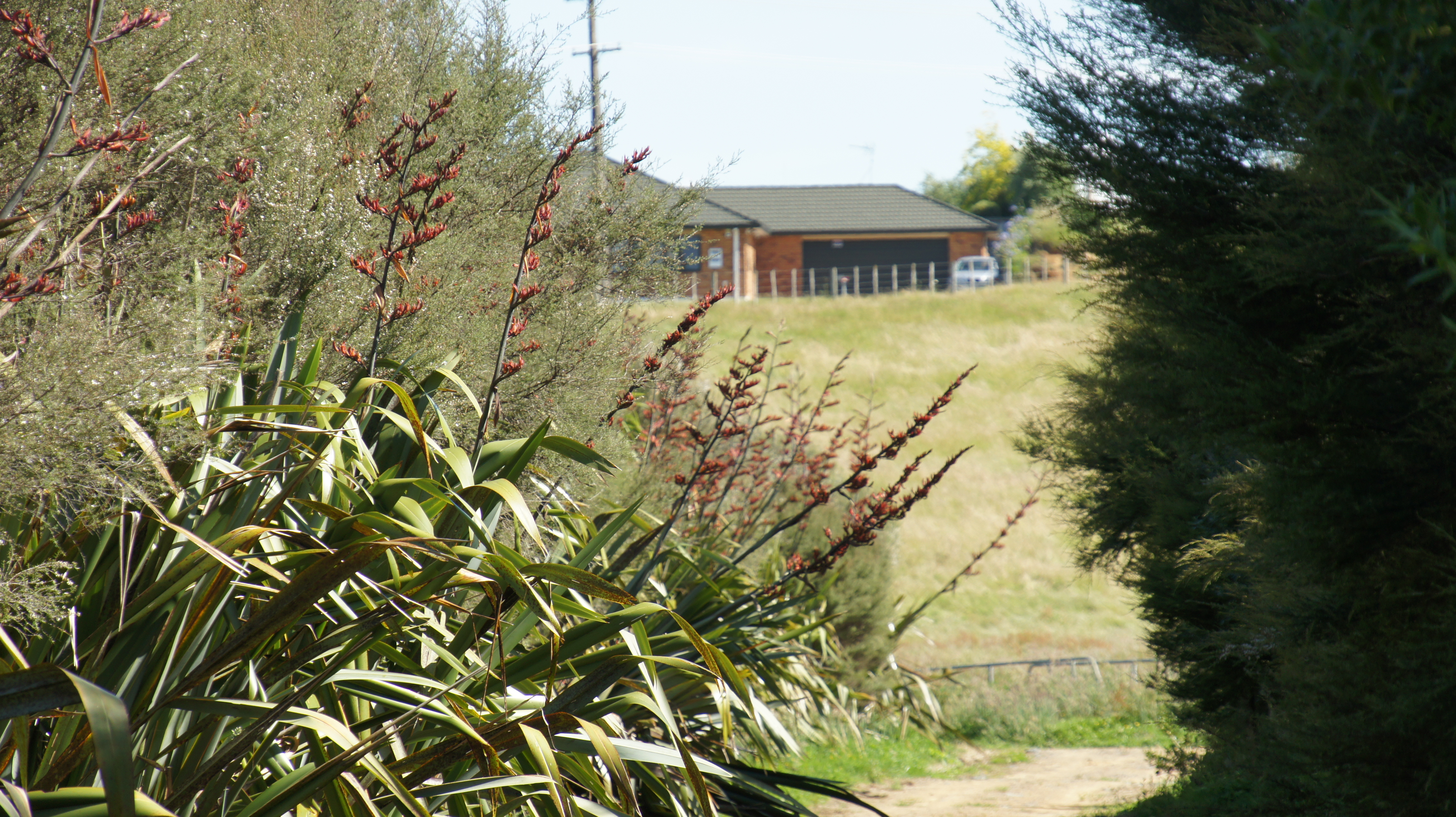
Figure 2. With rapid housing developments in New Zealand, it is important that urban restoration projects are well-planned and efficiently carried out to provide residents with greenspaces to benefit their cultural, health and wellbeing practices. [Photo Catherine Kirby]

In response to a range of housing issues characterised by many as a New Zealand housing crisis, the previous and current government has embarked on several major initiatives to increase the housing stock. A $1B Housing Infrastructure Fund (HIF) was established in October 2016 with provision for interest free loans to local government to enable opening up of new large areas of housing. Many urban centres including Auckland, Tauranga, Hamilton and Queenstown made early applications to the fund. Hamilton City Council was successful in obtaining $290.4 M support for a new greenfield subdivision in Peacocke on the southern edge of the city. This subdivision is intended to enable development of some 3700 houses over the next 10 years and 8100 in 30 years. Approximately 720 ha of peri-urban pastoral agricultural land would eventually be developed (See summary). Coupled with this, and already in progress, is the construction of the Southern Links state highway and local arterial road network. The first proposed subdivision Amberfield covers 105 ha and consent hearings are currently in progress. The environmental impacts of the proposal and how they might be mitigated are being contested. In brief, survival of a small population of the critically endangered Long-tailed Bat (Chalinolobos turberculatus) is the main environmental focus but other aspects including the extent of greenspace and ecological restoration required for ecological compensation are being considered (Figs. 2, 3). With strong political pressure to solve the housing crisis in Hamilton and in other urban centres, making adequate provision for greenspace, especially urban forest, and preventing environmental degradation and indigenous biodiversity decline will be a major challenge.

Figure 3. Aerial photo of Waiwhakareke Natural Heritage Park (65 ha), an award-winning and ongoing ecological restoration project situated on the edge of urban Hamilton. [Photo Dave Norris]

The Predator Free 2050 (PF2050) programme which gained government (National) approval in 2015, aims to eradicate Stoat (Mustela erminea), Ship Rat (Rattus rattus), Norway Rat (Rattus norvegicus) and Possum (Trichosurus vulpecula) from the whole of New Zealand by 2050 (Department of Conservation 2018). PF2050 is now gaining significant traction in urban environments (Figs. 4, 5) with many urban centres having good numbers of community-led projects underway (See PFNZ National Trust map). Crofton Downs in Wellington was New Zealand’s first predator-free community project. Led by Kelvin Hastie this project has effectively reduced predator numbers to the point that some sensitive native birds e.g. Kākā (Nestor meridionalis), have begun to nest in this suburb after an absence of more than 100 years (See RNZ report). Also in Wellington, the Miramar Peninsula (Te Motu Kairangi) has become a focus, because of its advantageous geography, with a goal to make the area predator free by 2019. Possums had already been exterminated in 2006 (www.temotukairangi.co.nz).

Figure 4. John Innes (Wildlife Ecologist, Manaaki Whenua Landcare Research) demonstrating trapping success. Removing pest mammals reduces predation, and also frees up the habitat and resources for our native fauna and flora to flourish. [Photo Neil Fitzgerald]

The One Billion Trees (1BT) programme was initiated by the new coalition government (Labour, NZ First, Greens) in 2017 with $238M released in 2018 for planting of both exotic and native trees across mixed land use types. It is not clear yet whether urban forest projects have received funding support but the guidelines suggest there is no reason why restoration of native forest in urban settings would not be eligible. While the emphasis is on exotic tree plantations, native species and long-term forest protection are increasingly being considered as viable options by the newly established government forestry agency Te Uru Rākau.

The policy setting for ecological restoration in urban environments is potentially becoming more favourable with the draft National Policy Statement on Indigenous Biodiversity (NPSIB) currently in review and the New Zealand Biodiversity Strategy under revision (See terms of reference). The draft NPSIB emphasises restoration of indigenous habitat in biodiversity depleted environments. Specifically, Policy 19: Restoring indigenous biodiversity depleted environments, recommends a target for indigenous land cover, which in urban areas and peri-urban areas must be at least 10 per cent. The revision of the New Zealand Biodiversity Strategy seems likely to give more emphasis to landscape scale restoration including urban environments.

Figure 5. New Zealand native lizards are extremely vulnerable to mammalian predation (e.g. mice, hedgehogs, ferrets, cats) as well as habitat destruction (e.g. new urban developments). [Photo Tony Wills]

Research update. Using the same targeted Google Scholar search method as reported in the EMR feature we have found 18 new peer reviewed papers published between 2015 and July 2019 (see updated bibliography) that are strongly focused on restoration in New Zealand urban environments. The single paper noted for 2015 was missed in our previous search. Again, we have not included books, book chapters or grey literature. This compares very favourably with the total 27 papers listed in our 2016 review of which more than half dated from 2009. An increasing publication rate confirms increasing interest and research efforts in aspects of urban ecological restoration. While most of the publications remain in the ecological science realm there are now some informed by other disciplines including engineering, psychology, landscape architecture and health sciences.

Most notably since our 2016 review, a new government-funded (Ministry of Business, Innovation and Employment) research programme, People, Cities and Nature, began in November of 2016. This four-year $823 k per annum research programme ends in October of 2020 unless a funding rebid to be submitted in March 2020 is successful. The programme undertakes multidisciplinary research in nine NZ cities via six inter-related projects: restoration plantings; urban lizards; mammalian predators; Māori restoration values; green-space benefits and cross-sector alliances. While the emphasis was on the ecological science of urban restoration at the outset, the programme has become increasingly involved in understanding the multiple benefits of urban ecological projects including social cohesion and health and recreation benefits. The need to connect restoration research and practice has been met by undertaking multi-agency and community workshops involving researchers and practitioners in five cities to date with a further four scheduled before the programme ends.

Acknowledgements. The People Cities and Nature research programme is funded by the Ministry of Business Innovation and Employment under grant number UOW1601.

Information. Bruce D. Clarkson, Environmental Research Institute, University of Waikato, Hamilton, New Zealand bruce.clarkson@waikato.ac.nz; Catherine L. Kirby, Environmental Research Institute, University of Waikato, Hamilton, New Zealand catherine.kirby@waikato.ac.nz; and Kiri J. Wallace, Environmental Research Institute, University of Waikato, Hamilton, New Zealand kiri.wallace@waikato.ac.nz.

Waterponding the Marra Creek, NSW rangelands – UPDATE of EMR feature

Ray Thompson and Central West Local Land Services

[Update of EMR feature – Thompson, Ray F (2008) Waterponding: Reclamation technique for scalded duplex soils in western New South Wales rangelands. Ecological Management & Restoration 9:3, 170-181. https://onlinelibrary.wiley.com/doi/10.1111/j.1442-8903.2008.00415.x]

Figure 1.  Scalded country with 30cm of sandy loam topsoil swept away by wind after extensive overgrazing. (Photos NSW SCS)

Introduction. Overgrazing of native pastures in the second half of the 19th Century stripped vegetation and led to the wind erosion of sandy topsoil during inevitable dry periods.  By the 1960s, tens of thousands of square kilometres of rangeland sites in western NSW had a legacy of moderate or severely bare or ‘scalded’ lands. This left bare and relatively impermeable clay subsoil which prevents water penetration and is very difficult for plants to colonize (Fig 1.)

Waterponding is the holding of water on the scald in surveyed horseshoe-shaped banks, each covering 0.4 ha. The ponds retain up to 10 cm of water after rain which leaches the soluble salts from the scalded surface. This improves the remaining soil structure, inducing surface cracking, better water penetration and entrapment of wind-blown seed. Consequently, niches are formed for the germination of this seed and recovery of a range of (typically around 15 out of a total of about 30) locally native chenopod (saltbush) grassland species on the sites.

The original 2008 EMR feature described how barren scalds at a range of properties in Marra Creek, near Nyngan in semi-arid NSW were transformed during the 1980s and 1990s into biodiverse native pastures through a technique called ‘waterponding’ developed after five decades of work by consecutive soil conservation officers exploring a range of prototype treatments.  Over time, a wide range of machines have been used to construct waterponding banks including standard road graders (ridged frame and articulated) or similar. Pre-1985 road graders were generally too small to construct banks of sufficient size, which resulted in too many breached banks. Over a 4-year period, the Marra Creek Waterponding Demonstration Program, backed by committed landowners, researched different horsepower road graders, constructing different size banks, winning the dirt from different locations, and evaluating the economics of construction methods. The results showed that the higher-powered articulated road graders exceeding 200 HP proved to be the most economical and efficient for waterpond construction. This type of machine has the power to  form the bank with one pass on the inside of the bank and two passes on the outside, achieving a bank with well over 2 m base width and over 60 cm in height (Fig. 2).

Figure 2. The process of of waterponding including (a) ute-mounted laser levelling to design the waterpond for a particular site, (b) bulldozing the pond walls to the designed levels, (c) rainfall filling the pond to allow deep watering and cracking of the clay subsoil and (d) resulting revegetation within the walls of the pond. (Photos NSW SCS)

Update and the broader program.  Photos and pasture measurements undertaken on ‘Billabong’ Marra Creek NSW, till 2014 show that the waterponding site had increased ground cover (predominantly native species) from 1% in 2005 to 84 % in 2014. After five to seven rainfall years a typical treatment can result in recovery of up to 15 native species from a range of up to 31 species (Table 1). The method in the last 20 years has also included broadcasting seed of some of the more important perennial species of healthy native chenopod grasslands including  Oldman  Saltbush  (Atriplex nummularia), Bladder Saltbush (Atriplex vesicaria) and Mitchell Grass (Astrebla   lappacea) (Fig 3).  Landholders in the Marra Creek district observe a range of fauna frequently on and between the ponds, including Western Grey Kangaroo (Macropus fuliginosus), Red Kangaroo (Macropus rufus), Emu (Dromaius novaehollandiae), Brolga (Grus rubicunda) and the Eastern Bluetongue Lizard (Tiliqua scincoides). A species of Monitor (Varanus sp.) also sometimes traverses the waterponds. Formal monitoring of smaller reptile and invertebrate use of waterponded sites is yet to occur.

Figure 3. Curly Mitchell Grass (Astrebla lappacea) sown on pond banks. (Photo NSW SCS)

Marra Creek was not the first series of waterponding programs in the Nyngan area – nor the last. The outputs of the entire program by 2019 included over 80,000 waterponds laid out and constructed, resulting in 40,000 hectares returned to local native vegetation. A total of 164 properties in the rangelands area are now using waterponding, the majority of landholders in the Marra Creek district and representing an increase from 17 landholders back in 1984 when we first ran the waterponding.

Figure 4. Landholders themselves are teaching the Waterponding technique to other landholders. (Photos NSW SCS)

Economic model of waterponding. The primary driver for land reclamation was not biodiversity conservation but returning the natural capital of rangelands. As such the program has returned a clear profit to the landholders in terms of increased native pastures that can be grazed, improving ecologically sustainable income sources for farming families.

With the reinstatement of vegetation, there have be increases in total stock feed, resulting in an increase in lambing percentages and wool cuts, as well as the ability to carry stock further into prolonged dry periods with overhead cost per head remaining static. Once rehabilitation has been completed, stocking  rates have been raised from zero to one sheep to 1.5 ha. This iseffectively the long-term grazing average for  saltbush pastures in the Nyngan district.

A treatment involving the full design and survey, pond construction and revegetation cost the landholder about $144.00 per hectare. (This includes approximately $25 a hectare for seed.) If the landholder does all the work the cost is reduced to $72/ha. The type of land involved was calculated in 2008 to normally  have  a  resale  value  of  about $365.00 per hectare In its unproductive state.  Scalded land does not contribute to the farm income yet still incurs rates. Investment in rehabilitation, in contrast, improves carrying capacity thus reducing hand-feeding costs, improving lambing percentages and avoiding forced stock sales. This allows landholders to pass the property to the next generation in a far better condition than it has been previously.

Research has found that the scalds store approximately 18.7 t/h of soil organic carbon to a depth of 30 cm. Once the landscape has been restored by waterponding and revegetation, we have found there is a rapid increase in soil organic carbon up to 25 t/ha within five years. The results are indicating that land in the rangelands that has been rehabilitated using waterponds does sequester carbon. This could lead on to waterponding being eligible for a carbon abatement activity and hopefully lead to Carbon Farming Initiative activity for carbon credits.

Figure 5. Australian National University students attending ‘21 years of participation in Rangelands Waterponding’. (Photos NSW SCS)

Potential for further application. After decades of field days and uptake of the methodologies by local graziers (Fig. 4), waterponding now forms part of standard district farming methodologies and landholders are now passing on knowledge to new generations, including through universities (Fig. 5). The methodologies have also been applied at one national park and one Trust For Nature site in Victoria, and are being applied in the Kimberley, with potential for far greater application in desert conservation reserves throughout Australia and the rest of the world (See Fig. 6 and https://justdiggit.org/approach-2/#).

Contact. Kyra Roach, Central West Local Land Services, Nyngan, 2825 Australia. Email: kyra.roach@lls.nsw.gov.au

Figure 6. A total of 79 trainees from 26 Africa countries (including Ghana, Tunisia, Rwanda, Burundi and Djibouti) over a three year period were sponsored by AusAid to study waterponding in Nyngan. Resullting work in African countries is making a big difference to degraded lands particularly in North Sudan and Kenya (Photo NSW SCS)

Table 1. Species found in waterponds after standard revegetation treatments and five to seven rainfall years. The species found by Rhodes (1987b) are still commonly found, with additional species (marked with a diamond +) observed by Ray Thompson. (Plant names are consistent with the New South Wales Herbarium database PlantNet, http://plantnet.rbgsyd.nsw.gov.au/ and  growth forms are consistent with Cunningham et al. (1981) (Exotics are marked with an asterisk)

Scientific name Common name Growth form
Alternanthera denticulata Lesser Joyweed Annual forb
Astrebla lappacea+ Curly Mitchell Grass Perennial grass
Atriplex leptocarpa Slender-fruited Saltbush Perennial subshrub
Atriplex lindleyi+ Eastern Flat Top Saltbush Annual subshrub
Atriplex nummularia+ Oldman Saltbush Perennial shrub
Atriplex pseudocampanulata Mealy Saltbush Annual subshrub
Atriplex semibaccata+ Creeping Saltbush Perennial subshrub
Atriplex spongiosa Pop Saltbush Annual forb
Atriplex vesicaria Bladder Saltbush Perennial subshrub
Centipeda thespidioides Desert Sneezeweed Perennial forb
Chamaesyce drummondii Caustic Weed Annual or short-lived perennial forb
Chloris truncata Windmill Grass Annual or perennial grass
Diplachne fusca Brown Beetle Grass Perennial grass
Eragrostis parviflora Weeping Lovegrass Annual or short-lived perennial grass
Eragrostis setifolia Neverfail Perennial grass
Hordeum leporinum* Barley Grass Annual grass
Hordeum marinum* Sea Barley Annual grass
Maireana pentagona Hairy Bluebush Perennial subshrub
Malacocera tricornis Soft Horns Perennial subshrub
Marsilea drummondii Common Nardoo Perennial forb
Medicago minima* Woolly Bur Medic Annual forb
Medicago polymorpha* Burr Medic Annual forb
Osteocarpum acropterum+ Water Weed Perennial subshrub
Phalaris paradoxa* Paradoxa Grass Annual grass
Pimelea simplex Desert Rice-flower Annual forb
Portulaca oleracea Common Pigweed Annual forb
Salsola kali var. kali Buckbush Annual or biennial forb
Sclerolaena brachyptera Short-winged Copperburr Short-lived perennia
Sclerolaena calcarata+ Red Copperburr Perennial subshrub
Sclerolaena divaricata+ Pale Poverty Bush Perennial subshrub
Sclerolaena muricata Black Roly-poly Short-lived perennial
Sclerolaena trycuspis Streaked Poverty Bush Perennial subshrub
Sporobolus actinocladus Katoora Grass Perennial grass
Sporobolus caroli Fairy Grass Perennial grass
Tragus australianus Small Burr Grass Annual grass
Tripogon loliiformis+ Five Minute Grass Perennial grass


Addressing ghost nets in Australia and beyond – update of EMR feature

Britta Denise Hardesty, Riki Gunn and Chris Wilcox

[Update of EMR feature  – Riki Gunn, Britta Denise Hardesty and James Butler (2010) Tackling ghost nets: local solutions to a global issue in Northern Australia, Ecological Management & Restoration, 11:2, 88-98. https://onlinelibrary.wiley.com/doi/10.1111/j.1442-8903.2010.00525.x]

Key words.  derelict fishing nets, ghost gear, GGGI, Indigenous livelihoods

Figure 1. Dead turtle caught in a derelict ghost net. (Photo: Jane Dermer, Ghost Nets Australia)

Introduction. The focus of our 2009 feature was to highlight the work of Indigenous rangers in addressing the local but widespread problem of abandoned, lost or derelict fishing gear (ALDFG) in Northern Australia, particularly ‘ghost nets’ that are carried on the currents and continue to fish long after they are no longer actively used (Figs 1-4). We also aimed to raise awareness of the efforts required to address this complex issue, whilst highlighting the work of Indigenous rangers working in the region.  The feature reported ghost net removal efforts taking place in Australia’s Gulf of Carpentaria – which, by 2009, involved the removal of 5532 nets by over 90 Indigenous rangers from more than 18 Indigenous communities.  This highlighted the transboundary nature of the ghost gear issue, and identified that most nets likely originated from beyond Australia’s waters.

Figure 2. Napranum ranger Philip Mango releasing juvenile turtle trapped in ghost net. (Photo: Ghost Nets Australial)

Further work. Since 2010, the understanding of and approaches to addressing the derelict fishing gear issue have increased substantially. This has been reflected both in domestic efforts within Australia, and more broadly in the international community.

Domestically, in the last decade, the ranger program across northern Australia has evolved and grown, enabling more Indigenous people to remain culturally connected to their land and sea country through meaningful employment.  Ranger activities generally involve a range of restoration activities including feral and weed management, in addition to (for  coastal groups) ghost net removal. Across northern Australia, Indigenous ranger groups continue to remove nets on their country, demonstrating the success of the initial program supported by the Australian government. To date, nearly 15,000 ghost nets (three times the number reported in 2010) have been removed from the region. The net removal program has extended beyond Ranger groups working in the Gulf of Carpentaria to include the Torres Strait, the western part of the Northern Territory Coast, and parts of the Kimberly coastline in Western Australia.

Globally, the world is focused on the United Nations Sustainability Development Goals (SDGs) which aims to provide a ‘shared blueprint for peace and prosperity for people and the planet, now and into the future’ (https://sustainabledevelopment.un.org/sdgs).

A key focus for the SDGs is to help preserve the world’s oceans, a topic which touches on food security, poverty and economic growth, among other goals. Ensuring fishing practices are aligned with these goals includes reducing gear losses into the marine and coastal environment. In recognition of the issue and to end ALDFG, there is now a multi-stakeholder alliance of fishing industry, private sector, multinational corporations, non-government organizations, academics and governments, the Global Ghost Gear Initiative (GGGI), which is focused on solving the problem of abandoned, lost and derelict fishing gear worldwide. Both CSIRO and GhostNets Australia were founding members of this alliance and have been instrumental in engagement and scientific endeavours which inform the GGGI.

Fig 3. An enormous effort is invested by Indigenous rangers in removing ghost nets from beaches along the northern Australian coastline (Photo: World Animal Protection/Dean Sewell)

Based on collaborative research between GhostNets Australia and CSIRO, it was determined that the primary source of derelict nets washing ashore along Australia’s northern coastline was the Arafura Sea. Engagement with fishers in the region through a series of workshops identified that major causes of gear loss included snagging of nets and over-capacity in the region. We also identified opportunities to help resolve ghost net issues in the region, though stakeholder engagement, points of intervention and livelihood tradeoffs. Much of this overcapacity and overcrowding has been attributed to illegal, unreported and unregulated (IUU) fishing. Subsequently, Indonesia went through a substantial change in practices with regards to allowing foreign vessels in their waters, effectively closed their borders to foreign fisheries operators. Anecdotally, information from multiple ranger groups in Northern Australia suggests that this highly publicized and significant change in practice has resulted in a substantial decrease in the number of ghost nets washing ashore along at least part of the northern Australian coastline.

Another outcome from the collaborative research effort was a new understanding based on deep citizen science engagement and modelling to identify potential high risk areas where ghost nets were likely to cause the most harm to turtles. In this work, we were able to suggest interdiction points for ghostnets, before they entered the Gulf of Carpentaria where they were likely to kill wildlife. We also identified the nets that were most harmful to wildlife and we estimated that nearly 15,000 marine turtles had likely been killed by derelict nets in the region.

There have also been some technological improvements in this area. These fall into both reporting and in tracking nets. Electronic data collection has improved the quality of data collection and can ensure errors are minimised. Development of the tool has also been designed such that those with reduced literacy are also able to collect valuable information, a feature that can be important in many communities. Using icons and photos to help identify nets improved data reliability.

Also within Australia, alternative livelihoods programs such as Ghost Net Gear evolved into the Ghost Net Art Project where the art works have excited the International art community.  This has resulted in purchases by many internationally renowned purveyors of artwork including the British Museum, the Australian National Museum and the Australian Maritime Museum. Works from Indigenous artists can also be seen at Australia’s Parliament House, and exhibitions have taken place in Monaco, Alaska, Singapore and France as well as in numerous national and regional galleries around Australia. A commemorative stamp was even made from the Ghost Nets artwork that lives in the Australian National Museum.

Figure 4. Large nets can become entangled in coastal vegetation. (Photo: World Animal Protection/Dean Sewell)

Future directions. While GhostNets Australia has not formally continued as a non-governmental organization, many of the components initiated through the program have continued and grown through time, as exemplified above. This early work also helped springboard CSIRO’s engagement in capacity building with the Indonesian government to tackle Illegal, Unreported and Unregulated (IUU) fishing. This had led to a strong research collaboration relationship between the two countries, with a shared goal of reducing IUU fishing, building capacity on marine resource management, and improved monitoring, control and surveillance efforts in Indonesia.

CSIRO is also involved in an aerial (re)survey of the coastline across Northern Australia. In affiliation with World Animal Protection and Norm Duke and Jock Mackenzie from James Cook University, we are looking at changes in the number of ghost nets along the shoreline (Figs 3 and 4). Stereo images were recorded along the entire coastline and we are comparing ghost nets observed across the region with two other aerial surveys that have taken place in the last decade. The team have just completed flights (September 2019), so we are looking forward to analysing the images and comparing ghost net numbers across the region.

ContactDenise.hardesty@csiro.au; CSIRO Oceans and Atmosphere, Hobart, Tasmania, Australia. rikigunn1@outlook.com; chris.wilcox@csiro.au

Registration of domestic cats on Christmas Island, Indian Ocean: stage one to an eradication program for stray and feral cats to mitigate social and environmental impacts – UPDATE of EMR feature

 David Algar, Neil Hamilton and Caitlyn Pink

[Update to EMR article: Algar, David, Stefanie Hilmer, Don Nickels and Audrey Nickels (2011) Successful domestic cat neutering: first step towards eradicating cats on Christmas Island for wildlife protection. Ecological Management & Restoration, 12:2, 93-101. https://onlinelibrary.wiley.com/doi/10.1111/j.1442-8903.2011.00594.x]

Key words: domestic and feral cats, eradication program, cat de-sexing and registration, cat management, pet cat survey, local cat legislation

Figure 1. Stray cat on Christmas Island (Photo Neil Hamilton DBCA)

Introduction: In 2010 a ‘’Cat Management Plan’’ was commissioned by the various land management agencies on Christmas Island to mitigate the environmental and social impacts of cats (Felis catus) on the island (Fig 1). These impacts included contributing towards the decline of a number of native species through predation, as well as being a source of Toxoplasmosis gondii, a parasite that can lead to serious human health complications.

The plan proposed a strategy to eradicate cats entirely from the island as the domestic population died out and was adopted in late 2010. The essential first stage of the management plan was therefore the registration of all domestic cats. As part of this plan, amendments to the Local Cat Management Laws (Shire of Christmas Island Local Law for the Keeping and Control of Cats 2004 (WA)) under the Local Government Act 1995 (WA) were endorsed in August 2010. These revisions required that all domestic cats in the Shire of Christmas Island were legally bound to be de-sexed, tattooed, microchipped and registered with the Shire. The revisions were designed to limit domestic and stray/feral cat impact on the native fauna, promote responsible cat ownership, compliance and enforcement of cat management laws and prohibit the importation of new cats. Micro-chipping of domestic cats would enable the identification of those animals during trapping campaigns for stray and feral cats, so that they could be released rather than destroyed. De-sexing would prevent potential natal recruitment into the domestic, stray and feral populations. A survey of domestic cats was conducted prior to the veterinary program in October 2010 (see original feature), to guarantee that all domestic cats would be registered. One hundred and fifty-two cats were recorded during the initial survey in October 2010 of which 136 were registered as domestic pets.

Figure 2. Red-tailed Tropic-Bird with chick May 2012. (Photo Neil Hamilton DBCA)

Further works undertaken: Two further veterinary visits were conducted in May 2011 and 2012 following the domestic cat surveys to complete the veterinary program. Subsequent domestic cat surveys have been conducted each May in 2013, 2014, 2015 and 2016. In 2016 prior to the domestic cat survey, it came to our attention that a number of un-registered cats were being kept as pets. It was decided by the ‘’Christmas Island Cat Eradication Steering Committee’’ that a short-term amnesty on pet cat ownership be invoked so that these animals could also be de-sexed and registered. Following this amnesty, a final veterinary program was endorsed and fines were still issued to those residents who wanted their otherwise illegal cat to be de-sexed and registered, or unregistered cats could be handed in and euthanased without charge. Further domestic cat surveys were conducted in May 2017 and October 2018.

Further results to date: Since October 2010, 184 cats have been registered following the various veterinary programs. The survey conducted in 2018 recorded 66 registered cats remaining. The total number of domestic cats registered each year, the sex population structure, the number of new registrations and number deregistered are presented in Table 1, with the decline of two-thirds relatively steady over the years.

Table 1. Total number of domestic cats registered each year, the sex structure, the number of new registrations and number de-registered.

Date No. registered New/re-registers De-registers
  Total Female Male Total Female Male Total Female Male
October 2010 N/A N/A N/A 136 66 70 N/A N/A N/A
May 2011 138 69 69 18 10 8 16 7 9
May 2012 135 66 69 12 5 7 15 8 7
May 2013 111 53 58 0 0 0 24 13 11
May 2014 101 50 51 0 0 0 10 5 5
May 2015 87 45 42 0 0 0 14 5 9
May 2016 75 41 34 2 1 1 14 5 9
June 2016 93 49 44 18 8 10 0 0 0
May 2017 74 38 36 1 0 1 20 11 9
October 2018 66 36 30 0 0 0 8 2 6

Lessons learned and future directions: At the conclusion of the domestic cat survey in 2018, there were 66 registered cats present on the island. An additional seven domestic cats are known to have died before the planned 2019 domestic cat survey. Death of registered cats over the past nine years has been caused by a number of factors including: road fatalities; old age; disease; requests for cats to be euthanased for a variety of reasons and cats exported back to the mainland.

Domestic cats will remain on Christmas Island for a number of years, with the youngest cat approximately three years of age. Initially, as reported in the 2011 feature, it was predicted that the island would be domestic cat-free by 2024 however, this is unlikely given the subsequent and final veterinary program in 2016.

Further amendments to the island’s cat local laws were adopted in 2018, following consultation with the community and the Christmas Island Cat Eradication Steering Committee. This included an increase in penalties for illegal unregistered cats and compulsory transfer of ownership procedures to prevent future movement of registered pet cats into the designated pet cat prohibited zone. This zone protects nesting habitat for the ground-nesting Red-tailed Tropic Bird (Phaethon rubricauda, Fig 2.), where cat predation led to 90% failure of fledgling rates pre-control. Subsequent cat management in this zone has been successful in improving fledgling survival (See 2012 report).

There are several benefits of repeating the domestic cat survey each year as pet numbers decline: continue program awareness to all residents; maintain community support and involvement; offer pet health advice; thoroughly check for illegal cats to report to the Shire and respond to stray cat reports within the township. This continued effort will help ensure there is little opportunity or temptation to obtain new kittens as illegal pets while later stages of the eradication are progressing, and responsible cat ownership is maintained until the domestic cat population has died out.

The goal of eradicating cats remains highly relevant and is supported by the island community, local land management agencies and the federal government. The feasibility of long-term success is high and the outcome is likely to provide valuable lessons for other jurisdictions with social and environmental issues surrounding the presence of feral and domestic cats.

Stakeholders and Funding bodies: This is a collaborative project between Western Australian Department of Biodiversity, Conservation and Attractions and Parks Australia. The authors would like to thank Parks Australia, Christmas Island Phosphates, Shire of Christmas Island, Department of Infrastructure, Transport, Cities and Regional Development and Australian Border Force for their financial, in-kind and logistical support. Special thanks to Robert Muller, Khaleisha Amin and Chris Su for their assistance in annual surveys. The warm welcome and assistance of the whole Christmas Island community during all domestic cat surveys has been appreciated.

Contact information: David Algar, Biodiversity and Conservation Science, Department of Biodiversity, Conservation and Attractions (Locked Bag 104, Bentley Delivery Centre, Western Australia, Australia 6983) Email: dave.algar@dbca.wa.gov.au


Ecological restoration and rehabilitation at Sydney Olympic Park – UPDATE to EMR feature

Jennifer O’Meara and Kerry Darcovich

[Update to EMR feature – O’Meara, Jennifer and Kerry Darcovich (2015) Twelve years on: Ecological restoration and rehabilitation at Sydney Olympic Park, Ecological Management & Restoration, 16:1, 14-28. https://onlinelibrary.wiley.com/doi/10.1111/emr.12150 ]

Keywords: Environmental management, ecological management, threatened species, Habitat management , woodland birds, Green and Golden Bell Frog

Introduction. The 2015 EMR feature described ecological restoration and management works at Sydney Olympic Park, a large urban park containing both remnant and constructed landscapes that underwent significant restoration in preparation for the 2000 Olympic Games. Sydney Olympic Park supports a rich natural environment that includes over 250 native animal species, over 400 native plant species and three endangered ecological communities.  The high ecological values of the Park have resulted in 304 hectares (nearly half of the Park) being zoned under NSW planning legislation for environmental conservation and management.  Key habitats include estuarine and freshwater wetlands, remnant eucalypt forest, saltmarsh meadows and woodland bird habitats.

The Park’s biodiversity is of high conservation significance, and makes a significant contribution to the social and economic values of the Park.  The Park’s natural environments enrich visitor experience, provide a living classroom for environmental education programs, and attract businesses and residents seeking proximity to nature. This project began in 2000 when management transferred from a construction phase after the Sydney Olympic Games to an active management phase and is supported by an extensive long term ecological monitoring program. This update summarises new works and outcomes since 2016.

Further works undertaken. The introduction of new ecological infrastructure for frog habitat targets threatening processes of predation by introduced fish and increasing water availability.  Fish-proof fences have been introduced to wetlands where the predatory fish Gambusia (Gambusia holbrooki) is present in Green and Golden Bell Frog (Litoria aurea) habitat (Fig 1). The fences are placed around ponds or pond clusters and then the pond is dried out and refilled with fish-free water. Constructed of sediment fences 600mm high and embedded in the ground, these fences stretch to a maximum of 200m and have successfully restricted the fish from ponds for more than three years.

Figure 1.  Gambusia fence

In order to reduce the impact of bird predation on tadpoles in key breeding ponds, bird netting secured by wire cables to the ground and supported by hoops has been introduced.  The netting is also used as a response to the sighting of Green and Golden Bell Frog tadpoles in ponds with Sydney Olympic Park staff deploying temporary netting where successful breeding has occurred. Netting is left on the pond until all metamorphs have dispersed from the pond then removed.

Restoration of the water-holding capacity and connectivity of bell frog habitat in the Brickpit and Kronos Hill has been improved with temporary ponds being created with tarps (Fig 2). The aim is twofold – to extend the number of predator-free, drought refuges, important for adult female frogs and metamorphs and to ensure frog corridors maintain connectivity.  More than 10 tarp ponds have been created and have an expected life span of 3-6 years and are very budget friendly. Annual monitoring has shown a remarkable uptake of these ponds by the Green and Golden Bell Frog.

Figure 2.  Tarp pond with netting

Further results to date. The Parks ecological monitoring program is ongoing and now entering the 16th consecutive year for birds, 15th for reptiles and 21 years for the Green and Golden Bell Frog. In 2018-19 the fourth woodland bird survey was completed, a four yearly assessment of the status of woodland birds and vegetation management at Sydney Olympic Park. Fifteen quadrats are surveyed over the spring and autumn seasons to measure bird communities which is then compared to change in vegetation structure. Results show that small birds were strongly, positively correlated with shrub cover, but strongly negatively correlated with tree cover and Noisy Miner (Manorina melanocephala).  Since 2006, Sydney Olympic Park Authority has implemented a habitat modification program aimed at increasing the structural diversity and complexity of key areas of the Park to support woodland birds. The program seeks to build connectivity between key woodland bird habitats with the form of habitat enhancement varying depending on site characteristics. The survey shows that this program is successfully creating suitable habitat for this group of birds.

With the prospect of greater demands by the public to access the Park at all hours (see below), Sydney Olympic Park staff have recently collected baseline light level readings from across the Park to inform decision making.  Data on lux levels and light source was collected from over 160 sites ranging from car parks to mangrove creeks. The main drive of the survey was to collect information on light spill into sensitive habitat areas where darkness is a key ecological feature. The survey led to a review of lighting and identification of where lights could be switched off or timed to decrease light impacts. The findings will also inform future planning for illumination within the Park.

Lessons learned and future directions. Sydney Olympic Park is part of a rapidly densifying area with the 30,000 residents currently located within a 3km radius forecast to increase to approximately 100,000 in ten years. Due to the density of housing, Sydney Olympic Park will be/is already the local park for this community, leading to increasing demand for recreation and access to the Parklands. This presents great opportunities for more people to connect with nature and to incorporate community education and sustainability into Park programs.  A new program known as Park Care has been launched recently and currently rolls out community clean up and revegetation activities.

The flipside of this rapid population increase is increasing risk of disturbance to ecologically sensitive areas which needs to be considered and mitigated carefully as the Park continues to evolve. Ensuring the Park is able to sustainably meet this demand is a focus for management now and into the future. New habitat management plans for ecologically sensitive areas of the Park are being developed to better-guide biodiversity conservation on a precinct level. Ongoing ecological management works, and managing the impacts of human disturbance, will be essential to conserving the ecological values of the Park.

Contact. Jennifer O’Meara, Parklands Ecologist, Sydney Olympic Park Authority, 5 Olympic Boulevard, Sydney Olympic Park 2127 NSW, Australia. Email: Jenny.omeara@sopa.nsw.gov.au

Developments in Big Scrub Rainforest Restoration: UPDATE of EMR feature

Tony Parkes, Mark Dunphy, Georgina Jones and Shannon Greenfields

[Update of EMR feature article: Parkes, Tony, Mike Delaney, Mark Dunphy, Ralph Woodford, Hank Bower, Sue Bower, Darren Bailey, Rosemary Joseph, John Nagle, Tim Roberts, Stephanie Lymburner, Jen Ford and Tein McDonald (2012) Big Scrub: A cleared landscape in transition back to forest? Ecological Management & Restoration 12:3, 212-223. https://doi.org/10.1111/emr.12008]

Key words: Lowland Subtropical Rainforest, ecological restoration, seed production, landholder action, corridors

Figure 1a. Rainforest regenerators undertake camphor injection, leaving bare trees standing creating light and an opportunity for seed in the soil to naturally regenerate. (Photo © Envite Environment)

Figure 1b Aerial photo showing camphor conversion by injection
(Photo © Big Scrub Regeneration Pty. Ltd.)

Introduction. The Big Scrub, on the NSW north coast, was once the largest tract of Lowland Subtropical Rainforest (LSR) in Australia. It was reduced to less than 1% of its original extent by he end of hte 19th century after clearing for agriculture. Big Scrub Landcare (BSL) is a non-profit organisation dedicated to improving the long-term ecological functionality of what remains of this critically endangered ecosystem –  lowland subtropical rainforest.  Our 2012 EMR feature reported on remnant restoration and revegetation works overseen by BSL to 2012. At that time, 68 remnants were identified as significantly affected from the impacts of environmental degradation including weed invasion and cattle access. These remnants had been undergoing treatments, with 20 substantially recovered and on a ‘maintenance’ regime.  Approximately 900,000 trees had been planted to establish 250 ha of young diverse well-structured rainforest.  A comparatively small area of forest dominated by the highly invasive exotic, Camphor Laurel (Cinnamomum camphora) (Camphor), which  has colonised much of the Big Scrub landscape had been converted to early phase LSR by skilled removal of a range of weeds and facilitating natural regeneration. 

Progress since 2012. Substantial progress in restoring critically endangered lowland subtropical rainforest in the Big Scrub has been achieved over the past seven years in the following areas.

  • Assisted regeneration of remnants has continued and become more focused
  • Re-establishment of LSR through plantings has expanded
  • Camphor conversion has developed in scale and techniques
  • Greater security of funding has been achieved
  • Community engagement has greatly improved and expanded
  • Genome science is being applied to produce seed with optimal genetic diversity for rainforest restoration.

Assisted regeneration of remnants. This work continues to be the major focus of on-ground restoration work. About 2000 regenerator days (9 years Full Time Equivalent) of work has been undertaken in 45 remnants. BSL’s remnant restoration program has become more strategic, with more focus on Very High Conservation Value (VHCV) remnants, particularly those in the NSW National Parks Estate, including the VHCV sites in Nightcap National Park (NP) including Big Scrub Flora Reserve, Minyon Falls and Boomerang Falls; Andrew Johnston’s Scrub NR; Snow’s Gully Nature Reserve (NR); Boatharbour NR; Victoria Park NR and Davis Scrub NR, plus the Booyong Flora Reserve. Rehabilitation work at these sites is prioritised in the major new four-year Conservation Co-funding project funded jointly by BSL and the NSW government’s Saving our Species program. Big Scrub Foundation (BSF) funding has enabled BSL to continue maintenance work in remnants that have reached or are approaching the maintenance stage.

Monitoring outcomes has become more rigorous and has demonstrated ongoing improvements in vegetation structure, with decreasing levels of weed invasion and improvements in native species cover.

BSL’s partner Envite Environment, with some assistance from BSL, is creating an important linkage between Nightcap NP and Goonengerry NP by the restoration of rainforest through the progressive removal of weeds that had dominated the 80 ha Wompoo/Wanganui corridor between these two NPs.

 Re-establishment of rainforest by planting. The area of LSR is being re-established by planting on cleared land has also continued to expand.   In the last 7 years  more than 0.5 million rainforest trees have been planted in the Big Scrub region, contributing to the restoration of another 175 ha of LSR, expanding total area of re-established rainforest by another 13%. While landscape-scale landholder driven work is inevitably opportunistic rather than strategic, the establishment of new patches of LSR enhance valuable stepping-stone corridors across the Big Scrub. Since 2012 the number of regenerators working fulltime in the Big Scrub region has increased by approximately 50%.  Another trend that has strengthened in the last 7 years is that larger plantings are now being carried out by well-resourced landowners. This is accounting for about 40% of the annual plantings. Offsets for residential development account for another 40% of trees planted. The remaining 20% is made up by small landowners, cabinet timber plantations, large-scale landscaping, and other planting of Big Scrub species. This is a significant change from the more dominant grant-based small landowner/Landcare group plantings prior to 2012.

 Camphor conversion. Larger areas of Camphor forest are being converted to rainforest, with project areas increasing substantially from less than a hectare to ten and twenty hectares. BSL estimates that more than 150 ha of Camphor forest are currently under conversion. Some landowners underake camphor injection which leaves bare trees standing, creating light and an opportunity for existing native seedlings and seed in the soil (or seed dropped by perching birds) to naturally regenerate (Fig 1). Others are choosing the more expensive option of physically removing the Camphor trees and carefully leaving the rainforest regrowth (Fig 2).  Improved techniques and landholder capacity building continue to progress and camphor conversion is now a significant component of rainforest restoration.

BSL alone is facilitating the conversion of almost 40 ha of Camphor forest to LSR funded by two 3-year grants from the NSW Environmental Trust, together with contributions from the 19 landholders involved in these projects. The ecological outcomes being achieved are significant and less costly than revegetation via plantings.

Figure 2a. Camphor forest under conversion using heavy machinery leaving rainforest regrowth intact (Photo © Big Scrub Landcare)

Figure 2b. Aerial photo showing camphor conversion by removal
(Photo © Big Scrub Landcare)

Greater security of funding. Australian Government funding for biodiversity conservation is at a very low level. Competition for existing NSW state government funding is increasing. BSL therefore has continued to  develop new strategies for fund raising to ensure continuity of its long-term program for the ecological restoration of critically endangered LSR in the Big Scrub and elsewhere. Ongoing funding of at least $150,000 annually is needed to ensure the great progress made  over the past 20 years in rehabilitating remnants is  maintained and expanded to new areas of large remnants. These funds finance weed control and monitoring; weeds will always be a part of the landscape and an ongoing threat to our rainforest remnants.

Establishment of the Big Scrub Foundation in 2016 was a major development in BSL’s fund raising strategy. The Foundation received a donation of AUD $1M to establish a permanent endowment fund that is professionally invested to generate annual income that helps finance BSL’s remnant care program and its other activities. Generous donors are also enabling the Foundation to help finance the Science Saving Rainforest Program.

Figure 3a. Australian gardening celebrity Costa Gregoriou at a Big Scrub community tree planting (part of the 17th annual Big Scrub Rainforest Day) in 2015 (Photo © Big Scrub Landcare)

Figure 3b. Founder of the Australian Greens political party Bob Brown and Dr. Tony Parkes at the 18th annual Big Scrub Rainforest Day in 2016. (Photo © Big Scrub Landcare)

Community engagement. The  Big Scrub Rainforest Day continues to be BSL’s  major annual community engagement event, with the total number of attendees estimated to have exceeded 12,000 over the past 7 years; the 2016 day alone attracted more than 4000 people (Fig 3). Every second year the event is held at Rocky Creek Dam.  A new multi-event format involving many other organisations has been introduced on alternate years.

BSL’s Rainforest Restoration Manual has been updated in the recently published third edition and continues to inform and educate landowners, planners and practitioners.

BSL in partnership with Rous County Council produced a highly-commended book on the social and ecological values of the Big Scrub that has sold over 1000 copies. BSL’s website has had a major upgrade: its Facebook page is updated weekly; its e-newsletter is published every two months. BSL’s greatly improved use of social media is helping to raise its profile and contribute to generating donations from the community, local businesses and philanthropic organisations to fund its growing community education and engagement work and other activities.

Science saving rainforests program. BSL, the Royal Botanic Gardens Sydney, the BSF and their partners have commenced an internationally innovative program to apply the latest DNA sequencing and genome science to establish plantations to produce seed of key species with optimal genetic diversity for the ecological restoration of critically endangered lowland subtropical rainforest. This program will for the first time address the threat posed by fragmentation and isolation resulting from the extreme clearing of Australia’s LSR, which is estimated to have resulted in the destruction of 94% of this richly biodiverse Gondwana-descended rainforest.

Many  key  LSR species are trapped in small populations in  isolated remnants  that  lack the genetic diversity needed to adapt and survive in the long term, particularly faced with climate change Necessary  genetic diversity is also lacking in many key species in the 500 ha of planted and regrowth rainforest. The first stage of the program, already underway, involves collecting leaf samples from approximately 200 individual old growth trees in 35 remnant populations across the ranges of 19 key structural species of the ‘original’ forest. DNA will be extracted from the leaf samples of each species and sequenced. The  latest genome science will be applied to select the 20 individual trees of each species that will be cloned to provide planting stock with optimal genetic diversity for the establishment of a living seed bank in the form of a plantation that will produce seed  for use in restoration plantings. As the individual trees in the restoration plantings reproduce, seed with appropriate genetic diversity and fitness will be distributed across the landscape. The project focuses on key structural species and thus helping the survival of Australia’s critically endangered Lowland Subtropical Rainforest in the long term.

Lessons learned and current and future directions. A key lesson learned some five years ago was that BSL had grown to the point where volunteers could no longer manage the organisation effectively. BSL took a major step forward in 2015 by engaging a part-time Manager, contributing to BSL’s continuing success by expanding the scope, scale and effectiveness of its community engagement activities and improving its day to day management.

The principal lesson learned from BSL’s on-ground restoration program is to focus on rehabilitation of remnants and not to take on large planting projects, but rather support numerous partnered community tree planting events. Large grant-funded multi-site tree planting projects are too difficult to manage and to ensure landholders carry out the necessary maintenance in the medium to long term.

Acknowledgements.  BSL acknowledges our institutional Partners and receipt of funding from the NSW government’s Saving our Species program, NSW Environmental Trust and Big Scrub Foundation.

Contact:  Shannon Greenfields, Manager, Big Scrub Landcare (PO Box 106,  Bangalow NSW 2479 Australia; . Tel: +61 422 204 294; Email: info@bigscrubrainforest.org.au Web: www.bigscrubrainforest.org.au)

Recovering Murray-Darling Basin fishes by revitalizing a Native Fish Strategy – UPDATE of EMR feature

John Koehn, Mark Lintermans and Craig Copeland

[Update of EMR Feature: Koehn JD, Lintermans M, Copeland C (2014) Laying the foundations for fish recovery: The first 10 years of the Native Fish Strategy for the Murray‐Darling Basin, Australia. Ecological Management & Restoration, 15:S1, 3-12. https://onlinelibrary.wiley.com/doi/10.1111/emr.12090]

Key words restoration, native fish populations, threatened species, Australia, Murray-Darling Basin

Figure 1. The construction of fishways can help restore river connectivity by allowing fish movements past instream barriers. (Photo: ARI.)

 Introduction. Fish populations in the Murray-Darling Basin (MDB), Australia, have suffered substantial declines due to a wide range of threats and there is considerable concern for their future. Given these declines and the high ecological, economic, social and cultural values of fish to the Australian community, there is a need to recover these populations. In 2003, a Native Fish Strategy (NFS) was developed to address key threats; taking a coordinated, long-term, multi-jurisdictional approach, focussed on recovering all native fish (not just angling species) and managing alien species. The strategy objective was to improve populations from their estimated 10% of pre-European settlement levels, to 60% after 50 years of implementation.

To achieve this the NFS was intended to be managed as a series of 10-year plans to assist management actions in four key areas; the generation of new knowledge, demonstration that multiple actions could achieve improvements to native fish populations, building of a collaborative approach, and the communication of existing as well as newly-acquired science. The NFS successfully delivered more than 100 research projects across six ‘Driving Actions’ in its first 10 years, with highlights including the implementation of the ‘Sea to Hume’ fishway program (restoring fish passage to >2 200 km of the Murray River, Fig 1), improved knowledge of fish responses to environmental water allocations, development of new technologies for controlling alien fish, methods to distinguish hatchery from wild-bred fish, creating a community partnership approach to ‘ownership’ of the NFS, and rehabilitating fish habitats using multiple interventions at selected river (demonstrations) reaches.  The NFS partnership involving researchers, managers, policy makers and the community delivered an applied research program that was rapidly incorporated into on-the-ground management activities (e.g. design of fishways; alien fish control, environmental watering; emergency drought interventions). The NFS largely coincided with the Millennium Drought (1997-2010) followed by extensive flooding and blackwater events, and its activities contributed significantly to persistence of native fish populations during this time.

Funding for the NFS program ceased in 2012-13, after only the first decade of implementation but the relationships among fishers, indigenous people and government agencies have continued along with a legacy of knowledge, development of new projects and collaborative networks with key lessons for improved management of native fishes (see http://www.finterest.com.au/).

Figure 2. Recreational fishers are a key stakeholder in the Murray-Darling Basin, with a keen desire to have sustainable fishing for future generations. (Photo: Josh Waddell.)

Further works undertaken. Whilst the NFS is no longer funded as an official project, many activities have continued though a range of subsequent projects; some are highlighted below:

  • Environmental water: development of fish objectives and implementation of the Basin Plan, northern MDB complementary measures, further investigation of mitigation measures for fish extraction via pumps and water diversions.
  • Fishways: Completion of sea to Lake Hume fishway program and other fishways such as Brewarrina
  • Community engagement: Continuation of many Demonstration (recovery) reaches and intermittent NFS Forums (Fig 2).
  • Recreational fishery management: engagement of anglers through the creation of the Murray Cod (Maccullochella peelii) fishery management group and OzFish Unlimited.
  • Threatened species recovery: success with Trout Cod (Maccullochella macquariensis)  (Fig 3) and Macquarie Perch (Macquaria australasica) populations, development of population models for nine MDB native fish species.
  • Knowledge improvement: research has continued, as has the publication of previous NFS research-related work.
  • Indigenous and community connection to fishes: development of the concept of Cultural flows, involvement in Basin watering discussions.

Figure 3. Trout Cod are a success story in the recovery of Australian threatened species. (Photo: ARI.)

Further results to date. The continued poor state of native fishes means there is a clear need for the continuation of successful elements of the NFS. There is need, however, for revision to provide a contemporary context, as some major changes have occurred over the past decade. The most dramatic of these, at least publicly, has been the occurrence of repeated, large fish kills (Fig 4). This was most evident in the lower Darling River in early 2019 when millions of fish died. The media coverage and public outcry followed the South Australian Royal Commission and two ABC 4Corners investigations into water management, highlighted that all was not well in the Murray-Darling Basin. Indeed, following two inquiries, political recommendations were made to develop a Native Fish Recovery Management Strategy (NFMRS), and a business case is currently being developed. The drought, water extraction and insufficient management efforts to support native fish populations, especially within a broader sphere of a ‘new’ climate cycle of more droughts and climatic extremes, have contributed to these fish kill events. For example, one of the necessary restoration efforts intended from the Basin Plan was to provide more water for environmental purposes to improve river condition and fish populations. Recent research, however, appears to indicate that flow volumes down the Darling River have generally decreased. There is also a continuing decline of species with examples such as Yarra Pygmy Perch (Nannoperca obscura), now being extinct in MDB, and the closely related Southern Pygmy Perch (Nannoperca australis) which is still declining. Monitoring of fish populations has indicated that they remain in poor health and the need for recovery may be even greater than in 2003. We need to act now.

While some of the legacy of the NFS has continued, there has been a loss of integrated and coordinated recovery actions that were a key feature of the NFS. This loss of a Basin-wide approach has resulted in some areas (e.g. small streams and upland reaches) being neglected, with a concentration on lowland, regulated river reaches. There has also been a shift from a multi-threat, multi-solution approach to recovery, to a narrower, flow-focussed approach under the Basin Plan. In addition, there has been the installation of infrastructure (known as Sustainable Diversion Measures) to ‘save’ water which may have deleterious impacts on fish populations (e.g. the impoundment of water on floodplains by regulators or the changed operations of Menindee Lakes on the Darling River).

A clear success of the NFS was improvements in community understanding of native fishes and their engagement in restoration activities. These community voices- indigenous, conservation, anglers, etc. have been somewhat neglected in the delivery of the Basin Plan. There has been ongoing fish researcher and stakeholder engagement, but this has been largely driven by enormous goodwill and commitment from individuals involved in the collaborative networks established through the NFS. While these efforts have been supported by many funding bodies and partners such as the Murray-Darlin Basin Authority, state and Commonwealth water holders and agencies and catchment management authorities, without true cross-basin agreement and collaboration the effectiveness of these efforts will be significantly reduced.

Figure 4. Fish kills have created great public concern and are an indication of the need for improved management of native fish populations. (Photo:Graeme McRabb.)

Lessons learned and future directions.  Native fish populations in the MDB remain in a poor state and improvements will not be achieved without continued and concerted recovery efforts. Moreover, a 5-year review of the NFS indicated that while the actions undertaken to that time had been positive, they needed to be a scaling up considerably to achieve the established goals.  Recovery actions must be supported by knowledge and the lessons learnt from previous experience.  Some fish management and research activities have continued under the auspices of the Basin Plan, but these have largely focussed on the delivery of environmental water, either through water buy-backs or improved efficiency of water delivery. A key requirement is therefore transparent and accurate measurement and reporting of how much flow has been returned to the environment, and how this may have improved fish populations. This remains problematic as evidenced by the recent inquiries into fish kills in the lower Darling River (and elsewhere) and the lack of available water accounting. Fish kills are likely to continue to reoccur and the lingering dry conditions across much of the Northern Basin in 2018-19 and climate forecasts have highlighted the need for further, urgent actions through an updated NFS.

The NFS governance frameworks at the project level were excellent and while some relationships have endured informally, there is a need for an overarching strategy and coordination of efforts across jurisdictions to achieve the improved fish outcomes that are required. The absence of the formal NFS thematic taskforces (fish passage, alien fishes, community stakeholder, demonstration reaches etc) and the absence of any overarching NFS structures means that coordination and communication is lacking, with a focus only on water, limiting the previously holistic, cross jurisdiction, whole-of-Basin approach. The priority actions developed and agreed to for the NFS remain largely relevant, just need revitalized and given the dire status of native fish, scaled up significantly.

Stakeholders and funding. The continuation of quality research and increased understanding of fish ecology, however, not have kept pace with the needs of managers in the highly dynamic area of environmental watering. The transfer of knowledge to managers and the community needs to be reinvigorated. Efforts to engage recreational fishers and communities to become stakeholders in river health are improving (e.g. OzFish Unlimited: https://ozfish.org.au; Finterest website: http://www.finterest.com.au/) but with dedicated, increased support, a much greater level of engagement would be expected.  Previously, the community stakeholder taskforce and Native Fish coordinators in each state provided assistance and direction, including coordination of the annual Native Fish Awareness week. Some other key interventions such as the Basin Pest Fish Plan have not been completed and recovery of threatened fishes have received little attention (e.g. no priority fish identified in the national threatened species strategy).  Funding for fish recovery is now piecemeal, inadequate and uncoordinated, despite the growing need. The $13 B being spent on implementation of the Basin Plan should be complemented by an appropriate amount spent on other measures to ensure the recovery of MDB fishes.

Contact information. John Koehn is a Principal Research Scientist at the Arthur Rylah Institute for Environmental Research, Department of Environment, Land, Water and Planning, was an author the Murray-Darling Basin Native Fish Strategy and a member of various Native Fish Strategy panels and projects (Email:  John.Koehn@delwp.vic.gov.au). Mark Lintermans is an Associate Professor at Institute for Applied Ecology, University of Canberra, and was a member of various Native Fish Strategy panels and projects; (Email: Mark.Lintermans@canberra.edu.au). Craig Copeland is the CEO of OzFish Unlimited and a leading contributor to the development of the next stage of the Native Fish Strategy, the Northern Basin Complementary Measures Program and the 2017 MDB Native Fish Forum (Email: craigcopeland@ozfish.org.au).