Category Archives: Freshwater aquatic

Still repairing wetlands of the Lower Murray: continuing the learning – UPDATE of EMR feature

Anne Jensen

[Update to EMR feature – Jensen, Anne (2002) Repairing wetlands of the Lower Murray: Learning from restoration practice. Ecological Management & Restoration, 3:1, 5-14. https://onlinelibrary.wiley.com/doi/10.1046/j.1442-8903.2002.00092.x]

Key words:         Environmental water requirements, regeneration, wetlands, black box seedlings, Lower Murray Valley

Figure 1. Location of the Lower Murray Valley in South Australia (Map A. Jensen)

Introduction. As highlighted in the original EMR feature this summary is updating, in the Lower Murray Valley 1100 wetlands have been identified in 250 hydrologically-linked complexes (Fig. 1). They have undergone major changes to their water regime over the last 100 years, altering the timing, frequency and duration of floods. Wetlands at lower elevations have become permanently flooded by stable river levels and wetlands at higher elevations are ‘droughted’ by much reduced flooding. All would benefit from environmental watering, to fill gaps in breeding and regeneration cycles.

Our 2002 feature showed that, from 1998 to 2002, the not-for-profit conservation company Wetland Care Australia coordinated on-ground projects to repair priority wetlands in the Lower Murray. The Gurra Gurra project was the largest of these projects, with engineering works at 17 sites to restore multiple flowpaths through the 3000 ha floodplain complex.

Key funding from the National Heritage Trust terminated in 2002 and Wetland Care Australia relocated in 2003 to northern New South Wales, where project funding for wetland projects was still available. However, individuals involved with the Wetland Care Australia projects remained in the Lower Murray Valley in other jobs, so the intellectual property was retained and wetland conservation activities continued.

In 2002, the extent and severity of drought conditions in the Murray River Valley were just being recognised. By 2004, a survey estimated that >75% of the two main tree dominants in floodplain woodlands –  River Red Gum (Eucalyptus camaldulensis) and Black Box (E. largiflorens)  – were dead, dying or extremely stressed along 700 km of the Murray River Valley . The Millenium Drought (2000-2010) caused extreme stress to both ecological and human communities. Government agencies commenced emergency environmental watering from 2004 through the Living Murray program to limit catastrophic damage at eight iconic sites but millions of mature eucalypts were lost from floodplain woodlands along river valleys.

The Millenium Drought changed the governance context radically, with the Water Act 2007 establishing a new Murray-Darling Basin Authority and the Basin Plan. The Commonwealth Environmental Water Holder (CEWH) was able to purchase water for environmental use.

Nature delivered life-saving floods in 2010-12, which broke the drought and sent flows through the Gurra Gurra complex flowpaths, so the works completed back in 2000 finally fulfilled their function (Fig. 2). Water flowed through the pipes at Tortoise Crossing for 170 days in 2010-11 and again for 71 days in 2012.

Figure 2. The sign at the key Tortoise Crossing flow path explains that replacing three pipes with 160 pipes back in 2000 now allows 50 times more flow when the river floods, as seen at the flood peak in December 2016 (Photos A. Jensen)

The sequence of floods led to mass germination of Black Box at medium floodplain elevations, with mass River Red Gum seedlings at lower elevations. A range of studies show that the survival of these seedlings is critical to fill age gaps and replace the losses from the Millenium Drought, as survival rates from germination events in the 1970s and 1990s were very poor and the last successful mass recruitment of Black Box in the Lower Murray Valley was from the 1955-56 floods.

Following the floods in 2010-2012, conditions were dry in 2013-15 and the fields of mass seedlings began to dry out and die. A further short flood in 2016 watered the surviving fields of Black Box seedlings for at least two weeks, adding to prospects of survival and flowing through the Tortoise Crossing pipes for 75 days. However, conditions in 2018-19 and into summer 2019-20 are once again extremely dry, with stress appearing in mature trees and saplings dying off. The Lower Murray Valley is still recovering from the Millenium Drought, thus needing more frequent watering over a sequence of years to bring mature trees back to health and full seed production, so this is a significant setback.

Further works and activities since 2002. Since 2008, the environmental charity Nature Foundation SA (NFSA) has been undertaking environmental watering projects on smaller, privately-owned sites in the Lower Murray, many from the original Wetland Care Australia list. In the Lower Murray Valley, water needs to be lifted up to 3 m from the river channel to reach wetlands on the floodplain, requiring costly energy. This is done using irrigation techniques, including pumps, pipes and sprinklers. These smaller projects complement government agency projects using major infrastructure to deliver environmental water to much larger wetland complexes.

In 2008-09, the primary purpose was to acquire water and use it to limit extreme environmental damage in the drought. In 2009 NFSA provided supplementary water for Little Duck Lagoon, one of the sites from the Wetland Care Australia Gurra Gurra project.

From 2012-19, NFSA has held a contract partnered with the Commonwealth Environmental Water Holder (CEWH) to deliver up to 10 GL/y of environmental water to selected sites. A priority for the NFSA Water for Nature program has been to sustain the mass germination triggered by the 2010-12 floods, watering fields of seedlings and saplings so they can fill the very large gap in age structure of Black Box populations. Stressed mature Black Box trees are being watered to improve their condition and volumes of seed produced. While delivering water to a defined wetland is relatively simple, with water pumped to an inlet point and allowed to pool in the wetland, watering scattered fields of seedlings and saplings on relatively flat floodplain land is a challenge, especially when they are in gaps between mature trees. The solution has been to use high-throw sprinklers (simulating rainfall) and operating them at night, to allow soakage into clay soils and to avoid evaporative loss during the day.

Since 2008, NFSA has delivered almost 13 GL of water to 97 watering sites in 20 wetland complexes, covering 27 different ecological targets across 12 habitat types. A total of 4.9 GL was delivered to 15 sites in 2017-18 and 1.55 GL was delivered in 2018-19 to 25 sites covering 126 ha. Rolling 5-year watering plans have been developed for each site, able to respond to annual water availability, Basin-wide priorities, environmental water requirements, climatic conditions, site watering history and feasibility of delivery.

One of the NFSA sites is Lyrup Lagoon in the Gurra Gurra complex, being watered to reduce accumulated salinity from groundwater inflows. Importantly, the infrastructure of the Central Irrigation Trust was used to deliver water to the lagoon. Thus, local irrigators are partners in delivery of water for regional environmental benefits and river health.

Figure 3. Watering guidelines developed by the Water For Nature program for stressed and healthy woodlands, for (a) River Red Gum and (b) Black Box (Water for Nature).

Further Results. The initial watering guidelines reported in the original EMR feature have been expanded through research and monitoring of responses to watering events, developing guidelines for timing and frequency of wetting and drying cycles to promote recovery in mature trees and support germination and survival of seedlings. These have been applied for each site in the rolling 5-year watering plans, which then determine the annual list of sites due for watering (see NFSA 5 year strategy and Fig. 3).

Watering by NFSA 2013-2019 has sustained Black Box seedlings and saplings through four dry summers, with watered plants 2-3 times taller than non-watered plants (Fig. 4). The Water For Nature monitoring report shows that, at NFSA sites, mature Black Box trees that have received periodic environmental water as determined by their 5-year watering plan during 2015-2019 were 21-46% (average 36%) better in health than adjacent non-watered sites, with denser, more vigorous canopies and the relative improvement was greatest during hotter and drier periods. The watering events thus provided water between natural floods to sustain growth in saplings and crop cycles in mature trees. Watering at other NFSA sites has provided vital habitat for vulnerable and endangered fauna including the Murray Hardyhead (Craterocephalus fluviatilis), Southern Bell Frog (Litoria raniformis), Regent Parrot (Polytelis anthopeplus) and Latham’s Snipe (Gallinago hardwickii).

Figure 4. Watered River Red Gum saplings at Thiele Flat, Loxton; November 2013 (top) and March 2018 (bottom). Note 2016 flood level mark on foreground trees (Photos A. Jensen)

Lessons learned and future directions. The significant benefits of environmental water have been demonstrated at NFSA’s Water For Nature sites, for floodplain vegetation communities and in temporary wetlands. Evolving research indicates that watering in late spring-early summer mimics peak flows in the natural water regime, coinciding with highest chances of breeding and germination events and thus ecologically ideal timing (See bibliography). Benefits are increased if seasonally filled wetlands are topped up in early summer, to ensure sufficient duration to sustain frog and waterbird breeding.

As well as ideal timing, studies have shown that watering at any time of the year can be beneficial, including enhancing soil moisture storage in the unsaturated zone and sustaining volume in bud and fruit crops. A key finding has been that watering in late autumn-early winter sustains soil moisture, priming sites to give an enhanced response to watering in the following spring-summer.

However, dry climatic conditions and political pressures to minimise water recovery volumes are combining to reduce availability of environmental water, with only very highest priority sites likely to receive water in the 2019-20 water year. Environmental water cannot create floods, it can only provide water to selected priority sites during dry times and enhance the benefits of any natural floods. Current volumes can only meet the requirements of a limited number of sites, leaving many sites without the water needed to sustain them through dry times or to recover from the severe impact of the Millenium drought.

Bureaucratic processes for approvals also hinder effective delivery of environmental water. With the water year coinciding with the financial year from July to June, water delivery stops in June to allow water accounts to be finalised. Approval to water in the following year can take 2-3 months, meaning no water can be delivered during the winter months for priming, missing the advantage of low evaporation rates and higher chances of piggy-backing on rainfall events.

Funding for environmental projects tends to be short term, leading to job insecurity for project managers, loss of continuity and project knowledge, and inability to complete watering sequences. Very significant volunteer resources are required to make these watering projects happen, including inputs from landholders who have donated electricity connections to the floodplain, transported diesel to re-fuel pumps, loaned pumps, tractors and irrigation equipment, plus use of irrigation and local government infrastructure to deliver water, and physical assistance and maintenance from local volunteer groups.

Practical on-ground watering knowledge is maturing well; what is needed now is sufficient water and ongoing consistent funding to support projects to deliver minimum environmental water requirements for the wetlands of the Lower Murray Valley. The pipes at Tortoise Crossing, installed in 2000 and only flooded twice, are more than ready for the next high flows to pour through!

Stakeholders and Funding bodies. The monitoring project was supported as part of the project Ecological Responses to Environmental Watering in the South Australian River Murray Valley, assessing the benefits of salinity interception schemes on floodplain vegetation, coordinated by Australian Water Environments for SA Water from March 2015 to June 2017. Continuing funding for monitoring in 2017-2019 was provided in a grant from the Ian Potter Foundation to Nature Foundation SA, as well as funding from the Commonwealth Environmental Water Holder (2018-19). Water for the environmental watering projects studied here was provided through annual allocations of water from the Commonwealth Environmental Water Office to Nature Foundation SA.  Water delivery was managed by the NFSA Water For Nature program through Program Manager Natalie Stalenberg. Practical support and site access was provided by Steve Clark, landholder and committee member for Water for Nature program, and landholders John and Bronwyn Burford.

Contact. Dr Anne Jensen, Environmental Consultant; Volunteer member, Water for Nature Committee, Nature Foundation SA; part-time consultant Wetland Ecologist for Water for Nature Program of Nature Foundation SA (7 Ford Street, Maylands SA 5069, Australia; Tel: +61 407 170 706; Email: ajensen@internode.on.net

Ecological restoration and rehabilitation at Sydney Olympic Park – UPDATE to EMR feature

Jennifer O’Meara and Kerry Darcovich

[Update to EMR feature – O’Meara, Jennifer and Kerry Darcovich (2015) Twelve years on: Ecological restoration and rehabilitation at Sydney Olympic Park, Ecological Management & Restoration, 16:1, 14-28. https://onlinelibrary.wiley.com/doi/10.1111/emr.12150 ]

Keywords: Environmental management, ecological management, threatened species, Habitat management , woodland birds, Green and Golden Bell Frog

Introduction. The 2015 EMR feature described ecological restoration and management works at Sydney Olympic Park, a large urban park containing both remnant and constructed landscapes that underwent significant restoration in preparation for the 2000 Olympic Games. Sydney Olympic Park supports a rich natural environment that includes over 250 native animal species, over 400 native plant species and three endangered ecological communities.  The high ecological values of the Park have resulted in 304 hectares (nearly half of the Park) being zoned under NSW planning legislation for environmental conservation and management.  Key habitats include estuarine and freshwater wetlands, remnant eucalypt forest, saltmarsh meadows and woodland bird habitats.

The Park’s biodiversity is of high conservation significance, and makes a significant contribution to the social and economic values of the Park.  The Park’s natural environments enrich visitor experience, provide a living classroom for environmental education programs, and attract businesses and residents seeking proximity to nature. This project began in 2000 when management transferred from a construction phase after the Sydney Olympic Games to an active management phase and is supported by an extensive long term ecological monitoring program. This update summarises new works and outcomes since 2016.

Further works undertaken. The introduction of new ecological infrastructure for frog habitat targets threatening processes of predation by introduced fish and increasing water availability.  Fish-proof fences have been introduced to wetlands where the predatory fish Gambusia (Gambusia holbrooki) is present in Green and Golden Bell Frog (Litoria aurea) habitat (Fig 1). The fences are placed around ponds or pond clusters and then the pond is dried out and refilled with fish-free water. Constructed of sediment fences 600mm high and embedded in the ground, these fences stretch to a maximum of 200m and have successfully restricted the fish from ponds for more than three years.

Figure 1.  Gambusia fence

In order to reduce the impact of bird predation on tadpoles in key breeding ponds, bird netting secured by wire cables to the ground and supported by hoops has been introduced.  The netting is also used as a response to the sighting of Green and Golden Bell Frog tadpoles in ponds with Sydney Olympic Park staff deploying temporary netting where successful breeding has occurred. Netting is left on the pond until all metamorphs have dispersed from the pond then removed.

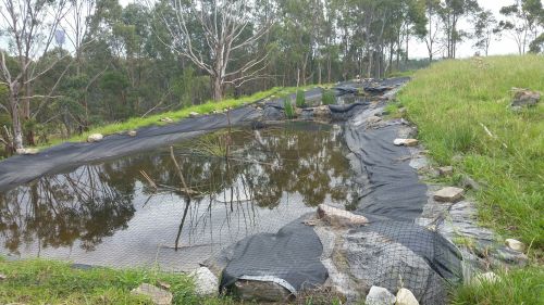
Restoration of the water-holding capacity and connectivity of bell frog habitat in the Brickpit and Kronos Hill has been improved with temporary ponds being created with tarps (Fig 2). The aim is twofold – to extend the number of predator-free, drought refuges, important for adult female frogs and metamorphs and to ensure frog corridors maintain connectivity.  More than 10 tarp ponds have been created and have an expected life span of 3-6 years and are very budget friendly. Annual monitoring has shown a remarkable uptake of these ponds by the Green and Golden Bell Frog.

Figure 2.  Tarp pond with netting

Further results to date. The Parks ecological monitoring program is ongoing and now entering the 16th consecutive year for birds, 15th for reptiles and 21 years for the Green and Golden Bell Frog. In 2018-19 the fourth woodland bird survey was completed, a four yearly assessment of the status of woodland birds and vegetation management at Sydney Olympic Park. Fifteen quadrats are surveyed over the spring and autumn seasons to measure bird communities which is then compared to change in vegetation structure. Results show that small birds were strongly, positively correlated with shrub cover, but strongly negatively correlated with tree cover and Noisy Miner (Manorina melanocephala).  Since 2006, Sydney Olympic Park Authority has implemented a habitat modification program aimed at increasing the structural diversity and complexity of key areas of the Park to support woodland birds. The program seeks to build connectivity between key woodland bird habitats with the form of habitat enhancement varying depending on site characteristics. The survey shows that this program is successfully creating suitable habitat for this group of birds.

With the prospect of greater demands by the public to access the Park at all hours (see below), Sydney Olympic Park staff have recently collected baseline light level readings from across the Park to inform decision making.  Data on lux levels and light source was collected from over 160 sites ranging from car parks to mangrove creeks. The main drive of the survey was to collect information on light spill into sensitive habitat areas where darkness is a key ecological feature. The survey led to a review of lighting and identification of where lights could be switched off or timed to decrease light impacts. The findings will also inform future planning for illumination within the Park.

Lessons learned and future directions. Sydney Olympic Park is part of a rapidly densifying area with the 30,000 residents currently located within a 3km radius forecast to increase to approximately 100,000 in ten years. Due to the density of housing, Sydney Olympic Park will be/is already the local park for this community, leading to increasing demand for recreation and access to the Parklands. This presents great opportunities for more people to connect with nature and to incorporate community education and sustainability into Park programs.  A new program known as Park Care has been launched recently and currently rolls out community clean up and revegetation activities.

The flipside of this rapid population increase is increasing risk of disturbance to ecologically sensitive areas which needs to be considered and mitigated carefully as the Park continues to evolve. Ensuring the Park is able to sustainably meet this demand is a focus for management now and into the future. New habitat management plans for ecologically sensitive areas of the Park are being developed to better-guide biodiversity conservation on a precinct level. Ongoing ecological management works, and managing the impacts of human disturbance, will be essential to conserving the ecological values of the Park.

Contact. Jennifer O’Meara, Parklands Ecologist, Sydney Olympic Park Authority, 5 Olympic Boulevard, Sydney Olympic Park 2127 NSW, Australia. Email: Jenny.omeara@sopa.nsw.gov.au

Restoring the banks of the Namoi on Kilmarnock – UPDATE of EMR feature

Robyn R. Watson

[Update of EMR feature – Watson R. (2009) Restoring the banks of the Namoi on ‘Kilmarnock’: Success arising from persistence. Ecological Management & Restoration,  10: 1 pp 10-19 https://onlinelibrary.wiley.com/doi/10.1111/j.1442-8903.2009.00434.x]

Figure 1. Casuarina (Casuarina cunninghamiana), River Red Gum and a range of grasses established on river bank at Kilmarnock after restoration works. (Photo R. Watson)

Riverbank restoration began on Kilmarnock in early 1990 with fencing the river area and planting native trees, shrubs and grasses. A program of killing the weeping willows resulted in their elimination by 2000. Tree lines were planted to connect the river corridor to natural conservation areas around the farm and this has resulted in a gradual increase in native wildlife leading to great environmental benefits both for the farm and surrounding areas.

Prior to the works the riparian zones on Kilmarnock had degraded to the extent that the banks were slumping during floods, with loss of old trees. This had arisen from decades of clearing, grazing and weed invasion.  Since 2009 we can report that the fenced-off river corridor has continued to recover with native grasses  beneath the trees, particularly Phragmites (Phragmites australis)  and Vetiver Grass (Chrysopogon zizaniodes) which are growing well on the steep river banks (Fig 1).  As the trees in the riparian corridor grew, additional tree lines were planted throughout the farm to connect the riparian zone to retained native vegetation areas and other set-aside conservation areas. This has led to an increase in native birds, micro bats and beneficial insect numbers.

Wildlife have returned to the area, including Little Pied Cormorant (Microcarbo melanoleucos) and  Pied Cormorant (Phalacrocorax varius) nesting in the River Red Gum (Eucalyptus camaldulensis) trees one year. Flocks of Budgerigar (Melopsittacus undulatus) and Spotted Pardalote (Pardalotus punctatus)  have been observed in the trees along the riparian zones.  Pink Eared Duck (Malacorhynchus membranaceus), Musk Duck (Biziura lobata)(, Eurasian Coot (Fulica atra) and Brolga (Antigone rubicunda) visited wetland areas on the farm. There has been a noticeable increase in the small birds such as three different wrens including Superb Fairy-wren (Malurus cyaneus) and Variegated Fairy-wren (Malurus lamberti) and Australasian Pipit (Anthus novaeseelandiae).

The planted irrigated cotton crop was not sprayed with insecticide for 12 years after the increase in beneficial insect and bird numbers. Nest boxes have been installed in the conservation areas for the micro bats.  Fourteen species of insectivorous micro bats have been recorded on the farm since the rehabilitation work began. Stubble quail (Coturnix pectoralis) have been nesting in the conservation areas.

Figure 2. Log groins with planted native trees established on steep river bend near Boggabri through the Namoi Demonstration Reach Project (2007-14) coordinated by the NSW Dept of Primary Industries. (Photo R. Watson)

Further works undertaken nearby.  After seeing the improvement on our farm some adjoining landholders have begun fencing off their river areas and introducing rehabilitation measures on their farms. In one outstanding collective example, 120 kilometres of the Namoi Demonstration Reach Project was established by the NSW Dept of Primary Industries both upstream and downstream of Kilmarnock, from 2007 to 2014.  This This involved contractors, working with permission of a number of landholders, planting over eight thousand trees and shrubs along the river and constructing log groins at a badly eroding river bend near the Boggabri township.  These groins have worked well and have withstood a couple of small floods.  The trees planted on the steep banks have also established well (Fig. 2).


Figure 3. – Planted Phragmites saved the river bank from bush fire in 2017. (Photo R. Watson)

A major bushfire in 2017 spread across the river to the top of the banks on the Kilmarnock side of the river.  Because of the planted Phragmites on the river edge there was no damage done to the toe of the river bank (Fig 3) and we were able to bulldoze firebreaks to protect  the planted trees affected from the fire.)  However, a number of the old River Red Gums were badly burnt. Many of the very old hollow trees were killed by the fire but less hollow ones have begun to grow again, although this growth has been slowed by the present drought.

With the 2019 drought conditions the Namoi River has dried out, exposing the river bed.  This has given me a chance to observe the river bed.  I have been able to photograph and document the debris on the sand banks and the remaining water holes and show that there are now substantial amounts of hollow logs and debris (Fig. 4)  which can  provide good habitat for fish and water creatures when the stream is flowing.

Our family has purchased more land downstream on the Namoi River and we have implemented rehabilitation on the river banks, tree planting and conservation measures on those farms.

Contact.  Robyn Watson, Kilmarnock, Boggabri, NSW 2382, Australia; Tel: 02 67434576 Email: wjwatson@northnet.com.au

Figure 4. Hollow log and debris on riverbed provide fish habitat when river is flowing. (Photo R. Watson)


Recovering Murray-Darling Basin fishes by revitalizing a Native Fish Strategy – UPDATE of EMR feature

John Koehn, Mark Lintermans and Craig Copeland

[Update of EMR Feature: Koehn JD, Lintermans M, Copeland C (2014) Laying the foundations for fish recovery: The first 10 years of the Native Fish Strategy for the Murray‐Darling Basin, Australia. Ecological Management & Restoration, 15:S1, 3-12. https://onlinelibrary.wiley.com/doi/10.1111/emr.12090]

Key words restoration, native fish populations, threatened species, Australia, Murray-Darling Basin

Figure 1. The construction of fishways can help restore river connectivity by allowing fish movements past instream barriers. (Photo: ARI.)

 Introduction. Fish populations in the Murray-Darling Basin (MDB), Australia, have suffered substantial declines due to a wide range of threats and there is considerable concern for their future. Given these declines and the high ecological, economic, social and cultural values of fish to the Australian community, there is a need to recover these populations. In 2003, a Native Fish Strategy (NFS) was developed to address key threats; taking a coordinated, long-term, multi-jurisdictional approach, focussed on recovering all native fish (not just angling species) and managing alien species. The strategy objective was to improve populations from their estimated 10% of pre-European settlement levels, to 60% after 50 years of implementation.

To achieve this the NFS was intended to be managed as a series of 10-year plans to assist management actions in four key areas; the generation of new knowledge, demonstration that multiple actions could achieve improvements to native fish populations, building of a collaborative approach, and the communication of existing as well as newly-acquired science. The NFS successfully delivered more than 100 research projects across six ‘Driving Actions’ in its first 10 years, with highlights including the implementation of the ‘Sea to Hume’ fishway program (restoring fish passage to >2 200 km of the Murray River, Fig 1), improved knowledge of fish responses to environmental water allocations, development of new technologies for controlling alien fish, methods to distinguish hatchery from wild-bred fish, creating a community partnership approach to ‘ownership’ of the NFS, and rehabilitating fish habitats using multiple interventions at selected river (demonstrations) reaches.  The NFS partnership involving researchers, managers, policy makers and the community delivered an applied research program that was rapidly incorporated into on-the-ground management activities (e.g. design of fishways; alien fish control, environmental watering; emergency drought interventions). The NFS largely coincided with the Millennium Drought (1997-2010) followed by extensive flooding and blackwater events, and its activities contributed significantly to persistence of native fish populations during this time.

Funding for the NFS program ceased in 2012-13, after only the first decade of implementation but the relationships among fishers, indigenous people and government agencies have continued along with a legacy of knowledge, development of new projects and collaborative networks with key lessons for improved management of native fishes (see http://www.finterest.com.au/).

Figure 2. Recreational fishers are a key stakeholder in the Murray-Darling Basin, with a keen desire to have sustainable fishing for future generations. (Photo: Josh Waddell.)

Further works undertaken. Whilst the NFS is no longer funded as an official project, many activities have continued though a range of subsequent projects; some are highlighted below:

  • Environmental water: development of fish objectives and implementation of the Basin Plan, northern MDB complementary measures, further investigation of mitigation measures for fish extraction via pumps and water diversions.
  • Fishways: Completion of sea to Lake Hume fishway program and other fishways such as Brewarrina
  • Community engagement: Continuation of many Demonstration (recovery) reaches and intermittent NFS Forums (Fig 2).
  • Recreational fishery management: engagement of anglers through the creation of the Murray Cod (Maccullochella peelii) fishery management group and OzFish Unlimited.
  • Threatened species recovery: success with Trout Cod (Maccullochella macquariensis)  (Fig 3) and Macquarie Perch (Macquaria australasica) populations, development of population models for nine MDB native fish species.
  • Knowledge improvement: research has continued, as has the publication of previous NFS research-related work.
  • Indigenous and community connection to fishes: development of the concept of Cultural flows, involvement in Basin watering discussions.

Figure 3. Trout Cod are a success story in the recovery of Australian threatened species. (Photo: ARI.)

Further results to date. The continued poor state of native fishes means there is a clear need for the continuation of successful elements of the NFS. There is need, however, for revision to provide a contemporary context, as some major changes have occurred over the past decade. The most dramatic of these, at least publicly, has been the occurrence of repeated, large fish kills (Fig 4). This was most evident in the lower Darling River in early 2019 when millions of fish died. The media coverage and public outcry followed the South Australian Royal Commission and two ABC 4Corners investigations into water management, highlighted that all was not well in the Murray-Darling Basin. Indeed, following two inquiries, political recommendations were made to develop a Native Fish Recovery Management Strategy (NFMRS), and a business case is currently being developed. The drought, water extraction and insufficient management efforts to support native fish populations, especially within a broader sphere of a ‘new’ climate cycle of more droughts and climatic extremes, have contributed to these fish kill events. For example, one of the necessary restoration efforts intended from the Basin Plan was to provide more water for environmental purposes to improve river condition and fish populations. Recent research, however, appears to indicate that flow volumes down the Darling River have generally decreased. There is also a continuing decline of species with examples such as Yarra Pygmy Perch (Nannoperca obscura), now being extinct in MDB, and the closely related Southern Pygmy Perch (Nannoperca australis) which is still declining. Monitoring of fish populations has indicated that they remain in poor health and the need for recovery may be even greater than in 2003. We need to act now.

While some of the legacy of the NFS has continued, there has been a loss of integrated and coordinated recovery actions that were a key feature of the NFS. This loss of a Basin-wide approach has resulted in some areas (e.g. small streams and upland reaches) being neglected, with a concentration on lowland, regulated river reaches. There has also been a shift from a multi-threat, multi-solution approach to recovery, to a narrower, flow-focussed approach under the Basin Plan. In addition, there has been the installation of infrastructure (known as Sustainable Diversion Measures) to ‘save’ water which may have deleterious impacts on fish populations (e.g. the impoundment of water on floodplains by regulators or the changed operations of Menindee Lakes on the Darling River).

A clear success of the NFS was improvements in community understanding of native fishes and their engagement in restoration activities. These community voices- indigenous, conservation, anglers, etc. have been somewhat neglected in the delivery of the Basin Plan. There has been ongoing fish researcher and stakeholder engagement, but this has been largely driven by enormous goodwill and commitment from individuals involved in the collaborative networks established through the NFS. While these efforts have been supported by many funding bodies and partners such as the Murray-Darlin Basin Authority, state and Commonwealth water holders and agencies and catchment management authorities, without true cross-basin agreement and collaboration the effectiveness of these efforts will be significantly reduced.

Figure 4. Fish kills have created great public concern and are an indication of the need for improved management of native fish populations. (Photo:Graeme McRabb.)

Lessons learned and future directions.  Native fish populations in the MDB remain in a poor state and improvements will not be achieved without continued and concerted recovery efforts. Moreover, a 5-year review of the NFS indicated that while the actions undertaken to that time had been positive, they needed to be a scaling up considerably to achieve the established goals.  Recovery actions must be supported by knowledge and the lessons learnt from previous experience.  Some fish management and research activities have continued under the auspices of the Basin Plan, but these have largely focussed on the delivery of environmental water, either through water buy-backs or improved efficiency of water delivery. A key requirement is therefore transparent and accurate measurement and reporting of how much flow has been returned to the environment, and how this may have improved fish populations. This remains problematic as evidenced by the recent inquiries into fish kills in the lower Darling River (and elsewhere) and the lack of available water accounting. Fish kills are likely to continue to reoccur and the lingering dry conditions across much of the Northern Basin in 2018-19 and climate forecasts have highlighted the need for further, urgent actions through an updated NFS.

The NFS governance frameworks at the project level were excellent and while some relationships have endured informally, there is a need for an overarching strategy and coordination of efforts across jurisdictions to achieve the improved fish outcomes that are required. The absence of the formal NFS thematic taskforces (fish passage, alien fishes, community stakeholder, demonstration reaches etc) and the absence of any overarching NFS structures means that coordination and communication is lacking, with a focus only on water, limiting the previously holistic, cross jurisdiction, whole-of-Basin approach. The priority actions developed and agreed to for the NFS remain largely relevant, just need revitalized and given the dire status of native fish, scaled up significantly.

Stakeholders and funding. The continuation of quality research and increased understanding of fish ecology, however, not have kept pace with the needs of managers in the highly dynamic area of environmental watering. The transfer of knowledge to managers and the community needs to be reinvigorated. Efforts to engage recreational fishers and communities to become stakeholders in river health are improving (e.g. OzFish Unlimited: https://ozfish.org.au; Finterest website: http://www.finterest.com.au/) but with dedicated, increased support, a much greater level of engagement would be expected.  Previously, the community stakeholder taskforce and Native Fish coordinators in each state provided assistance and direction, including coordination of the annual Native Fish Awareness week. Some other key interventions such as the Basin Pest Fish Plan have not been completed and recovery of threatened fishes have received little attention (e.g. no priority fish identified in the national threatened species strategy).  Funding for fish recovery is now piecemeal, inadequate and uncoordinated, despite the growing need. The $13 B being spent on implementation of the Basin Plan should be complemented by an appropriate amount spent on other measures to ensure the recovery of MDB fishes.

Contact information. John Koehn is a Principal Research Scientist at the Arthur Rylah Institute for Environmental Research, Department of Environment, Land, Water and Planning, was an author the Murray-Darling Basin Native Fish Strategy and a member of various Native Fish Strategy panels and projects (Email:  John.Koehn@delwp.vic.gov.au). Mark Lintermans is an Associate Professor at Institute for Applied Ecology, University of Canberra, and was a member of various Native Fish Strategy panels and projects; (Email: Mark.Lintermans@canberra.edu.au). Craig Copeland is the CEO of OzFish Unlimited and a leading contributor to the development of the next stage of the Native Fish Strategy, the Northern Basin Complementary Measures Program and the 2017 MDB Native Fish Forum (Email: craigcopeland@ozfish.org.au).


Recovery of indigenous plants and animals in revegetated areas at ‘The Waterways’, Victoria.

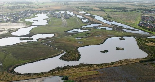
Photo 1.  Aerial view of Waterways from the west

By Damien Cook

 Introduction. Waterways is a 48-hectare restoration project located on Mordialloc Creek in Melbourne’s south- eastern suburbs which combines a housing estate with large areas of restored habitat set aside for indigenous fauna and flora in open space, lakes and other wetlands (see Photo 1).

Prior to restoration the land at Waterways was a property used for grazing horses and supported pasture dominated by exotic species such as Reed Fescue (*Festuca arundinacea) and Toowoomba Canary Grass (*Phalaris aquatica). (Note that an Asterix preceding a scientific name denotes that the species is not indigenous to the local area).

The habitats which are being restored at “The Waterways” reflect those that originally occurred in the Carrum Carrum Swamp, a vast wetland complex which, prior to being extensively drained in the 1870s, stretched from Mordialloc to Kananook and as far inland as Keysborough.

Local reference ecosystems were selected to act as a benchmark for what was to be achieved in each restored habitat in terms of species diversity and cover. Habitat Hectare assessments have been used to monitor the quality of restored vegetation (see Appendix 1).

A total of nine Ecological Vegetation Classes (EVCs, the standard unit of vegetation mapping in Victoria) are being re-established across the site across the following habitats

  • Open water, Submerged Aquatic Herbfields and Exposed Mudflats
  • Densely vegetated marshes
  • Swamp Paperbark Shrubland
  • Tussock Grassland
  • Plains Grassy Woodland

Photo 2. This sequence of photographs, taken over a nine-month period at the Waterways, shows vegetation establishment in a constructed wetland from newly constructed and bare of native species on the left to well vegetated with a high cover of indigenous plants and minimal weeds on the right.

Works undertaken. Restoration of the site commenced in October 2000. Extensive weed control and earthworks were carried out prior to the commencement of revegetation works, which involved planting, by 2003, over 2 million local provenance, indigenous plants.  Grassland species were planted out of hikos at a density of 5 to 6 per square meter into areas that had been treated with both knock-down and pre-emergent herbicide. Ongoing management of the site has included ecological burning and follow up weed control. When started the Waterways was the largest and most complex ecological restoration project ever undertaken in Victoria.

Results

Plants

Open water, Submerged Aquatic Herbfields and Exposed Mudflats.  Deep, open water areas cover an area of about 30 hectares of the site. Vegetation growing in this habitat includes submerged herb-fields of Pondweeds (Potamogeton species), Eel Grass (Vallisneria australis) and Stoneworts (Chara and Nitella species), which were planted over summer 2000/01.

Densely vegetated marshes. This habitat occupies about 10 hectares of the site, occurring where water is less than 1.5 meters deep around the fringes of the lakes and as broad bands across the wetlands. Swards of large sedges including Tall Spike-rush (Eleocharis sphacelata), Jointed Twig-sedge (Baumea articulata), Leafy Twig-sedge (Cladium procerum) and River Club-rush (Schoenoplectus tabernaemontani); aquatic herb-fields of Water Ribbons (Cycnogeton procerum), Upright Water-milfoil (Myriophyllum crispatum) and Running Marsh-flower (Ornduffia reniformis); as well as meadows supporting rushes, sedges and amphibious herbs. Localized areas with high salinity (4000 to 12 000 ppm) have been planted with a halophytic (salt tolerant) community including Sea Rush (Juncus krausii), Australian Salt-grass (Distichlis distichophylla), and Shiny Swamp-mat (Selliera radicans). Planting began in the marshes at the Waterways in October 2000 and vegetation established very rapidly in most areas (see Photo 2). This vegetation type provides habitat for the locally vulnerable Woolly Water-lily (Philydrum lanuginosum).

Swamp Paperbark Shrubland covers about 8 hectares, consisting of a 1ha remnant and additional areas that were planted in spring/summer 2001. As this shrubland habitat matures it is forming a dense canopy of species including Swamp Paperbark (Melaleuca ericifolia), Prickly Moses (Acacia verticillata subsp. verticillata), Manuka (Leptospermum scoparium), Woolly Tea-tree (Leptospermum lanigerum), Tree Everlasting (Ozothamnus ferrugineus) and Golden Spray (Viminerea juncea).

Photo 3. Rare plant species that have been established in restored native grasslands at “Waterways” include Grey Billy-buttons (Craspedia canens), Matted Flax-lily (Dianella amoena) and Pale Swamp Everlasting (Coronidium gunnianum).

Tussock Grassland covers about four hectares at the Waterways between two major wetland areas. About a third of this habitat was planted in spring 2001, with the remainder in spring 2002. The dominant plants of this habitat are tussock-forming grasses including wallaby grasses (Rytidosperma species), Kangaroo Grass (Themeda triandra) and Common Tussock Grass (Poa labillardierei var. labillardierei). A diverse array of native wildflowers occurs amongst these grasses. Rare plant species that have been established in this habitat zone include Grey Billy-buttons (Craspedia canens), Matted Flax-lily (Dianella amoena) and Pale Swamp Everlasting (Coronidium gunnianum, see Photo 3).

Plains Grassy Woodland This habitat type occurs in mosaic with Tussock grassland and differs in that it supportsscattered trees and clumps of shrubs. River Red Gum (Eucalyptus camaldulensis subsp. camaldulensis) and Swamp Gum (Eucalyptus ovata var. ovata) have been planted so that they will eventually form an open woodland structure. Other tree and tall shrub species planted in this habitat include Drooping Sheoak (Allocasuarina verticillata), Blackwood (Acacia melanoxylon) and the tree form of Silver Banksia (Banksia marginata), which is now very uncommon in the local area.

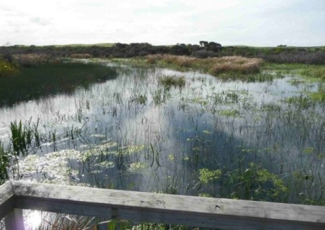
Seasonal Wetlands Small seasonal wetlands occur within Tussock Grassland (see Photo 4). Rare plant species that have been established in this habitat zone include Swamp Billy-buttons (Craspedia paludicola), Woolly Water-lily (Philydrum lanuginosum), Grey Spike-rush (Eleocharis macbarronii), Giant River Buttercup (Ranunculus amplus) and the nationally endangered Swamp Everlasting (Xerochrysum palustre).


Photo 4. Seasonal rain-filled wetland at Waterways

 Animals.

The Waterways is home to 19 rare and threatened fauna species including the nationally endangered Australasian Bittern (Botaurus poiciloptilus), Glossy Grass Skink (Pseudemoia rawlinsoni) and Magpie Goose (Anseranas semipalmata). The successful establishment of diverse vegetation has so far attracted 102 species of native birds, and the wetlands on the site are home to seven species of frogs.

Open water areas support large populations of Black Swans (Cygnus atratus), Ducks (Anas species), Eurasian Coots (Fulica atra), Cormorants (Phalacrocorax and Microcarbo species), Australian Pelicans (Pelecanus conspicillatus) and Australasian Darters (Anhinga novaehollandiae) that either feed on fish and invertebrates or the foliage and fruits of water plants.  As water levels recede over summer areas of mudflat are exposed. These flats provide ideal resting areas for water birds as well as feeding habitat for migratory wading birds including the Sharp-tailed Sandpiper (Calidris acuminata), Red-necked Stint (Calidris ruficollis) and Common Greenshank (Tringa nebularia) that fly from their breeding grounds as far away as Alaska and Siberia to spend the summer in Australia and are protected under special treaties between the Governments of countries through which they travel.

Photo 5. Magpie Geese (Anseranas semipalmata) at Waterways

In 2007 a small group of Magpie Geese (Anseranas semipalmata) became regular visitors to The Waterways (see Photo 5). This species was once extremely abundant in the Carrum Carrum Swamp. However, it was driven to extinction in southern Australia in the early 1900s by hunting and habitat destruction. The Magpie Goose seems to be making a recovery in Victoria, with numbers building up from birds captured in the Northern Territory and released in South Australia that are spreading across to areas where the species formerly occurred.

Seasonal wetlands are important breeding areas for frogs including the Banjo Frog (Limnodynastes dumerilii), Striped Marsh Frog (Limnodynastes peroni) and Spotted Grass Frog (Limnodynastes tasmaniensis) and a range of invertebrates that do not occur in the larger, more permanent storm water treatment wetlands such as Shield Shrimp (Lepidurus apus viridus). Birds which utilize these wetlands for feeding include the White-faced Heron (Egretta novaehollandiae) and Latham’s Snipe (Gallinago hardwickii).

Restored grassland provides an ideal hunting ground for several birds of prey, including the Brown Falcon (Falco berigora), Black-shouldered Kite (Elanus axillaris) and Australian Kestrel (Falco cenchroides). It also provides cover and feeding habitat for insect and seed-eating birds such as the Brown Quail (Coturnix ypsilophora). A flock of about 20 Blue-winged Parrots (Neophema chrysostoma) have been regularly seen in this habitat. These parrots are usually quite uncommon in the Melbourne area. Moist grasslands beside the wetland have been colonised by the vulnerable Glossy Grass Skink (Pseudemoia rawlinsoni) (see Photo 6).

Densely vegetated marshes provide habitat for a diversity of small, secretive birds such as Ballion’s Crake (Porzana pusilla), Little Grassbird (Megalurus gramineus) and Australian Reed Warbler (Acrocephalus australis), which find suitable refuges in the cover provided by dense vegetation. Dense thickets of Swamp Paperbark shrublands provide cover and feeding habitat for Ring-tail Possums (Pseudocheris peregrinus) and bushland birds such the Eastern Yellow Robin (Eopsaltria australis), thornbills (Acanthiza species), Superb Fairy-wren (Malurus cyaneus) and Grey Fantail (Rhipidura albiscapa). As the grassy woodlands mature they are providing structural habitat diversity and accommodating woodland birds such as cuckoos (Cacomantis and Chalcites species) and pardalotes (Pardalotus species).

It will take many years for the River Red Gums to reach a majestic size and stature, and to provide tree hollows which are essential for many species of native fauna. A limited number of tree hollows are provided in the dead trees (stags) that were placed in the Waterways wetlands.

Photo 6. The vulnerable Glossy Grass Skink (Pseudemoia rawlinsoni) at Waterways

The Future. The habitats that have been created at the Waterways are about 18 years old, yet they have already attracted a vast array of native fauna. Waterways is now home to 14 rare and threatened plant species and 19 threatened animal species. There is incredible potential for the area to provide vitally important habitat for an even greater diversity of rare plants and animals as these habitats mature.

If the area is to reach its full potential careful management of weeds and pest animals is required. Ongoing monitoring of flora and fauna is also necessary. These are both areas in which the local community is becoming involved.

Acknowledgements. The high standard of restoration achieved on the Waterways project was due to the project being appropriately funded and because it was managed by ecologists experienced in planning and implementing ecological restoration.  The project was partly funded by Melbourne Water, who are now the managers of the site, and partly by a developer, the Haines Family.  This unique relationship and the generosity and willingness to try something innovative by the developer were important factors in the success of the project.

Contact: Damien Cook (rakali2@outlook.com.au)

Appendix 1. Habitat Hectare results for four quadrats at Waterways, 2006

Landscape-scale terrestrial revegetation around the Coorong, Lower Lakes and Murray Mouth, South Australia

Hafiz Stewart, Ross Meffin, Sacha Jellinek

Key words. Restoration, prioritisation, woodland, ecosystems

Introduction. Located in South Australia at the terminus of the Murray-Darling River, the Coorong, Lower Lakes and Murray Mouth (CLLMM) region has immense ecological, economic and cultural importance. The landscape varies from the low hills of Mount Lofty Ranges in the northwest, through the low valleys and plains surrounding Lake Alexandrina and Lake Albert, to the plains and dunes of the Coorong in the southeast (Fig 1). These landforms had a large influence on the composition of pre-European vegetation communities in the region, with the Mount Lofty Ranges dominated by eucalypt forests and woodlands, the lakes surrounded by a mixture of mallee, temperate shrublands and wetland vegetation, and the Coorong supporting coastal and wetland vegetation communities.

The region has been extensively cleared since European settlement and the introduction of intensive agriculture (cropping and grazing), so that now only a fraction of the original native vegetation remains. This has resulted in a substantial decline in biodiversity and recognition of the area as a critically endangered eco-region. These impacts have been compounded by water extraction upstream and anthropogenic changes to hydrological regimes. The recent drought further exacerbated these environmental problems and severely affected the region’s people and economy.

Fig. 1. The Coorong, Lower Lakes and Murray Mouth region showing terrestrial and aquatic plantings.

Figure 1. The Coorong, Lower Lakes and Murray Mouth region showing terrestrial and aquatic plantings.

Broad aim and any specific objectives. In response to drought and other issues affecting the region the Australian and South Australian governments funded the landscape-scale CLLMM Recovery Project (2011 – 2016). This project aims to help restore the ecological character of the site and build resilience in the region’s ecosystems and communities. As a part of this, the CLLMM Vegetation Program aimed to strategically restore native vegetation to buffer and increase the connectivity of existing remnants.

Works undertaken. Three key tools were utilised to achieve these goals. First, an integrated Landscape Assessment was used to identify priority plant communities for restoration in the region. To do this, we classified vegetation types occurring in the CLLMM landscape, then identified suites of bird species associated with each vegetation type. The status and trends of each of these bird species were then used as indicators to determine the conservation priority of each vegetation type. Second, a framework was developed to identify the most appropriate vegetation types to reconstruct at a given site, depending on characteristics such as soil type and landform. This was based on the composition and structure of remnant communities and their associated environmental settings. Finally, a Marxan analysis was conducted across the region to prioritise sites for restoration works based on the aims of the program, with an aspirational target of restoring 30% of each priority vegetation type. Following an expression of interest process that made use of existing networks in the local community and the traditional owners of the CLLMM and surrounding area, the Ngarrindjeri, prioritised sites were then selected from those made available by landholders.

For each site, we developed a plan specifying the site preparation required, and species and densities to be planted. Native plants were sourced from local nurseries, ensuring that provenance and appropriate collection guidelines were followed. Tubestock was used to provide an opportunity for social benefits, including the development of community run nurseries, and due to their higher survival rates. Planting was carried out by regional contractors engaged by the CLLMM Recovery Project Vegetation Program, along with the Goolwa to Wellington Local Action Planning association and the Ngarrindjeri Regional Authority. During this program wetland restoration was also undertaken through the planting of a native sedge species, the River Club Rush (Schoenoplectus tabernaemontani), which assisted in stabilising shorelines and creating habitat for aquatic plant communities.

Results to date. By the end of the program around 5 million native plants will have been planted at 148 sites on private and public land covering more than 1,700 hectares (Fig. 1). In total 202 species of plants have currently been planted, comprising 11% overstorey, 38% midstorey and 51% understorey species. Initial results indicate that around 66% of plants survive the first summer, at which point they are well established. Woodland and mallee bird species are starting to use these revegetated areas. When compared to remnant areas of the same vegetation type, both native plant species richness and bird diversity are lower in restored habitats. However, while the bird communities in restored habitats are dominated by generalist species, specialist species such as endangered Mount Lofty Ranges Southern Emu-Wrens have been recorded in revegetated areas, providing early signs that planted areas are benefiting rarer species. The restored communities are still very young, and over time we expect these areas will start to structurally resemble remnant habitats.

Lessons learned and future directions. Resourcing of research alongside program delivery allowed us to implement a sound prioritisation process and a systematic, strategic, and effective approach to the restoration of the landscape. The capacity to collect good vegetation, soil and bird occurrence data was crucial to this. Successful delivery also required funding for site preparation and follow-up, a well-developed network of native plant nurseries, engaged community and indigenous groups, and good relationships with local landholders.

Stakeholders and Funding bodies. The CLLMM Vegetation Program is a landscape scale habitat restoration project, jointly funded by the Australian and South Australian governments under the Coorong, Lower Lakes and Murray Mouth Recovery Project. We would like to thank the Goolwa to Wellington Local Action Planning Association, the Milang and Districts Community Association and the Ngarrindjeri Regional Authority for their assistance in undertaking this revegetation. DEWNR’s Science, Monitoring and Knowledge branch undertook the initial ecosystem analysis.

Contact information.  Hafiz Stewart, Department of Environment, Water and Natural Resources, South Australia. Hafiz.stewart@sa.gov.au

Restoring wetland communities in the Coorong and Lower Lakes, South Australia

[Summary will be reinstated soon.]

Piccaninnie Ponds Conservation Park, South Australia

Mark Bachmann

Key words: wetland restoration, Ramsar, rising springs, drainage, hydrology

Piccaninnie Ponds Conservation Park is situated 30 km south east of Mt Gambier in South Australia. For 15-20 years after the park was proclaimed in 1969, there was considerable local interest in trying to address previous changes that had been made to the hydrology of the wetland system.

Although it was protected, reserved and supporting a diverse suite of habitats and range of resident threatened species, Piccaninnnie Ponds was far from intact from a hydrological perspective. Prior to European settlement, water that discharged from the karst, rising-spring wetlands in the system flowed eastward across the State border into the Glenelg River Estuary, in far South West Victoria.

This is how the system remained until 1906, when the first of several attempts to drain the wetlands of Piccaninnie Ponds directly to the sea occurred. What ensued was a turbulent 9 year period during which the fishermen successfully lobbied to have the creek re-directed to the Glenelg River in 1915; a step which was ultimately unpopular with affected landholders and resulted in an alternative flow path again being cut to the sea two years later in 1917. Subsequent ad hoc drainage and development of portions of the wetland system continued and by the time the Piccaninnie Ponds Conservatioon Park was proclaimed in 1969, a new main artificial outlet drained the ponds directly to the sea.

The first attempts at advocacy to restore environmental flows to the Glenelg River in the 1970s and 80s to counter this long-term drying trend in the Park were unsuccessful, until the concept was revisited and a series of steps undertaken, starting in 2001, to achieve hydrological restoration. These steps culminated in the following actions.

 Fig. 1 – Stage 1 weir and fishway under construction in 2006.

Fig. 1,  Stage 1 weir and fishway under construction in 2006.

Actions taken to correct hydrology

  1. 2006 – Stage 1 weir and fishway constructed at Piccaninnie Ponds (Figure 1) regulated outflows on the artificial outlet. This had the effect of increasing inundation in a small area immediately upstream of the structure, under the direct influence of the weir pool created by the new structure, as shown in Fig 2.
  2. 2013 – The stage 2 weir and fishway upgrade (Fig 3) resulted in the structure height being lifted to increase future management flexibility, including providing the future ability to completely block outflows, should the option of re-instating the original flow path one day become a reality.

The stage 2 upgrade was completed at the same time as providing a new flow path to physically reconnect the isolated eastern and western basins at Piccaninnie Ponds. These wetlands had been separated for several decades by a combination of lower water levels, sand drift and the impact of the Piccaninnie Ponds Road. An aerial photographic view of the new flow path is shown in Fig 4.

These works within the original Conservation Park, have occurred in in a complementary way with those that have occurred in the neighbouring, newly reserved area at Pick Swamp, each contributing to the wider vision for restoration of this wetland complex.

Fig. 2. Drained condition of habitat in 2006

Fig. 2a. Drained condition of habitat upstream of the Stage 1 weir (prior to construction  in 2006).

Fig. 3. The upstream inundation and habitat change caused by the stage 1 weir, 2012.

Fig. 2b. The upstream inundation and habitat change caused by the stage 1 weir, 2012.

Results to date.

  • Increase in quality and area of available habitat for native freshwater fish, including the nationally threatened Dwarf Galaxias (Galaxiellla pusilla)
  • Protection of hydrological processes that support a wide range of other threatened species, from a number of taxonomic groups
  • A positive trajectory of change in the distribution of wetland habitats in the vicinity of the works (increased aquatic habitat and reversal of a drying trend that was causing terrestrialisation of vegetation communities)
  • Re-establishment of connectivity between the western and eastern wetlands in the Park for the first time in several decades
Figure 4 – The lifted and redesigned stage 2 weir and fishway on the main artificial outlet at Piccaninnie Ponds – upon completion in 2013.

Fig. 3. The lifted and redesigned stage 2 weir and fishway on the main artificial outlet at Piccaninnie Ponds – upon completion in 2013.

Fig 5a. Piccaninnie

Fig. 4a. Before works – in January 2003

Figure 5 – TOP – Before works image: January 2003. BOTTOM – Post-construction/restoration image: January 2014.

Fig, 4b. After construction/restoration – in January 2014.

Future directions. The works and outcomes described here were delivered by staff working for the South Australian Department of Environment, Water and Natural Resources (DEWNR)

  • Ongoing management of the works and associated ecological monitoring in Piccaninnie Ponds Conservation Park is managed by DEWNR
  • Nature Glenelg Trust staff continue to provide specialist ecological advice and monitoring for the site when required by the site manager, DEWNR

Acknowledgements. The outcomes of the restoration project described can be attributed to a wide range of people who, in addition to the author (see current contact details below), worked at the South Australian Department of Environment, Water and Natural Resources during the period described. DEWNR project ecologists overseeing the works described here include Ben Taylor (stage 1 weir) and Steve Clarke (stage 2 weir and associated works).

The project was generously funded and supported by a range of different grants and programs administered by the South Australian Government, Australian Government and the South East Natural Resources Management Board.

Contact. Mark Bachmann. Nature Glenelg Trust, PO Box 2177, Mt Gambier, SA 5290 Australia; Tel +61 (0)8 8797 8181; Mob+61 (0) 421 97 8181; Email: mark.bachmann@natureglenelg.org.au Web| www.natureglenelg.org.au

See also:

Bradys Swamp EMR short summary

Long Swamp EMR short summary

Long Swamp, Discovery Bay Coastal Park, Victoria

Mark Bachmann

Key words: wetland restoration, Ramsar, hydrology, Glenelg River, drainage

Long Swamp is a 15 km long coastal freshwater wetland complex situated in Discovery Bay Coastal Park, approximately 50 km north-west from Portland in south-western Victoria. The wetland system supports a diverse suite of nationally threatened species and is currently undergoing a Ramsar nomination process. Despite its size, reserved status and impressive biodiversity values, including recognition on the Directory of Important Wetlands in Australia, the local community in Nelson had expressed concern for over a decade about the impact that two artificial outlets to the ocean were having on wetland condition. The outlets were cut during an era when the swamp was grazed, many decades before being dedicated as a conservation reserve in the 1970s.

The wetland originally discharged into the ocean via Oxbow Lake and the Glenelg River mouth at Nelson. These changes to hydrology caused an interruption of flows, contributing to a long-term drying trend within the wetland complex.    This was not immediately obvious to many as the gradual drying of wetlands in a natural area is often less noticeable than in a cleared agricultural area, driven by a seamless and gradual shift towards more terrestrial species within the composition of native vegetation (Fig. 1).

Figure 1. Shrub (Leptospermum lanigerum) encroachment into sedgeland underway in Long Swamp.

In 2012, Nature Glenelg Trust (NGT) became actively involved in Long Swamp, working closely with Parks Victoria, the Nelson Coast Care Group, and the Glenelg Hopkins CMA. The initial involvement was to undertake a scientific review of the aquatic ecological values that might be impacted by the ecological shifts anecdotally observed to be underway. This early work identified that the more remote artificial outlet to the sea (White Sands) had in fact naturally closed, with a dune forming in front of the former channel several years earlier during the Millennium Drought (c. 2005). This formed an area of aquatic habitat immediately upstream of the former outlet that is now home to a diverse native freshwater fish community, including two nationally threatened fish species, the Yarra Pygmy Perch (Nannoperca obscura) and Dwarf Galaxias (Galaxiella pusilla). This observation and other investigations led to the planning of a restoration trial aimed at regulating or possibly blocking the second and final artificial outlet at Nobles Rocks to increase the availability, diversity and connectivity of aquatic habitats throughout Long Swamp, in order to benefit a wide range of wetland dependant species.

As well as undertaking basic monitoring across a broad range of taxonomic groups (birds, vegetation, frogs), the project has a particular emphasis on native freshwater fish populations as a primary indicator of project success.

Figure 2 – Aerial view of Nobles Rocks artificial outlet, detailing the location of the three trial sandbag structures.

Figure 2 . Aerial view of Nobles Rocks artificial outlet, detailing the location of the three trial sandbag structures.

Figure 3 - NGT staff members celebrate the completion of the third and final sandbag structure with some of the many dedicated volunteers from the local community.

Figure 3. Nature Glenelg Trust staff members celebrate the completion of the third and final sandbag structure with some of the many dedicated volunteers from the local community.

Reversal of artificial outlet impact over three phases.

The first two stages of the restoration trial in May and July 2014 involved 56 volunteers from the community working together to construct low-level temporary sandbag structures, initially at the most accessible and technically feasible sections of drain under flowing conditions. Tackling the project in stages enabled us to learn sufficient information about the hydrological conditions at the site in 2014, before commencing the third and final stage of the trial in March 2015. On the 27th April 2015, the main structure was completed, following two days of preparation and nine days of sandbagging (using about 6,600 sandbags), which were put in place with the dedicated help of over 30 volunteers (see Figs 3 and 4). To achieve our target operating height, the structure was raised by a further 30 cm in August 2015.

A series of gauge boards with water depth data loggers were also placed at key locations in the outlet channel and upstream into Long Swamp proper, to monitor the change in water levels throughout each stage of restoration and into the future.

Fig 4a. Long swamp

Figure 4a. View of the Phase 3 Restoration Trial Structure location prior to construction in March 2015.

Fig 4b. Long swamp

Figure 4b. Same location in June 2015, after construction of the Restoration Trial Structure.

Results to date.

Water levels in the swamp immediately upstream of the final structure increased, in the deepest portion of Long Swamp, from 34 cm (in April 2015) to 116 cm (in early September 2015). Further upstream, in a shallower area more representative of the impact on Long Swamp in the adjacent wider area, levels increased from being dry in April 2015, 14 cm deep in May, through to 43 cm deep in early September 2015, as shown in Figure 5. This is a zone where the shrub invasion is typical of the drying trend being observed in Long Swamp, and hence will be an important long-term monitoring location.

To evaluate the response of habitat to short and longer-term hydrological change, we also undertook longer-term landscape change analysis through GIS-based interpretation of aerial photography. This showed that we have currently recovered approximately 60 hectares of total surface water at Nobles Rocks, not including larger gains across downstream habitats as a result of groundwater mounding, sub-surface seepage and redirected surface flows that have also been observed.  These initial results and longer-term outcomes for targets species of native plants and animals will be detailed fully in future reports.

Fig 5a. Long swamp

Figure 5a. Further inland in the swamp after the Phase 3 structure was complete, shown here in May 2015. Depth – 14 cm.

Fig 5b. Long swamp

Figure 5b. Same photopoint 4 months later in September 2015. Depth – 43 cm.

Lessons learned and future directions.Meaningful community participation has been one of the most critical ingredients in the success of this project so far, leading to a strong sense of shared achievement for all involved. Monitoring will continue to guide the next steps of the project, with the ultimate aim of informing a consensus view (among those with shared interest in the park) for eventually converting the trial structure to a permanent solution.

Acknowledgements. Project partners include Parks Victoria, Nelson Coast Care Group, the Glenelg Hopkins CMA and the Friends of the Great South West Walk. Volunteers from several other groups have also assisted with the trials. Grant funding was generously provided by the Victorian Government.

Contact. Mark Bachmann, Nature Glenelg Trust, PO Box 2177, MT GAMBIER, SA 5290 Australia, Tel +61 8 8797 8181, Mob 0421 97 8181, Email: mark.bachmann@natureglenelg.org.au  Web: www.natureglenelg.org.au

See also:

Video conference presentation

NGH newsletter – including a link to a video on the project

Bradys Swamp EMR short summary

Picanninnie Ponds EMR short summary


Brady Swamp wetland complex, Grampians National Park, Victoria

Mark Bachmann

Key words: wetland restoration, Wannon River, hydrology, drainage, Gooseneck Swamp

A series of wetlands associated with the floodplain of the Wannon River (Walker, Gooseneck, and Brady Swamps), situated approximately 12 km north east of Dunkeld in western Victoria, were partially drained from the 1950s onwards for grazing purposes (Fig 1). A portion of these wetlands was later acquired and incorporated into the Grampians National Park (and other peripheral reserves) in the mid-1980s, managed by Parks Victoria. However, the balance of the wider wetland and floodplain area remained under private ownership, creating a degree of uncertainty surrounding reinstatement of water regime – an issue that was left unresolved for over two decades.

Many years of planning work, including modelling studies and biological investigations by a range of organisations, never quite managed to adequately resolve the best way to design and progress wetland restoration work in this area. To address the impasse, at the request of the Glenelg Hopkins CMA in early 2013, Nature Glenelg Trust proposed a staged restoration trial process which was subsequently agreed to by landowners, neighbours, government agencies, and local community groups.

Figure 1. Image from the present day: showing artificial drains (red lines/arrows) constructed to drain Walker, Gooseneck and Brady Swamps, as it operated from the 1950s–2013.

Figure 1. Image from the present day: showing artificial drains (red lines/arrows) constructed to drain Walker, Gooseneck and Brady Swamps, as it operated from the 1950s–2013.

Trials and permanent works undertaken.

Initial trials. The restoration process began in August 2013 with the installation of the first trial sandbag weir structure to regulate the artificial drain at Gooseneck Swamp. Its immediate success in reinstating wetland levels led to similar trials being initiated at Brady Swamp and Walker Swamp (Fig. 2) in 2014.

Figure 2. The volunteer sandbagging crew at the artificial drainage outlet from Walker Swamp - August 2014.

Figure 2. The volunteer sandbagging crew at the artificial drainage outlet from Walker Swamp – August 2014.

Permanent works were ultimately undertaken to reinstate the breached natural earthen banks at Brady and Gooseneck Swamps (Figure 3), implemented by Nature Glenelg Trust in early 2015.

Figure 3a. Trial Structure on the Brady Swamp outlet drain in 2014

Figure 3b. The same view shown in Figure 3a, after the completion of permanent works in 2015

Results. The works have permanently reinstated the alternative, original watercourse and floodplain of the Wannon River, which now activates when the water levels in these wetlands reach their natural sill level. This is predicted to have a positive impact on a wide range of flora and fauna species.

Monitoring is in place to measure changes to vegetation and the distribution and status of key fauna species, such as waterbirds, fish and frogs. Due to drought conditions experienced in 2015, to is too early to describe the full ecological impact of the works at this time.

4. Gooseneck Swamp in Sept 2014: the second season of the restoration trial, just prior to the implementation of permanent restoration works

Figure 4. Gooseneck Swamp in Sept 2014: the second season of the restoration trial, just prior to the implementation of permanent restoration works

Lessons learned. The success of these trials has been based on their tangible ability to demonstrate, to all parties involved, the potential wetland restoration outcome for the sites; made possible by using simple, low-cost, impermanent methods. To ensure the integrity of the trial structures, the sandbags used for this purpose are made of geotextile fabric, with a minimum field service life of approximately 5 years.

The trials were critical for building community confidence and collecting real operational data for informing the development of longer-term measures to increase the depth and duration of inundation.

A vital aspect of the trials has been the level of community participation, not only at the sandbagging “events”, but also the subsequent commitment to ecological monitoring, for helping evaluate the biological impacts of hydrological reinstatement. For example, the Hamilton Field Naturalists Club has been undertaking monthly bird monitoring counts that are helping Nature Glenelg Trust to develop a picture of the ecological value of these wetlands and their role in the wider landscape, including the detection of international migratory species.

Acknowledgements. Project partners include Parks Victoria, Hamilton Field Naturalists Club, the Glenelg Hopkins CMA, Macquarie Forestry and other private landholders. Volunteers from several other groups have also assisted with the trials. Grant funding was generously provided by the Victorian Government.

Contact. Mark Bachmann, Nature Glenelg Trust, PO Box 2177, MT GAMBIER, SA 5290 Australia. Tel +61 8 8797 8181, Mob 0421 97 8181; Email mark.bachmann@natureglenelg.org.au. Web| www.natureglenelg.org.au

See also:

Long Swamp EMR short summary

Picanninnie Ponds EMR short summary