Category Archives: Standards

Recovery of indigenous plants and animals in revegetated areas at ‘The Waterways’, Victoria.

Photo 1.  Aerial view of Waterways from the west

By Damien Cook

 Introduction. Waterways is a 48-hectare restoration project located on Mordialloc Creek in Melbourne’s south- eastern suburbs which combines a housing estate with large areas of restored habitat set aside for indigenous fauna and flora in open space, lakes and other wetlands (see Photo 1).

Prior to restoration the land at Waterways was a property used for grazing horses and supported pasture dominated by exotic species such as Reed Fescue (*Festuca arundinacea) and Toowoomba Canary Grass (*Phalaris aquatica). (Note that an Asterix preceding a scientific name denotes that the species is not indigenous to the local area).

The habitats which are being restored at “The Waterways” reflect those that originally occurred in the Carrum Carrum Swamp, a vast wetland complex which, prior to being extensively drained in the 1870s, stretched from Mordialloc to Kananook and as far inland as Keysborough.

Local reference ecosystems were selected to act as a benchmark for what was to be achieved in each restored habitat in terms of species diversity and cover. Habitat Hectare assessments have been used to monitor the quality of restored vegetation (see Appendix 1).

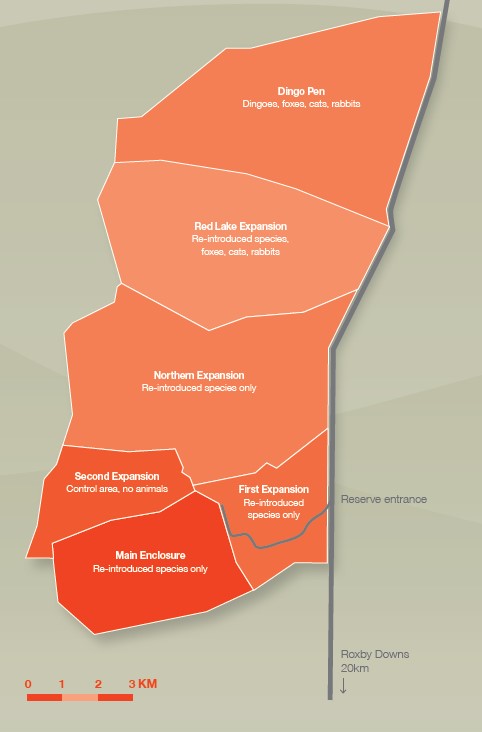
A total of nine Ecological Vegetation Classes (EVCs, the standard unit of vegetation mapping in Victoria) are being re-established across the site across the following habitats

  • Open water, Submerged Aquatic Herbfields and Exposed Mudflats
  • Densely vegetated marshes
  • Swamp Paperbark Shrubland
  • Tussock Grassland
  • Plains Grassy Woodland

Photo 2. This sequence of photographs, taken over a nine-month period at the Waterways, shows vegetation establishment in a constructed wetland from newly constructed and bare of native species on the left to well vegetated with a high cover of indigenous plants and minimal weeds on the right.

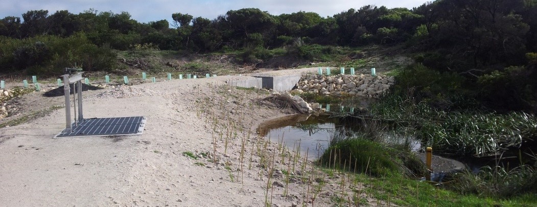
Works undertaken. Restoration of the site commenced in October 2000. Extensive weed control and earthworks were carried out prior to the commencement of revegetation works, which involved planting, by 2003, over 2 million local provenance, indigenous plants.  Grassland species were planted out of hikos at a density of 5 to 6 per square meter into areas that had been treated with both knock-down and pre-emergent herbicide. Ongoing management of the site has included ecological burning and follow up weed control. When started the Waterways was the largest and most complex ecological restoration project ever undertaken in Victoria.

Results

Plants

Open water, Submerged Aquatic Herbfields and Exposed Mudflats.  Deep, open water areas cover an area of about 30 hectares of the site. Vegetation growing in this habitat includes submerged herb-fields of Pondweeds (Potamogeton species), Eel Grass (Vallisneria australis) and Stoneworts (Chara and Nitella species), which were planted over summer 2000/01.

Densely vegetated marshes. This habitat occupies about 10 hectares of the site, occurring where water is less than 1.5 meters deep around the fringes of the lakes and as broad bands across the wetlands. Swards of large sedges including Tall Spike-rush (Eleocharis sphacelata), Jointed Twig-sedge (Baumea articulata), Leafy Twig-sedge (Cladium procerum) and River Club-rush (Schoenoplectus tabernaemontani); aquatic herb-fields of Water Ribbons (Cycnogeton procerum), Upright Water-milfoil (Myriophyllum crispatum) and Running Marsh-flower (Ornduffia reniformis); as well as meadows supporting rushes, sedges and amphibious herbs. Localized areas with high salinity (4000 to 12 000 ppm) have been planted with a halophytic (salt tolerant) community including Sea Rush (Juncus krausii), Australian Salt-grass (Distichlis distichophylla), and Shiny Swamp-mat (Selliera radicans). Planting began in the marshes at the Waterways in October 2000 and vegetation established very rapidly in most areas (see Photo 2). This vegetation type provides habitat for the locally vulnerable Woolly Water-lily (Philydrum lanuginosum).

Swamp Paperbark Shrubland covers about 8 hectares, consisting of a 1ha remnant and additional areas that were planted in spring/summer 2001. As this shrubland habitat matures it is forming a dense canopy of species including Swamp Paperbark (Melaleuca ericifolia), Prickly Moses (Acacia verticillata subsp. verticillata), Manuka (Leptospermum scoparium), Woolly Tea-tree (Leptospermum lanigerum), Tree Everlasting (Ozothamnus ferrugineus) and Golden Spray (Viminerea juncea).

Photo 3. Rare plant species that have been established in restored native grasslands at “Waterways” include Grey Billy-buttons (Craspedia canens), Matted Flax-lily (Dianella amoena) and Pale Swamp Everlasting (Coronidium gunnianum).

Tussock Grassland covers about four hectares at the Waterways between two major wetland areas. About a third of this habitat was planted in spring 2001, with the remainder in spring 2002. The dominant plants of this habitat are tussock-forming grasses including wallaby grasses (Rytidosperma species), Kangaroo Grass (Themeda triandra) and Common Tussock Grass (Poa labillardierei var. labillardierei). A diverse array of native wildflowers occurs amongst these grasses. Rare plant species that have been established in this habitat zone include Grey Billy-buttons (Craspedia canens), Matted Flax-lily (Dianella amoena) and Pale Swamp Everlasting (Coronidium gunnianum, see Photo 3).

Plains Grassy Woodland This habitat type occurs in mosaic with Tussock grassland and differs in that it supportsscattered trees and clumps of shrubs. River Red Gum (Eucalyptus camaldulensis subsp. camaldulensis) and Swamp Gum (Eucalyptus ovata var. ovata) have been planted so that they will eventually form an open woodland structure. Other tree and tall shrub species planted in this habitat include Drooping Sheoak (Allocasuarina verticillata), Blackwood (Acacia melanoxylon) and the tree form of Silver Banksia (Banksia marginata), which is now very uncommon in the local area.

Seasonal Wetlands Small seasonal wetlands occur within Tussock Grassland (see Photo 4). Rare plant species that have been established in this habitat zone include Swamp Billy-buttons (Craspedia paludicola), Woolly Water-lily (Philydrum lanuginosum), Grey Spike-rush (Eleocharis macbarronii), Giant River Buttercup (Ranunculus amplus) and the nationally endangered Swamp Everlasting (Xerochrysum palustre).


Photo 4. Seasonal rain-filled wetland at Waterways

 Animals.

The Waterways is home to 19 rare and threatened fauna species including the nationally endangered Australasian Bittern (Botaurus poiciloptilus), Glossy Grass Skink (Pseudemoia rawlinsoni) and Magpie Goose (Anseranas semipalmata). The successful establishment of diverse vegetation has so far attracted 102 species of native birds, and the wetlands on the site are home to seven species of frogs.

Open water areas support large populations of Black Swans (Cygnus atratus), Ducks (Anas species), Eurasian Coots (Fulica atra), Cormorants (Phalacrocorax and Microcarbo species), Australian Pelicans (Pelecanus conspicillatus) and Australasian Darters (Anhinga novaehollandiae) that either feed on fish and invertebrates or the foliage and fruits of water plants.  As water levels recede over summer areas of mudflat are exposed. These flats provide ideal resting areas for water birds as well as feeding habitat for migratory wading birds including the Sharp-tailed Sandpiper (Calidris acuminata), Red-necked Stint (Calidris ruficollis) and Common Greenshank (Tringa nebularia) that fly from their breeding grounds as far away as Alaska and Siberia to spend the summer in Australia and are protected under special treaties between the Governments of countries through which they travel.

Photo 5. Magpie Geese (Anseranas semipalmata) at Waterways

In 2007 a small group of Magpie Geese (Anseranas semipalmata) became regular visitors to The Waterways (see Photo 5). This species was once extremely abundant in the Carrum Carrum Swamp. However, it was driven to extinction in southern Australia in the early 1900s by hunting and habitat destruction. The Magpie Goose seems to be making a recovery in Victoria, with numbers building up from birds captured in the Northern Territory and released in South Australia that are spreading across to areas where the species formerly occurred.

Seasonal wetlands are important breeding areas for frogs including the Banjo Frog (Limnodynastes dumerilii), Striped Marsh Frog (Limnodynastes peroni) and Spotted Grass Frog (Limnodynastes tasmaniensis) and a range of invertebrates that do not occur in the larger, more permanent storm water treatment wetlands such as Shield Shrimp (Lepidurus apus viridus). Birds which utilize these wetlands for feeding include the White-faced Heron (Egretta novaehollandiae) and Latham’s Snipe (Gallinago hardwickii).

Restored grassland provides an ideal hunting ground for several birds of prey, including the Brown Falcon (Falco berigora), Black-shouldered Kite (Elanus axillaris) and Australian Kestrel (Falco cenchroides). It also provides cover and feeding habitat for insect and seed-eating birds such as the Brown Quail (Coturnix ypsilophora). A flock of about 20 Blue-winged Parrots (Neophema chrysostoma) have been regularly seen in this habitat. These parrots are usually quite uncommon in the Melbourne area. Moist grasslands beside the wetland have been colonised by the vulnerable Glossy Grass Skink (Pseudemoia rawlinsoni) (see Photo 6).

Densely vegetated marshes provide habitat for a diversity of small, secretive birds such as Ballion’s Crake (Porzana pusilla), Little Grassbird (Megalurus gramineus) and Australian Reed Warbler (Acrocephalus australis), which find suitable refuges in the cover provided by dense vegetation. Dense thickets of Swamp Paperbark shrublands provide cover and feeding habitat for Ring-tail Possums (Pseudocheris peregrinus) and bushland birds such the Eastern Yellow Robin (Eopsaltria australis), thornbills (Acanthiza species), Superb Fairy-wren (Malurus cyaneus) and Grey Fantail (Rhipidura albiscapa). As the grassy woodlands mature they are providing structural habitat diversity and accommodating woodland birds such as cuckoos (Cacomantis and Chalcites species) and pardalotes (Pardalotus species).

It will take many years for the River Red Gums to reach a majestic size and stature, and to provide tree hollows which are essential for many species of native fauna. A limited number of tree hollows are provided in the dead trees (stags) that were placed in the Waterways wetlands.

Photo 6. The vulnerable Glossy Grass Skink (Pseudemoia rawlinsoni) at Waterways

The Future. The habitats that have been created at the Waterways are about 18 years old, yet they have already attracted a vast array of native fauna. Waterways is now home to 14 rare and threatened plant species and 19 threatened animal species. There is incredible potential for the area to provide vitally important habitat for an even greater diversity of rare plants and animals as these habitats mature.

If the area is to reach its full potential careful management of weeds and pest animals is required. Ongoing monitoring of flora and fauna is also necessary. These are both areas in which the local community is becoming involved.

Acknowledgements. The high standard of restoration achieved on the Waterways project was due to the project being appropriately funded and because it was managed by ecologists experienced in planning and implementing ecological restoration.  The project was partly funded by Melbourne Water, who are now the managers of the site, and partly by a developer, the Haines Family.  This unique relationship and the generosity and willingness to try something innovative by the developer were important factors in the success of the project.

Contact: Damien Cook (rakali2@outlook.com.au)

Appendix 1. Habitat Hectare results for four quadrats at Waterways, 2006

Arid Recovery – Roxby Downs, South Australia

Key words. Feral-proof fence, native animal reintroductions, feral animal control.

Introduction. Arid Recovery is a conservation research initiative based in the South Australian arid zone and dedicated to the restoration of Australia’s arid lands. Established in 1997, the program is centred around a 123km² fenced reserve but it is continually expanding into the wider region. Feral cats, rabbits and foxes have been eradicated from a total of 60km² and this has provided an area of complete protection into which four species of locally extinct mammals have so far been reintroduced.

Although the fenced reserve provides a core area for animal re-introductions, the long term aim of Arid Recovery is to develop broadscale control techniques for feral animals to facilitate the restoration of the entire arid zone ecosystem including re-introducing herbivores, predators and insectivores to create a natural functioning ecosystem that requires minimal management. Specific goals include to:

  • eradicate feral cats, foxes and rabbits and re-establish native species,
  • research and monitor the processes of ecological restoration and provide transferable information and techniques for broadscale management of Australia’s arid lands

Arid Recovery is also committed to increasing education and awareness of arid zone issues and has an education program that includes indigenous youth and local schools.

Degradation. At least 27 species of native mammal once inhabited the Roxby Downs region but over 60% have become locally or completely extinct since European settlement. Some bird species such as the Bush Thick-knee and Plains Wanderer have also become locally extinct or endangered.

The main reasons for the decline of the local native fauna and flora are overgrazing by rabbits and domestic stock, and predation from introduced animals like the feral cat and fox. Medium-sized desert mammals have been most affected with many now globally extinct or have disappeared from mainland Australia and survive only on off-shore islands.

Since the inception of grazing in arid rangelands, there have been extensive vegetation changes. Many parts of arid Australia were severely over-grazed by sheep and cattle during the advent of pastoralism in the 19th Century. Overgrazing by domestic stock and rabbits has a significant effect on arid zone vegetation; long-lived arid zone trees and shrubs are prevented from regenerating, and long-lived plant species are being replaced by short-lived annual and weed species. Whilst current pastoral practices are much more conservative there are still many areas degraded by pastoralism.

Our restoration work. A feral-proof fence has been designed and installed to protect a total area of 123km². The fence was built in blocks and to date, 123 square km of arid land has been fenced and control programs implemented for rabbits, cats and foxes (Fig 1.) . Six locally-extinct threatened species were reintroduced: Greater Stick Nest Rat (Leporillus conditor), Burrowing Bettong (Bettongia lesueur), Greater Bilby (Macrotis lagotis), Western Barred Bandicoot (Perameles bougainville), Numbat (Myrmecobius fasciatus) and Woma Python (Aspidites ramsayi). (See results below.)

Figure 1. Map of the reserve showing cumulative addition of fenced areas.

Figure 1. Map of the reserve showing cumulative addition of fenced areas.

Monitoring. More than 500 monitoring sites have been established to document the restoration process including annual pitfall trapping, burrow monitoring, seedling counts, photopoints and spoor counts. Recruitment of seedlings is monitored inside and outside the Arid Recovery Reserve to determine the impact of rabbits and domestic stock on the survival of seedlings.

Results of our work.

  • Rabbits, cats and foxes have been eradicated from 60 square km pf the Arid Recovery Reserve.
  • Four of the mammal species (Greater Stick Nest Rat, Burrowing Bettong, Greater Bilby and Western Barred Bandicoot) were successfully reintroduced. The Numbat and Woma Python reintroductions were unsuccessful,
  • The fence design has now been adopted by many projects both within Australia and internationally (e.g. Hawaii, Queensland). Results from 10 years of pitfall trapping show that native rodents have now increased to 10 times inside the Reserve compared to outside areas where cats and foxes are still present.
  • Results of the monitoring of plant recruitment to date suggest that survival of Mulga (Acacia aneura) seedlings is much higher where rabbits and grazing pressure by other herbivores has been removed.

Research program. Where published information or advice was not available, Arid Recovery implemented its own research programs to test various on-ground techniques and then adopted the most effective methods. Arid Recovery’s four co-founders are all ecologists and have ensured that all management and monitoring has an adaptive management focus and that overall ecosystem restoration is more important than single species recovery.

The University of Adelaide is a partner organisation and has provided research students, scientific advice and staff management. Research into effective rabbit and cat control methods has now been published for use by other land managers. Research has been conducted into the ecosystem services provided by re-introduced Bilbies including the increased soil carbon levels and water infiltration recorded within their foraging pits.

Long term monitoring sites have provided critical information on both fauna and flora recovery of in situ species and an insight into their threatening processes. More than 40 scientific papers, internal reports and theses and 25 conference presentations have been produced to date and Arid Recovery is committed to effective dissemination of information to landholders not just the scientific community. Publications in National Landcare Magazine and participation in local NRM fora ensure that the scientific information is transformed into easily digestible and practical land management applications.

Further directions. Arid Recovery is now researching ways to move beyond the fenced reserve through improved predator management and increasing the predator-awareness of threatened species. Another current and future direction is preventing overpopulation of reintroduced species within the reserve through the use of one way gates and predators. Arid Recovery has recently partnered with Bush Heritage to form the South Australian Rangelands Alliance (SARA) with both organisations aiming to restore the plants and animals in the arid zone.

Lessons learned. The partnership between industry, government, community and research institutions has been integral to the success of Arid Recovery. Each partner has brought skills, resources and expertise to the program and ensured a balance is achieved in ecological restoration activities.

The winning combination of solid on-ground works and adaptive management based on sound scientific research is the key to Arid Recovery’s success. By ensuring that effective monitoring is regularly conducted and reviewed, Arid Recovery staff are able to implement changes to reserve management effectively and quickly.

Another important lesson learned is that restoration does not happen on its own, it requires long hours of hard work from both staff and volunteers. Arid Recovery is indebted to the hundreds of people who have given up their time to shoot cats, trap rabbits, count birds, measure plants and most importantly erect fencing.

Stakeholders. Arid Recovery is a partnership between BHP Billiton, S.A. Department for Environment, University of Adelaide and the Friends of Arid Recovery. All four partners contribute funding and in kind contributions and have committed to long term support for the program.

Contact. Please contact Arid Recovery for more information on :  (08) 8671 2402 or www.aridrecovery.org

See also: One-way gates: Initial trial of a potential tool for preventing overpopulation within fenced reserves

Seagrass rehabilitation and restoration, Cockburn Sound, WA

Key words. Coastal ecosystems, transplanting trials, compensatory restoration, Posidonia

Introduction. Seagrasses are flowering plants that form extensive underwater meadows, transforming bare sandy areas into complex 3-dimensional habitats for a diverse faunal community. They provide a wide range of ecosystem services including nutrient cycling, carbon sequestration, and coastal stabilization. Once impacted, seagrass meadows can take decades to recover.

The need for seagrass restoration is mainly driven by loss of seagrass due to human activities including ocean discharges and coastal developments, although changing ocean conditions (warming temperatures and increasing acidity) and sea-level rise now provide additional challenges.

 Posidonia australis, from planting unit to spreading and merging shoots.

Figure 1. Posidonia australis showing spreading and merging shoots from what were initially only single planting units (see inset).

Cockburn Sound project. In 2003, the Seagrass Research and Rehabilitation Plan (SRRP) was established to meet stringent environmental management conditions for two separate industrial development projects in Cockburn Sound, Western Australia. Both projects, Cockburn Cement Ltd and the state Department of Commerce, impacted upon seagrass ecosystems.

The SRRP was aimed at developing and implementing seagrass restoration procedures that are economically feasible and environmentally sustainable. The collaborative project team was coordinated by BMT Oceanica and included researchers from Murdoch University, The University of Western Australia, Edith Cowan University, the Botanic Gardens and Parks Authority, environmental consultants and a marine engineering firm.

Works and their results. Implementing the SRRP involved a range of experimental transplantings of the seagrass Posidonia australis (a slow-growing meadow-forming species).

The transplant trials resulted in good health and high survival rates of transplanted shoots. This showed that meadows can be restored and thus are likely to develop and return to the same ecological functions as natural meadows.

In this case, donor material was harvested from a site that was to be destroyed as part of the permitted development. In other cases, donor material has been harvested from meadows that have demonstrated varying levels of recovery, with a number of years required for recovery depending on the intensity of harvesting. The project resulted in site-specific solutions as well as generic technical guidelines for manual transplantation to restoration sites from donor sites.

Lessons and limitations. The main lessons for practice to date are:

  • While the results of this project are encouraging, the challenge of achieving biological diversity in seagrass meadows, particularly to the equivalence of a natural seagrass meadow, has not yet been demonstrated.
  • The scale of this particular project is still small (3.2 Ha) relative to the amount of restoration required. Focus needs to be on research into how such projects can be scaled-up. Seed-based restoration may be more appropriate for some species (including Posidonia).
  • Selection of a restoration site is a strong factor contributing to the success of transplanted material (i.e. the likelihood of success if higher where seagrass was present before).

Contact. Dr Jennifer Verduin, lecturer, Murdoch University , Tel: +61 8 93606412/0404489385; Email: j.verduin@murdoch.edu.au

Also see:

EMR project summary – report on the seagrass transplanting trials:

Full EMR feature article


East Trinity remediation and rehabilitation after Acid Sulfate Soil contamination, north Queensland

Hanabeth Luke

Key words. Mangroves, estuarine habitat, migratory waders, ecological conversion

Introduction. The East Trinity case study describes the remediation of a severely degraded coastal acid sulfate soil site adjacent to the Cairns township in Queensland, Australia (Fig 1). The project involved extensive collaborative research into geochemistry, soil properties, groundwater and tidal behaviour, terrain modelling and flood modelling by a range of institutions. An innovative strategy known as lime-assisted tidal exchange (LATE) was used to reverse the acidification of the wetland, leading to improved water quality and health of coastal and estuarine ecosystems.

Acid sulfate soils are formed through a natural process that occurred when coastal lowlands were flooded in periods of high sea-level, leading to a slow build-up of metal sulfides such as pyrite. When these soils, normally protected by natural wetlands, are drained for farming or other development and exposed to oxygen, rapid oxidation of the pyrite occurred. This leads to a build-up of acidity in the soil as oxidation processes produce sulfuric acid, releasing toxic metals and noxious gases creating hostile conditions for plant growth. The acid also affects the availability of nutrients in the soil, creating another challenge for plant life. Rainfall events cause the acid, metals and nutrients to drain into waterways, impacting on aquatic ecosystems, infrastructure, fisheries and potentially, human health.

Figure 1. Aerial photo of he location of the East Trinity coastal and acid sulfate soil rehabilitation site (Source: Landsat 1999).

Figure 1. Aerial photo of he location of the East Trinity coastal and acid sulfate soil rehabilitation site (Source: Landsat 1999).

Prior condition and the degradation phase. East Trinity is a 940 ha coastal wetland situated between important estuarine habitats and a World Heritage listed wet tropical rainforest. Prior to clearing for farming, it was a mixture of paperbark woodland, tidal mangrove and salt marsh and had high ecological value for both marine and terrestrial faunal species. The area formed part of the traditional territory of the local Indigenous Mandingalbay Yidinji people.

The site was developed for sugar cane farming in the 1970s, with a bund-wall built to halt tidal inundation of the site. This drainage led to the oxidation of soil materials and a build-up of sulfuric acid in the sediments. A range of CSIRO and other reports showed that this affected 720 ha of the 940ha site. Between 1976 and 2004, it was estimated that at least 72,000 tonnes of sulfuric acid was released from the site, as well as soluble aluminium, iron, heavy metals and arsenic. Water bodies on site were routinely found to have a pH of 3.5 or lower. Aluminium levels were of particular concern, exceeding ANZECC guideline levels by as much as 6,000 times.

The discharge of acid and heavy metals led to death and dieback of vegetation (Figs 2 and 3) and had severe implications for aquatic life. These impacts were of particular concern due to the proximity of the site to the Great Barrier Reef Marine Park, with substantial evidence that acid sulfate soil runoff was discharging into reef receiving waters.

Figure 2a: Aerial view of Firewood Creek area from the 1980s showing extensive grasslands and Melaleuca leucadendra woodlands to the left of the bund wall roadway

Figure 2a: Aerial view of Firewood Creek area from the 1980s showing extensive grasslands and Melaleuca leucadendra woodlands to the left of the bund wall roadway.

Figure 2b: Aerial view of Firewood Creek area in 2013 with extensive flooded areas, Melaleuca woodland die-back and mangrove development.

Figure 2b: Aerial view of Firewood Creek area in 2013 with extensive flooded areas, Melaleuca woodland die-back and mangrove development.

Fig 3. Iron accumulation in oxidised sediments at the East Trinity site.

Fig 3. Iron accumulation in oxidised sediments at the East Trinity site.

Remediation, rehabilitation and restoration phase. The land was purchased by the QLD government in the year 2000, with the ‘Acid Sulfate Soil Remediation Action Plan’ commencing shortly thereafter. This involved a range of engineering solutions to achieved the desired hydrology and apply the lime-assisted tidal exchange remediation strategy, at first on a trial basis. Positive results during the trial period led to the long-term adoption of lime assisted tidal exchange (LATE) at East Trinity.

The LATE remediation strategy. Management strategies for acid sulfate soils are based on the principles of dilution, containment or neutralisation, with each bringing different benefits and challenges. Containment can lead to substantial acid build up and inhibit the movement of aquatic life, whilst the addition of agricultural lime can be costly. The LATE strategy (Fig. 4) was designed to support natural processes by reintroducing tidal flows, encouraging natural systems to restore the wetlands, hence greatly reducing the costs of lime and infrastructure, as well as hands-on management requirements. Flooding the soil stimulated reducing geochemical conditions whilst diluting the acidity. The bicarbonate in seawater provided a large source of alkalinity, whilst the organic matter present provided energy for microbial reactions to take place in the soil, thereby stimulating the in-situ production of alkalinity. Agricultural lime was added to the incoming tide to support the process, and also added to the out-going exit waters to prevent acid-flush into estuarine waters.

Fig 4. The image above shows some of the key parameters improved by the LATE bioremediation strategy.

Fig 4. The image above shows some of the key parameters improved by the LATE bioremediation strategy.

Results of the remediation project. The East Trinity site now has sediments at a spectrum of stages of remediation, with large areas fully remediated. Tidal inundation has ultimately led to a binding-up of heavy metals in the sediments and the neutralisation of acidity to a pH of 6.5, a typical pH for a subtropical estuarine environment. Following six years of gradually increasing tidal inundation, it was found that in-situ microbial and tidal exchange processes accounted for 99% of the change, whilst the addition of agricultural lime contributed less than 1%.

This greatly reduced the release of heavy metals to the estuarine environment and allowed for the re-establishment of mangrove and intertidal ecosystems (Fig. 2b).

Vegetation. Some ecological communities associated with the incursion of seawater and expansion of the tidal zones within the site have reduced while others have expanded. Mangrove communities have expanded and Acrostichum aureum (mangrove fern) fernlands have particularly increased, although some previous fernland transitioned to mangrove. Pasture areas have been largely replaced by Paperbark (Melaleuca leucadendra) shrublands and low woodlands and by the native grass Phragmites (Phragmites karka). The dieback of open forests of Paperbark impacted by the tidal areas continues, with some stands that were healthy in 2008 now in decline. Decline of low Clerodendrum inerme closed vinelands also continues in proximity to the tidal zone, though in other areas this community appears to be recovering.

Birds. A total of 136 species of birds have been observed at East Trinity since the rehabilitation began. Reports suggest that the expansion of mangrove and other higher elevation wetlands associated with the rehabilitation are likely to have benefited a number of bird species, including some internationally important shorebird species listed in agreements with China (CAMBA), Japan (JAMBA) and the Republic of Korea (ROKAMBA). Recently a new wader roosting site has emerged in mangroves on the northern boundary of the East Trinity area and it seems this may be significant in the regional context.

Future directions. The remediation of the East Trinity site has led to the area now having sufficiently high ecological function to be transferred back to Indigneous ownership and management.

The LATE remediation strategy’s regular tidal inundation will remain in place to ensure the acid sulfate soils remain protected from further oxidation; and monitoring and further research will continue into geochemical pathways to avoid degradation re-occurring.

Acknowledgements. The remediation of the East Trinity site and subsequent research has occurred due to the long-term efforts and collaborations between the Queensland Department of Science, Information Technology and Innovation (DSITI), CSIRO, the CRC for Contamination Assessment and Remediation of the Environment (CRC CARE) and Southern Cross University. Figures and data cited in this summary are derived from reports from these organisations available on request.

Contact. Prof Richard Bush, University of Newcastle (University Drive, Callaghan NSW 2308, Australia Tel: +61 (0)2 49215000; Email: richard.bush@newcastle.edu.au) .  Hanabeth Luke is an Associate Lecturer, Southern Cross University (Lismore, NSW 2480, Australia. Tel: +61 (0) 430092071; Email: Hanabeth.luke@scu.edu.au).

Restoring wetland communities in the Coorong and Lower Lakes, South Australia

[Summary will be reinstated soon.]

Integrating conservation management and sheep grazing at Barrabool, NSW

Martin Driver

Key words: semi-arid, grazing management, conservation management, rehabilitation, ecological restoration

Introduction. Barrabool is a 5000 ha dryland all-Merino sheep property between Conargo and Carrathool in the Western Riverina, NSW. Native pastures are the mainstay of Barrabool, as they are of other grazing properties in the arid and semi-arid rangelands of New South Wales that generally lie to the west of the 500 mm average rainfall limit.

Indigenous ecosystems at Barrabool occur as native grassland, mixed acacia and callitris woodlands and shrublands. The main grass species in the grasslands are Curly Windmill (Enteropogon sp.), White Top (Rytidosperma sp.), Box Grass (Paspalidium sp.), Speargrass (Austrostipa spp.), and Windmill Grass (Chloris sp.). Broad-leaved species include Thorny Saltbush (Rhagodia sp.), Cotton Bush (Maireana sp.) and a diverse annual forb layer in Spring..

The majority of the property has belonged to the Driver family for over 100 years. Like many of the surrounding stations a gradual but noticeable increase in exotic species occurred during the mid-to-late 20th Century, and a decline in native species. This transition has occurred because of species being transferred by livestock movements and because sheep graze not only on grass, but also saltbush shrubs and sub-shrubs as well as seedlings of native trees such as Boree (Acacia pendula) and White Cypress Pine (Callitris glaucophylla). It is well known, for example, that the preferential and continuous grazing of Boree by sheep can turn a Boree woodland into a grassland .within a manager’s lifetime unless rest and regeneration are allowed.

In recent decades – because of the Driver family’s interest in conservation and our exposure to advances in grazing management, paddock subdivision and stock water relocation – we have developed in recent decades a managed grazing system based on feed availability, regeneration capability and seasonal response to rainfall. It was our hope that this system could improve the condition of native vegetation while also improving feed availability.

Figure 1. Boree (Acacia pendula) and Thorny Saltbush (Rhagodia spinescens) in grazed paddocks at the Driver’s 5000 ha sheep property, Barabool, in the western Riverina. (Photo M. Driver).

Figure 1. Boree (Acacia pendula) and Thorny Saltbush (Rhagodia spinescens) in grazed paddocks at the Driver’s 5000 ha sheep property, Barabool, in the western Riverina. (Photo M. Driver).

Works undertaken. Over the last 35 years we have progressively fenced the property so that it is subdivided by soil type and grazing sensitivity, with watering systems reticulated through poly pipe to all those paddocks. This enables us to control grazing to take advantage of where the best feed is and move stock from areas that we are trying to regenerate at any one time; and it gives us a great deal more control than we would have had previously.

Using our grazing system, we can exclude grazing from areas that are responding with regeneration on, say Boree country, for periods of time until Boree are less susceptible to grazing; at which time we bring stock back in. We take a similar approach to the saltbush and grasses, moving sheep in when grazing is suitable and moving them off a paddock to allow the necessary rest periods for regeneration. In this way we operate a type of adaptive grazing management. We also have areas of complete domestic grazing exclusion of very diverse and sensitive vegetation which are essentially now conservation areas.

Figure 2. Mixed White Cypress Pine Woodland grazing exclosure on Barrabool with regeneration of Pine, Needlewood, Sandalwood, Rosewood, Butterbush, Native Jasmine, mixed saltbushes and shrubs. (Photo M. Driver)

Figure 2. Mixed White Cypress Pine Woodland grazing exclosure on Barrabool with regeneration of Pine, Needlewood, Sandalwood, Rosewood, Butterbush, Native Jasmine, mixed saltbushes and shrubs. (Photo M. Driver)

Results. The native vegetation at Barrabool has noticeably improved in quality terms of biodiversity conservation and production outcomes over the last 35 years, although droughts have occurred, and in fact been more frequent during this time.

In terms of conservation goals Boree regeneration and Thorny Saltbush understory restoration has been both the most extensive and effective strategy. Areas of mixed White Cypress Pine woodland have proven to be the most species diverse but also offer the greatest challenges in exotic weed invasion and management. The Pines themselves are also the most reluctant to regenerate and suffer many threats in reaching maturity while many of the secondary tree species are both more opportunistic and show greater resilience to drought and other environmental pressures. The increase in perenniality of grass and shrub components of the property have been significant, with subsequent increase in autumn feed and reduced dependence on external feed supplies.

In terms of production outcomes, after the millennium drought the property experienced three seasons in a row in which there was much less rainfall than the long term average rainfall. At the beginning of that period we had the equivalent of more than the annual rainfall in one night’s fall and then went for 12 months from shearing to shearing with no rain recorded at all. Yet the livestock and the country, however, did very well compared to other properties in the district, which we consider was due to the stronger native vegetation and its ability of the native vegetation to withstand long periods without rain.

Lessons learned and future directions. While many other sheep properties in the wider area are more intent on set stockingin their grazing practices, the results at Barrabool have demonstrated to many people who have visited the property what is possible. I am sure we are also are having some effect on the management systems of other properties in the district especially in the area of conservation areas excluded from grazing.

What we plan for the future is to explore funding options to fence out or split ephemeral creeks and wetlands and encourage Inland River Red Gum and Nitre Goosefoot regeneration.Our long term goal is to maintain the full range of management zones (including restoration zones earmarked for conservation, rehabilitation zones in which we seek to improve and maintain biodiversity values in a grazing context, and fully converted zones around infrastructure where we reduce impacts on the other zones.

Contact:   Martin Driver Barrabool, Conargo, NSW 2710 Email: barrabool@bigpond.com

Project Eden: Fauna reintroductions, Francois Peron National Park, Western Australia

Per Christensen, Colleen Sims and Bruce G. Ward

Key words. Ecological restoration, pest fauna control, captive breeding, foxes, cats.

Figure 1. The Peron Peninsula divides the two major bays of the Shark Bay World Heritage Area, Western Australia.

Figure 1. The Peron Peninsula divides the two major bays of the Shark Bay World Heritage Area, Western Australia.

Introduction. In 1801, 23 species of native mammals were present in what is now Francois Peron National Park. By 1990 fewer than half that number remained (Fig 1.). Predation by introduced foxes and cats, habitat destruction by stock and rabbits had driven many native animals to local extinction.

Project Eden was a bold conservation project launched by the WA government’s Department of Conservation and Land Management (CALM -now Dept of Parks and Wildlife) that aimed to reverse extinction and ecological destruction in the Shark Bay World Heritage Area.

The site and program. Works commenced in Peron Peninsula – an approx. 80 km long and 20 km wide peninsula on the semi-arid mid-west coast of Western Australia (25° 50′S 113°33′E) (Fig 1). In the early 1990s, removal of pest animals commenced with the removal of sheep, cattle and goats and continued with the control of feral predators. A fence was erected across the 3km ‘bottleneck’ at the bottom of the peninsula where it joins the rest of Australia (Fig 2) to create an area where pest predators were reduced to very low numbers.

Figure 2. The feral proof fence was erected at the narrow point where Peron Peninsula joins the mainland.

Figure 2. The feral proof fence was erected at the narrow point where Peron Peninsula joins the mainland.

Once European Red Fox (Vulpes vulpes) (estimated at 2500 animals) was controlled and feral Cat (Felis catus) reduced to about 1 cat per 100 km of monitored track, sequential reintroductions of five locally extinct native animals were undertaken (Figs 3 and 4).  These included: Woylie (Bettongia penicillata – first introduced in 1997), Malleefowl (Leipoa ocellata – 1997), Bilby (Macrotis lagotis – 2000), Rufous Hare-wallaby (Lagorchestes hirsutus – 2001), Banded Hare-wallaby (Lagostrophus fasciatus -2001), Southern Brown Bandicoot (Isoodon obesulus – 2006) and Chuditch (Dasyurus geoffroi geoffroi -2011?)

Methods. Cat baiting involved Eradicat® cat baits, which were applied annually during March–April at a density of 10 to 50 baits/km2. Cat baiting continued for over 10 years, supplemented with a trapping program, carried out year round over a 8 -year period. Cat trapping involved rolling 10 day sessions of leghold trapping along all track systems within the area, using Victor Softcatch No. 3 traps and a variety of lures (predominantly olfactory and auditory).Tens of thousands of trap nights resulted in the trapping of up to 3456 animals. Fox baiting involved dispersal of dried meat baits containing 1080 poison by hand or dropped from aircraft across the whole peninsula. Baiting of the peninsula continues to occur annually, and removes any new foxes that may migrate into the protected area and is likely to regularly impact young inexperienced cats in the population, with occasional significant reductions in the mature cat population when environmental conditions are favourable.

Malleefowl were raised at the Peron Captive Breeding Centre from eggs collected from active mounds in the midwest of Western Australia. Woylies were reintroduced from animals caught in the wild from sites in the southwest of Western Australia, with Bilbies sourced from the Peron Captive Breeding Centre, established by CALM in 1996 to provide sufficient animals for the reintroductions. The centre has since bred more than 300 animals from five species

Monitoring for native mammals involved radio-tracking of Bilbies, Woylies, Banded Hare Wallabies, Rufous Hare-Wallabies, Southern Brown Bandicoots, Chuditch and Malleefowl at release, cage trapping with medium Sheffield cage traps and medium Eliots, as well as pitfall trapping of small mammals. The survey method for cats utilized a passive track count survey technique along an 80 km transect through the long axis of the peninsula. The gut contents of all trapped cats were examined.

Fig. 3. Woylies were first introduced in 1997 from animals caught in the wild at sites in southwest Western Australia.

Figure 3. Once foxes were controlled and cats reduced to about 1 cat per 100 km of monitored track, sequential reintroductions of five locally extinct native animals were undertaken. Woylies were first introduced in 1997 from animals caught in the wild at sites in southwest Western Australia.

Once European Red Fox (Vulpes vulpes) (estimated at 2500 animals) was controlled and feral Cat (Felis catus) reduced to about 1 cat per 100 km of monitored track, sequential reintroductions of five locally extinct native animals were undertaken.

Figure 4. Tail tag being fitted to a Bilby. (Bilbies were re-introduced to the Peron Peninsula in 2000, from animals bred in the Peron Captive Breeding Centre.)

Results. Monitoring has shown that two of the reintroduced species – the Malleefowl and Bilby – have now been successfully established. These species are still quite rare but they have been breeding on the peninsula for several years The Woylie population may still be present in very low numbers, but despite initial success and recruitment for six or seven years, has gradually declined due to prolonged drought and low level predation on a small population. Although the released Rufous Hare-wallabies and the Banded Hare-wallabies survived for 10 months and were surviving and breeding well, they disappeared because of a high susceptibility to cat predation and other natural predators like wedge-tailed eagles. Although some predation of Southern Brown Bandicoot has occurred and the reintroduction is still in the early stages, this species has been breeding and persisting and it is hoped that they will establish themselves in the thicker scrub of the peninsula.

Lessons learned. We found that the susceptibility to predation by cats and foxes varies considerably between species. Malleefowl are very susceptible to fox predation because the foxes will find their mound nests, dig up their eggs up and eat them – consequently wiping them out over a period of time. As cats can’t dig, Malleefowl can actually exist with a fairly high level of cats. Bilbies live in their burrows and are very alert so they can persist despite a certain level of cats. But the Rufous Hare-wallaby and the Banded Hare-wallaby are very susceptible to cat predation and fox predation due to their size and habits.

Examination of the period of time when species disappeared from the Australian mainland showed that there was a sequence of extirpations, reflecting the degree to which the species were vulnerable to pest predators. The ones that survived longest are those that are less vulnerable. This suggests that if complete control of predators is not possible (considering cat control is extremely difficult), it is preferable to focus on those animals that are least vulnerable. While it could be argued that reintroductions should be delayed until such time as all the cats and foxes have been removed, such a delay (which might take us 10, 20 or even 100 years) is likely to exceed the period of time many of these species will survive without some sort of assistance. It is likely to be preferable to proceed with reintroductions although we might be losing some animals.

Future directions. As with the majority of mainland reintroduction projects, level of predator control is the key to successful establishment of reintroduced fauna. The Project is currently under a maintenance strategy and future releases, which included the Western Barred Bandicoot (Perameles bougainville), Shark Bay Mouse (Pseudomys fieldi), geoffroi), Greater Stick-nest Rat (Leporillus conditor) and Red-tailed Phascogale (Phascogale calura) are on hold until improved cat control techniques are available. Despite the uncertain future for reintroductions of these smaller species, ongoing feral animal control activities and previous reintroductions have resulted in improved conditions and recovery for remnant small native vertebrates (including thick billed grass wrens, woma pythons and native mice), and new populations of several of the area’s threatened species which are once again flourishing in their original habitats.

Acknowledgements: the program was carried out by Western Australia’s Department of Parks and Wildlife and we thank the many Departmental employees, including District and Regional officers for their assistance over the years, and the many, many other people that have volunteered their time and been a part of the Project over the years, for which we are very grateful.

Contact: Colleen Sims, Research Scientist, Department of Parks and Wildlife (Science and Conservation Division, Wildlife Research, Wildlife Place, Woodvale, WA 6026, Australia, Tel: +61 8 94055100; Email: colleen.sims@dpaw.wa.gov.au). Also visit: http://www.sharkbay.org.au/project-eden-introduction.aspx

Further detail and other work in WA:

Per E. S. Christensen, Bruce G. Ward and Colleen Sims (2013) Predicting bait uptake by feral cats, Felis catus, in semi-arid environments. Ecological Management & Restoration 14:1, 47-53.

Per Christensen and Tein McDonald (2013) Reintroductions and controlling feral predators: Interview with Per Christensen. Ecological Management & Restoration, 14:2 93–100.


Tasmanian Northern Midlands Restoration Project

Neil Davidson

Introduction. The Midlands Restoration Project is a long-term (multi decade) landscape-scale environmental restoration initiative designed to increase connectivity and biodiversity in the Northern Midlands, an area with a long history of agricultural production. It is intended to provide a demonstration of how strategic native vegetation restoration at an industrial scale can reconnect native animal habitat in a fragmented agricultural landscape.

Design of the project complies with the Conservation Action Plan for the biodiversity hotspot and ecological models that identified optimum pathways to reconnect existing vegetation remnants through ‘corridors’ and ‘stepping stones’, to improve habitat and facilitate the movement of native mammals and birds across the landscape from the Eastern Tiers to the Central Highlands and provide better resilience to predicted climate change impacts.

The landscape and its ecosystems. The Tasmanian Northern Midlands is recognised as being one of Australia’s 15 “Biodiversity Hotspots” – a place with exceptionally high numbers of native plant and animal species. Although over half of Tasmania’s land area is protected in national parks and reserves, the Northern Midlands biodiversity hotspot is mostly on private land, not formally protected, and its natural values are in a state of decline – with real risks of further species extinctions.

The low dry landscapes in the Midlands of Tasmania are predominantly privately owned and have been farmed for more than 200 years. The distinctive dry native vegetation communities are now present as small fragments in a sea of intense agricultural production. Most remnant patches are degraded through loss of understorey, tree decline and invasion by exotic weeds, and are at greater risk of further decline as a result of climate change. A consequence of this is that habitat values for native fauna are compromised, leading to fewer types and numbers of animals present.

Macquarie River near Ross: Part of the Ross wildlife corridor in the early stages of revegetationPhoto taken in June 2014

Fig 1. Macquarie River near Ross: Part of the Ross wildlife corridor in the early stages of revegetation. (Photo taken in June 2014.)

Aims and objectives. The aim of the project is to reverse the decline in species richness and habitat values in the Tasmanian Midlands biodiversity hotspot.  A primary objective is to re-establish functional connectivity for native mammals (quolls, bandicoots, bettongs, Tasmanian devils, bats) and woodland birds in the Northern Midlands, where less than 10% of native vegetation and less than 3% of native lowland grasslands remain.

Specifically the project aims to restore 6,000ha in two wildlife corridors across the Northern Midlands. We are doing this by strategic restoration using local native species to buffer and connect existing vegetation through the construction of two wildlife corridors, the Ross Link and Epping Forest Link (see Figs 1 and 2).

Map 1: Biodiversity Corridors in the Tasmanian Northern Midlands

Figure 2. Biodiversity Corridors in the Tasmanian Northern Midlands

Works to date. The first 1,000ha in Stage 1 is nearly complete, with 200,000 native plants planted in more than 600ha of grassy woodland and riverflats, and a further 400ha of existing native vegetation being secured for conservation purposes. We are currently planning Stage 2 of the project, to revegetate a further 5,000ha, including 1,000ha of riverine revegetation to complete the two corridors.

We are employing two revegetation approaches to best suit the open grassy woodland and river system landscapes:

  1. Woodland restoration: so far we have buffered and restored 410ha of native woodland remnants near Ross and Cressy. The wide-spaced plantings recreate an open grassy woodland suitable for more mobile animals and birds (Fig 3) .
  2. Riparian restoration: to date we have replanted 16km of the banks of the Macquarie River, Isis River and Tacky Creek (>200ha) with local native riparian plants. These are dense plantings (625 to 830 stems/ha) that provide habitat for less mobile and secretive animals and birds. Our Macquarie riparian restoration work is recognised as being currently the largest riverine revegetation project in Australia.
Grassy woodland restoration at ‘Connorville’. Caged trees & shrubs planted August 2014 – photo May 2015

Fig 3. Grassy woodland restoration at ‘Connorville’. Caged trees and shrubs planted August 2014 – photo May 2015

Fig 4.Tas Midlands

Fig. 4. Some of the important plant and animal species in the biodiversity hotspot.

Science. The project has strong scientific support from the University of Tasmania (UTAS), where Greening Australia is an industry partner for three Australian Research Council (ARC) supported research projects embedded in our revegetation and restoration activities:

  1. Professor Brad Potts is leading a large scale field experiment investigating whether it’s best to use local native provenance eucalyptus seed or seed collected from elsewhere for restoration plantings in an area already experiencing climate change;
  2. Associate Professor Menna Jones’s team is researching midlands native mammal and bird populations, how they move across fragmented agricultural landscapes and their habitat preferences; and,
  3. The new ARC Centre for Forest Value, where students are currently being selected and the projects are being determined.

Through these research projects we have more than 15 PhD candidates and post-doctorate staff assisting us to better design and undertake our on-ground restoration activities. In addition to the UTAS projects we have research trials underway to improve tree and shrub direct seeding and native grass seeding methodologies.

Cultural restoration. Whilst we place a high emphasis on ecological restoration in the midlands, we recognise that we must engage with the people in the landscape and their enterprises. In order to effectively communicate and engage with the local and Tasmanian communities and visitors we are working with artists, schools, businesses and Aboriginal people to better interpret the natural environment and involve them in our restoration activities.

We recognise the importance of supporting vibrant and profitable agricultural and rural businesses and complementing commercial enterprises in the midlands at the same time as improving the natural values and ecosystem wellbeing across the landscape.

Education. Greening Australia employs a teacher on an education project associated with the Midlands Restoration Program. The teacher works with the local Oatlands, Campbell Town and Cressy District schools and several urban schools to engage local and city children and communities in all aspects of the restoration project. The education program aligns with the Australian Curriculum across all subject areas and provides students with a great link between indoor and outdoor learning.

Landscape artworks. The University of Tasmanian College of the Arts is currently conducting a pilot landscape arts project to engage local schools and township communities in developing sculptural artworks to be placed in the landscape. The artworks will include functional features that are beneficial for native animals, which may include nesting hollows and/ or bird perches.

The project’s principle financial supporters in Stage 1 have been the Australian Government, the Ian Potter Foundation, John Roberts Charitable Trust, the ARC Linkage program, Pennicott Wilderness Journeys, Targa Australia, Stornoway, Dahl Trust, and the Foundation for Rural and Regional Renewal.

Future directions. In order to complete Stage 2 of the project (to restore a further 5,000ha in wildlife corridors across the midlands) we need to raise AUD$25m. Work is underway on landscape planning, community consultation, landholder engagement and the establishment of a fundraising campaign. We expect that the Tasmanian midlands will be transformed in the next five years, with two green bands of native vegetation connecting the Western Tiers to the Eastern Tiers and measurable improvements in native fauna habitats and populations.

Project partners. Greening Australia is working in partnership with many individuals and organisations to deliver the project and associated scientific research. Delivery partners include midland farmers, the Tasmanian Land Conservancy, Bush Heritage Australia, Australian Conservation Volunteers, Green Army program, Department Primary Industry Parks Water and Environment, UTAS, NRM North, CSIRO, Tasmanian Farmers and Graziers Association, Northern Midlands Council, Department of Education and Independent Schools.

Contact. Neil Davidson, Restoration Ecologist (Greening Australia) and Adjunct Senior Lecturer,  School of Biological Sciences, University of Tasmania, Sustainability Learning Centre, 50 Olinda Grove, Mt Nelson 7007,
GPO Box 1191, Hobart, TAS 7001 Australia. Tel: +61 (0)3 6235 8000 Mobile; 0427 308 507 . Web:  www.greeningaustralia.org.au

Peniup Ecological Restoration Project

Justin Jonson

Key words: reconstruction, planning, direct seeding, monitoring, innovation

Introduction. The Peniup Restoration Project was initiated in 2007, when Greening Australia and Bush Heritage Australia jointly purchased a 2,406 hectare property as a contribution to the conservation and restoration objectives of Gondwana Link. The property has an average annual rainfall of approximately 450mm per year and had previously been farmed in a traditional broad acre sheep and cropping rotation system. The site is located within a highly diverse mosaic of varying soils and associated vegetation associations across Mallee, Mallee Shrubland, and Woodland type plant communities.

Planning and 2008 Operational Implementation. In 2008, Greening Australia’s Restoration Manager Justin Jonson developed a detailed ecological restoration plan for 950 hectares of cleared land on the northern section of the property. Information and procedures applied for that work are detailed in the EMR Journal article Ecological restoration of cleared agricultural land in Gondwana Link: lifting the bar at ‘Peniup’ (Jonson 2010). Further information is also available for the specific vegetation associations established via the Peniup Restoration Plan, with species lists according to height stratum, including seedlings planted by hand which were nitrogen fixing or from the Proteaceous genera. Funding for the initial 250 hectares of restoration were raised and the project implemented in 2008 (Fig.1).

Figure 1. Map showing the 2008 operational areas at Peniup with replanted communities replanted by direct seeding, and GPS locations of permanent monitoring plots (n=42), patches of hand planted seedlings (n=31) and seed (n=61), pre-planning soil sampling sites (n=115) and contour oriented tree belts to ensure establishment across the site (direct seeded understory consistently here).

Figure 1. The 2008 operational areas at Peniup showing communities replanted by direct seeding, and GPS locations of permanent monitoring plots (n=42), patches of hand planted seedlings (n=31) and seed (n=61), pre-planning soil sampling sites (n=115) and contour oriented tree belts to ensure establishment across the site.

Figure 2: Map showing GPS locations of permanent monitoring plots established at Peniup.

Figure 2. Location of 42 Permanent Monitoring Plots established in 2008 Peniup Ecological Restoration Project. Recruits from the direct seeding were measured 5 months after implementation, and then annually to assess persistence and long term development

Monitoring. A total of 42 monitoring plots were laid out across seven of the nine plant communities established (Fig.2). Details of the methodology, results and ongoing evaluation have been published (Jonson 2010; Hallet et al. 2014; Perring et al. 2015).

Results to date.  Monitoring indicates approximately 3.8 million plants were re-established by the direct seeding across the 250 hectare project area.  The numbers established in each plant community are shown in Fig.3 and represent the majority of plant species in each reference model. After 8 years it is clear that the project’s objectives are on track to being achieved, considering: a) absence of agricultural weeds; b) nutrient cycling through build up and decomposition of litter and other detritus;  seed-rain by short-lived nitrogen-fixing Acacia shrubs, c) diverse structural development of re-establishing species; and,  d) presence of many target animals using the site. Peniup’s progress in terms of recovery of the National Restoration Standards’s 6 ecosystem attributes is depicted and tablulated in Appendix 1.

Figure 3: Chart showing per hectare estimates of plant establishment counts by restoration plant community.

Figure 3. Per hectare estimates of Peniup plant establishment counts by restoration plant community.

Figure 4. Photo of riparian/drainage Tall Yate open woodland community with mid and understory shrubs and mid-story trees.

Figure 4. Riparian/drainage Tall Yate open woodland community at Peniup – with mid and understory shrubs and mid-story trees.

Innovation. As an adaptive management approach, small, discrete patches of seedlings of the proteaceous family were hand planted to make best use of small quantities of seed. Planting of these 5,800 seedlings in small patches, termed ‘Nodes’, provided further resource heterogeneity within relatively uniform seed mixes (by soil type). The impetus for this approach was to create concentrated food sources for nectarivorous fauna, while increasing pollination and long-term plant species viability (Jonson 2010).

Figure 5. Map showing distribution of Proteaceous Nodes.

Figure 5. Distribution of Proteaceous Nodes.

Lessons learned. Continuity of operational management is a critical component to achieving best practice ecological restoration. Project managers must be involved to some degree in all aspects of works, because flow on consequences of decisions can have high impact on outcomes. Detailed planning is also needed with large scale projects; otherwise the likelihood of capturing a large percent of site specific information is low. Finally, the use of GIS software for information management and site design is an absolute necessity.

Figure 6. Photo showing Banksia media and Hakea corymbosa plants with seed set.

Figure 6. Banksia media and Hakea corymbosa plants with seed set after 5 years.

Figure 7. hoto showing bird nest built within re-establishing Yate tree at Peniup within 5 years.

Figure 7. Bird nest within 5-year old Yate tree at Peniup.

Figure 8. Photo showing ecological processes in development including, a) absence of agricultural weeds, b) nutrient cycling and seed-rain deposition by short-lived nitrogen-fixing Acacia shrubs, c) diverse structural development of re-establishing species, and d) development of leaf litter and associated detritus for additional nutrient cycling.

Figure 8.  Five-year-old vegetation is contributing to a visible build up of organic matter and decomposition is indicating cycling of nutrients.

Stakeholders and Funding bodies. Funding for this Greening Australia restoration project was provided by The Nature Conservancy, a carbon offset investment by Mirrabella light bulb company, and other government and private contributions.

Contact information. Justin Jonson, Managing Director, Threshold Environmental, PO Box 1124, Albany WA 6330 Australia, Tel:  +61 427 190 465; jjonson@thresholdenvironmental.com.au

See also EMR summary Monjebup

See also EMR feature article Penium project

Watch video: Justin Jonson 2014 AABR presentation on Peniup

Appendix 1. Self-evaluation of recovery level at Peniup in 2016, using templates from the 5-star system (National Standards for the Practice of Ecological Restoration in Australia)

Fig 9. Peniup recovery wheel template

Evaluation table2

Piccaninnie Ponds Conservation Park, South Australia

Mark Bachmann

Key words: wetland restoration, Ramsar, rising springs, drainage, hydrology

Piccaninnie Ponds Conservation Park is situated 30 km south east of Mt Gambier in South Australia. For 15-20 years after the park was proclaimed in 1969, there was considerable local interest in trying to address previous changes that had been made to the hydrology of the wetland system.

Although it was protected, reserved and supporting a diverse suite of habitats and range of resident threatened species, Piccaninnnie Ponds was far from intact from a hydrological perspective. Prior to European settlement, water that discharged from the karst, rising-spring wetlands in the system flowed eastward across the State border into the Glenelg River Estuary, in far South West Victoria.

This is how the system remained until 1906, when the first of several attempts to drain the wetlands of Piccaninnie Ponds directly to the sea occurred. What ensued was a turbulent 9 year period during which the fishermen successfully lobbied to have the creek re-directed to the Glenelg River in 1915; a step which was ultimately unpopular with affected landholders and resulted in an alternative flow path again being cut to the sea two years later in 1917. Subsequent ad hoc drainage and development of portions of the wetland system continued and by the time the Piccaninnie Ponds Conservatioon Park was proclaimed in 1969, a new main artificial outlet drained the ponds directly to the sea.

The first attempts at advocacy to restore environmental flows to the Glenelg River in the 1970s and 80s to counter this long-term drying trend in the Park were unsuccessful, until the concept was revisited and a series of steps undertaken, starting in 2001, to achieve hydrological restoration. These steps culminated in the following actions.

 Fig. 1 – Stage 1 weir and fishway under construction in 2006.

Fig. 1,  Stage 1 weir and fishway under construction in 2006.

Actions taken to correct hydrology

  1. 2006 – Stage 1 weir and fishway constructed at Piccaninnie Ponds (Figure 1) regulated outflows on the artificial outlet. This had the effect of increasing inundation in a small area immediately upstream of the structure, under the direct influence of the weir pool created by the new structure, as shown in Fig 2.
  2. 2013 – The stage 2 weir and fishway upgrade (Fig 3) resulted in the structure height being lifted to increase future management flexibility, including providing the future ability to completely block outflows, should the option of re-instating the original flow path one day become a reality.

The stage 2 upgrade was completed at the same time as providing a new flow path to physically reconnect the isolated eastern and western basins at Piccaninnie Ponds. These wetlands had been separated for several decades by a combination of lower water levels, sand drift and the impact of the Piccaninnie Ponds Road. An aerial photographic view of the new flow path is shown in Fig 4.

These works within the original Conservation Park, have occurred in in a complementary way with those that have occurred in the neighbouring, newly reserved area at Pick Swamp, each contributing to the wider vision for restoration of this wetland complex.

Fig. 2. Drained condition of habitat in 2006

Fig. 2a. Drained condition of habitat upstream of the Stage 1 weir (prior to construction  in 2006).

Fig. 3. The upstream inundation and habitat change caused by the stage 1 weir, 2012.

Fig. 2b. The upstream inundation and habitat change caused by the stage 1 weir, 2012.

Results to date.

  • Increase in quality and area of available habitat for native freshwater fish, including the nationally threatened Dwarf Galaxias (Galaxiellla pusilla)
  • Protection of hydrological processes that support a wide range of other threatened species, from a number of taxonomic groups
  • A positive trajectory of change in the distribution of wetland habitats in the vicinity of the works (increased aquatic habitat and reversal of a drying trend that was causing terrestrialisation of vegetation communities)
  • Re-establishment of connectivity between the western and eastern wetlands in the Park for the first time in several decades
Figure 4 – The lifted and redesigned stage 2 weir and fishway on the main artificial outlet at Piccaninnie Ponds – upon completion in 2013.

Fig. 3. The lifted and redesigned stage 2 weir and fishway on the main artificial outlet at Piccaninnie Ponds – upon completion in 2013.

Fig 5a. Piccaninnie

Fig. 4a. Before works – in January 2003

Figure 5 – TOP – Before works image: January 2003. BOTTOM – Post-construction/restoration image: January 2014.

Fig, 4b. After construction/restoration – in January 2014.

Future directions. The works and outcomes described here were delivered by staff working for the South Australian Department of Environment, Water and Natural Resources (DEWNR)

  • Ongoing management of the works and associated ecological monitoring in Piccaninnie Ponds Conservation Park is managed by DEWNR
  • Nature Glenelg Trust staff continue to provide specialist ecological advice and monitoring for the site when required by the site manager, DEWNR

Acknowledgements. The outcomes of the restoration project described can be attributed to a wide range of people who, in addition to the author (see current contact details below), worked at the South Australian Department of Environment, Water and Natural Resources during the period described. DEWNR project ecologists overseeing the works described here include Ben Taylor (stage 1 weir) and Steve Clarke (stage 2 weir and associated works).

The project was generously funded and supported by a range of different grants and programs administered by the South Australian Government, Australian Government and the South East Natural Resources Management Board.

Contact. Mark Bachmann. Nature Glenelg Trust, PO Box 2177, Mt Gambier, SA 5290 Australia; Tel +61 (0)8 8797 8181; Mob+61 (0) 421 97 8181; Email: mark.bachmann@natureglenelg.org.au Web| www.natureglenelg.org.au

See also:

Bradys Swamp EMR short summary

Long Swamp EMR short summary