Category Archives: Threatened species & communities

Facilitated natural regeneration in the ‘Middle clearing (Setaria plots)’ of Minyumai Indigenous Protected Area, The Gap NSW

Minyumai Rangers

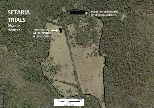
Figure 1. Aerial view of the Setaria-dominated clearing at Minyuma IPA prior to restoration work . The trial area arrowed is the location of the preliminary trial of herbiciding plus fire followed by regular spot spraying of weed regrowth. The project was then expanded to much of clearing to the left of the artificial drain running through the centre of the site (Photo Minyuma IPA)

Introduction. ‘Minyumai’ is an approx. 2000ha property owned by Minyumai Landholding Aboriginal Corporation (MLHAC) and managed by the MLAC board and the Minyumai Rangers. The property is located on the far north coast of NSW, adjacent to Bundjalung National Park and Tabbimoble Nature Reserve and was dedicated as an Indigenous Protected Area (IPA) in 2011. 

The property is largely comprised of native ecosystems, including five Endangered Ecological Communities (EECs), however it has a history of grazing in largely three sizeable clearings.  The largest and most degraded of these clearings (the ‘middle clearing’) (Figs. 1 and 2) became known to the Rangers as the ‘Setaria plots’ as it was almost completely devoid of trees, was dominated by the introduced pasture grass Setaria (Setaria sphacelata) and was subsequently divided into multiple plots for treatment and monitoring.
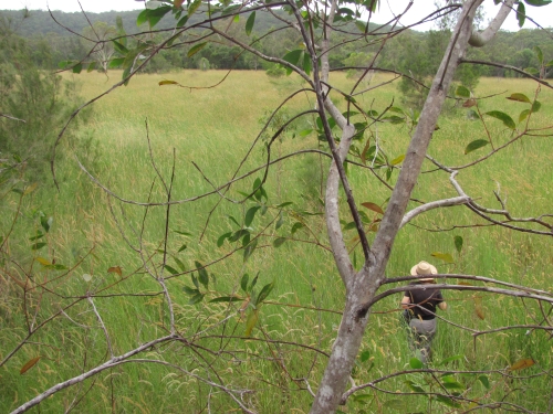
Figure 2. Closer view of the density and cover of Setaria at the site prior to treatment. (Photo Minyuma IPA)

The purpose of the work in the Setaria plots is to convert the vegetation from weed dominance to dominance by native species of the site’s prior ‘Swamp sclerophyll forest on coastal floodplains’ EEC. The project started in 2014 and is an ongoing part of the Ranger’s regular works program. 

Works undertaken. After a successful trial sponsored by Firesticks in an adjacent area, a facilitated natural regeneration approach was adopted in the Setaria plots, supplemented by some tree planting. While there were little or no above-ground natives evident among the mature Setaria at the start of the project (Fig 2), the Firesticks trial showed that the use of fire followed by precision weed spraying would result in at least some regeneration of native ground covers from the soil seed bank.
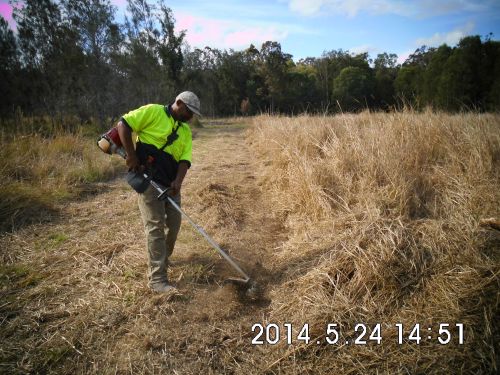
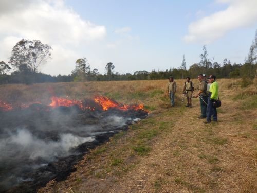
Figure 3. Firebreaks were installed at the site prior to spraying and burning and remain maintained to allow for ongoing use of fire during over time should it prove beneficial. (Photo Minyuma IPA)
Figure 4. Minyumai Rangers and visitors from a neighbouring IPA running a burn on the site. (Photo Minyuma IPA)

The plot-by-plot approach subsequently adopted involved creating firebreaks, overspraying the mature setaria with 1% glyphosate and subsequent burning of the dried weed biomass (Figs 3 and 4).  Subsequent follow-up spot-spraying was then systematically and regularly carried out.

Monitoring.  The project offered an opportunity to separate and compare burn and spray treatments with spray-only treatments – i.e.  all plots (except untreated controls) were subjected to systematic weed management but some were additionally burnt.  Species counts and cover was measured at 2 years of age and again at 4 years of age – with the ground stratum monitored using 15 quadrats (7 burn+spray, 6 spray only and 3 controls) and woody cover monitored using 18  (20m) transects (line intercepts).
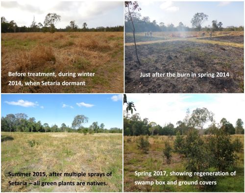
Figure 5. Photopoint monitoring showing changes at the site over a 3 year period showing treatments and gradual regeneration of natives. (Photos Minyuma IPA)

Results to date.  While the initial follow up treatments revealed extensive weed, this rapidly transitioned to native dominance over time (Fig 5) and with fairly rigorous herbicide treatment of all weed by the Rangers.  The site developed high levels of cover within 18 months. A total of  37 native species were recorded over the four years (including 5 trees, 2 shrubs,  1 vine, 18 forbs, 7 sedges and 4 grasses) .  A total of 26 weed species (1 shrub, 14 forbs, 2 sedges and 9 grasses) occurred and while weed cover reduced over time ) most species of weed remained present in the system.  

The quadrat data showed that the fire plus spot-spraying treatment resulted in improved native cover in the ground stratum (scoring an average of 3.38 on a 5 level cover scale)  compared to spot-spraying alone (scoring an average of 2.17 on the 5-level cover scale) with the controls remaining in the lowest cover level.

Transect monitoring of woody species cover over time showed a significant increase in tree cover after both fire plus spray (n=5)  and spray alone (n=9) treatments compared to the untreated controls (n=4) but there was no significant difference between the burn plus spray and spray only  treatments, which is understandable as none of the tree species form soil seed banks.
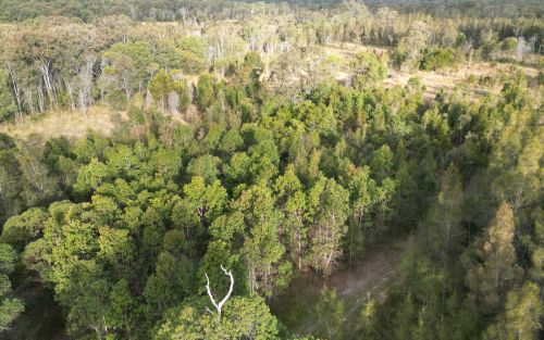
Figure 6.  Drone photo of the same quadrats from the air in August 2023, nine years after the work commenced. The dense green tree growth in the middle of the photo is all regrowth on the treated plots. Between this area and the intact Paperbark forest in the further distance there is a band of untreated land still dominated by Setaria and without native colonisation. (Note the Eucalypt circled is the same Eucalypt in the right hand background of the photos in Figure 5.)   (Photo G. Little)

Changes over time. The sedges, which were initially abundant in the understorey,  became less abundant over the two readings. Native grasses were initially far less common but increased over time, and 10 years on are still far less prevalent than sedges, which makes sense considering the wetland nature of the site.

Some  forbs, such as Buttercups (Ranunculus spp.), Gotu Kola (Centella asiatica), Pennyworts (Hydryocotyle spp.), Kidney Weed (Dichondra repens) and Native St Johns Wort (Hypericum perforatum) became frequent or abundant and remained so over the monitoring period. while other forbs such as Grass Lily (Murdannia graminea), Ludwigia (Ludwigia and Native Bluebell (Wahlenbergia sp.) remained uncommon or even rare.

Over the 10 years since the project began, the tree species Swamp Box (Lophosptemon suaveolens), Swamp Oak (Casuarina glauca) and Broad-leaved Paperbark (Melaleuca quinquinervia) have all become markedly more abundant over time through colonisation from the surrounding forest (Fig. 6) – with natural regeneration far outweighing any tree planting efforts made at the start of the project.  Forest Red Gum (Eucalyptus tereticornis) did not however increase from the remnant tree on site nor did planted seedlings of this species survive.   

Lessons learned and future directions.  When comparing the treated areas with untreated areas it is clear that the native tree colonisaton is confined to the treated areas. Although the treated areas developed high native herbaceous cover it is likely that the open niches created by the weed control and fire allowed colonisation by trees, while the dense Setaria cover prevented regrowth. 

A major challenge has been the presence of wild cattle on the property that have proved resistant to capture. This required electric fencing of the site for some years to avoid damage to plantings, although natural regeneration has now overtaken the plantings.

Critical to success was rigorous follow up prior to the weed reseeding.  Complete avoidance of reseeding was not always possible due to funding limitations or personnel changes. This has resulted in some reinvasion of Setaria in some of the plots, although the Rangers continue to manage the site well. 

As the mown firebreaks are still in place, there is potential for cool fire to be reintroduced into the site (followed by further weed control) should this be considered ecologically beneficial.  The site may also benefit from a project (being conducted in collaboration with Nature Glenelg Trust) to fill in the artificial drain visible in Fig 1.

Stakeholders and Funding bodies.  We acknowledge the valuable contributions of all the Minyumai IPA Rangers, particularly the early leadership of Minyumai Rangers, Daniel Gomes, Justin Gomes and Belinda Gomes. The Commonwealth Government’s IPA program funded the delivery of biodiversity management services by MLHAC, and funding and advice for the fire trials was provided by the NSW Nature Conservation Council’s  Firesticks initiative, with advice from Oliver Costello and Richard Brittingham. Tein McDonald advised on techniques and monitoring and Andrew Johnston provided training for the Minyumai Rangers in the first years of the project.

Contact: Mary Wilson, Minyumai Land Holding Aboriginal Corporation. Email: <admin@minyumai.org.au>

Eradicating weeds along the Tasmanian Wilderness World Heritage Area coastline

Jon Marsden-Smedley

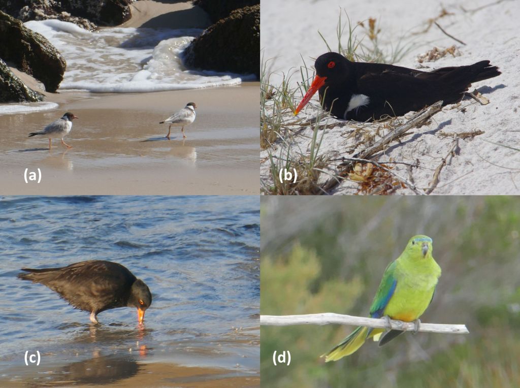
Figure 1. The project supports multiple bird species including the vulnerable (a) Hooded Plover, (b) Australian Pied Oystercatcher, (c) Sooty Oystercatcher and (c) the critically endangered Orange-bellied Parrot. (Photos J. Marsden-Smedley)

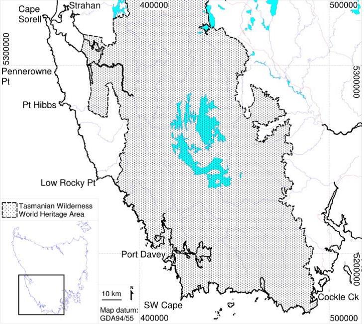
Introduction. The Tasmanian Wilderness World Heritage Area (TWWHA) in the southwest of Tasmania is an important area for conservation. The coastline of this region has high natural integrity and is a major stronghold for a number of shore-nesting and feeding birds including the vulnerable Hooded Plover (Thinornis cucullatus), Australian Pied Oystercatcher (Haematopus longirostris), Sooty Oystercatcher (Haematopus fuliginosus) and the critically endangered Orange-bellied Parrot (Neophema chrysogaster) during its migration (Fig. 1). Three ecosystem-transforming weed species: Sea Spurge (Euphorbia paralias), Marram Grass (Ammophila arenaria) and Blackberry (Rubus fruticosus aggregate) have the potential to transform the coastline’s geomorphic structure and have been identified as major threats to environmental and cultural value. It is estimated that about 425 km of the 850 km coastline in the TWWHA is susceptible to Sea Spurge and / or Marram Grass invasion.

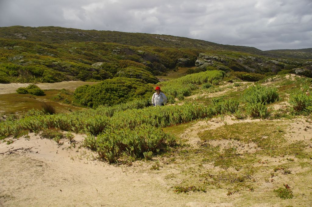
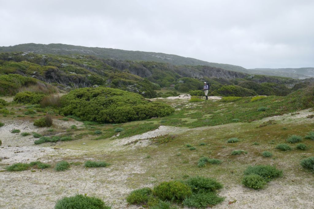
The WildCare volunteer group SPRATS (Sea sPurge Remote Area TeamS) has been undertaking annual weed management works along the TWWHA coastline between Cape Sorell (Macquarie Harbour) and Cockle Creek since 2006 (Fig. 1). SPRATS is a self-managing volunteer group working in partnership with the Tasmanian Parks and Wildlife Service (PWS). The primary goal of the program is to initially control and then eradicate Sea Spurge and Marram Grass from the coastline (Figs 2-4). The secondary goal is to eradicate any Blackberry infestations found and monitor for other weeds.

Figure 2. The SPRATS work area.

Logistics. The SPRATS weeding program has divided the coastline into eight sectors. At the start of each weeding season, detailed maps are prepared showing weeding sites, campsites and walking routes. These data are uploaded into GPS units so that all groups can efficiently and easily locate previously recorded weed sites, campsites and walking routes. Teams of SPRATS volunteers walk each section of the coastline of the TWWHA annually. While undertaking weed control and monitoring, volunteers also record information on rare and threatened shorebird species, assist with research into the ecology of the region (e.g., collection of Tasmanian Devil scats for genetic analysis), record the location of Aboriginal cultural sites (e.g., petroglyphs, stone arrangements, middens and hut sites) and the usage of the area by other groups (e.g., quad bike riders).

Works undertaken. In the first three years of the program, weeding efforts were concentrated in the southernmost susceptible areas. Once these Sea Spurge infestations had been given an initial knock-down, efforts moved to very large infestations along 45 km of coast south of Cape Sorell. Work then expanded to include about 160 km of coastline in Macquarie Harbour.

Trials were conducted in 2009-2010 to compare both the kill rates of target species and impacts on non-target species of different herbicide treatments. These trials identified glyphosate mixed with Pulse® as the best herbicide treatment for Sea Spurge.

Different strategies have been utilised at different stages of the program. Heli-spraying operations have been used to knock down very large Sea Spurge infestations (i.e., infestations of > 250,000 plants) and the subsequent massive seed germination event. Two rounds of heli-spraying reduced the number of Sea Spurge plants by 90% and enabled subsequent hand weeding. The optimum technique identified for treating Marram Grass was to spot spray with Haloxyfop-R methyl ester and penetrant. This is followed up by hand weeding once weed densities are reduced.

A feature of the SPRATS work program is collection of geo-referenced data on all weeds removed,  along with targeted research into the most effective treatment methods. These data are used to demonstrate work effectiveness, plan annual work programs and report back to the PWS and other funding bodies.

A major development in the past two seasons has been testing and spreading the Sea Spurge biocontrol recently developed by the CSIRO. This biocontrol has the potential to provide a long term solution to the issues associated with Sea Spurge. From 2006 to 2022-23, 8504 work days have been completed, most of which has been volunteer effort.

Figure 3. A SPRATS volunteer standing in a patch of Sea Spurge at the Sassy Creek site in 2007. (Photo J. Marsden-Smedley)

Figure 4. The Sassy Creek site in 2021. (Photo J. Marsden-Smedley)

Results to date. Prior to the start of the program it was estimated that the TWWHA region contained about 11.1 million Sea Spurge plants and about 124 000 Marram Grass clumps located in over 700 sites. By 2022-2023 weeds had been mapped from over 850 sites, made up of about 700 Sea Spurge, 150 Marram Grass, four Blackberry, three Great Mullein and one Slender Thistle. To date the SPRATS program has removed over 14.4 million Sea Spurge plants (about 99.7%). In the 2022-2023 weeding season about 2795 clumps of Marram Grass were sprayed representing a 98% reduction on the pre-SPRATS number of marram grass clumps. The region’s known blackberry infestations have been eradicated.

Challenges. A major challenge is missed Sea Spurge sites. In its second year of growth, Sea Spurge produces a large number of seeds which then germinate or replenish seed banks. Seedlings from these reactivated sites are responsible for between a third and half of Sea Spurge plants treated and the rate at which SPRATS is reducing the number of Sea Spurge is slowing. It appears likely that there are an increasing number of Sea Spurge seeds washing in from very large infestations to the north of the TWWHA and also along the east coast of Tasmania. If the Sea Spurge biocontrol is found to be effective, this issue should be addressed by large scale spreading of the biocontrol agent which should reduce these very large infestations. It may also be necessary to do targeted releases of the biocontrol within the TWWHA.  

In the early years of SPRATS operations, treating Marram Grass was rated as a lower priority than Sea Spurge. Marram Grass identification and weeding is also slower, more laborious and difficult than sea spurge weeding. Marram Grass weeding involves spraying, wiping of individual leaves with herbicide or digging out entire clumps. In recent seasons, improved training in Marram Grass identification and the use of the monocotyledon specific herbicides has resulted in a significant increase in the rate of Marram Grass removal.

Stakeholders and Funding bodies:  The SPRATS program has been supported by theTasmanian Parks and Wildlife Service, WildCare, and in the early part of the project, the Australian  government’s Caring for Country program.

Contact information: Jon Marsden-Smedley, SPRATS (M) 0456 992 201 (E) jon.marsdensmedley@gmail.com  / sprats.tas@gmail.com

Shorebird habitat restoration in the Hunter Wetlands National Park

By Tom Clarke

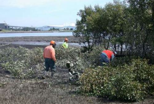
Figure 1. Contractors felling mangrove trees to restore migratory shorebird habitat structure at Stockton Sandspit.

Introduction. Thirty-seven species of migratory shorebirds regularly visit Australia, with all but one spending up to 6 months of each year here. Globally, populations of some migratory shorebirds have declined by 80% over the last 30 years largely due to habitat destruction and disturbance along the East Asian-Australasian Flyway. Within Australia, degradation of feeding and roosting habitats and disturbance are the major threats. Shorebirds need access to safe roosting places. Typically, a favoured roost is close to feeding areas, has a wide-open space and a clear view of the water. A clear view is needed for predator avoidance. A major issue for shorebirds in the Hunter Estuary, indeed for the entire flyway, is having access to several roosts so that alternative sites are available when conditions and levels of disturbance become intolerable at the preferred roost.

In the late 1990s it became obvious that vegetation encroachment was degrading major roost sites in the Hunter Estuary. Of particular concern was the viability of Stockton Sandspit, a shorebird roost site of national importance. Mangrove encroachment along the beachfront was creating a wall of vegetation and effectively blocking the view of the water. Woody weeds were also encroaching on the roost area resulting in a large decline in shorebird numbers using the roost site.

Mangrove encroachment has been documented in several estuaries along the east coast of Australia. Halting encroachment is not an option but managing specific areas that are important for shorebirds is achievable. This project involves the removal of mangroves adjacent to favoured roosting sites to maintain low, open spaces with a clear view of the water, with the intent of maintaining the sites  for shorebirds as long as they keep turning up. The potential recovery of coastal saltmarsh in these sites is an added bonus as saltmarsh is an endangered ecological community.

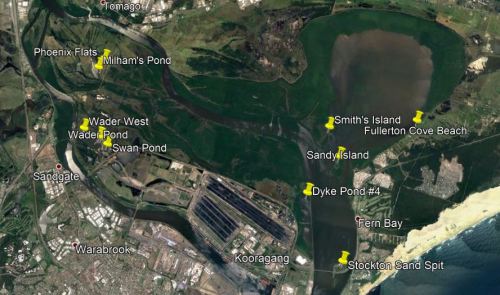
Figure 2.  Main shorebird habitat restoration sites in Hunter Wetlands National Park.

Works undertaken. Mangroves are normally protected vegetation by law. After it was agreed by various stakeholders that mangroves should be cleared from Stockton Sandspit, a permit to remove mangroves was applied for from Department of Primary Industries (Fisheries). The initial permit allowed for the removal of mature mangroves from an area of less than 1 hectare. This primary work was carried out by contractors (Fig. 1). The funding agreement required matching volunteer effort. Initially, volunteer work involved Hunter Bird Observer’s Club (HBOC) monitoring the shorebirds, but this was quickly augmented by on-ground work to remove woody weeds (including Lantana Lantana camara, Bitou Bush Chysanthemoides monilifera ssp. rotundata and Telegraph Weed Heterotheca grandiflora) and reduce the density of native shrubs (including Acacia spp, Banksia spp. and Leptospermum spp.) from the roost area. Weeding also aimed to remove exotic rushes from a small area of saltmarsh. Following initial success, other shorebird roost sites in the Hunter Estuary with similar threats were added to the program (Fig. 2). These additional areas were selected using data from the shorebird monitoring being conducted by HBOC. At each site, an initial primary effort by contractors is followed up by HBOC volunteers and others. The project has been running continuously since 2002 and represents the HBOC commitment to caring for these endangered birds.

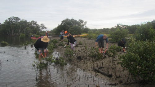
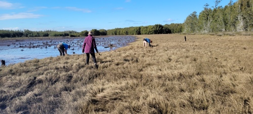
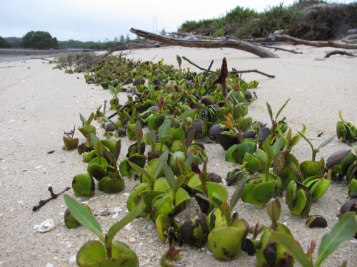
Over 10,900 volunteer hours has been accrued to date through the efforts of over 480 persons and the program is ongoing. Today, the project maintains nearly 150 hectares of shorebird habitat in Hunter Wetlands National Park. From March through to July each year, a program of works is scheduled to take advantage of favourable tides to access work areas. These cooler months are better for working in exposed areas and are when the population of migratory shorebirds is at its lowest. Removal of mangrove seedlings takes up most of the ongoing volunteer effort (Figs 3-6). The level of recruitment of mangrove seedlings varies from year to year and site to site. Factors such as tide height, wind direction and flood levels at the time of seed-drop affect the distribution of the seeds. Seed-drop usually occurs from the end of August through to early November with the majority falling through September. However, over the eighteen months of wet weather following the prolonged drought that ended in early 2020, mangrove seeds were washing up every month of the year. This required a massive effort to clear mangrove seedlings from all the sites in 2022. Thankfully the effort required in 2023 was back at a sustainable level.

Figure 3. Intrepid Landcarers cutting mangroves on Smith Island. (Photo T. Clarke)

Figure 4. Volunteers sweeping the marshes at Stockton Sandspit. (Photo T. Clarke)

Results to date. Removal of fringing mangroves and woody weeds from the roost area had an immediate positive effect. Most of the shorebirds quickly re-occupied Stockton Sandspit. This continues to be the case with Stockton Sandspit being one of the main daytime roosts used in the Hunter Estuary. Similar success has occurred at other sites but has not been quite as outstanding. These sites tend to be used by smaller aggregations of birds but are complementary to the Stockton Sandspit as different shorebird species prefer them. Some of the additional sites are frequently used as back-up roost sites when the preferred site is suffering unusually high levels of disturbance, often due to human activity.

Figure 5. Final sweeps over Milham Pond by Hunter Bird Observers Club volunteers in 2022. (Photo T. Clarke)

Figure 6. Mass drop of mangrove seeds happens every year at Stockton Sandspit and other places. Six months later the surviving seedlings are removed by volunteers. (Photo T. Clarke)

Lessons learned and future directions. Working on the inter-tidal areas has required that we develop an understanding of how the estuary system operates. In the early years lots of tide notes were collected for each site as well as shorebird movements. Utilising favourable tides gives better access and improves efficiency. Understanding certain shorebird behaviours also improves our efficiency. Quite often, a couple of forward scouts in the form of godwit or curlew will fly over a roost site on an inspection loop prior to the main rush of the various flocks. This is the signal for workers that it is time to vacate the site.

Many techniques and a variety of hand tools have been trialled with differing levels of success. Hand-pulling the seedlings has proven to be the most efficient. We have found that it is possible to manage the mangroves without the use of chemicals. Cutting stems lower than the next high tide results in the stumps being immersed and the tree dies. This also works for seedlings that are snapped-off. In situations where the substrate is firm enough, seedlings can be snapped off at ground level using a hoe. However, this method doesn’t work in soft mud as the plant bends away rather than breaking. Where seedling recruitment is dense, a battery-powered brush cutter has been utilised. This method was very useful during the year of continuous seeding.

While the initial work was motivated by a sense of obligation to intervene, the ongoing work provides positive feedback that maintains the energy and brings much satisfaction to the carers. This happens on every occasion that we witness the arrival of the shorebirds to the places that are restored each year, a positive joy. Maintenance of the various roost sites has become a wonderful opportunity to introduce people to shorebirds.

Stakeholders and funding bodies. At each stage of the project an initial effort of primary works was carried out by contractors and funded through various Government programs including the Australian Government’s Caring for Our Country, Envirofund and Threatened Species Recovery Fund.   The following have supported the works in some manner over the last twenty years; Twitchathon, Bird Interest Group Network (BIGNet), Birdlife Australia,  Conservation Volunteers Australia, the NSW Departments of Primary Industries and Fisheries, and Planning and Environment (and their predecessors), Hunter Bird Observers Club, Hunter Catchment Management Authority, Hunter Local Land Services, Hunter Regional Landcare Network, Kooragang Wetlands Rehabilitation Project, NSW National Parks & Wildlife Service, Newcastle Kayak Tours, Newcastle City Council, Newcastle Coal Infrastructure Group, NSW Government, Toolijooa, Trees In Newcastle, University of Newcastle.

The volunteer effort has been led by members of HBOC that make up the core team. Additional contributions have been made from other groups from time to time including: Better Earth Teams, Green Army, International Student Volunteers, TAFE students, Koora Gang, Intrepid Landcare, Worimi Green Team, Stockton Scouts, Raymond Terrace Scouts, Al Gazzali and Rigpa Buddists.

Contact information. For more information contact Tom Clarke thomas.clarke7@bigpond.com and project reports can be viewed on the HBOC website Rehabilitation Projects – Hunter Bird Observers Club (hboc.org.au).

Biological and cultural restoration at McDonald’s Swamp in northern Victoria, Australia

Dixie Patten (Barapa Wemba Working for Country Committee) and Damien Cook (Wetland Revival Trust.

Introduction. McDonald’s Swamp is a 164-ha wetland of high ecological and cultural significance, and is one of the Mid Murray Wetlands in northern Victoria. The restoration this wetland is part of broader project, led by the Indigenous Barapa Wamba Water for Country Committee in collaboration with the Wetlands Revival Trust, to address the loss of thousands of wetland trees and associated understorey  plants that were killed by poor agricultural and water management that caused prolonged water logging and an elevated the saline water table.

Figure 1. Laura Kirby of the Barapa Wamba Water for Country restoration team beside plantings of two culturally important plants that are becoming well established; Common Nardoo (Marsilea drummondii) and Poong’ort (Carex tereticaulis). (Photo D. Cook.)

The project has a strong underpinning philosophy of reconciliation as it is a collaboration between the Wetland Revival Trust and Aboriginal Traditional Owners on Country – access to which was denied to our people for a long time, disallowing us to practice our own culture and have places to teach our younger generations.  One of the main aims of the project is  to employ Barapa and Wemba people on our own land (Fig 1), not only to restore the Country’s health but also to provide opportunities for a deeper healing for us people. Many of the species we are planting are significant cultural food plants or medicine plants. Indeed it’s actually about restoring people’s relationships with each other –Indigenous and non-Indigenous Australians – and maintaining our connection to  Country.

Over recent years the hydrology of many wetlands in the Kerang region has been vastly improved by a combination of drought, permanently improved irrigation practices in the catchment and the delivery of environmental water.  This has restored a more natural wetting and drying cycle that will enable regeneration of some prior species, largely through colonisation from the wetland edges and through reintroduction by waterbirds.

However, supplementary planting is needed to accelerate the recovery of keystone species at all strata and the ~50 ha of the wetland that has been assessed as highly degraded with little potential f or in-situ recovery from soil-stored seedbanks.

Figure 2. Aquatic species planted at McDonald’s Swamp, including Robust Water-milfoil (Myriophyllum papillosum), Common Water Ribbons (Cycnogeton procerum) and the endangered Wavy Marshwort (Nymphoides crenata). (Photo D. Cook)

Works undertaken: To date the project has employed 32 Traditional Owners, planting out and guarding canopy trees to replace those that have died, undertaking weed control, and replanting wetland understorey vegetation.

Over a period of 5 years,, around 60% of the presumed pre-existing species, including all functional groups, have been reintroduced to the site, involving 7000 plants over 80 ha of wetland. This includes scattered plantings of the canopy species River Red Gum (Eucalyptus camaldulensis), Black Box (Eucalyptus largiflorens) and Eumong (Acacia stenophylla).  Dense nodes have also been planted of a wide diversity of herbaceous wetland species including water ribbons (Cycnogeton spp.), Nardoo (Marsilea drummondii) and Old Man Weed (Centipeda cunninghamii). These nodes have been protected from waterbird grazing by netting structures for 3-6 months, after which time they have reproduced and spread their seeds and begun recruiting throughout the broader wetland..

Some areas of the swamp are dominated by overabundant native reeds due extended inundation in the past.  Such reeds – including Cumbungi (Typha orientalis) and Common Reed (Phragmites australis) – will be future targets for burning or cutting followed by flooding by environmental watering to reduce their abundance prior to reintroduction and recolonization by other indigenous species.

Figure 3. Prolific regeneration of the nationally endangered Stiff Grounsel (Senecio behrianus). The species is presumed extinct in South Australia and New South Wales and is now only known only from 5 wild and 6 re-introduced populations in Victoria. (Photo G Little)

Outcomes to date: Very high establishment and growth rates have been attained for the canopy tree species, many individuals of which have flowered and set seed within the 6 years since project commencement.  All the planted understorey species are now recruiting very well – particularly the Water Ribbons (Cycnogeton procerum and C. multifructum), Floating Pondweed (Potamogeton  cheesmannii), Common Nardoo (Marselia drummondii), Wavy Marshwort (Nymphoides crenata), Water Milfoils (Myriophyllum papillosum  and M. crispatum), Forde Poa (Poa fordeana), Swamp Wallaby-grass  (Amphibromus nervosus), River Swamp Wallaby-grass (Amphibromus fluitans) and the nationally endangered Stiff Groundsel (Senecio behrianus) (Fig.  3.).  The important Brolga (Antigone rubicunda) nesting plant Cane Grass (Eragrostis infecunda) has also spread vegetatively.  Where hundreds of individuals were planted, there are now many thousands recruiting from seed, building more and more potential to recruit and spread within the wetland.

After 7 years of a more natural wetting and drying regime, natural regeneration has also occurred of a range of native understorey species including populations of the important habitat plant Tangled Lignum (Duma florulenta), Lagoon Saltbush (Atriplex suberecta) and Common Spike-rush (Elaeocharis acuta) (Fig 4.).

Figure 4. Planted River Red Gum (Eucalyptus camaldulensis) and naturally regenerating Tangled Lignum (Duma florulenta) and a range of other native colonisers and some herbaceous weed at McDonald’s Swamp some6 years after hydrological amendment and supplementary planting. (Photo T McDonald)

Stakeholders:  Barapa Land and Water, Barapa Wamba Water for Country Committee, Parks Victoria, Department of Environment, Land, Water and Planning and the North Central Catchment Management Authority.

Contact: Damien Cook, Wetland Revival Trust, Email: damien@wetlandrevivaltrust.org

Post-fire assisted regeneration at Rutidosis Ridge, Scottsdale Reserve, Bredbo NSW


Figure 1. Undamaged grassy woodland reference site occurring at high elevation at Scottsdale (Photo: Brett Howland)

Introduction. Scottsdale Reserve is a 1,328-hectare private conservation reserve, near Bredbo NSW, owned and managed by Bush Heritage Australia. For over 100 years prior to purchase in 2006 the property was utilised for grazing and cropping. While most of the higher elevation areas of the property remained intact and offered the basis for improving landscape connectivity for wildlife, the agricultural land use had resulted in conversion of the flats and lower slopes of the property to largely exotic pasture species and accompanying weed.

This case study focuses on one approx 10 ha Apple Box (Eucalyptus bridgesiana) / Snow Gum, (Eucalyptus pauciflora) grassy woodland ridge within the property – named ‘Rutidosis Ridge’ because it is the location of a small population of the Endangered plant species Button Wrinklewort (Rutidosis leptorhynchoides). Set-grazing by sheep as well as some cropping had left the site nearly wholly dominated by the landscape-transforming exotic pasture grasses African Love Grass (Eragrostis curvula) and Serrated Tussock (Nasella tricotoma). Some scattered copses of eucalypts and some herbaceous natives remained, however, suggesting that the site might have some native regeneration potential, but the number and abundance of natives on the site appeared very low and the site was very dissimilar to a nearby healthy reference site (Fig. 1).

Works undertaken. Around a decade after land purchase and the discontinuation of grazing and cropping, Rutidosis Ridge was aerially sprayed during winter with flupropinate herbicide at a low dilution (1L / ha) known to be effective on some strains of African Love Grass and Serrated Tussock without killing native grasses and forbs. While the African Love Grass and Serrated Tussock had died by the following spring as a result of this soil-active herbicide, no substantial native regeneration was observed due to the persistence of the thick thatch of dead African Love Grass (Fig 2).

  • Figure 2.  Typical site showing sprayed African Love Grass thatch even many years after aerial spraying. (Photo T. McDonald )
  • Figure 3.  Intense wildfire that passed through Bredbo, NSW in early February. (Photo” New York Times)

An intense wildfire passed through the property on 2nd February 2020 (Fig. 3). This largely consumed the thatch, exposing stony topsoils and providing opportunities for regeneration of both natives and weeds that were stored in the soil seed bank.  Anticipating the need for post-fire spot-spray follow-up after the fire to avoid any native regeneration being overwhelmed by weed, Bush Heritage Australia (BHA) collaborated on a program of regular selective treatment of weed with the restoration organisation the Australian Association of Bush Regenerators (AABR). Personnel involved both contractors and volunteers skilled in recognising natives and weeds at seedling stage capable of spot-spraying with negligible off-target damage (Fig 4).  

Because the fire had removed African Love Grass thatch and cued germination of natives and weeds, the aim was to treat all weed prior to its seeding.  This allowed the managers to (a) take advantage of the fire’s flushing out the weed soil seed bank and avoid its further recharge and (b) retain maximum open spaces for further natives to emerge and colonise. 

During the year after the fire (March 2020-April 2021), the ~10ha site had been subjected to approx. 600 person hours of spot spraying, mainly undertaken by experienced bush regenerators. This commenced in March 2000 and continued at least fortnightly during the growing season.

Figure 4. Location of comprehensively spot-sprayed areas and target-weeded areas at Rutidosis Ridge. An opportunity exists to compare differences in richness and cover of natives and weed between the two treatments, ensuring comparisons are confined to within-comparable condition classes.

What we found by 1 year of treatments.  Post-fire observations in  March 2020 revealed Snow Gum resprouting from lignotubers and roots and Apple Box and Candlebark (Eucalyptus rubida) resprouting epicormically.  A wide suite of native grasses and forbs were starting to resprout or germinate alongside diverse herbaceous weeds. Within the first 12 months of regular spot-spraying, the cover and seed production of approx. 30 weed species was very substantially reduced.  Combined with fairly evenly distributed rainfall in the follow 12 months this reduction in weed allowed ongoing increases in native species cover and diversity per unit area, with seed production likely by most native species.  There was negligible off-target damage from the spray treatments. In December 2020 over 50 native herbaceous and sub-shrub species (including at least 11 Asteraceae, 9 Poaceae, 4 Fabaceae and 2 Liliaceae) were recorded within the work zones, with cover of natives very high in the higher condition zones, but plentiful bare ground remaining in the lower condition zones (Fig. 5).  

Figure 5.  Top:  Directly after wildfire showing black stubs of African Love Grass; Middle: Volunteers spot-spraying during the growing season, and Bottom: same site after 12 months but when native grasses were curing off after seeding. (Photos T. McDonald)

Predominant weed species included recovery African Love Grass, Viper’s Bugloss (Echium vulgare), St John’s Wort (Hypericum perforatum), Yellow Catsear (Hypochoeris radicata), Common Plantain (Plantago major), a range of thistles and around 20 other weed species.

Predominant natives included speargrasses (Austrostipa spp.), Redleg Grass (Bothriochloa macrantha), Kangaroo Grass (Themeda triandra), Native Panic (Panicum effusum), Common Raspwort (Gonocarpus teucrioides), Bindweed (Convolvulus erubescens), bluebells (Wahlenbergia spp.), Common Everlasting (Chrysocephalum apiculatum), fuzzweeds (Vitadennia spp.), Bear’s Ear (Cymbonotus lawsonianus), Creamy Candles (Stackhousia monogyna), Yellow Pimelea (Pimelea curviflora subsp. fusiformis) and Native St John’s Wort (Hypericum gramineum).  Species of higher conservation interest that regenerated included Blue Devil (Eryngium ovinum) and Threatened species that regenerated included Silky Swainson’s Pea (Swainsona sericea) and Button Wrinklewort. (Some of these species are pictured in Fig. 6).

Figure 6. Some of the forbs that flowered on Rutidosis Ridge during the growing season – including the Endangered Button Wrinklework (centre) and Vulnerable Silky Swainson’s Pea.(bottom left). (Photos various.)

Gradient of condition improving over time. As expected, the sites showed a gradient of condition (Fig. 7), with highest natural regeneration capacity retained in the tree clusters and stony crest, perhaps due to these less likely to be less favoured by sheep. (The tree clusters appear not to have been used as sheep camps). By March 2020, 1 year after work commenced, all sites were on a trajectory to move to the next higher condition class, assuming successful Winter 2021 aerial spray re-treatment of African Love Grass.  (Note that, while the pre-fire flupropinate treatment would normally have a residual effect for a few years and thus preventing germnation of this species, massive germination did occur of African Love Grass in many areas, which we speculate was either due to suitable post-fire germination conditions being delayed by the presence of dead grass thatch or to a possible denaturing of the chemical by the fire.)  

Figure 7. Condition classes in the Rutidosis Zones A-E revealed during the first few months of treatment. By the end of the growing season and after regular follow up spot-spraying it was clear that all zones comprehensively treated were improving in their native: weed cover ratio except for an increasing cover of African Love Grass, the treatment of which was deferred until a second aerial spray scheduled for winter 2021. (Map: T. McDonald)

Acknowledgements: This project would not have been possible without the help of BHA and AABR volunteers.

Contact: Tein McDonald and Phil Palmer, Scottsdale Tel: +61 (0) 447 860 613; Email: <teinm@ozemail.com.au and phil.palmer@bushheritage.org.au


Regenerating and planting of rainforest buffers to protect homes and rainforest from future fires

Joanne Green, Rainer Hartlieb and Zia Flook

Introduction. The wildfires of November and December, 2019, burnt over 5,500 hectares of Nightcap National Park and the surrounding areas, including the rural communities of Huonbrook and Wanganui inland from Byron Bay in NSW, Australia. The fires occurred during a period of extreme fire risk after 2 years with below average rainfall. They mainly burnt the sclerophyll forest along the ridgetops, but the extreme conditions also saw fire burn the edge of the rainforest where it was eventually extinguished.

This summary reports on actions on one multiple occupancy property in Huonbrook, NSW after an ember attack from the Mt Nardi fire entered the property in the early hours of the 9th November 2019. During the fire, residents evacuated.  Their homes were saved but they returned to find that the fire burnt an area of eucalypts  – mainly Flooded Gum (Eucalyptus grandis) and several bamboo species that had been planted during the late 20th century to reforest an area where subtropical rainforest had been-long cleared for dairy farming. The plantings had also become infested with weed including Camphor Laurel (Cinnamomum camphora) and Lantana (Lantana camara), the latter increasing their combustibility under dry conditions. After the fires, the landholders sought solutions that could provide a more fire-resistant barrier to reduce potential fire threat to homes and the nearby remnant rainforest. As a result they opted to restore the buffer zone with the more fire-retardant subtropical rainforest that had been the original native vegetation of the area.

Figure 1. Multiple native and weed species germinated after fire. (Photo Rainforest 4)

Figure 2. Prolific germination of the wind-dispersed Red Cedar (Toona ciliaris), among many rainforest species germinating and resprouting on site. (Photo Joanne Green)

Works undertaken. Starting in March 2020, with support from Madhima Gulgan’s Indigenous bush regeneration team, Huonbrook residents and landowners commenced work on the site. The first task in any zone to be treated was to clear the debris sufficiently to allow access for weeding and planting. The second task was to identify any subtropical rainforest species (germinating after the fire) that were to be retained and to note areas that were bare and would be suited to plantings. (No planting was done where there was any natural regeneration.)  The third task was to remove prolific exotic weeds, while protecting the natives, with the final task involving planting, staking and tree guarding.

The main weed species on site were Lantana, Running Bamboo (Phyllostachys spp.), Kahill Ginger (Hedychium gardnerianum), Winter Senna (Senna x pendula), and Inkweed (Phytolacca octandra). A total of 12 rainforest tree species germinating included the secondary species Red Cedar (Toona ciliaris) and Celerywood (Polyscias elegana) and the pioneers Red Ash (Alphitonia excelsa), Macaranga (Maccaranga tanarius) and Bleeding Heart (Homolanthus populifolius). A total of seven native rainforest understorey species  resprouted including Dianella (Dianella caerulea), Native Ginger (Alpinia caerulea.) and Cordyline (Cordyline petiolaris).

Figure 3. Madhima Gulgan’s Indigenous bush regeneration team assisting  landholders with post-fire weeding.  This work revealed where understorey natives were regenerating and where gaps required planting. (Photo Rainforest 4)

Some  300 rainforest trees (around 30 species) and another 300 understorey plants have been planted at the site to date from May-Sept 2020, with a total of 3600 plants proposed to be planted on additional fire affected sites as part of this project. Locally occurring tree species planted to date include Lillipilly (Acmena smithii), Native Tamarind (Diploglottis australis), Firewheel Tree (Stenocarpus snuatus), and Long-leaved Tuckeroo (Cupaniopsis newmanii) Understorey species planted included Dianella, Lomandra, Native Ginger and Cordyline.  All required tree guards to protect them from browsing by the native Red-necked Pademelon (Thyogale thetis).

After the planting, more natural regeneration of weed and natives occurred, particularly of the ground ferns; Harsh Ground Fern (Hypolepis muelleri), Binung Fern (Christella dentata), and Soft Treefern (Cyathea cooperi). Since the rain in autumn 2020 and the above average rainfall year that has followed, the landholders are managing weed in the regeneration and plantings together and work is now extending into the unburnt buffer zone.

Figure 4. A total of 300 containerised plants were installed to reinstate lowland subtropical rainforest on the site and provide a less fire prone vegetation buffer to protect residential dwellings. (Photo Joanne Green)

Figure 5. Diagram of location of the buffer plantation in relation to dwellings. (Diagram. Joanne Green)

Results to date: Nearly 12 months after planting has seen a nearly 100% survival rate and many of the planted trees have grown to an average height 1-2m. The number of native rainforest species on site now is approximately 25 tree and 23 understorey species and vines.  Ferns cover 40% of the site. The difference between the number planted and the number on site (18 species) can be attributed to natural regeneration.

Further colonisation of rainforest species is expected over time. Whilst, in hindsight, we see that much of the site could have been captured by natives as a result of  weed management alone, the planting has added a broader diversity of species, and will accelerate the process of succession to a more mature rainforest stand.

Acknowledgements: The Madhima Gulgan Indigenous bush regeneration team was funded by the inGrained Foundation and the Rainforest 4 Foundation. See https://www.rainforest4.org/. Technical advice was provided by Joanne Green.

Contact: Rainer Hartlieb, Huonbrook landholder, rainerhart@aapt.net.au and Zia Flook, Rainforest 4 Foundation Conservation Program Manager, zia@rainforestrangers.org

Beyond the 1990s, beyond Iluka – koalas and citizen science – UPDATE of EMR summary

Daniel Lunney, Lisa O’Neill, Alison Matthews, Dionne Coburn and Chris Moon

[Update of EMR summary – Lunney, Daniel, Lisa O’Neill, Alison Matthews and Dionne Coburn ( 2000) “Contribution of community knowledge of vertebrate fauna to management and planning. Ecological Management & Restoration, 1:3, . 175-184. https://onlinelibrary.wiley.com/doi/10.1046/j.1442-8903.2000.00036.x]

Key words: national parks, SEPP 44, adaptive management, social criteria, extinction, wildlife survey, coastal forests.

Figure 1. Interest in local wildlife among residents and visitors to the north coast village of Iluka was growing in the 1990s, providing an opportunity for community involvement in our wildlife survey designed not only to gain information but to raise awareness. (Photo Dan Lunney 1991.)

Introduction. Our EMR feature published in 2000 reported on research that commenced in 1997 when we set out to identify the species and locations of the vertebrate fauna of Iluka peninsula, at the mouth of the Clarence River NSW, Australia. Much of the peninsula had been damaged by post war sand mining and creeping urban growth. We had recognised that there was a growing interest by local communities in conserving biodiversity (Fig 1), as Iluka had residential areas not far from a magnificent Nature Reserve (Iluka NR) and a National Park (Bundjalung NP). We conducted a community-based survey, sent to every household, which used a large, coloured map of the peninsula and a questionnaire asking respondents to mark the locations of the fauna they had seen. As a result of the survey, we concluded that vertebrate fauna does live on private land, that local knowledge is valuable, and that there is both community concern over declining fauna and support for planning, management and long-term fauna research.

Figure 2. Two junior volunteers learning radio-tracking to locate koalas, Iluka Peninsula. (Photo Dan Lunney 1992)

The rise of citizen science. We were not the first to use a community-based survey for wildlife in NSW. A team (Philip Reed and Dan Lunney) in 1986-87 greatly expanded on some skilled, but tentative, efforts to survey Koala (Phascolarctos cinereus) in NSW by the small but effective Fauna Protection Panel. We produced a small questionnaire, which was distributed in 1986, and when we came to analysing the data in 1987, we joined up with CSIRO scientist Paul Walker who had a new tool, GIS, still in its infancy, but which showed great promise. By the time of the Iluka study, GIS was central to our methods.

Over the last 20 years there has been a revolution in the acquisition and application of community knowledge (Figs 2 and 3), a better appreciation of its extent, and limitations, and how to better integrate a greater diversity of disciplines for a more effective planning and management outcome. A Google Scholar search for ‘citizen science’ in July 2019 returned over 2 million results, establishing this phrase in the scientific literature to describe projects that enlist the community for collecting or analyzing scientific data. The rise and success of citizen science undoubtedly stems from the power of the internet and web-based tools that members of the public can use to record species’ locations, providing answers to such questions as: is a species increasing, decreasing or stable? – answers to which increase the capacity for managers and planners to be better targeted in their decisions. Such web-based technology also helps to overcome resource limitations where scale is an important factor. For example, for our 2006 state-wide koala and other wildlife survey we put a major effort into the distribution of the survey, a paper form with a large map. Now, the current 2019 survey is web-based, a procedure we explored in north-west NSW in 2014 where we selected the study area to be 200 by 300 km.

Figure 3. A skilled team climbing a tree to capture a koala for a health check and radio-tracking in a study of the koala population of the Iluka peninsula. (Photo Dan Lunney 1991.)

A further innovation comes from linking sociology to ecology and expanding the term from citizen science to ‘crowd-sourced information’. An example is a study in the four local government areas just north of Iluka, namely Lismore, Byron, Ballina and Tweed. The sociological side, led by Greg Brown, used the threatened koala as a case in point. The study demonstrated a novel, socio-ecological approach for identifying conservation opportunity that spatially connected landscapes with community preferences to prioritize koala recovery strategies at a regional scale. When multiple criteria (ecological, social, and economic) were included in the conservation assessment, we found the social acceptability criterion exerted the greatest influence on spatial conservation priorities. While this is a long way from our 1997 Iluka study, it is in the same lineage and represents two decades of development of what has become a widely accepted approach to regional planning.

Lessons learned and future directions. Looking back at the Iluka story, in one sense, it is a sorry one. When we first started our research on the Iluka peninsula in 1990, there was a visible population of koalas. It dwindled to extinction over the next decade so the locations of koalas in our EMR paper were of recent but fading memories. By defining our study area to a small location, it was possible to identify the cumulative impact of mining, housing, disease, roadkill, dog kill and fire. There have been reports of koalas being back on the peninsula as early as 2002 (Kay Jeffrey, local resident) and there have been subsequent sightings (John Turbill DPIE pers comm August 2019), we presume moving down from such locations as the northern part of Bundjalung National Park

Looking back on our EMR paper, we also see that the Emu (Dromaius novaehollandiae) was one of the most common species recorded by the community on the Iluka peninsula. It has now gone (John Turbill DPIE, pers. comm., August 2019). The coastal Emu population in northern New South Wales is now recognized as being under threat and a citizen science project called ‘Caring for our Coastal Emus’ has been established to collect recent emu sightings from the public using a web-based emu register to pin-point locations on a map. This register is administered by Clarence Valley Council and reflects the shift from the 1990s where the tools and expertise for collecting scientific data for management and planning were beyond the scope of local government. Today, local councils are considerably more engaged in conservation and community education projects.  Indeed, the Clarence Valley Council (2015) has prepared a Comprehensive Koala Plan of Management (CKPoM) for the lower Clarence, which includes Iluka, although it was not adopted beyond council level. The plan recognizes the importance of reducing further clearing and protecting and rehabilitating those areas that remain, and identifies that further studies and monitoring are required to establish the current status of the Iluka koala population.

In the early 1990s, we had prepared a possible plan of management for the koalas of Iluka peninsula but there was no legal incentive to adopt it. Thus, in late 1994, when one of us (DL) was asked by the then NSW Department of Planning and Urban Affairs to help write a SEPP (State Environmental Planning Policy) for koala habitat protection, the potential value of doing so was clear to us. SEPP 44 was written in three days, with a promise to revise it in 1995. SEPP 44 has proved to be valuable, although in recent years, the process of preparing and submitting CKoPMs from councils to the NSW state government seems to have stalled.

In conclusion, our EMR feature was written at the time of an upward inflection in the study of koalas, of fauna survey using crowd-sourced information.  We are now better equipped to use the new techniques from over three decades of what might be described as adaptive management of the ideas in our original EMR paper. We also press the point that research, exploring new ideas, incorporating new techniques and publishing our findings and thoughts make a crucial contribution to conserving not only koalas, but all our wildlife and natural areas, both in and out of reserves.  Such research is therefore vital to the survival of our wildlife.

Stakeholders and Funding bodies: In addition to the funding bodies in our EMR paper of 2000, support for the research supporting the above comments has been extensive, as reflected in the acknowledgements section of each report.

Contact. Daniel Lunney, Department of Planning, Industry and Environment NSW, (PO Box 1967, Hurstville NSW 2220 and the University of Sydney, NSW 2006. dan.lunney@environment.nsw.gov.au).

Ecological restoration in urban environments in New Zealand – UPDATE of EMR feature

Bruce Clarkson, Catherine Kirby and Kiri Wallace

[Update of EMR feature  – Clarkson, B.D. & Kirby, C.L. (2016) Ecological restoration in urban environments in New Zealand. Ecological Management & Restoration, 17:3, 180-190.  https://onlinelibrary.wiley.com/doi/10.1111/emr.12229]

Key words: urban ecology; restoration; indigenous biodiversity; New Zealand

Figure 1. Kauri dieback disease is affecting individual trees (left). [Photo Nick Waipara]

Introduction. Our 2016 EMR feature reviewed the state of research and practice of ecological restoration in urban environments in New Zealand. We concluded that urban restoration can influence and support regional and national biodiversity goals. We also observed that research effort was light, lacking interdisciplinary breadth and may not be sufficiently connected to restoration practice to ensure long-term success of many projects.

While it is only three years since that review was published, urban ecological restoration continues to grow and evolve, and the policy setting and political context have changed significantly. New threats and opportunities have emerged. The spread of a dieback disease and the more recent arrival of myrtle rust, rapid uptake of Predator Free 2050, emergence of the One Billion Trees programme, a surge in housing and subdivision development, and a potentially more supportive policy framework are all major factors.

Threats and opportunities. Kauri dieback disease is severely affecting urban kauri forests and individual Kauri (Agathis australis) trees in Auckland and other northern North Island urban centres (Fig. 1). Large forest areas adjoining Auckland, including most notably the Waitākere Range and large parts of the Hunua Range, are now closed to the public, preventing access to popular recreational areas. The dieback is caused by a fungus-like pathogen Phytophtora agathicida that is spread through soil movement. The disease may have arrived from overseas although this is uncertain. There is no known cure but research efforts are underway to find a large-scale treatment option.

Myrtle rust (Austropuccinia psidii) was first found on mainland New Zealand in May of 2017, probably arriving by wind from Australia. Myrtle rust threatens many iconic New Zealand plant species in the family Myrtaceae including Pōhutukawa (Metrosideros excelsa), Mānuka (Leptospermum scoparium), Rātā (Metrosideros robusta), Kānuka (Kunzea spp.), Waiwaka (Syzygium maire) or Swamp maire, and Ramarama (Lophomyrtus bullata). These species are all used to a greater or lesser extent in restoration planting or as specimen trees or shrubs in urban centres, depending on amenity or ecological context. Mānuka is widely used as a pioneer or nurse crop for native forest restoration and is critical to the economically important mānuka honey industry. Waiwaka is a feature of many swamp forest gully restoration projects in Hamilton and this would be a significant setback if they were badly affected. The impact of myrtle rust is still not clear but experience from Australia suggests it may take several years before it reaches population levels sufficient to cause significant damage.

Figure 2. With rapid housing developments in New Zealand, it is important that urban restoration projects are well-planned and efficiently carried out to provide residents with greenspaces to benefit their cultural, health and wellbeing practices. [Photo Catherine Kirby]

In response to a range of housing issues characterised by many as a New Zealand housing crisis, the previous and current government has embarked on several major initiatives to increase the housing stock. A $1B Housing Infrastructure Fund (HIF) was established in October 2016 with provision for interest free loans to local government to enable opening up of new large areas of housing. Many urban centres including Auckland, Tauranga, Hamilton and Queenstown made early applications to the fund. Hamilton City Council was successful in obtaining $290.4 M support for a new greenfield subdivision in Peacocke on the southern edge of the city. This subdivision is intended to enable development of some 3700 houses over the next 10 years and 8100 in 30 years. Approximately 720 ha of peri-urban pastoral agricultural land would eventually be developed (See summary). Coupled with this, and already in progress, is the construction of the Southern Links state highway and local arterial road network. The first proposed subdivision Amberfield covers 105 ha and consent hearings are currently in progress. The environmental impacts of the proposal and how they might be mitigated are being contested. In brief, survival of a small population of the critically endangered Long-tailed Bat (Chalinolobos turberculatus) is the main environmental focus but other aspects including the extent of greenspace and ecological restoration required for ecological compensation are being considered (Figs. 2, 3). With strong political pressure to solve the housing crisis in Hamilton and in other urban centres, making adequate provision for greenspace, especially urban forest, and preventing environmental degradation and indigenous biodiversity decline will be a major challenge.

Figure 3. Aerial photo of Waiwhakareke Natural Heritage Park (65 ha), an award-winning and ongoing ecological restoration project situated on the edge of urban Hamilton. [Photo Dave Norris]

The Predator Free 2050 (PF2050) programme which gained government (National) approval in 2015, aims to eradicate Stoat (Mustela erminea), Ship Rat (Rattus rattus), Norway Rat (Rattus norvegicus) and Possum (Trichosurus vulpecula) from the whole of New Zealand by 2050 (Department of Conservation 2018). PF2050 is now gaining significant traction in urban environments (Figs. 4, 5) with many urban centres having good numbers of community-led projects underway (See PFNZ National Trust map). Crofton Downs in Wellington was New Zealand’s first predator-free community project. Led by Kelvin Hastie this project has effectively reduced predator numbers to the point that some sensitive native birds e.g. Kākā (Nestor meridionalis), have begun to nest in this suburb after an absence of more than 100 years (See RNZ report). Also in Wellington, the Miramar Peninsula (Te Motu Kairangi) has become a focus, because of its advantageous geography, with a goal to make the area predator free by 2019. Possums had already been exterminated in 2006 (www.temotukairangi.co.nz).

Figure 4. John Innes (Wildlife Ecologist, Manaaki Whenua Landcare Research) demonstrating trapping success. Removing pest mammals reduces predation, and also frees up the habitat and resources for our native fauna and flora to flourish. [Photo Neil Fitzgerald]

The One Billion Trees (1BT) programme was initiated by the new coalition government (Labour, NZ First, Greens) in 2017 with $238M released in 2018 for planting of both exotic and native trees across mixed land use types. It is not clear yet whether urban forest projects have received funding support but the guidelines suggest there is no reason why restoration of native forest in urban settings would not be eligible. While the emphasis is on exotic tree plantations, native species and long-term forest protection are increasingly being considered as viable options by the newly established government forestry agency Te Uru Rākau.

The policy setting for ecological restoration in urban environments is potentially becoming more favourable with the draft National Policy Statement on Indigenous Biodiversity (NPSIB) currently in review and the New Zealand Biodiversity Strategy under revision (See terms of reference). The draft NPSIB emphasises restoration of indigenous habitat in biodiversity depleted environments. Specifically, Policy 19: Restoring indigenous biodiversity depleted environments, recommends a target for indigenous land cover, which in urban areas and peri-urban areas must be at least 10 per cent. The revision of the New Zealand Biodiversity Strategy seems likely to give more emphasis to landscape scale restoration including urban environments.

Figure 5. New Zealand native lizards are extremely vulnerable to mammalian predation (e.g. mice, hedgehogs, ferrets, cats) as well as habitat destruction (e.g. new urban developments). [Photo Tony Wills]

Research update. Using the same targeted Google Scholar search method as reported in the EMR feature we have found 18 new peer reviewed papers published between 2015 and July 2019 (see updated bibliography) that are strongly focused on restoration in New Zealand urban environments. The single paper noted for 2015 was missed in our previous search. Again, we have not included books, book chapters or grey literature. This compares very favourably with the total 27 papers listed in our 2016 review of which more than half dated from 2009. An increasing publication rate confirms increasing interest and research efforts in aspects of urban ecological restoration. While most of the publications remain in the ecological science realm there are now some informed by other disciplines including engineering, psychology, landscape architecture and health sciences.

Most notably since our 2016 review, a new government-funded (Ministry of Business, Innovation and Employment) research programme, People, Cities and Nature, began in November of 2016. This four-year $823 k per annum research programme ends in October of 2020 unless a funding rebid to be submitted in March 2020 is successful. The programme undertakes multidisciplinary research in nine NZ cities via six inter-related projects: restoration plantings; urban lizards; mammalian predators; Māori restoration values; green-space benefits and cross-sector alliances. While the emphasis was on the ecological science of urban restoration at the outset, the programme has become increasingly involved in understanding the multiple benefits of urban ecological projects including social cohesion and health and recreation benefits. The need to connect restoration research and practice has been met by undertaking multi-agency and community workshops involving researchers and practitioners in five cities to date with a further four scheduled before the programme ends.

Acknowledgements. The People Cities and Nature research programme is funded by the Ministry of Business Innovation and Employment under grant number UOW1601.

Information. Bruce D. Clarkson, Environmental Research Institute, University of Waikato, Hamilton, New Zealand bruce.clarkson@waikato.ac.nz; Catherine L. Kirby, Environmental Research Institute, University of Waikato, Hamilton, New Zealand catherine.kirby@waikato.ac.nz; and Kiri J. Wallace, Environmental Research Institute, University of Waikato, Hamilton, New Zealand kiri.wallace@waikato.ac.nz.

Rehabilitation of former Snowy Scheme Sites in Kosciuszko National Park – UPDATE of EMR feature 2019.

Gabriel Wilks

Update of EMR feature – MacPhee, Elizabeth and Gabriel Wilks (2013) Rehabilitation of former Snowy Scheme Sites in Kosciuszko National Park.  Ecological Management & Restoration, 14:3, 159-171. Doi https://onlinelibrary.wiley.com/doi/10.1111/emr.12067

Key words.  Habitat construction, steep slopes, rock spoil.

Figure 1. Shaped rock spoil ready for planting more than 50 years after being dumped.

Introduction. Our original EMR feature article described the origins of this large, long-term rehabilitation program and the challenges faced in the first 10 years. The program’s aim was to address a range of impacts upon montane and sub-alpine vegetation and river corridors in Kosciuszko National Park from the Snowy Hydro Scheme, constructed from 1949 to 1974. Impacts included dumping of large volumes of rock spoil, loss of topsoil and native vegetation, introduction and spread of weeds and asbestos fragments in the landscape.  The article outlined the development of methodologies for restoration, particularly planting trials on steep rock spoils, and how obstacles such as slope instability, plant material availability and lack of soil were being overcome. The process of program implementation was given, including environmental and cultural heritage assessments undertaken as part of site works.  In 2013 a number of positive outcomes were already evident at the 200 sites that had been subjected to at least some treatment, including 18 sites where major rehabilitation works were undertaken. Outcomes included reduction in waterway impacts and invasive weeds, expansion of the Kosciuszko fauna database, regional community benefits, and production of an Australian Alps Rehabilitation Field Guide.

Further work. The Former Snowy Scheme Rehabilitation Program continues to reduce the long term environmental and safety risks of old degraded construction sites to Kosciuszko National Park, as well as improve their visual and ecological function. Some sites treated by 2013 have blended in with the surrounding landscape and are difficult to identify. Many sites are continuing to improve in condition over time, with distinct vegetation layers, natural plant recruitment and evidence of native fauna habitat. Construction history, rock spoil and loss of soil and plant species remain evident at highly altered sites, despite a high standard of rehabilitation work.

An additional 12 Major rehabilitation works have been undertaken since 2013, with selected signature projects and rehabilitation techniques described below.  Note that the former Snowy Scheme rehabilitation program does not address the impact of current Snowy Hydro Limited or proposed infrastructure and support networks such as powerlines, easements, river regulation or roads.

1. Rehabilitation of the Tooma–Tumut Access Tunnel Adit Spoil Dump. This spoil dump (Fig. 1) is located on the highly incised upper reaches of the Tumut River.  The spoil originates from construction in 1958-1961 of the Eucumbene–Tumut Tunnel, which transfers the headwaters of the Tooma River to Tumut Pond. Following earthworks in 2017, the planting crew successfully planted, watered, fertilised and mulched approximately 12,000 plants on rock spoil, with monitoring being undertaken by Greening Australia Capital Region staff (Fig 2.)

Figure 2. Year 1 Revegetation monitoring at Tooma-Tumut SD by Greening Australia Capital Region staff, 2018

2. Construction of contained habitat for the Southern Corroboree Frog. A series of remote enclosures (Fig 3) have been constructed in both rehabilitation areas and former habitat locations to enable re-introduction of this Critically Endangered species (Fig 4), following the devastating impacts of chytrid disease. These enclosures are developing essential stepping stones for frogs from captive breeding programs to move back into the wild. Design of enclosures requires ensuring self-sustaining food and water, shallow ponds for breeding, ability for Threatened Species staff to monitor and control disease and exclusion of other frogs. These works have been done in partnership with NSW Threatened Species staff and zoo institutions.

Figure 3. Constructing Southern Corroboree Frog enclosures in remote locations

Figure 4. Southern Corroboree Frogs living successfully back in Kosciuszko

3. First live record of Smoky Mouse in Kosciuszko National Park. The Smoky Mouse (Pseudomys fumeus Fig. 5) was found alive and well for the first time in Kosciuszko National Park, at a Happy Jacks rehabilitation site. Up until the discovery, the only currently known population of the small, smoky grey coloured mouse still surviving in NSW was in the Nullica area, NSW South Coast.  Three individuals, 2 males and 1 female were a significant find for survival and database records of this Critically Endangered Species, and a technical short note was published in EMR in 2017 by fauna surveyor Martin Schulz who found the animals.

Figure 5. A Happy Jacks Smoky Mouse.

4. Making people and places safer with rehabilitation. Sites that housed construction depots and townships during Snowy scheme construction still contained fragments of asbestos which were rapidly degrading due to weather exposure. As total removal was not feasible, the rehabilitation team worked with asbestos experts to develop practical measures to reduce public safety risks. At the remote Junction Shaft Contractors Camp (at Happy Jacks, Figs 6 and 7) and a former township and current camping ground at Island Bend a range of techniques were developed, delineation of zones for suitable uses, creating natural vegetation buffers and capping with rock spoil and plants.

Figure 6. The Junction Shaft Camp in 1955.

Figure 7. The same site 62 years later (and one year after works) with a range of capping and planting zones, including a heli-pad, Mountain Pygmy Possum habitat, and new plantings to improve safety and environment.

5.  Applying techniques beyond Kosci. Project team members took some winter time out of Kosciuszko to ‘grow’ a protection zone for a known population of Endangered Green and Golden Bell Frog (Litoria aurea) and constructed a series of ponds for future breeding in an old sand quarry at Worrigee Nature Reserve, Nowra (Fig 8). Given former quarries are a feature of a large infrastructure project such as the Snowy Scheme, the team had the technical knowledge for how to restore ecological function despite a radical departure from usual flora and fauna species. A range of techniques including neighborhood consultation, barrier logs and blocks, berms and vegetation were used to reduce the impact of recreational and unauthorised motorbikes and rubbish dumping.

Figure 8. Creating Bell Frog habitat in degraded borrow pits.

6. Growing rehabilitation resources and protecting karst ecosystems. The use of treated waste at the Yarrangobilly Caves visitor precinct to grow snow grasses (Poa spp.) for use in rehabilitation projects across Kosciuszko and been continued and developed (Fig. 9). A renewed emphasis on site production has enabled Poa seed to be available for other projects within the Park. This provides an ecologically preferable option for soil stabilisation and ground cover establishment, reducing the risk of weed invasion and dependence on sterile rye corn as the only available option.

Figure 9. Inspecting plants for seed harvest, which yielded 52 kgs of Poa seed in 2017.

Lessons Learned. It is clear that this is a unique rehabilitation project due to the large number of sites, the natural and heritage values of Kosciuszko National Park and the longevity and continuity of the commitment (approx. 20 years).  Understandably, however, at this point in time challenges in rehabilitation remain. ‘Off the shelf’ rehabilitation products are limited due to remoteness of locations, plant species required, Park management policies and required hygiene protocols. It is important that additional threats are not accidentally introduced, such as foreign pathogens and flora and fauna. As much as possible, resources such as coarse woody debris, woodchip, plant material and compost are sourced from within the Park. A flexible and dynamic approach to the very definition of rehabilitation and techniques and materials is required.  Specific lessons include the following.

Adding organic material on degraded sites is always beneficial. Rehabilitation success has been most obvious where logs, litter, woodchip and straw have been added to the site, to provide mico-niche climate, habitat, and improve soil. While this may increase short term management requirements such as weed control, the commitment is worth it due to the improved results.

Creating compost from old sawmill sawdust has worked well for this rehabilitation project. The most recent development however is in the use of organics waste and treated effluent from visitation facilities as a compost, and there is opportunity for this on-Park recycling to develop.

Other resources such as rice straw have become limited during periods of sustained drought and less rice production. This will remain a challenge into the future. The value of minimising ground cover loss, retaining natural soil characteristics and organic matter in situ and ensuring rapid rehabilitation after disturbance in future developments will become increasingly important for rehabilitation success.

Be creative with team skills and capacity. Problems such asbestos contaminant presence must be addressed for safety, but doesn’t mean walking away from the challenge. A degraded site may be the perfect place to develop species targeted habitat.  Seek expertise advice and consider a range of current and new solutions.

ContactGabriel Wilks, Senior Project Officer, NPWS Southern Ranges Services. PO Box 472, Tumut NSW 2720.  Email: Gabriel.Wilks@environment.nsw.gov.au

Eastern Suburbs Banksia Scrub: is fire the key to restoration? – UPDATE to EMR FEATURE

Geoff Lambert, and Judy Lambert

[Update to EMR Feature – Geoff Lambert and Judy Lambert (2015) Progress with restoration and management of Eastern Suburbs Banksia Scrub on North Head, Sydney.  Ecological Management & Restoration, 16:2, 95-199. https://onlinelibrary.wiley.com/doi/10.1111/emr.12160]

Key Words. Banksia Scrub, North Head, Critically Endangered Ecological Community, Diversity.

Fig 1. Images of the same location over time, taken from “walk-through” photographic surveys (top to bottom) pre-fire, immediate post-fire and 5-years post-fire. (Photos Geoff Lambert)

Introduction. In the original feature, we reported on a number of projects related to the fire ecology of Eastern Suburbs Banksia Scrub (ESBS), also known as Coastal Sand Mantle Heath (S_HL03), located in conserved areas on North Head, Sydney Australia. Following a Hazard Reduction burn in September 2012, we examined changes in species numbers and diversity and compared these measures with control areas which had been thinned. We fenced one-third of the survey quadrats to test the effects of rabbit herbivory. There had been no fire in this area since 1951.

Twelve months after treatment, burned ESBS had more native plants, greater plant cover, more native species, greater species diversity and fewer weeds than did thinned ESBS (Fig 1). Areas that had been fenced after fire had “superior” attributes to unfenced areas. The results suggested that fire could be used to rejuvenate this heath and that this method produced superior results to thinning, but with a different species mix. Results of either method would be inferior were attempts not made to control predation by rabbits (See 2015 report).

Further works undertaken. In 2015 and 2017 we repeated the surveys, including photographic surveys on the same quadrats. Further Hazard Reduction burns were conducted, which provided an opportunity to repeat the studies reported in the 2015 feature. The study design of the burns was broadly similar to the earlier study, but rabbits were excluded by fencing four large “exclosures” over half the burn site. The pre-fire botanical survey was carried out in 2014, with logistical difficulties delaying the burn until late May 2018. Drought and other factors saw a post-fire survey delayed until October 2019. Photographic surveys of the quadrats have been completed.

Seven cm-resolution, six-weekly, aerial photography of North Head is regularly flown by Nearmap© (Fig 2). We use this photography to monitor the whole of the headland and, in particular, the various burn areas. In order to extrapolate from our quadrat-based sampling (usually 1% of a burn area), the University of Sydney flew 5mm-resolution UAV-based surveys on our behalf, on one of the 2012 burn areas and on the 2018 burn area in November 2017 (Fig 3) .

Apart from the fire studies, the general program of vegetation propagation and management has been continued by the Sydney Harbour Federation Trust and the North Head Sanctuary Foundation. The Australian Wildlife Conservancy has also undertaken a “whole of headland”, quadrat-based vegetation survey as the first stage of its “Ecological Health” rolling program for its sites.

Fig 2. Nearmap© site images (top to bottom) pre-fire, immediate post-fire and 7-years post-fire. (Photos Nearmap)

Further results. The original results suggested that fire could be used advantageously to rejuvenate ESBS and produced superior results to thinning. While subsequent photographic monitoring shows distinct vegetation change (Figs 1 and 2), on-ground monitoring showed that by five years after the fire we could no longer say this with any optimism. In summary:

  • In the immediate fire aftermath, there was vigorous growth of many species
  • Over the ensuing 5 years, plants began to compete for space, with many dropping out
  • Species diversity was high following the fire but then dropped below pre-fire levels
  • Some plants (e.g. Lepidosperma and Persoonia spp.) came to dominate via vegetative spread
  • The reed, Chordifex dimorphus has almost disappeared
  • Tea-trees (Leptospermum spp.) are gradually making a comeback
  • Between 2015 and 2017, ESBS species numbers were outpaced by non-ESBS species, but held their own in terms of ground cover.

The total disappearance of Chordifex (formerly an abundant species on North Head and prominent in the landscape) from fully-burned quadrats was not something that we could have predicted. This species is not in the Fire Response database, although some Restio spp. are known to be killed by fire. This contributes greatly to the visual changes in the landscape. The great proliferation of Lance Leaf Geebung (Persoonia lanceolata) has also changed the landscape amenity (Fig 1, bottom).

To summarise, the 2012 burn has not yet restored ESBS, but has produced a species mix which may or may not recover to a more typical ESBS assemblage with ongoing management over time. Given that the area had not been burned for 60 years, it may be decades before complete restoration.

Our further studies on the use of clearing and thinning on North Head as an alternative to fire (“Asset Protection Zone Programme”), indicates that thinning and planting can produce a vegetation community acceptable for asset protection fire management and potentially nearly as rich as unmanaged post-fire communities (Fig 4). It is necessary to actively manage these sites by removing fire-prone species every two years. In addition, a trial has been started to test whether total trimming of all except protected species to nearly ground level in an APZ, is an option for longer-term management.

Fig 3. “Thinning Experiment” fenced quadrat #3 in July 2019. The quadrat was created in 2013 by removing Coastal Teatree (Leptospermum laevigatum) and Tree Broom Heath (Monotoca elliptica). The experimental design is a test of raking and seeding, with each treatment in the longer rows. All non-endangered species plants were trimmed to 0.25 metres height in mid-2017. (Photo Geoff Lambert)

Lessons learned and future directions. It is too early to say whether we can maintain and/or restore North Head’s ESBS with a single fire. Further fires may be required. A similar conclusion has been drawn by the Centennial Parklands Trust, with its small-scale fire experiments on the York Road site. We need new and better spot- and broad-scale surveys and further burns in other areas on North Head over a longer period. The spring 2019 survey, just completed, offers an opportunity to better assess the notion that fire is beneficial and necessary.

It will be necessary to monitor the effects of future fires on ESBS diversity closely and for much longer than five years. More active management of the post-fire vegetation may be needed, as we have previously discussed in the feature, and as happens at Golf Club sites (also see video) .

The 2012 burn was relatively “cool”. There is some evidence that “hot” burns (such as have been carried out by NSW Fire and Rescue at some Eastern Suburbs golf courses) may produce improved restoration of ESBS. The 2018 burn on North Head was planned as a “hot” burn. This was not completely achieved, but we may be able to compare “hot” and “cool” burn patches within it.

Fig 4. A 2017 UAV image of quadrat 23 five years after the 2012 burn. The image has been rotated to show the quadrat aligned on the UTM grid. The red square shows the rabbit-proof fences; the black square shows the survey quadrat and the blue squares show the four 1×1 metre vegetation plots. The resolution is approximately 5 mm. (Photo University of Sydney Centre for Field Robotics)

Stakeholders. Sydney Harbour Federation Trust, North Head Sanctuary Foundation. Australian Wildlife Conservancy, NSW National Parks and Wildlife Service, Fire & Rescue NSW.

Funding Bodies. Foundation for National Parks & Wildlife [Grant No. 11.47], Sydney Harbour Federation Trust, Australian Wildlife Conservancy.

Contact Information. Dr G.A.Lambert, Secretary, North Head Sanctuary Foundation, (P.O.Box 896, BALGOWLAH 2093, Tel: +61 02 9949 3521, +61 0437 854 025, Email: G.Lambert@iinet.net.au. Web: https://www.northheadsanctuaryfoundation.org.au/