Category Archives: Weed issues & solutions

Highly resilient response at a Cooma restoration site points to native plant adaptation to drought and short growing seasons

Tein McDonald

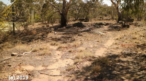
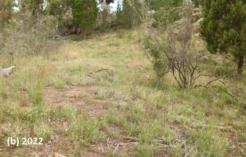
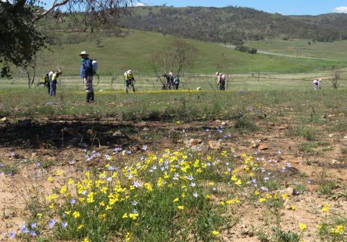
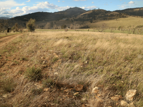
Figure 1. One of the many ‘before and after’ photo pairs showing how, (a) at the start of the project in 2019, a near-monoculture of African Love Grass was persisting even during the drought – but (b) native regeneration boomed after two seasons of good rain and regular spot-spraying of the prolific and diverse weed that regenerated along with the natives.

Introduction. Assisted regeneration works have been undertaken over three seasons at a small (4ha) but uncleared privately owned bush block on the urban boundary of Cooma in the southern tablelands of NSW. Degradation at the start of the project in 2019 reflected past land uses. Flatter areas disturbed by historic light sheep grazing and vehicular tracks appeared in poor condition, with infestations of serious weed, particularly bird spread shrubs and pasture weeds. Drought-induced dieback occurred across the site, along with evidence of overgrazing by macropods and rabbits. Most of the site’s extensive (lichen and moss-covered) granite rocky knolls, however, remained undisturbed and in good condition.

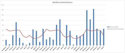
Results of the works were expected to be gradual, given that the area’s annual average rainfall was around 538 mm and growing seasons short due to the southern tablelands’ relatively cold climate. While these lower expectations were reasonable, they did not factor in the above average rainfall of the 2021-21 season and, particularly, the very high and evenly distributed rainfall of the 2021-22 growing season.

Vegetation community. The main vegetation association on the site (and the Reserve) is Ribbon Gum (Eucalyptus viminalis)-E Black Cypress Pine (Callitris endlicheri) grassy woodland, with co-dominant trees including Candlebark (E. rubida), Apple Box (E. bridgesiana), Broad-leaved Peppermint (E. dives) and Mountain Gum (E. dalympleana). Sweet Bursaria (Bursaria spinosa), Red-stemmed Wattle (Acacia rubida) and Woolly Grevillea (Grevillea lanigera) are common in the mid-storey, along with six Fabaceae shrubs. Out of the 88 native vascular plant species, 63 are herbaceous (15 grass species and 48 forb species including 13 Asteraceae) species.

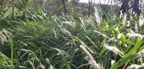
Weeds. At least 40 weed species occur on site, falling into two groupings – shrubs and groundcovers. The most prevalent shrubs were Orange Firethorn (Pyrocantha spp.) and Cotoneaster (Cotoneaster spp.) The most prevalent groundcovers were African Love Grass (Eragrostis curvula), Yellow Catsear (Hypochaeris radicata), Smooth Catsear (Hypochaeris glabra), St Johns Wort (Hypericum perforatum), Hare’s Foot Clover (Trifolium arvense), Proliferous pink (Petrorhagia nanteuilii) and Fleabane (Conyza sp.).

Works undertaken. Works have focused on the systematic and careful spot-spraying of individual weeds, rigorously following up to avoid the weed recharging soil seed banks. Cut brush was also laid down in a brickwork pattern along the contours to retain waterflow (where erosion was an issue) or deter macropods (where overgrazing was an issue, see https://youtu.be/4hmLFSL_kHQ ).

At the commencement of the works, ‘before’ photos were taken from eight pegged photopoints and at least 10 other informal ‘before’ shots across a wider range of subsites. Condition class mapping was undertaken using a 5-scale system adapted from the system used by the NSW National Trust since the 1980s.

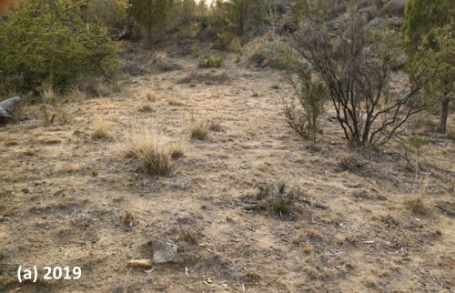
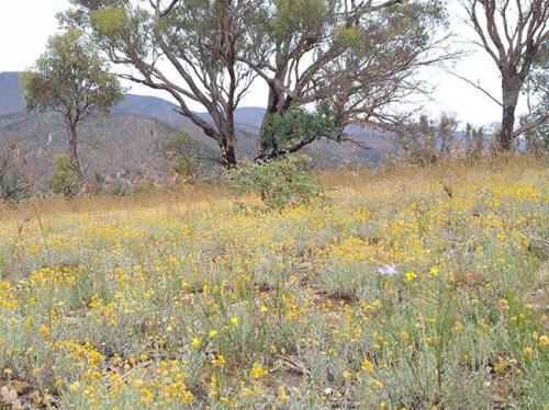
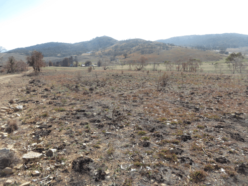
Figure 3. (a) Before and (b) after treatment at the ‘Rabbit flat’ subsite. This area was highly drought affected and overgrazed by kangaroos and rabbits in 2019. Weed trimmings were laid on the site to reduce sheet erosion and grazing. Weeds were regularly controlled, particularly African Love Grass and Hare’s Foot Clover. Drought breaking rains triggered germination of mainly Golden Everlasting (Chrysocephalum apiculatum), New Holland Daisy (Vittadinea cuneata) and range of other natives. Very little African Love Grass and other weeds now persist at this site.

Weed treatments (totalling approx. 250 hours) were carried out over three growing seasons (Spring- Autumn) starting in December 2019 and extending till May 2022 (Table 1). By far the most hours (237) were directed to precision knapsack spot-spraying of groundcover weeds, with relatively few hours treating shrub weeds. The highest input was required in the third season, due to its exceptionally favourable rainfall (Fig. 2) when we needed to increase our inputs to treat all herbaceous weed across the whole site prior to their setting seed and recharging seed banks.

Table 1.  Hours involved in spot-spraying of groundcover weed for each of the three seasons.

Season 1  (2019-20) Season 2(2020-21) Season 3(2019-20)
77 56

Figure 2. Rainfall records at the site over three growing seasons from December 2019 to May 2022 (Blue bars is rainfall recorded at East St, Cooma; the red line the mean rainfall recorded at the Cooma Visitor’s Centre).

Outcomes to date. While the site is far from fully recovered and works will be ongoing, results to date are encouraging. Figures 1 and 3 are three of many before and after photo pairs that compare the condition of all subsites prior to work with native plant recovery by January 2022 –24 months after the first drought-breaking rains. (Also see multiple photos at https://youtu.be/wjNviPl-MqY .) The condition classifications prior to works and at 3 seasons after works are shown in Figure 4.

In general most sites appear to have moved up in condition by at least one class; there is now substantially more area of medium to high condition after treatment compared to prior to treatment. However this result is still somewhat uncertain as the degree to which some of the Hare’s-foot Clover may have matured prior to spraying is unclear. The test of condition will be in Spring during the next above-average rainfall year.


Figure 4. Condition mapping (a) before and (b) after 3 seasons using a five-level condition classification system. The two maps show an increase in area of the green end of the spectrum (higher condition) and a reduction in area at the red end of the spectrum (lower condition). [The colour-coding and criteria are based on a four-level system used traditionally in the bush regeneration industry developed by the National Trust in the 1970s then modified during the 1990s by T. McDonald and subsequently resequenced to align with the 1-5 sequencing used in the 5-star system of the National Restoration Standards.]

Lessons learned and future directions.  The resilience level of this cold-climate, drought-affected plant community proved to be surprisingly high and growth relatively rapid after highly favourable rainfall. This may indeed be due to the species’ adaptation to periodic drought and short growing seasons.  Importantly (as elsewhere) such resilience also lends a capacity for natives to recover after periods of weed domination if that weed is removed.

It is logical to view the pattern of drought followed by highly favourable rainfall as somewhat similar to wildfire followed by highly favourable rainfall.  In such circumstances there is benefit in systematically treating as large an area as possible to (i) take advantage of the opportunities for rapid recovery of natives and (ii)  avoid massive and unusual recharge of weed seedbanks that could set a site’s condition back by many decades. While the landholders in this case did the work themselves and could increase or decrease work as required per season, cases relying on public funding would benefit from contingency funding being set aside for supporting additional restoration inputs in high rainfall seasons post-fire or post-drought.

Stakeholders.  The works were carried out by the block’s landholders Tein McDonald and Graeme Little.   Friends of Grassland helped with plant identification and encouragement and provided a small grant  to offset the costs of herbicide and equipment.

Contact:  Tein McDonald teinm@ozemail.com.au


Post-fire assisted regeneration at Rutidosis Ridge, Scottsdale Reserve, Bredbo NSW


Figure 1. Undamaged grassy woodland reference site occurring at high elevation at Scottsdale (Photo: Brett Howland)

Introduction. Scottsdale Reserve is a 1,328-hectare private conservation reserve, near Bredbo NSW, owned and managed by Bush Heritage Australia. For over 100 years prior to purchase in 2006 the property was utilised for grazing and cropping. While most of the higher elevation areas of the property remained intact and offered the basis for improving landscape connectivity for wildlife, the agricultural land use had resulted in conversion of the flats and lower slopes of the property to largely exotic pasture species and accompanying weed.

This case study focuses on one approx 10 ha Apple Box (Eucalyptus bridgesiana) / Snow Gum, (Eucalyptus pauciflora) grassy woodland ridge within the property – named ‘Rutidosis Ridge’ because it is the location of a small population of the Endangered plant species Button Wrinklewort (Rutidosis leptorhynchoides). Set-grazing by sheep as well as some cropping had left the site nearly wholly dominated by the landscape-transforming exotic pasture grasses African Love Grass (Eragrostis curvula) and Serrated Tussock (Nasella tricotoma). Some scattered copses of eucalypts and some herbaceous natives remained, however, suggesting that the site might have some native regeneration potential, but the number and abundance of natives on the site appeared very low and the site was very dissimilar to a nearby healthy reference site (Fig. 1).

Works undertaken. Around a decade after land purchase and the discontinuation of grazing and cropping, Rutidosis Ridge was aerially sprayed during winter with flupropinate herbicide at a low dilution (1L / ha) known to be effective on some strains of African Love Grass and Serrated Tussock without killing native grasses and forbs. While the African Love Grass and Serrated Tussock had died by the following spring as a result of this soil-active herbicide, no substantial native regeneration was observed due to the persistence of the thick thatch of dead African Love Grass (Fig 2).

  • Figure 2.  Typical site showing sprayed African Love Grass thatch even many years after aerial spraying. (Photo T. McDonald )
  • Figure 3.  Intense wildfire that passed through Bredbo, NSW in early February. (Photo” New York Times)

An intense wildfire passed through the property on 2nd February 2020 (Fig. 3). This largely consumed the thatch, exposing stony topsoils and providing opportunities for regeneration of both natives and weeds that were stored in the soil seed bank.  Anticipating the need for post-fire spot-spray follow-up after the fire to avoid any native regeneration being overwhelmed by weed, Bush Heritage Australia (BHA) collaborated on a program of regular selective treatment of weed with the restoration organisation the Australian Association of Bush Regenerators (AABR). Personnel involved both contractors and volunteers skilled in recognising natives and weeds at seedling stage capable of spot-spraying with negligible off-target damage (Fig 4).  

Because the fire had removed African Love Grass thatch and cued germination of natives and weeds, the aim was to treat all weed prior to its seeding.  This allowed the managers to (a) take advantage of the fire’s flushing out the weed soil seed bank and avoid its further recharge and (b) retain maximum open spaces for further natives to emerge and colonise. 

During the year after the fire (March 2020-April 2021), the ~10ha site had been subjected to approx. 600 person hours of spot spraying, mainly undertaken by experienced bush regenerators. This commenced in March 2000 and continued at least fortnightly during the growing season.

Figure 4. Location of comprehensively spot-sprayed areas and target-weeded areas at Rutidosis Ridge. An opportunity exists to compare differences in richness and cover of natives and weed between the two treatments, ensuring comparisons are confined to within-comparable condition classes.

What we found by 1 year of treatments.  Post-fire observations in  March 2020 revealed Snow Gum resprouting from lignotubers and roots and Apple Box and Candlebark (Eucalyptus rubida) resprouting epicormically.  A wide suite of native grasses and forbs were starting to resprout or germinate alongside diverse herbaceous weeds. Within the first 12 months of regular spot-spraying, the cover and seed production of approx. 30 weed species was very substantially reduced.  Combined with fairly evenly distributed rainfall in the follow 12 months this reduction in weed allowed ongoing increases in native species cover and diversity per unit area, with seed production likely by most native species.  There was negligible off-target damage from the spray treatments. In December 2020 over 50 native herbaceous and sub-shrub species (including at least 11 Asteraceae, 9 Poaceae, 4 Fabaceae and 2 Liliaceae) were recorded within the work zones, with cover of natives very high in the higher condition zones, but plentiful bare ground remaining in the lower condition zones (Fig. 5).  

Figure 5.  Top:  Directly after wildfire showing black stubs of African Love Grass; Middle: Volunteers spot-spraying during the growing season, and Bottom: same site after 12 months but when native grasses were curing off after seeding. (Photos T. McDonald)

Predominant weed species included recovery African Love Grass, Viper’s Bugloss (Echium vulgare), St John’s Wort (Hypericum perforatum), Yellow Catsear (Hypochoeris radicata), Common Plantain (Plantago major), a range of thistles and around 20 other weed species.

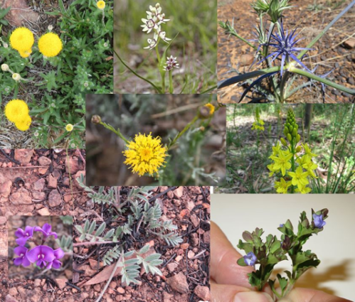
Predominant natives included speargrasses (Austrostipa spp.), Redleg Grass (Bothriochloa macrantha), Kangaroo Grass (Themeda triandra), Native Panic (Panicum effusum), Common Raspwort (Gonocarpus teucrioides), Bindweed (Convolvulus erubescens), bluebells (Wahlenbergia spp.), Common Everlasting (Chrysocephalum apiculatum), fuzzweeds (Vitadennia spp.), Bear’s Ear (Cymbonotus lawsonianus), Creamy Candles (Stackhousia monogyna), Yellow Pimelea (Pimelea curviflora subsp. fusiformis) and Native St John’s Wort (Hypericum gramineum).  Species of higher conservation interest that regenerated included Blue Devil (Eryngium ovinum) and Threatened species that regenerated included Silky Swainson’s Pea (Swainsona sericea) and Button Wrinklewort. (Some of these species are pictured in Fig. 6).

Figure 6. Some of the forbs that flowered on Rutidosis Ridge during the growing season – including the Endangered Button Wrinklework (centre) and Vulnerable Silky Swainson’s Pea.(bottom left). (Photos various.)

Gradient of condition improving over time. As expected, the sites showed a gradient of condition (Fig. 7), with highest natural regeneration capacity retained in the tree clusters and stony crest, perhaps due to these less likely to be less favoured by sheep. (The tree clusters appear not to have been used as sheep camps). By March 2020, 1 year after work commenced, all sites were on a trajectory to move to the next higher condition class, assuming successful Winter 2021 aerial spray re-treatment of African Love Grass.  (Note that, while the pre-fire flupropinate treatment would normally have a residual effect for a few years and thus preventing germnation of this species, massive germination did occur of African Love Grass in many areas, which we speculate was either due to suitable post-fire germination conditions being delayed by the presence of dead grass thatch or to a possible denaturing of the chemical by the fire.)  

Figure 7. Condition classes in the Rutidosis Zones A-E revealed during the first few months of treatment. By the end of the growing season and after regular follow up spot-spraying it was clear that all zones comprehensively treated were improving in their native: weed cover ratio except for an increasing cover of African Love Grass, the treatment of which was deferred until a second aerial spray scheduled for winter 2021. (Map: T. McDonald)

Acknowledgements: This project would not have been possible without the help of BHA and AABR volunteers.

Contact: Tein McDonald and Phil Palmer, Scottsdale Tel: +61 (0) 447 860 613; Email: <teinm@ozemail.com.au and phil.palmer@bushheritage.org.au


Crowdy Bay National Park, NSW – Assisted regeneration of a littoral rainforest patch post 2019-20 summer wildfire

Figure 1. Volunteers at the initial working bee in the burnt littoral rainforest.

Introduction. Crowdy Bay National Park is located on the NSW Mid-north coast and comprises coastal landscapes, some of which have were sand mined prior to the area’s acquisition for conservation in the 1970s. Littoral rainforest remnant and regrowth patches occur within the Park and are listed at State level and as Endangered Ecological Community and at national level as a Threatened Ecological Community. The rainforest community type forms in the dune swales, protected by Coast Banksia (Banksia integrifolia) and is dominated over time by Tuckeroo ( Cupaniopsis anacardioides) and Beach Alectryon (Alectryon coriaceus), with other rainforest co-dominants and associated shrubs, vines and groundcovers.

For over four decades,  a regeneration program has been carried out in the park by volunteers working through the National Parks Association (NPA), Mid North Coast Branch. This short summary refers to the condition of one floristically diverse littoral rainforest patch at Kylie’s Beach, half of which was burnt in a spot-wildfire in late 2019 and in which weed managment works commenced 2 years prior to the wildfire due to pre-existing weed issues (Fig 1).

The wildfire and early recovery. The wildfire burnt all the banksias on the foredune crest that were providing wind protection for the littoral rainforest, as well as 1ha of the littoral rainforest. It left the ground layer beneath both areas largely bare. In the areas burnt, all trees appeared dead. With rainfall occurring soon after the fire, post-fire coppicing of rainforest trees and Banksia commenced; with germination of native seedlings occurring with the arrival of heavy rains in December 2020 -January 2021. By mid-autumn 2020 the northern foredune section was thickly covered with colonising Blady Grass (Imperata cylindrica) that provided cover for other successional natives (Fig 2) .

Weed recovery, however, was very rapid. As early as May 2020, the site was a sea of annuals, with abundant Lantana (Lantana camara), Coastal Morning Glory (Ipomoea cairica), Cape Gooseberry (Physalis peruviana), Crofton Weed (Ageratina adenophora) and scatterings of Cape Ivy (Senecio mikanioides) and Tobacco Bush (Solanum mauritianum). Volunteers were at a loss to see how the site could be helped to regenerate. Not having previously worked in a burnt rainforest, the first though was to take out all the weeds. Under the guidance of retired regenerator Tom Clarke from the Australian Association of Bush Regenerators (AABR) however, a different approach was taken.

Figure 2. Blady Grass has covered much of the floor.

Works undertaken. Commencing in May 2020 Sue Baker from NPA and Tom Clarke from AABR conducted monthly working bees to strategically remove weeds. The approach was to  regard the weeds as the new canopy cover and primary colonisers, providing invaluable shade and moisture retention for the regenerating rainforest species. It was agreed that the main initial objective was to see the re-establishment of a canopy, however low, to protect the ground moisture levels and any recovering herb layer. At this point any woody weeds were considered allies in that they were resprouting along with many native pioneer species. Treatment of woody weeds was selective and dependent upon direct competition with native plants. Instead, treatment of weed vines and creepers was targeted, with removal of Morning Glory and Cape Ivy a priority, at least to the edge of the burnt zone.

Subsequently, apart from preventing the spread of Cape Ivy and removing dense infestations of fruiting Cape Gooseberry, the method was to remove weeds only where they were competing with native seedlings with as much removal of their fruits and seeds as possible, followed by thinning out later where helpful. By January 2021, native ground cover had recovered sufficiently to remove the annuals, some of which were 2m high. Over time, the selective treatment of woody weeds has continued as more and more native regen appeared. By taking this approach we have left nature largely to do its own thing with minimal detrimental impact from weeding.

In addition, we have taken the view that the wildfire was not soley a negative; it has also provided an opportunity to address some of the long-standing weed issues in the broader area of Kylie’s Beach including that of Glory Lily (Gloriosa superba) and Golden Wreath Wattle (Acacia saligna) which the fire stimulated to germinate from the soil seed bank in their thousands.

As well as the weed management work, over a kilogram of native seed was broadcast in mid-summer 2020 in the hope it might improve recovery of the ecosystem.

Volunteer visits. After a site inspection tour on 14th May 2020 there have been at least 17 visits to Crowdy Bay National Park where regeneration works has been carried out, not only in the littoral rainforest, but also in the broader Kylie’s beach area. These occurred in May (1 visit), July (3 visits), August (4 visits involving 12 volunteers), September (2 visits), October (4 visits), November (1 visit) and lately in January 2021 (2 visits).

Figure 3. Tuckeroo coppicing from the burnt stump.

Figure 4. Lillypilly coppicing.

Results to date.  The site has demonstrated itself to have high levels of native resilience, having been in relatively healthy condition apart from per-existing weed infestations. High levels of rain in the 2020-21 summer has promoted extensive and vigorous growth. At February 2021, the forest floor was a carpet of native vegetation and some areas knee-high in dense native grasses. Less care in selecting woody weeds for treatment is now required.

Much of the regeneration is from germinating seeds but some has been from re-sprouting rootstocks, resprouting stems or coppicing from the bases of trees, including rainforest trees (Figs 3 and 4) although some large trees are dead  (See Table 1). With the assisted regeneration work (i.e. strategic weed removal post-fire) the site is quickly shifting from a predominantly weed-dominated post-fire succession to one dominated by native plants.

There is no evidence that the sown seed has yet contributed to the regeneration at this stage.  Native regeneration was occurring across the area prior to the date when germination of sown seed would be expected and it is now clear that additional seed was not required.

Plans for ongoing management.  The continued wet and humid conditions in summer 2021 have provided highly favorable conditions for regeneration. During 2021 the volunteers will try to keep up with the work at Kylie’s Beach through regular bush regeneration camp outs (as organised for many years, except 2020 which was cancelled due to COVID-19 restrictions). Work plans for the next camp-out have been scheduled to include the Kylie’s Beach littoral rainforest site and will include follow-up treatment of vines and Crofton Weed. Full recovery is likely to take years as the recovery process moves at its own pace.

Two major issues remain – dense ground and canopy cover of coastal morning glory in the area will need meticulous treatment. Also an entire drainage line on the steep, rocky cliff face behind the dune is densely infested with Crofton Weed that must be left in place to stabilize the slope until sufficient native cover takes hold. Volunteers were able to remove flowers from the Crofton Weed for a certain distance up the slope. Contractors will be needed in 2021 to deal with the upper slope.

Acknowledgements: We thank the organisation and leadership of NPA group.  The fact that this was already in place prior to the fire, was a key to the success of the work to date. This group has an outstanding history and connection with many sites in the Park over many years. The linking of AABR to the project provided additional support in project design and facilitating additional volunteer from the ABBR network for the post-fire restoration side of the program.

Contacts:  Tom Clarke AABR 0418411785 and Sue Baker (NPA MNC branch)

Table 1. Kylie’s Beach Littoral Rainforest Post Fire Restoration  – responses of native and exotic species (Exotics marked with an asterisk)

Scientific name Common name Response of the species at this site Notes
Grasses
Imperata cylindrica Blady Grass Resprouted Dominating burnt floor devoid of canopy
Oplismenus aemulus Basket Grass Resprouted and germinated Near edge of existing canopy
Ehrharta erecta* Panic Veldtgrass Germinated Hillside on open ground near crofton weed
Eriochloa procera Spring Grass Germinated Near edge of existing canopy
Scramblers and Climbers
Marsdenia flavescens Hairy Milk Vine Resprouted and germinated At edge of existing canopy
Senecio mikanioides* Cape Ivy Resprouted Remnants creeping through grasses, has been heavily targeted.
Ipomoea cairica* Mile-a-minute Resprouted and germinated Existing condition taking advantage, targeted for weeding
Desmodium sp. (varians?) Desmodium Germinated Carpeting over slope to dune swale
Glycine sp. (tabacina?) Love Creeper Germinated Carpeting over slope to dune swale
Sarcopetalum harveyanum Pearl Vine Resprouted and germinated Near edge of existing canopy.
Stephania japonica Snake Vine Resprouted and germinated Near edge of existing canopy or large remnant structures
Dioscorea transversa Native Yam Resprouted Near edge of existing canopy or large remnant structures
Passiflora edulis* Blue Passion Flower Resprouted and germinated Single isolated plant. Previously overlooked?
Rubus parvifolius Native Raspberry Resprouted and germinated Creeping through rank grasses
Cayratia clematidea Slender Grape Resprouted and germinated Creeping through rank grasses
Cissus antarctica Kangaroo Grape Resprouted Mostly at edge of existing canopy.
Tetrastigma nitens Three-leaved Water Vine Resprouted Near edge of existing canopy
Flagellaria indica Whip Vine Resprouted Isolated individuals searching for structure
Geitonoplesium cymosum Scrambling Lily Resprouted Creeping through rank grasses
Smilax australis Austral Sarspariila Resprouted Moving into grass floor plus climbing burnt structures.
Ground Covers and Herbs
Hydrocotle bonariensis* Pennywort Resprouted Associated with commelina in low swale
Commelina cyanea Scurvy Weed Resprouted Feature of low swale within open floor area; also underneath grasses.
Melanthera biflora Melanthera Resprouted Carpeting top of rise from dune swale
Tufted Plants
Crinum pedunculatum Swamp Lily Resprouted Seaward edge to dune swale
Dianella congesta Coastal Flax Lily
Lomandra longifolia Mat Rush Resprouted and germinated Isolated individuals, seedlings and survivors
Ficinia nodosa Knobby Club-sedge Resprouted Seaward side pushing up from dune swale below
Cyperus sp. (sanguinolentus?) Sedge Resprouted Associated with commelina etc in swale near False Bracken
Alocasia brisbanensis Cunjevoi Resprouted Scattered near edge of existing canopy or structures.
Ferns
Doodia aspera Rasp Fern Resprouted Mostly near edges of existing canopy
Pellaea falcata Sickle Fern Resprouted Mostly with grass at edge of existing canopy
Calochlaena dubia False Bracken Fern Resprouted Dense patches on floor adjacent to Blady Grass
Dicksonia antarctica Treefern Resprouted Unaffected individuals near edges
Shrubs
Acacia longifolia (var. sophorae?) Golden Wattle Germinated Seedling growth mostly seaward edge of floor.
Breynia oblongifolia Coffee Bush Germinated Isolated individuals from seedlings
Banksia integrifolia Coastal Banksia Resprouted and germinated Coppicing from burnt stumps plus seedlings
Physalis peruviana* Cape Gooseberry Rampant pioneer exotic targeted for weeding
Solanum nigrum* Blackberry Nightshade Germinated Rampant pioneer exotic targeted for weeding
Lantana camara* Lantana Resprouted Rampant pioneer exotic targeted for weeding
Poyscias elegans Celerywood Germinated Scattered seedlings
Trema tomentosa var. viridis Native Peach Germinated Pioneer from seedlings; competing well
Conyza sumatrensis* Tall Fleabane Germinated Rampant pioneer exotic targeted for weeding
Notelea venosa? Mock Olive Resprouted Coppicing from burnt stump.
Bidens Pilosa* Cobbler’s Pegs Germinated Rampant pioneer exotic targeted for weeding
Phytolacca octandra* Inkweed Germinated Isolated patches
Ageratina Adenophora* Crofton Weed Resprouted and germinated?? Isolated patches on floor plus large, dense infestation covering hillside soak
Chrysanthemoides monilifera* Bitou Bush Resprouted and germinated Isolated individual plants
Trees
Cupaniopsis anacardioides Tuckeroo Resprouted and germinated Coppicing from burnt stumps plus seedlings
Wilkiea huegeliana Wilkiea Resprouted Coppicing from burnt stumps
Homalanthus populifolius Bleeding Heart Germinated Pioneer from seedlings; competing well
Alectryon coriaceus Beach Tamarind Resprouted Coppicing from burnt stumps.
Solanum mauritianum* Tree Tobacco Germinated Pioneer exotic targeted for weeding
Ficus rubiginosa Port Jackson Fig Resprouted Coppicing from burnt stumps
Laurel type Coppicing from burnt stumps
Synoum glandulosum Scentless Rosewood Resprouted Coppicing from burnt stumps

More than just a Long Paddock: Fostering native vegetation recovery in Riverina Travelling Stock Routes and Reserves – UPDATE of EMR feature

Ian Davidson

[Update of EMR feature – Davidson, Ian and Peter O’Shannassy (2017) More than just a Long Paddock: Fostering native vegetation recovery in Riverina Travelling Stock Routes and Reserves. Ecological Management & Restoration, 18:1, 4-14.  https://onlinelibrary.wiley.com/doi/10.1111/emr.12247]

Roger Harris with direct seeded shrubs –  Rand TSR. (Photo Ian Davidson)

Introduction.  As described in our 2017 EMR feature, the Enriching biodiversity in the NSW Riverina project was a five-year project funded by the Federal Government’s Carbon Farming initiative and managed by Murray Local Land Services (LLS). The project aimed to maintain the condition of the highest quality TSRs and improve the condition of 10% of all other TSRs, some of which had been receiving degrees of grazing management for many decades to optimize resilient native pastures (Refer to our earlier 2005, EMR feature). Given the NSW Riverina TSR network contains over 600 reserves, a sample was first selected for inspection to identify reserves with the potential for further active management. This led to the implementation of recommended land management and works on 109 reserves covering 13,558 ha and the subsequent monitoring of those reserves. Results indicated that, of these reserves, 70 had improved in vegetation condition by 2017. This project proved that large scale protection and improvement of TSR condition was possible using existing staff and provided valuable lessons that could be applied elsewhere across the state.

Table 1 Summary of key lessons learnt from the project and recommendations for effective TSR management

Human resources ·       Use existing knowledge where available

·       Maintain continuity of leadership

Assessment and

monitoring

·       Establish broadly applicable and consistent assessment and monitoring criteria

·       Use methods which are easily understood

·       Consider seasonal effects on the timing of surveys

·       Recommended actions should be appropriate for the site condition

Project Scale ·       Larger project areas and longer project timelines increase the rate of success

·       Regular monitoring avoids major problems

Revegetation ·       Seed banks are vital to achieving large scale revegetation

·       Multiple species should be used in direct seeding

·       Exotic grasses should be controlled prior to direct seeding

·       Native species can assist in spreading shrubs over time

Land Management ·       Controlling herbivores is critical during early growth stages

·       Grazing indicators/surrogates are useful

·       Stock type impacts grazing style

·       Cattle can graze areas with shrub seedling germination under certain conditions

·       Fencing and water points offer flexibility in managing stock for regeneration

·       Noisy Miners reduce small woodland bird numbers and they are difficult to control

Unplanned Impacts ·       Human intervention in unpredictable Natural events can lead to major changes in land management focus

Stuart Watson monitoring vegetation at Narrow Plains TSR. (Photo Ian Davidson)

Subsequent developments. Since the publication of our 2017 feature ‘More than just a Long Paddock: Fostering native vegetation recovery in Riverina Travelling Stock Routes and Reserves’ the following five key developments regarding nature conservation on TSRs in NSW have occurred.

  1. Developing and applying a simple field based consistent method for assessing and monitoring vegetation condition across the TSR network – A new rapid assessment and monitoring method was developed and trialed in this project for use by land managers with limited botanical and scientific skills and limited time. This field-based method known as Rapid Conservation Assessment Method (RAM) proved useful and has the potential for broader adoption across NSW. For detailed information refer to https://www.lls.nsw.gov.au/livestock/stock-routes/conservation-of-tsrs
  2. Categorizing the conservation status using an agreed method of TSRs across NSW – Using the RAM to complete assessments and collating all previously assessed TSR reports, LLS developed a consistent statewide map of the conservation status for the 534,000ha under their control (refer to https://www.lls.nsw.gov.au/livestock/stock-routes/conservation-of-tsr). This enabled LLS, the statewide land manager, to better understand the overall vegetation condition, extent and distribution of their TSR assets from a nature conservation perspective.
  3. Developing a Best environmental management practice (BeMP) Toolkit for TSRs to ensure good long-term conservation objectives – Key knowledge learnt from the Riverina project, LLS ranger’s knowledge and experience and existing literature influenced the development of the NSW Travelling Stock Reserves State Planning Framework 2016–21 (the Framework), which provides the framework for managing TSRs for conservation. A Best Environmental Management Practice (BeMP) toolkit was also prepared from this collation of knowledge to assist LLS deliver land management outcomes (including grazing, apiary, native seed collection, emergency response/refuge for livestock, threatened ecological communities and species, revegetation on TSRs, weed control, pest animal control, soil disturbance and drainage changes) consistent with the Framework. The BeMP is currently in draft form.
  4. Developing a statewide plan of management (PoM) for TSRs to ensure consistency across administrative boundaries – The NSW government is finalizing the details of a PoM which provides LLS staff, TSR stakeholders, investors, partners and customers with our shared vision and common mission. It sets out agreed strategies, approaches, principles and quality system to better manage the reserves. This PoM aims to improve social, economic, environmental and cultural outcomes while maintaining grazing as an important economic use and conservation tool. Importantly this plan establishes the need for shared responsibility and collaborative funding. For more information refer to https://www.lls.nsw.gov.au/__data/assets/pdf_file/0005/839930/NOV-TSR-PoM-MOedits-1.pdf
  5. Attracting significant investment to assist with protection and maintenance of TSR environmental values – LLS the managers of NSW TSRs receive no recurrent funding from government for the environmental management of the TSR estate and therefore have been dependent upon the proceeds from permits and leases e.g. grazing and annual grants e.g. weed and pest animal control to maintain the condition of TSRs. Now however, based on the PoM and guided by environmental management and works consistent with best environmental management practice, the LLS is negotiating with a government investor to fund agreed long term maintenance and enhancement of selected high and moderate conservation value TSRs.

Peter O’Shannassy with direct seeded shrubs on Snake Island TSR. (Photo Ian Davidson)

Lessons learned. Together, the five developments above show how the large-scale restoration project reported in 2017 has been further developed as a model for TSR protection and restoration across NSW, enabling buy-in by LLS to better manage these invaluable natural resource assets across NSW.

Acknowledgements. LLS staff Peter O’Shannassy steered most aspects of the project from its inception, whilst Stuart Watson and Roger Harris managed most of the on-ground management and works and lately Gary Rodda the Murray General Manager who has overseen the statewide development of the PoM. Lastly, I dedicate my TSR work to my great mate Rick Webster who was lost to us recently and with whom I shared a deep, long standing curiosity and love of these special areas.

Contact.  Ian Davidson (for technical matters) ian@regenerationsolutions.com.au  or  Peter O’Shannassy  (for land management and operational matters) peter.o’shannassy@lls.nsw.gov.au


Ku-ring-gai Flying-fox Reserve Habitat Restoration Project at Gordon, 2000 – 2019 UPDATE of EMR feature

Nancy Pallin

[Update to EMR feature –  Pallin, Nancy (2001) Ku-ring-gai Flying-fox Reserve Habitat restoration project, 15 years on.  Ecological Management & Restoration 1:1, 10-20. https://onlinelibrary.wiley.com/doi/10.1046/j.1442-8903.2000.00003.x]

Key words:         bush regeneration, community engagement, wallaby browsing, heat events, climate change

Figure 1. Habitat restoration areas at Ku-ring-gai Flying-fox Reserve within the urban area of Gordon, showing areas treated during the various phases of the project. Post-2000 works included follow up in all zones, the new acquisition area, the pile burn site, the ecological hot burn site and sites where vines have been targeted. (Map provided by Ku-ring-gai Council.)

Introduction. The aim of this habitat restoration project remains to provide self-perpetuating indigenous roosting habitat for Grey-headed Flying-fox (Pteropus poliocephalus) located at Ku-ring-gai Flying-fox Reserve in Gordon, NSW Australia (Fig 1).  The secondary aim was to retain the diversity of fauna and flora within the Flying-fox Reserve managed by Ku-ring-gai Council. Prior to works, weed vines and the activity of flying-foxes in the trees had damaged the canopy trees while dense weed beneath prevented germination and growth of replacement trees.  Without intervention the forest was unable to recover.  Natural regeneration was assisted by works carried out by Bushcare volunteers and Council’s contract bush regeneration team.  The work involved weed removal, pile burns and planting of additional canopy trees including Sydney Bluegum (Eucalyptus saligna), which was expected to cope better with the increased nutrients brought in by flying-foxes.

Figure 2. The changing extent of the Grey-headed Flying-fox camp from the start of the project, including updates since 2000. (Data provided by KBCS and Ku-ring-gai Council)

Significant changes have occurred for flying-foxes and in the Reserve in the last 20 years.

In 2001 Grey-headed Flying-fox was added to the threatened species lists, of both NSW and Commonwealth legislation, in the Vulnerable category.  Monthly monitoring of the number of flying-foxes occupying the Reserve  has continued monthly since 1994 and, along with mapping of the extent of the camp, is recorded on Ku-ring-gai Council’s Geographical Information System. Quarterly population estimates contribute to the National Monitoring Program to estimate the population of Grey-headed Flying-fox.  In terms of results of the monitoring, the trend in the fly-out counts at Gordon shows a slight decline.  Since the extreme weather event in 2010, more camps have formed in the Sydney basin in response to declining food resources.

In 2007, prompted by Ku-ring-gai Bat Conservation Society (KBCS), the size of the Reserve was increased by 4.3 ha by NSW Government acquisition and transfer to Council of privately owned bushland. The Voluntary Conservation Agreement that had previously established over the whole reserve in 1998 was then extended to cover the new area.   These conservation measures have avoided new development projecting into the valley.

From 2009 Grey-headed Flying-fox again shifted their camp northwards into a narrow gully between houses (Fig 2).  This led to human-wildlife conflict over noise and smell especially during the mating season. Council responded by updating the Reserve Management Plan to increase focus on the needs of adjoining residents.  Council removed and trimmed some trees which were very close to houses. In 2018 the NSW Government, through Local Governments, provided grants for home retrofitting such as double glazing, to help residents live more comfortably near flying-fox camps.

Heat stress has caused flying-fox deaths in the Reserve on five days since 2002. Deaths (358) recorded in 2013, almost all were juveniles of that year.  KBCS installed a weather station (Davis Instruments Vantage Pro Plus, connected through a Davis Vantage Connect 3G system) and data loggers to provide continuous recording of temperature and humidity within the camp and along Stoney Creek.  The station updates every 15 minutes and gives accurate information on conditions actually being experienced in the camp by the flying-foxes. The data is publicly available http://sydneybats.org.au/ku-ring-gai-flying-fox-reserve/weather-in-the-reserve/Following advice on the location and area of flying-fox roosting habitat and refuge areas on days of extremely high temperatures (Fig 3.) by specialist biologist Dr Peggy Eby, Council adopted the Ku-ring-gai Flying-fox Reserve 10 Year Management and Roosting Habitat Plan in 2018.  Restoration efforts are now focused on improving habitat along the lower valley slopes to encourage flying-foxes to move away from residential property and to increase their resilience to heat events which are predicted to increase with climate change.

Figure 3. Map showing the general distribution of flying-foxes during heat events, as well as the location of exclosures. (Map provided by Ku-ring-gai Council)

Further works undertaken.  By 2000 native ground covers and shrubs were replacing the weeds that had been removed by the regeneration teams and Bushcare volunteers.  However, from 2004, browsing by the Swamp Wallaby (Wallabia bicolor) was preventing growth of young trees and shrubs.  Bushcare volunteers, supported by KBCS and Council responded by building tree cages made from plastic-mesh and wooden stakes. Reinforcing-steel rods replaced wooden stakes in 2008.   From 2011, the Bushcare volunteers experimented with building wallaby exclosures, to allow patches of shrubs and groundcovers to recover between trees (Figs 3 and 4).  Nineteen wallaby exclosures have been built. These range in size from 7m2 to 225m2 with a total area of 846m2.   Wire fencing panels (Mallee Mesh Sapling Guard 1200 x 1500mm) replaced plastic mesh in 2018.  Silt fence is used on the lower 0.5m to prevent reptiles being trapped and horizontally to deter Brush Turkey (‎Alectura lathami) from digging under the fence.

The wallaby exclosures have also provided an opportunity to improve moisture retention at ground level to help protect the Grey-headed Flying-fox during heat events.  While weed is controlled in the exclosures south of Stoney Creek, those north of the creek retain Trad and privets, consistent with the 10 Year Management and Roosting Habitat Plan.

Madeira Vine (Anredera cordifolia) remained a threat to canopy trees along Stoney Creek for some years after 2000, despite early treatments.  The contract bush regen team employed sInce 2010 targeted 21 Madiera Vine incursions.

A very hot ecological burn was undertaken in 2017 by Council in order to stimulate germination of soil stored seed and regenerate the Plant Community Type (PCT) – Smooth-barked Apple-Turpentine-Blackbutt tall open forest on enriched sandstone slopes and gullies of the Sydney region (PCT 1841).  This area was subsequently fenced. The contract bush regeneration team was also employed for this work to maintain and monitor the regeneration in the eco-burn area (720 hours per year for both the fire and Madiera Vine combined).

Figure 4. Exclusion fence construction method. Pictured are Bushcare volunteers, Jill Green and Pierre Vignal. (Photo N Pallin).

Figure 5. Natural regeneration in 2018 in (unburnt) exclosure S-6 (including germination of Turpentines). (Photo N. Pallin)

Further results to date. The original canopy trees in Phase 1 and Phase 2 (1987 -1997) areas have recovered and canopy gaps are now mostly closed. Circumference at breast height measurements were taken for seven planted Sydney Blue gum trees.  These ranged from 710 to 1410mm with estimated canopy spread from 2 to 6m.  While original Turpentine (Syncarpia glomulifera) had circumferences from 1070 and 2350mm with canopy spread estimated between 5and 8m, those planted or naturally germinated now have circumference measurements between 420 and 980mm with canopy spread estimated from 1.5 to 3m.  A Red Ash (Alphitonia excelsa) which naturally germinated after initial clearing of weeds now has a circumference of 1250mm with a canopy spread of 5m.  Also three Pigeonberry Ash (Elaeocarpus kirtonii) have circumference from 265 to 405mm with small canopies of 1 to 2m as they are under the canopies of large, old Turpentines.  As predicted by Robin Buchanan in 1985 few Blackbutt (Eucalyptus pilularis) juveniles survived while the original large old trees have recovered and the Sydney Bluegum trees have thrived.

In the Phase 3 (1998 – 2000) area south of Stoney Creek the planted Sydney Blue Gum now have circumferences measuring between 368 and 743 (n7) with canopy spread between 2 and 6 m.  in this area the original large trees have girths between 1125 and 1770mm (n7) whereas trees which either germinated naturally or were planted now range from 130 to 678mm (n12).  These measurement samples show that it takes many decades for trees to reach their full size and be able to support a flying-fox camp.

Wallaby exclosures constructed since 2013 south of Stoney Creek contain both planted and regenerated species.  Eight tree species, 11 midstorey species, 27 understorey species and eight vines have naturally regenerated.  Turpentines grew slowly, reaching 1.5m in 4 years.  Blackbutts thrived initially but have since died. In exclosures north of the creek,  weeds including Large-leaved Privet,  Ligustrum lucidum,  Small-leaved privet,  L. sinense,  Lantana, Lantana camara,  and Trad, Tradescantia fluminensis) have been allow to persist and develop to maximise ground moisture levels for flying-foxes during heat events. Outside the exclosures, as wallabies have grazed and browsed natives, the forest has gradually lost its lower structural layers, a difference very evident in Fig 6.

Figure 6. Visible difference in density and height of ground cover north and south of Stoney creek. (Photo P. Vignal)

Coachwood (Ceratopetalum apetalum) were densely planted in a 3 x 15m exclosure under the canopies of mature Coachwood next to Stoney Creek in 2015. In 4 years they have reached 1.5m.  In this moist site native groundcovers are developing a dense, moist ground cover.

Madiera Vine, the highest-threat weed, is now largely confined to degraded edges of the reserve, where strategic consolidation is being implemented with a view to total eradication.

In the hot burn area, which was both fenced and weeded, recruitment has been outstanding. One 20 x 20m quadrat recorded 58 native species regenerating where previously 16 main weed species and only 6 native species were present above ground. A total of 20 saplings and 43 seedlings of canopy species including Eucalyptus spp., Turpentine and Coachwood were recorded in this quadrat where the treatment involved weed removal, burning and fencing  (S. Brown, Ku-ring-gai Council, July 2019, unpublished data).  Unfortunately, however, the timing and location of the burn did not take into account its impact on the flying-fox camp and there was some damage to existing canopy trees. It will be many years before the canopy trees, which are regenerating, will be strong enough to support flying-foxes.

Monitoring from the weather station and data loggers has shown that close to Stoney Creek on a hot day it is typically 2-3° C cooler, and 5-10% higher in humidity, than in the current camp area (pers. comm. Tim Pearson). During heat events the flying-foxes move to this cooler and moister zone, increasing their chances of survival.

Fauna observed other than flying-foxes includes a pair of Wedge-tail Eagle ( Aquila audax plus their juvenile, a nesting Grey Goshawk (Accipiter novaehollandiae) and a Pacific Baza (Aviceda subcristata).  Powerful Owl (Ninox strenua) individuals continue to use the valley. The presence of raptors and owls indicate that the ecosystem processes appear to be functional. Despite the decline of the shrub layer outside fenced areas, the same range of small bird species (as seen prior to 2000) are still seen including migrants such as Rufous Fantail ( Rhipidura rufifrons) which prefers dense, shady vegetation. The first sighting of a Noisy Pitta (Pitta versicolor) was in 2014.  Long-nosed Bandicoot (Perameles nasuta) individuals appear and disappear, while Swamp Wallaby remains plentiful.

Lessons learned and future directions. Climate change is an increasing threat to Pteropus species. On the advice of Dr Eby, Flying-fox Consultant, Council, KBCS and Bushcare Volunteers agreed to retain all vegetation including weeds such as Large-leaved Privet and Small-leaved Privet, patches of the shrub Ochna (Ochna serrulata) and Trad as a moist ground cover in the camp area and areas used by the flying-foxes during heat events.

Building cheap, lightweight fencing can be effective against wallaby impacts, provided it is regularly inspected and repaired after damage caused by falling branches. This style of fencing has the additional advantage of being removable and reusable.  It has been proposed that, to provide understory vegetation to fuel future burns in parts of the reserve away from the flying-fox camp, further such temporary fencing could be installed.

Ku-ring-gai Council has commenced a  program to install permanent monitoring points to annually record changes in the vegetation, consistent with the state-based  Biodiversity Assessment Method.

Stakeholders and Funding bodies. Members of KBCS make donations, volunteer for monthly flyout counts, Bushcare and present educational events with live flying-foxes. KBCS hosts the website www.sydneybats.org.au. Ku-ring-gai Council which is responsible for the Reserve has been active in improving management to benefit both residents and flying-foxes.  Ku-ring-gai Environmental Levy Grants to KBCS have contributed substantially to purchase of fencing materials and the weather station. http://www.kmc.nsw.gov.au/About_Ku-ring-gai/Land_and_surrounds/Local_wildlife/Native_species_profiles/Grey-headed_flying-fox

Thank you to Jacob Sife and Chelsea Hankin at Ku-ring-gai Council for preparing the maps and to volunteer Pierre Vignal for assistance with tree measurements, downloading data loggers and a photo.  Researcher,  Tim Pearson installed the weather station.

Contact information. Nancy Pallin, Management Committee member, Ku-ring-gai Bat Conservation Society Inc.  PO Box 607, Gordon 2072  Tel 61 418748109. Email:  pallinnancy@gmail.com
Ecological restoration and rehabilitation at Sydney Olympic Park – UPDATE to EMR feature

Jennifer O’Meara and Kerry Darcovich

[Update to EMR feature – O’Meara, Jennifer and Kerry Darcovich (2015) Twelve years on: Ecological restoration and rehabilitation at Sydney Olympic Park, Ecological Management & Restoration, 16:1, 14-28. https://onlinelibrary.wiley.com/doi/10.1111/emr.12150 ]

Keywords: Environmental management, ecological management, threatened species, Habitat management , woodland birds, Green and Golden Bell Frog

Introduction. The 2015 EMR feature described ecological restoration and management works at Sydney Olympic Park, a large urban park containing both remnant and constructed landscapes that underwent significant restoration in preparation for the 2000 Olympic Games. Sydney Olympic Park supports a rich natural environment that includes over 250 native animal species, over 400 native plant species and three endangered ecological communities.  The high ecological values of the Park have resulted in 304 hectares (nearly half of the Park) being zoned under NSW planning legislation for environmental conservation and management.  Key habitats include estuarine and freshwater wetlands, remnant eucalypt forest, saltmarsh meadows and woodland bird habitats.

The Park’s biodiversity is of high conservation significance, and makes a significant contribution to the social and economic values of the Park.  The Park’s natural environments enrich visitor experience, provide a living classroom for environmental education programs, and attract businesses and residents seeking proximity to nature. This project began in 2000 when management transferred from a construction phase after the Sydney Olympic Games to an active management phase and is supported by an extensive long term ecological monitoring program. This update summarises new works and outcomes since 2016.
Further works undertaken. The introduction of new ecological infrastructure for frog habitat targets threatening processes of predation by introduced fish and increasing water availability.  Fish-proof fences have been introduced to wetlands where the predatory fish Gambusia (Gambusia holbrooki) is present in Green and Golden Bell Frog (Litoria aurea) habitat (Fig 1). The fences are placed around ponds or pond clusters and then the pond is dried out and refilled with fish-free water. Constructed of sediment fences 600mm high and embedded in the ground, these fences stretch to a maximum of 200m and have successfully restricted the fish from ponds for more than three years.

Figure 1.  Gambusia fence

In order to reduce the impact of bird predation on tadpoles in key breeding ponds, bird netting secured by wire cables to the ground and supported by hoops has been introduced.  The netting is also used as a response to the sighting of Green and Golden Bell Frog tadpoles in ponds with Sydney Olympic Park staff deploying temporary netting where successful breeding has occurred. Netting is left on the pond until all metamorphs have dispersed from the pond then removed.

Restoration of the water-holding capacity and connectivity of bell frog habitat in the Brickpit and Kronos Hill has been improved with temporary ponds being created with tarps (Fig 2). The aim is twofold – to extend the number of predator-free, drought refuges, important for adult female frogs and metamorphs and to ensure frog corridors maintain connectivity.  More than 10 tarp ponds have been created and have an expected life span of 3-6 years and are very budget friendly. Annual monitoring has shown a remarkable uptake of these ponds by the Green and Golden Bell Frog.

Figure 2.  Tarp pond with netting

Further results to date. The Parks ecological monitoring program is ongoing and now entering the 16th consecutive year for birds, 15th for reptiles and 21 years for the Green and Golden Bell Frog. In 2018-19 the fourth woodland bird survey was completed, a four yearly assessment of the status of woodland birds and vegetation management at Sydney Olympic Park. Fifteen quadrats are surveyed over the spring and autumn seasons to measure bird communities which is then compared to change in vegetation structure. Results show that small birds were strongly, positively correlated with shrub cover, but strongly negatively correlated with tree cover and Noisy Miner (Manorina melanocephala).  Since 2006, Sydney Olympic Park Authority has implemented a habitat modification program aimed at increasing the structural diversity and complexity of key areas of the Park to support woodland birds. The program seeks to build connectivity between key woodland bird habitats with the form of habitat enhancement varying depending on site characteristics. The survey shows that this program is successfully creating suitable habitat for this group of birds.

With the prospect of greater demands by the public to access the Park at all hours (see below), Sydney Olympic Park staff have recently collected baseline light level readings from across the Park to inform decision making.  Data on lux levels and light source was collected from over 160 sites ranging from car parks to mangrove creeks. The main drive of the survey was to collect information on light spill into sensitive habitat areas where darkness is a key ecological feature. The survey led to a review of lighting and identification of where lights could be switched off or timed to decrease light impacts. The findings will also inform future planning for illumination within the Park.

Lessons learned and future directions. Sydney Olympic Park is part of a rapidly densifying area with the 30,000 residents currently located within a 3km radius forecast to increase to approximately 100,000 in ten years. Due to the density of housing, Sydney Olympic Park will be/is already the local park for this community, leading to increasing demand for recreation and access to the Parklands. This presents great opportunities for more people to connect with nature and to incorporate community education and sustainability into Park programs.  A new program known as Park Care has been launched recently and currently rolls out community clean up and revegetation activities.

The flipside of this rapid population increase is increasing risk of disturbance to ecologically sensitive areas which needs to be considered and mitigated carefully as the Park continues to evolve. Ensuring the Park is able to sustainably meet this demand is a focus for management now and into the future. New habitat management plans for ecologically sensitive areas of the Park are being developed to better-guide biodiversity conservation on a precinct level. Ongoing ecological management works, and managing the impacts of human disturbance, will be essential to conserving the ecological values of the Park.

Contact. Jennifer O’Meara, Parklands Ecologist, Sydney Olympic Park Authority, 5 Olympic Boulevard, Sydney Olympic Park 2127 NSW, Australia. Email: Jenny.omeara@sopa.nsw.gov.au

Developments in Big Scrub Rainforest Restoration: UPDATE of EMR feature

Tony Parkes, Mark Dunphy, Georgina Jones and Shannon Greenfields

[Update of EMR feature article: Parkes, Tony, Mike Delaney, Mark Dunphy, Ralph Woodford, Hank Bower, Sue Bower, Darren Bailey, Rosemary Joseph, John Nagle, Tim Roberts, Stephanie Lymburner, Jen Ford and Tein McDonald (2012) Big Scrub: A cleared landscape in transition back to forest? Ecological Management & Restoration 12:3, 212-223. https://doi.org/10.1111/emr.12008]

Key words: Lowland Subtropical Rainforest, ecological restoration, seed production, landholder action, corridors

Figure 1a. Rainforest regenerators undertake camphor injection, leaving bare trees standing creating light and an opportunity for seed in the soil to naturally regenerate. (Photo © Envite Environment)

Figure 1b Aerial photo showing camphor conversion by injection
(Photo © Big Scrub Regeneration Pty. Ltd.)

Introduction. The Big Scrub, on the NSW north coast, was once the largest tract of Lowland Subtropical Rainforest (LSR) in Australia. It was reduced to less than 1% of its original extent by he end of hte 19th century after clearing for agriculture. Big Scrub Landcare (BSL) is a non-profit organisation dedicated to improving the long-term ecological functionality of what remains of this critically endangered ecosystem –  lowland subtropical rainforest.  Our 2012 EMR feature reported on remnant restoration and revegetation works overseen by BSL to 2012. At that time, 68 remnants were identified as significantly affected from the impacts of environmental degradation including weed invasion and cattle access. These remnants had been undergoing treatments, with 20 substantially recovered and on a ‘maintenance’ regime.  Approximately 900,000 trees had been planted to establish 250 ha of young diverse well-structured rainforest.  A comparatively small area of forest dominated by the highly invasive exotic, Camphor Laurel (Cinnamomum camphora) (Camphor), which  has colonised much of the Big Scrub landscape had been converted to early phase LSR by skilled removal of a range of weeds and facilitating natural regeneration. 

Progress since 2012. Substantial progress in restoring critically endangered lowland subtropical rainforest in the Big Scrub has been achieved over the past seven years in the following areas.

  • Assisted regeneration of remnants has continued and become more focused
  • Re-establishment of LSR through plantings has expanded
  • Camphor conversion has developed in scale and techniques
  • Greater security of funding has been achieved
  • Community engagement has greatly improved and expanded
  • Genome science is being applied to produce seed with optimal genetic diversity for rainforest restoration.

Assisted regeneration of remnants. This work continues to be the major focus of on-ground restoration work. About 2000 regenerator days (9 years Full Time Equivalent) of work has been undertaken in 45 remnants. BSL’s remnant restoration program has become more strategic, with more focus on Very High Conservation Value (VHCV) remnants, particularly those in the NSW National Parks Estate, including the VHCV sites in Nightcap National Park (NP) including Big Scrub Flora Reserve, Minyon Falls and Boomerang Falls; Andrew Johnston’s Scrub NR; Snow’s Gully Nature Reserve (NR); Boatharbour NR; Victoria Park NR and Davis Scrub NR, plus the Booyong Flora Reserve. Rehabilitation work at these sites is prioritised in the major new four-year Conservation Co-funding project funded jointly by BSL and the NSW government’s Saving our Species program. Big Scrub Foundation (BSF) funding has enabled BSL to continue maintenance work in remnants that have reached or are approaching the maintenance stage.

Monitoring outcomes has become more rigorous and has demonstrated ongoing improvements in vegetation structure, with decreasing levels of weed invasion and improvements in native species cover.

BSL’s partner Envite Environment, with some assistance from BSL, is creating an important linkage between Nightcap NP and Goonengerry NP by the restoration of rainforest through the progressive removal of weeds that had dominated the 80 ha Wompoo/Wanganui corridor between these two NPs.

 Re-establishment of rainforest by planting. The area of LSR is being re-established by planting on cleared land has also continued to expand.   In the last 7 years  more than 0.5 million rainforest trees have been planted in the Big Scrub region, contributing to the restoration of another 175 ha of LSR, expanding total area of re-established rainforest by another 13%. While landscape-scale landholder driven work is inevitably opportunistic rather than strategic, the establishment of new patches of LSR enhance valuable stepping-stone corridors across the Big Scrub. Since 2012 the number of regenerators working fulltime in the Big Scrub region has increased by approximately 50%.  Another trend that has strengthened in the last 7 years is that larger plantings are now being carried out by well-resourced landowners. This is accounting for about 40% of the annual plantings. Offsets for residential development account for another 40% of trees planted. The remaining 20% is made up by small landowners, cabinet timber plantations, large-scale landscaping, and other planting of Big Scrub species. This is a significant change from the more dominant grant-based small landowner/Landcare group plantings prior to 2012.

 Camphor conversion. Larger areas of Camphor forest are being converted to rainforest, with project areas increasing substantially from less than a hectare to ten and twenty hectares. BSL estimates that more than 150 ha of Camphor forest are currently under conversion. Some landowners underake camphor injection which leaves bare trees standing, creating light and an opportunity for existing native seedlings and seed in the soil (or seed dropped by perching birds) to naturally regenerate (Fig 1). Others are choosing the more expensive option of physically removing the Camphor trees and carefully leaving the rainforest regrowth (Fig 2).  Improved techniques and landholder capacity building continue to progress and camphor conversion is now a significant component of rainforest restoration.

BSL alone is facilitating the conversion of almost 40 ha of Camphor forest to LSR funded by two 3-year grants from the NSW Environmental Trust, together with contributions from the 19 landholders involved in these projects. The ecological outcomes being achieved are significant and less costly than revegetation via plantings.

Figure 2a. Camphor forest under conversion using heavy machinery leaving rainforest regrowth intact (Photo © Big Scrub Landcare)

Figure 2b. Aerial photo showing camphor conversion by removal
(Photo © Big Scrub Landcare)

Greater security of funding. Australian Government funding for biodiversity conservation is at a very low level. Competition for existing NSW state government funding is increasing. BSL therefore has continued to  develop new strategies for fund raising to ensure continuity of its long-term program for the ecological restoration of critically endangered LSR in the Big Scrub and elsewhere. Ongoing funding of at least $150,000 annually is needed to ensure the great progress made  over the past 20 years in rehabilitating remnants is  maintained and expanded to new areas of large remnants. These funds finance weed control and monitoring; weeds will always be a part of the landscape and an ongoing threat to our rainforest remnants.

Establishment of the Big Scrub Foundation in 2016 was a major development in BSL’s fund raising strategy. The Foundation received a donation of AUD $1M to establish a permanent endowment fund that is professionally invested to generate annual income that helps finance BSL’s remnant care program and its other activities. Generous donors are also enabling the Foundation to help finance the Science Saving Rainforest Program.

Figure 3a. Australian gardening celebrity Costa Gregoriou at a Big Scrub community tree planting (part of the 17th annual Big Scrub Rainforest Day) in 2015 (Photo © Big Scrub Landcare)

Figure 3b. Founder of the Australian Greens political party Bob Brown and Dr. Tony Parkes at the 18th annual Big Scrub Rainforest Day in 2016. (Photo © Big Scrub Landcare)

Community engagement. The  Big Scrub Rainforest Day continues to be BSL’s  major annual community engagement event, with the total number of attendees estimated to have exceeded 12,000 over the past 7 years; the 2016 day alone attracted more than 4000 people (Fig 3). Every second year the event is held at Rocky Creek Dam.  A new multi-event format involving many other organisations has been introduced on alternate years.

BSL’s Rainforest Restoration Manual has been updated in the recently published third edition and continues to inform and educate landowners, planners and practitioners.

BSL in partnership with Rous County Council produced a highly-commended book on the social and ecological values of the Big Scrub that has sold over 1000 copies. BSL’s website has had a major upgrade: its Facebook page is updated weekly; its e-newsletter is published every two months. BSL’s greatly improved use of social media is helping to raise its profile and contribute to generating donations from the community, local businesses and philanthropic organisations to fund its growing community education and engagement work and other activities.

Science saving rainforests program. BSL, the Royal Botanic Gardens Sydney, the BSF and their partners have commenced an internationally innovative program to apply the latest DNA sequencing and genome science to establish plantations to produce seed of key species with optimal genetic diversity for the ecological restoration of critically endangered lowland subtropical rainforest. This program will for the first time address the threat posed by fragmentation and isolation resulting from the extreme clearing of Australia’s LSR, which is estimated to have resulted in the destruction of 94% of this richly biodiverse Gondwana-descended rainforest.

Many  key  LSR species are trapped in small populations in  isolated remnants  that  lack the genetic diversity needed to adapt and survive in the long term, particularly faced with climate change Necessary  genetic diversity is also lacking in many key species in the 500 ha of planted and regrowth rainforest. The first stage of the program, already underway, involves collecting leaf samples from approximately 200 individual old growth trees in 35 remnant populations across the ranges of 19 key structural species of the ‘original’ forest. DNA will be extracted from the leaf samples of each species and sequenced. The  latest genome science will be applied to select the 20 individual trees of each species that will be cloned to provide planting stock with optimal genetic diversity for the establishment of a living seed bank in the form of a plantation that will produce seed  for use in restoration plantings. As the individual trees in the restoration plantings reproduce, seed with appropriate genetic diversity and fitness will be distributed across the landscape. The project focuses on key structural species and thus helping the survival of Australia’s critically endangered Lowland Subtropical Rainforest in the long term.

Lessons learned and current and future directions. A key lesson learned some five years ago was that BSL had grown to the point where volunteers could no longer manage the organisation effectively. BSL took a major step forward in 2015 by engaging a part-time Manager, contributing to BSL’s continuing success by expanding the scope, scale and effectiveness of its community engagement activities and improving its day to day management.

The principal lesson learned from BSL’s on-ground restoration program is to focus on rehabilitation of remnants and not to take on large planting projects, but rather support numerous partnered community tree planting events. Large grant-funded multi-site tree planting projects are too difficult to manage and to ensure landholders carry out the necessary maintenance in the medium to long term.

Acknowledgements.  BSL acknowledges our institutional Partners and receipt of funding from the NSW government’s Saving our Species program, NSW Environmental Trust and Big Scrub Foundation.

Contact:  Shannon Greenfields, Manager, Big Scrub Landcare (PO Box 106,  Bangalow NSW 2479 Australia; . Tel: +61 422 204 294; Email: info@bigscrubrainforest.org.au Web: www.bigscrubrainforest.org.au)

The continuing battle with Ox-eye Daisy in Kosciuszko National Park – UPDATE of EMR feature

Keith McDougall

[Update of EMR feature article – McDougall, Keith, Genevieve Wright, Elouise Peach (2018)  Coming to terms with Ox-eye Daisy (Leucanthemum vulgare) in Kosciuszko National Park, New South Wales.  Ecological Management & Restoration, 19:1, 4-13. https://onlinelibrary.wiley.com/doi/10.1111/emr.12296]

Key words: Biocontrol, adaptive and integrated management

Introduction. In less than a decade, Ox-eye Daisy (Leucanthemum vulgare) went from being an obscure garden escape in Kosciuszko National Park (KNP), New South Wales (NSW) to one of its most pernicious invasive plant threats. By early 2019 it was abundant and, in places, dominant in over 3000 ha of subalpine communities and recorded at elevations up to 1700 m asl. The rate of spread took managers by surprise, rapidly increasing after the wildfire that burnt through the core area of infestation. Keeping up with it has necessitated learning on the run, the essence of adaptive management – expectations and goals are continually changing as we learn more about the species and as it responds to changing conditions. The program has some urgency because the main infestation occurs in a hotspot of threatened plant species.

Between 2011 and 2013, the NSW Office of Environment and Heritage set up a range of experiments to 1) evaluate available herbicides, 2) determine the impact of Ox-eye Daisy on natural vegetation and 3) develop rehabilitation techniques to repair a bulldozer line heavily invaded by Ox-eye Daisy. The third of these was soon abandoned after the surrounding vegetation was over-run by Ox-eye daisy. Metsulfuron methyl proved to be the most effective of the herbicide treatments. Using glyphosate was worse than doing nothing because it killed native plants, creating new opportunities for Ox-eye Daisy colonisation. The impact of Ox-eye Daisy was assessed by comparing paired plots and continues to be assessed in manipulative experiments. The diversity of native plants was found to be lower in heavily invaded areas than in adjoining areas, with Ox-eye Daisy having a tendency to grow in monoculture. The attainment of dominance is slower where there is little disturbance and a thorough cover of native species, but natural disturbances such as fire and grass death caused by native moth larvae can favour Ox-eye Daisy. In order to keep up with the spread of the species, managers are resorting to a combination of broadscale herbicide application by helicopter and regular monitoring of human dispersal pathways. Sadly, dispersal of seed by animals (both native and introduced) is far harder to track.

The experimental program coupled with adaptive management continues but staff have become aware that it may not be enough to prevent spread and further damage. Biological control, community engagement and new monitoring technology are becoming important tools in the fight. Here we describe current efforts to broaden the battle against Ox-eye Daisy.

Fig. 1. Candidate insects for biological control of Ox-eye Daisy. (Photos: CABI Switzerland.)

Further works undertaken. It is easy when tackling a major environmental issue to focus on the geographic core of the problem and forget that it is connected to the rest of the world. Ox-eye Daisy is mainly a risk to conservation values in KNP but there is no reason it won’t become a risk elsewhere. Accordingly, we have been liaising with the parks’ neighbours, other management bodies within the park, and land managers elsewhere. We have run three field workshops where we have shared our experience with these stakeholders, some of whom have Ox-eye Daisy amongst their invasive plant issues; the exchange of ideas has been valuable and we now have extra eyes in the park for outlying populations of Ox-eye Daisy.

Herbicides are very effective against Ox-eye Daisy but it is a resilient species with a large seed bank and long-lived seed; other weapons are required to effectively control it in the long-term. Since 2008, CABI Switzerland have been exploring the native range of the species for potential biocontrol solutions, work funded by agencies in Canada and the USA where Ox-eye Daisy is a serious invader of pastures, rangelands and wildlands. In 2016, the NSW Department of Primary Industries secured funding to launch a biocontrol project against Ox-eye Daisy in Australia, piggy-backing off the established body of work already happening in Switzerland

Several insect species have been identified by CABI as having potential as biocontrol agents (Fig. 1). These include two root feeders (a moth and a weevil) and a flowerhead-feeding fly. The root-feeding moth, Dichrorampha aeratana (Lepidoptera: Tortricidae), was short-listed as a favourable first candidate due to it having been tested extensively for host specificity (what it feeds on) and impact (on Ox-eye Daisy). It was imported into Australian quarantine in 2016 and has since undergone host-specificity testing on closely related Australian native daisies in both Australia and Switzerland. While this work is being completed, field monitoring plots have been established in NSW and Victoria to investigate plant population dynamics and soil seed banks prior to biocontrol being introduced. In addition to the root-feeding moth, CABI have also been sub-contracted to conduct host-specificity testing on the root-feeding weevil, Cyphocleonus trisulcatus (Coleoptera: Curculionidae), which will be considered as an alternative biocontrol option should the moth be unsuitable. The weevil is very damaging and long-lived, and appears to have a suitably narrow host range.

Testing of the potential biocontrol agents (listed above) will continue for the foreseeable future until enough data are gathered to assess whether they are safe for release in Australia. This process involves a risk assessment conducted by the Department of Agriculture and the Department of Energy and Environment.

Fig. 2. Launching a drone for monitoring the success of aerial herbicide application. An Ox-eye Daisy flower is in the foreground. (Photo: Elouise Peach, NPWS).

Lessons learned and future directions. Our greatest regret is not commencing control until Ox-eye Daisy was a problem. If the species had been treated when it was known only from small patches close to Nungar Creek in the 1990s, it would not have expanded to its current extent. The clear message from this is: remove non-native plant species when they are rare because, although most might never amount to much, some will and the consequences and cost of management are then huge.

Adaptive management is often recommended as the best way to tackle environmental problems and it has definitely been pivotal to the successes we have seen. Programs were abandoned when they weren’t working and we have been willing to trial new approaches before they are fully tested. The close relationship between managers and researchers has enabled the rapid progression from enquiry to practice to further enquiry, with monitoring being integral to decision making. Drones are now being employed to assist in monitoring (Fig. 2).

The Ox-eye Daisy fight in KNP has demonstrated the importance of integrated pest management, which includes research, herbicide application, biocontrol, management partnerships and community engagement. To date we have resisted a broad communication campaign that invites people to report sightings of Ox-eye Daisy because the species is so easily confused with native daisies. Targeted education (e.g. for walking and naturalist groups), however, will be explored in coming years. The battle against Ox-eye Daisy will be fought with many tools and its spread monitored by many eyes.

Stakeholders and Funding bodies. The on-ground project in KNP has been supported by the Saving Our Species program, the National Parks and Wildlife Service Find It and Fix It and Centenary Funding, the NSW Drought Relief Funding, and Essential Energy. The biocontrol programme has been funded through the Australian Government Department of Agriculture and Water Resources as part of its Rural Research and Development (R&D) for Profit programme.

Contact information. Keith McDougall, Department of Planning, Industry and Environment, PO Box 733, Queanbeyan NSW 2620; phone: +61 2 6229 7111; email: keith.mcdougall@environment.nsw.gov.au [for on-ground research and management]. Dr Andrew McConnachie, Senior Research Scientist (Weed Biocontrol), Department of Planning, Industry and Environment, Orange Agricultural Research Institute, 1447 Forest Road, Orange NSW 2800; phone: +61 2 6391 3917; email: andrew.mcconnachie@dpi.nsw.gov.au [for biocontrol]

Restoration and conservation in an iconic National Park – UPDATE of EMR feature

David Lindenmayer, Chris MacGregor, Natasha Robinson, Claire Foster, and Nick Dexter

[Update of EMR feature – David B. Lindenmayer, Christopher MacGregor, Nick Dexter, Martin Fortescue and Peter Cochrane (2013)  Booderee National Park Management: Connecting science and management.  Ecological Management & Restoration, 14:1, 2-10. https://onlinelibrary.wiley.com/doi/10.1111/emr.12027]

Keywords: Invasive animal and plant control, reintroduction, monitoring

Introduction. Booderee National Park is an iconic, species-rich, coastal reserve that supports a range of threatened and endangered native animals and plants. Several key management actions have been implemented to promote the conservation of biodiversity in Booderee National Park. These include the control of an exotic predator (the Red Fox Vulpes vulpes), the control of highly invasive Bitou Bush (Chrysanthemoides monilifera subsp. rotundata), the management of fire, and the reintroduction of previously extinct native mammals. A key part of work at Booderee National Park has been a long-term monitoring program that commenced in late 2002 and which has aimed to quantify the effectiveness of major management interventions, including the four listed above. The monitoring program has documented the long-term trajectories of populations of birds, arboreal marsupials, terrestrial mammals, reptiles, frogs and native plants in a range of major vegetation types (from heathland and sedgeland to woodland, forest and rainforest) and in response to fire, and weed and feral predator control. Importantly, the monitoring program has provided a foundational platform from which a suite of post-graduate studies and other research programs have been completed.

Further works undertaken. A key part of the researcher-manager partnership has been to analyse the long-term trajectories of populations of mammals, birds and reptiles in Booderee National Park. The monitoring data indicate that many species of mammals are declining, with some having become recently locally extinct (e.g. Greater Glider Petauroides volans) or close to extinction in the reserve (e.g. Common Ringtail Possum Pseudocheirus peregrinus) . This is despite populations of these species persisting in nearby reserves.  Robust interrogation of the multi-taxa monitoring data has been unable to identify reasons for these declines. Interestingly, the declines observed for mammals have not been observed to date in other vertebrate groups, including birds, reptiles and amphibians. An experimentally-based reintroduction program for the Greater Glider aims to not only re-establish populations of the species in Booderee National Park, but also to identify the reasons for the original decline. That program will be in addition to reintroduction programs already underway for other mammal species, the Long-nosed Potoroo (Potorous tridactylus), the Southern Brown Bandicoot (Isoodon obesulus) and Eastern Quoll (Dasyurus vivverinus) that used to inhabit Booderee National Park but which went extinct many decades earlier.

Additional research being undertaken in Booderee National Park has included: (1) studies of the effectiveness of control efforts for Bitou Bush and associated recovery of native vegetation and native fauna, (2) the interactive effects of fire and browsing on native plants and an array of animal groups, and (3) studies of leaf litter and other fuel dynamics in relation to previous fire history and macropod browsing.

Figure 1. Key area of Booderee National Park showing an area of coastal forest before and after Bitou Bush treatment.

Further results to date. Research and monitoring in the past six years have resulted in many new insights including some of considerable value for informing restoration programs. A small subset of these findings is outlined below.

  • Conventional approaches to the control of invasive Bitou Bush entail spraying ultra-low volume herbicide (Fig. 1), followed by burning of the “cured” dead material, and then respraying of the seedlings that germinate after fire. This spray-burn-spray protocol is both the most ecologically effective and the most cost-effective way of controlling Bitou Bush and, at the same time, facilitates the recovery of native vegetation. More recent analysis has revealed spray frequency as the most important determinant of long-term control. There are mixed effects of control methods on native species; plant species abundance was positively related to Bitou Bush control, while native bird abundance (except for Eastern Bristlebird Dasyornis brachypterus, Fig 2.) and mammal abundance were weakly negatively associated with Bitou control.
  • There can be strong interactions between the occurrence of fire and browsing by macropods on native plants as well as particular groups of animals such as spiders.
  • Reintroduction programs for the Southern Brown Bandicoot and Eastern Quoll have been relatively successful, although the latter species suffers high rates of mortality, particularly as a result of fox predation and collisions with motor vehicles. Nevertheless, populations of both species have survived over multiple years and reproduced successfully.

Figure 2. The Eastern Bristlebird, a species for which Booderee National Park is a stronghold. Notably, the species responds positively to management interventions to control Bitou Bush. (Photo Graeme Chapman)

Lessons learned and future directions. The work at Booderee National Park is a truly collaborative partnership between reserve managers, a university and the local Indigenous community.  A key part of the enduring, long-term success of the project has been that a full-time employee of The Australian National University has been stationed permanently in the Parks Australia office in the Jervis Bay Territory. That person (CM) works on an almost daily basis within Booderee National Park and this provides an ideal way to facilitate communication of new research and monitoring results to managers. It also enables emerging management concerns to be included as part of adaptive monitoring practices.

One of the key lessons learned from the long-term work has been the extent of ecological “surprises” – that is, highly unexpected results, including those which continue to remain unexplained. An example is the rapid loss of the Greater Glider and the major decline in populations of the Common Ringtail Possum. One of the clear benefits of this integrated monitoring-management team has been the rapid response to emerging threats. For example in response to high rates of mortality of reintroduced Eastern Quolls, control of the Red Fox was intensified within the park and greater cross-tenure control efforts with neighbouring private and public land managers have commenced. Regular evaluation of monitoring data and management actions has also enabled careful examination of the kinds of risks that can compromise reintroduction programs. These and other learnings will inform other, future reintroduction and translocation programs that are planned for Booderee National Park such as that for the Greater Glider.

Stakeholders and funding bodies. Ongoing work has been supported by many funding bodies and partners. These include the Wreck Bay Aboriginal Community who are the Traditional Owners of Booderee National Park as well as Parks Australia who co-manage the park with the Wreck Bay Aboriginal Community. Other key funders include the Department of Defence, the Thomas Foundation, The National Environmental Science Program (Threatened Species Recovery Hub), the Australian Research Council, the Margaret Middleton Foundation, and the Norman Wettenhall Foundation. Partnerships with Rewilding Australia, Taronga Conservation Society, WWF Australia, NSW Forestry Corporation and various wildlife sanctuaries have been instrumental to reintroduction programs.

Contact information. David Lindenmayer, Chris MacGregor, Natasha Robinson and Claire Foster are with the National Environmental Science Program (Threatened Species Recovery Hub), Fenner School of Environment and Society, The Australian National University (Canberra, ACT, 2601, david.lindenmayer@anu.edu.au). Nick Dexter is with Parks Australia, Jervis Bay Territory, Australia, 2540.

The Tiromoana Bush restoration project, Canterbury, New Zealand

Key words: Lowland temperate forest, animal pest control, weed control, restoration plantings, public access, cultural values, farmland restoration

Introduction. Commencing in 2004, the 407 ha Tiromoana Bush restoration project arose as part of the mitigation for the establishment of the Canterbury Regional Landfill at Kate Valley, New Zealand. The site lies one hour’s drive north of Christchurch City in North Canterbury coastal hill country (Motunau Ecological District, 43° 06’ S, 172° 51’ E, 0 – 360 m a.s.l.) and is located on a former sheep and beef farm.

Soils are derived from tertiary limestones and mudstones and the site experiences an annual rainfall of 920mm, largely falling in winter. The current vegetation is a mix of Kānuka (Kunzea robusta) and mixed-species shrubland and low forest, restoration plantings, wetlands, Gorse (Ulex europaeus) and European Broom (Cytisus scoparius) shrubland and abandoned pasture. Historically the area would have been forest, which was likely cleared 500-700 years ago as a result of early Māori settlement fires. A total of 177 native vascular plant and 22 native bird species have been recorded, including four nationally threatened species and several regionally rare species.

Before and after photo pair (2005-2018). showing extensive infilling of native woody vegetation on hill slopes opposite, restoration plantings in the central valley, and successional change from small-leaved shrubs to canopy forming trees in the left foreground. (Photos David Norton.)


Project aims. The long-term vision for this project sees Tiromoana Bush, in 300 years, restored to a: “Predominantly forest ecosystem (including coastal broadleaved, mixed podocarp-broadleaved and black beech forests) where dynamic natural processes occur with minimal human intervention, where the plants and animals typical of the Motunau Ecological District persist without threat of extinction, and where people visit for recreation and to appreciate the restored natural environment.”

Thirty-five year outcomes have been identified that, if achieved, will indicate that restoration is proceeding towards the vision – these are:

  1. Vigorous regeneration is occurring within the existing areas of shrubland and forest sufficient to ensure that natural successional processes are leading towards the development of mature lowland forest.
  2. The existing Korimako (Bellbird Anthornis melanura) population has expanded and Kereru (Native Pigeon Hemiphaga novaeseelandiae) are now residing within the area, and the species richness and abundance of native water birds have been enhanced.
  3. The area of Black Beech (Fuscospora solandri) forest has increased with at least one additional Black Beech population established.
  4. Restoration plantings and natural regeneration have enhanced connectivity between existing forest patches.
  5. Restoration plantings have re-established locally rare vegetation types.
  6. The area is being actively used for recreational, educational and scientific purposes.

Day-to-day management is guided by a five-year management plan and annual work plans. The management plan provides an overview of the approach that is being taken to restoration, while annual work plans provide detail on the specific management actions that will be undertaken to implement the management plan.

Forest restoration plantings connecting two areas of regenerating Kānuka forest. Photo David Norton.


Restoration approach and outcomes to date. The main management actions taken and outcomes achieved have included:

  • An Open Space Covenant was gazetted on the title of the property in July 2006 through the QEII National Trust, providing in-perpetuity protection of the site irrespective of future ownership.
  • Browsing by cattle and sheep was excluded at the outset of the project through upgrading existing fences and construction of new fences. A 16 km deer fence has been built which together with intensive animal control work by ground-based hunters has eradicated Red Deer (Cervus elaphus) and helped reduce damage caused by feral pigs (Sus scrofa domesticus).
  • Strategic restoration plantings have been undertaken annually to increase the area of native woody and wetland vegetation, as well as providing food and nesting resources for native birds. A key focus of these has been on enhancing linkages between existing areas of regenerating forest and re-establishing rare ecosystem types (e.g. wetland and coastal forest).
  • Annual weed control is undertaken focusing on species that are likely to alter successional development (e.g. wilding conifers, mainly Pinus radiata, and willows Salix cinerea and fragilis) or that have the potential to smother native regeneration (e.g. Old Man’s Beard Clematis vitalba). Gorse and European Broom are not controlled as they act as a nurse for native forest regeneration and the cost and collateral damage associated with their control will outweigh biodiversity benefits.
  • Establishment of a public walking track was undertaken early in the project and in 2017/2018 this was enhanced and extended, with new interpretation included. Public access has been seen as a core component of the project from the outset so the public can enjoy the restoration project and access a section of the coastline that is otherwise relatively inaccessible.
  • Part of the walkway upgrade included working closely with the local Māori tribe, Ngāi Tūāhuriri, who have mana whenua (customary ownership) over the area. They were commissioned to produce a pou whenua (land marker) at the walkway’s coastal lookout. The carvings on the pou reflect cultural values and relate to the importance of the area to Ngāi Tūāhuriri and especially values associated with mahinga kai (the resources that come from the area).
  • Regular monitoring has included birds, vegetation and landscape, with additional one-off assessments of invertebrates and animal pests. Tiromoana Bush has been used as the basis for several undergraduate and postgraduate student research projects from the two local universities.
Vigorous regeneration of Mahoe under the Kānuka canopy following exclusion of grazing animals. Photo David Norton.


Lessons learned. Important lessons learned over the 15-years have both shaped the approach to management at this site and have implications for the management of other projects:

  • Control of browsing mammals, both domestic and feral, has been essential to the success of this project. While domestic livestock were excluded at the outset of the project, feral Red Deer and pigs have the potential to seriously compromise restoration outcomes and these species have required additional management inputs (fencing and culling).
  • Since removal of grazing, the dominant exotic pasture grasses, especially Cocksfoot (Dactylis gomerata), now form tall dense swards. These swards severely restrict the ability of native woody plants to establish and herbicide control is used both pre- and post-planting to overcome this. During dry summers (which are common) the grass sward is also a significant fuel source and the walkway is closed during periods of high fire risk to avoid accidental fires which would decimate the restoration project.
  • Regular monitoring is important for assessing the biodiversity response to management. Annual photo-monitoring now spanning 15-years is highlighting significant changes in land cover across the site, while more detailed monitoring of plants and birds is strongly informing management actions. For example, seven-years of bird monitoring has indicated an ongoing decline in some native birds that is most likely due to predation (by cats, mustelids, rodents, hedgehogs). As a result, a predator control programme is commencing in 2019.
  • Simply removing grazing pressure from areas of existing regenerating native woody vegetation cannot be expected to result in the return of the pre-human forest because of the absence of seed sources. Permanent plots suggest that Kānuka is likely to be replaced by Mahoe (Melicytus ramiflorus), with few other tree species present. Gap creation and enrichment planting is therefore being used to speed up the development of a more diverse podocarp-angiosperm forest canopy.
Kate Pond on the Tiromoana Bush walkway. The pond and surrounding wetland provides habitat for several native water birds. Photo Jo Stilwell.
The pou whenua on the coastal lookout platform looking north up the coastline. Photo David Norton.


Looking to the future. Considerable progress in restoring native biodiversity at Tiromoana Bush has been achieved over the last 15 years and it seems likely that the project will continue to move towards achieving its 35-year outcomes and eventually realising the long-term vision. To help guide management, the following goals have been proposed for the next ten-years and their achievement would further help guarantee the success of this project:

  • The main valley floor is dominated by regenerating Kahikatea (Dacrycarpus dacrydioides) forest and wetland, and the lower valley is dominated by regenerating coastal vegetation.
  • At least one locally extinct native bird species has been reintroduced.
  • Tiromoana Bush is managed as part of a wider Motunau conservation project.
  • The restoration project is used regularly as a key educational resource by local schools.
  • The walkway is regarded as an outstanding recreational experience and marketed by others as such.
  • Tiromoana Bush is highly valued by Ngāi Tūāhuriri.
Kereru, one of the native birds that restoration aims to help increase in abundance. Photo David Norton.


Stakeholders and funding. The project is funded by Transwaste Canterbury Ltd., a public-private partnership company who own the landfill and have been active in their public support for the restoration project and in promoting a broader conservation initiative in the wider area. Shareholders of the partnership company are Waste Management NZ Ltd, Christchurch City Council and Waimakariri, Hurunui, Selwyn and Ashburton District Councils.

Contact Information. Professor David Norton, Project Coordinator, School of Forestry, University of Canterbury, Private Bag 4800, Christchurch 8140, New Zealand. Phone +64 (027) 201-7794. Email david.norton@canterbury.ac.nz