Category Archives: Planning, monitoring & assessment

Koala conservation and the role of private land – UPDATE of EMR feature

Daniel Lunney, Alison Matthews, Chris Moon and John Turbill

[Update of EMR feature – Lunney, Daniel, Alison Matthews, Chris Moon and John Turbill (2002) Achieving fauna conservation on private land: Reflections on a 10-year project. Ecological Management & Restoration, 3:2, 90-96. https://onlinelibrary.wiley.com/doi/10.1046/j.1442-8903.2002.00100.x]

Key words: SEPP 44, Coffs Harbour, logging, urban development, New South Wales, ecological history, koala plan of management.

Introduction. Our 2002 paper in EMR focused on the local government area (LGA) of Coffs Harbour and reflected on our approach to meeting the challenge of finding a means of protecting populations of  Koala (Phascolarctos cinereus) on private land before habitat removal brought about their local extinction. This was prompted by our 1986–1987 state-wide koala survey that found that koala  populations had declined across New South Wales, largely as a result of habitat loss. The remaining koala stronghold, we identified at the time, was on the north coast, in areas such as in the rapidly expanding city of Coffs Harbour. Koalas in Coffs Harbour were found mostly on privately-owned land outside National Parks and Nature Reserves and State Forests.

It took 10 years (1990-2000) of struggle with politics, bureaucracy and vested interests to achieve a plan of management across one local government area (Coffs Harbour) to save koala habitat from the relentless clearing of private land. The reward for our efforts was a Comprehensive Koala Plan of Management (CKPoM), prepared under State Environmental Planning Policy 44 – koala habitat protection (SEPP 44), and adopted by Coffs Harbour City Council in 1999. SEPPs apply only to land over which local government has authority, not Crown Land, i.e. National Parks, Nature Reserves and State Forests. The Plan identified and ranked Koala habitat and set out criteria for minimizing local threats. It is a statutory instrument, gazetted in 2000 along with council’s Local Environmental Plan (LEP), which controls land-use planning. It was the first CKPoM in NSW and a demonstrated formula for undertaking such plans. Now in 2019, 20 years after the plan was formally adopted by Coffs Harbour City Council, and in the NSW parliament in 2000 as part of the Coffs Harbour LEP, the plan is still in place. We count that as a success. While revisions to both the SEPP and the Coffs Harbour CKPoM are in the wind, the 1999 plan still stands, as of October 2019.

Further, after five years of operation, Coffs Harbour council commissioned a strategic review of its CKPoM from the consultants, EcoLogical, which found that there was a 1.1% reduction in the area of primary koala habitat. In our view, such a small change over 5 years is an indication of the CKPoM’s impact in halting habitat loss on private land.

Figure 1. Historian, and co-worker, Antares Wells examining a document with items from the history of the Bellinger, the LGA immediately to the south of Coffs Harbour, as part of our study of the ecological history of the region. (Photo Dan Lunney 2013/)

Further studies. To add context to our work in Coffs Harbour, we undertook a range of further studies. These included an historical study, looking at the koala records from European settlement to 2000 through an ecological lens (Fig 1). The first wave of European settlers arrived in the early 1880s, and much of the initial development arose from logging. Collectively, the evidence identifies that the koala population of Coffs Harbour was widespread but never abundant, and that habitat loss has been relentless since European settlement. The transformation of a rural-forest mosaic to an urban landscape over the past four decades is the most recent stage in the incremental loss of habitat.

Also, in 2011, we undertook a repeat study of the koala population within Coffs Harbour LGA from our initial survey in 1990. Analyses showed that the koala population has endured between 1990 and 2011 and showed no evidence of a precipitous decline during this period. Rather, the population change was best characterised as stable to slowly declining.

The extensive koala datasets gathered since 1990 on the Coffs Harbour koala population are attractive for researchers and managers. They provide the basis for revisiting the LGA to look for change (Fig 2.) . Work in June 2019, for example, included the following: Department of Planning, Industry and Environment at Coffs Harbour is finalising a review of the Coffs Harbour LGA koala habitat study from funding by council; surveys completed in April 2019 revisited 68 of the original 119 sites we had selected in 1996, and 89 of those sites we had re-surveyed in 2011, and the total number of sites visited in the current survey was 176 in a report to Coffs Harbour council in September 2019.

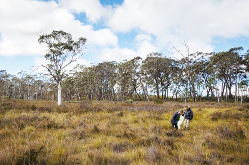
Figure 2. Koala team standing in koala habitat near Bonville, Coffs Harbour LGA. From left to right, John Turbill, Martin Smith, Indrie Sonawane, Chris Moon and Martin Predavec. (Photo Dan Lunney 2013).

Mixed results. Rereading our original paper is unsettling. There is an enduring sense that the entire exercise, while locally worthwhile, has not translated into wider successes with respect to policy and implementation. Although our assessment of the success of the Coffs Harbour CKPoM is upbeat, the uptake of the concept by other councils has been modest. Some have opted for a koala plan of management, but not within the SEPP 44 framework, and others have contracted the preparation of the plans, but only using field survey data for koalas, not the citizen science component.

Among our reflections on our work is that the languages of planning, conservation and ecology need to be calibrated. Confusion has occurred because SEPP 44 refers to potential and core koala habitat when a Development Application (DA) is being assessed, but in the CKPoM in 1999 we used the terms primary, secondary and tertiary koala habitat. Adoption by local government of a CKPoM replaces the requirement to assess each individual DA for core habitat, because the CKPoM has mapped and ranked this habitat. In fact, the ease of seeing koala habitat on a map, ranked so that you know what development is possible, or not, within the particular ranking, expedites the DA process for all parties. This was a major selling point for Coffs Harbour council, along with our economic study which demonstrated that the value of having a koala population in the LGA exceeded the cost of implementing such a plan (Fig 3). While habitat ranking is appropriate for a CKPoM – a land-use planning and management instrument – one interpretation, a misguided one in our view, has been that primary habitat equals core habitat, and deems primary habitat in a CKPoM to be the only level of habitat to conserve. Such a view not only disregards the value of rankings for the purpose of planning, but also ignores the multiple ways that koalas need to use the landscape. We note that more recent plans have divided secondary habitat into secondary A and secondary B, but that does not change the principle of ranking. We also note that a recent choice is to use ‘core’ habitat in a CKPoM, although with a different approach to defining ‘core’, but this has yet to be consolidated in the proposed revised SEPP 44. On reflection, ‘core’ has become a problematic word because it implies that anything other than core can be ignored.

There have been considerable recent efforts to catch up on survey methods for koalas in State Forests. However, pressure remains on State Forests concerning their koala populations, such as the campaign by the National Parks Association of NSW for ‘The Great Koala National Park’ to add 175,000 ha of State Forests to existing protected areas to form a 315,000 ha reserve in the Coffs Harbour hinterland. National Parks and Nature Reserves are a central element in our efforts to conserve our fauna, but a transfer of State Forests to National Parks does not come to grips with the issue of the loss of habitat on private lands, including in situ habitat and linkages across the landscape.

SEPP 44 was promulgated in 1995, and while we recognise that it needs to be updated, our point remains that it has demonstrated potential to conserve koala habitat on private land, with an explicit role, indeed a key role, for local government. Strategies to conserve and restore koala habitat on private land—particularly on the more fertile lands, which are also the prime lands for farms and towns—will continue to be central to conserving the koala populations in NSW.

Figure 3. Economist Clive Hamilton explaining the economic advantages of conserving koalas in Coffs Harbour LGA. This presentation was given in Coffs Harbour at a national meeting for Ecological Economics. (Photo Dan Lunney 1996.)

Lessons learned and future directions. In 2019, our reflections on our 10-year study (1990-2000) allow us to conclude that identifying koala habitat on private land is possible, that plans to conserve it are acceptable, that the economic aspect is an important factor in the negotiations, and that local government has a role to play in this process. Since 2002 we have expanded our research horizon, crossing other disciplinary boundaries to encompass ecological history, using more sophisticated approaches to citizen science, stretching our geographical horizon to the north-west of NSW, incorporating the pervasive impact of climate change, and teasing out the contribution of koala care and rehabilitation and the value of detailed population studies such as by radio-tracking. We also conclude that local studies, especially repeated studies, e.g. at the LGA or Local Land Services (LLS) scale, are crucial, along with broad scale, periodic, state-wide surveys to keep track of the considerable individual differences across the geographic range of the koala.

Contact.  Daniel Lunney, Department of Planning, Industry and Environment NSW (PO Box 1967, Hurstville NSW 2220 and the University of Sydney, NSW 2006. dan.lunney@environment.nsw.gov.au

Waterponding the Marra Creek, NSW rangelands – UPDATE of EMR feature

Ray Thompson and Central West Local Land Services

[Update of EMR feature – Thompson, Ray F (2008) Waterponding: Reclamation technique for scalded duplex soils in western New South Wales rangelands. Ecological Management & Restoration 9:3, 170-181. https://onlinelibrary.wiley.com/doi/10.1111/j.1442-8903.2008.00415.x]

Figure 1.  Scalded country with 30cm of sandy loam topsoil swept away by wind after extensive overgrazing. (Photos NSW SCS)

Introduction. Overgrazing of native pastures in the second half of the 19th Century stripped vegetation and led to the wind erosion of sandy topsoil during inevitable dry periods.  By the 1960s, tens of thousands of square kilometres of rangeland sites in western NSW had a legacy of moderate or severely bare or ‘scalded’ lands. This left bare and relatively impermeable clay subsoil which prevents water penetration and is very difficult for plants to colonize (Fig 1.)

Waterponding is the holding of water on the scald in surveyed horseshoe-shaped banks, each covering 0.4 ha. The ponds retain up to 10 cm of water after rain which leaches the soluble salts from the scalded surface. This improves the remaining soil structure, inducing surface cracking, better water penetration and entrapment of wind-blown seed. Consequently, niches are formed for the germination of this seed and recovery of a range of (typically around 15 out of a total of about 30) locally native chenopod (saltbush) grassland species on the sites.

The original 2008 EMR feature described how barren scalds at a range of properties in Marra Creek, near Nyngan in semi-arid NSW were transformed during the 1980s and 1990s into biodiverse native pastures through a technique called ‘waterponding’ developed after five decades of work by consecutive soil conservation officers exploring a range of prototype treatments.  Over time, a wide range of machines have been used to construct waterponding banks including standard road graders (ridged frame and articulated) or similar. Pre-1985 road graders were generally too small to construct banks of sufficient size, which resulted in too many breached banks. Over a 4-year period, the Marra Creek Waterponding Demonstration Program, backed by committed landowners, researched different horsepower road graders, constructing different size banks, winning the dirt from different locations, and evaluating the economics of construction methods. The results showed that the higher-powered articulated road graders exceeding 200 HP proved to be the most economical and efficient for waterpond construction. This type of machine has the power to  form the bank with one pass on the inside of the bank and two passes on the outside, achieving a bank with well over 2 m base width and over 60 cm in height (Fig. 2).

Figure 2. The process of of waterponding including (a) ute-mounted laser levelling to design the waterpond for a particular site, (b) bulldozing the pond walls to the designed levels, (c) rainfall filling the pond to allow deep watering and cracking of the clay subsoil and (d) resulting revegetation within the walls of the pond. (Photos NSW SCS)

Update and the broader program.  Photos and pasture measurements undertaken on ‘Billabong’ Marra Creek NSW, till 2014 show that the waterponding site had increased ground cover (predominantly native species) from 1% in 2005 to 84 % in 2014. After five to seven rainfall years a typical treatment can result in recovery of up to 15 native species from a range of up to 31 species (Table 1). The method in the last 20 years has also included broadcasting seed of some of the more important perennial species of healthy native chenopod grasslands including  Oldman  Saltbush  (Atriplex nummularia), Bladder Saltbush (Atriplex vesicaria) and Mitchell Grass (Astrebla   lappacea) (Fig 3).  Landholders in the Marra Creek district observe a range of fauna frequently on and between the ponds, including Western Grey Kangaroo (Macropus fuliginosus), Red Kangaroo (Macropus rufus), Emu (Dromaius novaehollandiae), Brolga (Grus rubicunda) and the Eastern Bluetongue Lizard (Tiliqua scincoides). A species of Monitor (Varanus sp.) also sometimes traverses the waterponds. Formal monitoring of smaller reptile and invertebrate use of waterponded sites is yet to occur.

Figure 3. Curly Mitchell Grass (Astrebla lappacea) sown on pond banks. (Photo NSW SCS)

Marra Creek was not the first series of waterponding programs in the Nyngan area – nor the last. The outputs of the entire program by 2019 included over 80,000 waterponds laid out and constructed, resulting in 40,000 hectares returned to local native vegetation. A total of 164 properties in the rangelands area are now using waterponding, the majority of landholders in the Marra Creek district and representing an increase from 17 landholders back in 1984 when we first ran the waterponding.

Figure 4. Landholders themselves are teaching the Waterponding technique to other landholders. (Photos NSW SCS)

Economic model of waterponding. The primary driver for land reclamation was not biodiversity conservation but returning the natural capital of rangelands. As such the program has returned a clear profit to the landholders in terms of increased native pastures that can be grazed, improving ecologically sustainable income sources for farming families.

With the reinstatement of vegetation, there have be increases in total stock feed, resulting in an increase in lambing percentages and wool cuts, as well as the ability to carry stock further into prolonged dry periods with overhead cost per head remaining static. Once rehabilitation has been completed, stocking  rates have been raised from zero to one sheep to 1.5 ha. This iseffectively the long-term grazing average for  saltbush pastures in the Nyngan district.

A treatment involving the full design and survey, pond construction and revegetation cost the landholder about $144.00 per hectare. (This includes approximately $25 a hectare for seed.) If the landholder does all the work the cost is reduced to $72/ha. The type of land involved was calculated in 2008 to normally  have  a  resale  value  of  about $365.00 per hectare In its unproductive state.  Scalded land does not contribute to the farm income yet still incurs rates. Investment in rehabilitation, in contrast, improves carrying capacity thus reducing hand-feeding costs, improving lambing percentages and avoiding forced stock sales. This allows landholders to pass the property to the next generation in a far better condition than it has been previously.

Research has found that the scalds store approximately 18.7 t/h of soil organic carbon to a depth of 30 cm. Once the landscape has been restored by waterponding and revegetation, we have found there is a rapid increase in soil organic carbon up to 25 t/ha within five years. The results are indicating that land in the rangelands that has been rehabilitated using waterponds does sequester carbon. This could lead on to waterponding being eligible for a carbon abatement activity and hopefully lead to Carbon Farming Initiative activity for carbon credits.

Figure 5. Australian National University students attending ‘21 years of participation in Rangelands Waterponding’. (Photos NSW SCS)

Potential for further application. After decades of field days and uptake of the methodologies by local graziers (Fig. 4), waterponding now forms part of standard district farming methodologies and landholders are now passing on knowledge to new generations, including through universities (Fig. 5). The methodologies have also been applied at one national park and one Trust For Nature site in Victoria, and are being applied in the Kimberley, with potential for far greater application in desert conservation reserves throughout Australia and the rest of the world (See Fig. 6 and https://justdiggit.org/approach-2/#).

Contact. Kyra Roach, Central West Local Land Services, Nyngan, 2825 Australia. Email: kyra.roach@lls.nsw.gov.au
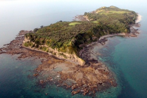
Figure 6. A total of 79 trainees from 26 Africa countries (including Ghana, Tunisia, Rwanda, Burundi and Djibouti) over a three year period were sponsored by AusAid to study waterponding in Nyngan. Resullting work in African countries is making a big difference to degraded lands particularly in North Sudan and Kenya (Photo NSW SCS)

Table 1. Species found in waterponds after standard revegetation treatments and five to seven rainfall years. The species found by Rhodes (1987b) are still commonly found, with additional species (marked with a diamond +) observed by Ray Thompson. (Plant names are consistent with the New South Wales Herbarium database PlantNet, http://plantnet.rbgsyd.nsw.gov.au/ and  growth forms are consistent with Cunningham et al. (1981) (Exotics are marked with an asterisk)

Scientific name Common name Growth form
Alternanthera denticulata Lesser Joyweed Annual forb
Astrebla lappacea+ Curly Mitchell Grass Perennial grass
Atriplex leptocarpa Slender-fruited Saltbush Perennial subshrub
Atriplex lindleyi+ Eastern Flat Top Saltbush Annual subshrub
Atriplex nummularia+ Oldman Saltbush Perennial shrub
Atriplex pseudocampanulata Mealy Saltbush Annual subshrub
Atriplex semibaccata+ Creeping Saltbush Perennial subshrub
Atriplex spongiosa Pop Saltbush Annual forb
Atriplex vesicaria Bladder Saltbush Perennial subshrub
Centipeda thespidioides Desert Sneezeweed Perennial forb
Chamaesyce drummondii Caustic Weed Annual or short-lived perennial forb
Chloris truncata Windmill Grass Annual or perennial grass
Diplachne fusca Brown Beetle Grass Perennial grass
Eragrostis parviflora Weeping Lovegrass Annual or short-lived perennial grass
Eragrostis setifolia Neverfail Perennial grass
Hordeum leporinum* Barley Grass Annual grass
Hordeum marinum* Sea Barley Annual grass
Maireana pentagona Hairy Bluebush Perennial subshrub
Malacocera tricornis Soft Horns Perennial subshrub
Marsilea drummondii Common Nardoo Perennial forb
Medicago minima* Woolly Bur Medic Annual forb
Medicago polymorpha* Burr Medic Annual forb
Osteocarpum acropterum+ Water Weed Perennial subshrub
Phalaris paradoxa* Paradoxa Grass Annual grass
Pimelea simplex Desert Rice-flower Annual forb
Portulaca oleracea Common Pigweed Annual forb
Salsola kali var. kali Buckbush Annual or biennial forb
Sclerolaena brachyptera Short-winged Copperburr Short-lived perennia
Sclerolaena calcarata+ Red Copperburr Perennial subshrub
Sclerolaena divaricata+ Pale Poverty Bush Perennial subshrub
Sclerolaena muricata Black Roly-poly Short-lived perennial
Sclerolaena trycuspis Streaked Poverty Bush Perennial subshrub
Sporobolus actinocladus Katoora Grass Perennial grass
Sporobolus caroli Fairy Grass Perennial grass
Tragus australianus Small Burr Grass Annual grass
Tripogon loliiformis+ Five Minute Grass Perennial grass


Ku-ring-gai Flying-fox Reserve Habitat Restoration Project at Gordon, 2000 – 2019 UPDATE of EMR feature

Nancy Pallin

[Update to EMR feature –  Pallin, Nancy (2001) Ku-ring-gai Flying-fox Reserve Habitat restoration project, 15 years on.  Ecological Management & Restoration 1:1, 10-20. https://onlinelibrary.wiley.com/doi/10.1046/j.1442-8903.2000.00003.x]

Key words:         bush regeneration, community engagement, wallaby browsing, heat events, climate change

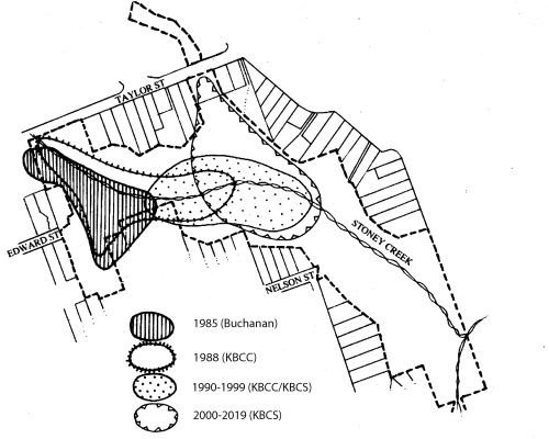
Figure 1. Habitat restoration areas at Ku-ring-gai Flying-fox Reserve within the urban area of Gordon, showing areas treated during the various phases of the project. Post-2000 works included follow up in all zones, the new acquisition area, the pile burn site, the ecological hot burn site and sites where vines have been targeted. (Map provided by Ku-ring-gai Council.)

Introduction. The aim of this habitat restoration project remains to provide self-perpetuating indigenous roosting habitat for Grey-headed Flying-fox (Pteropus poliocephalus) located at Ku-ring-gai Flying-fox Reserve in Gordon, NSW Australia (Fig 1).  The secondary aim was to retain the diversity of fauna and flora within the Flying-fox Reserve managed by Ku-ring-gai Council. Prior to works, weed vines and the activity of flying-foxes in the trees had damaged the canopy trees while dense weed beneath prevented germination and growth of replacement trees.  Without intervention the forest was unable to recover.  Natural regeneration was assisted by works carried out by Bushcare volunteers and Council’s contract bush regeneration team.  The work involved weed removal, pile burns and planting of additional canopy trees including Sydney Bluegum (Eucalyptus saligna), which was expected to cope better with the increased nutrients brought in by flying-foxes.

Figure 2. The changing extent of the Grey-headed Flying-fox camp from the start of the project, including updates since 2000. (Data provided by KBCS and Ku-ring-gai Council)

Significant changes have occurred for flying-foxes and in the Reserve in the last 20 years.

In 2001 Grey-headed Flying-fox was added to the threatened species lists, of both NSW and Commonwealth legislation, in the Vulnerable category.  Monthly monitoring of the number of flying-foxes occupying the Reserve  has continued monthly since 1994 and, along with mapping of the extent of the camp, is recorded on Ku-ring-gai Council’s Geographical Information System. Quarterly population estimates contribute to the National Monitoring Program to estimate the population of Grey-headed Flying-fox.  In terms of results of the monitoring, the trend in the fly-out counts at Gordon shows a slight decline.  Since the extreme weather event in 2010, more camps have formed in the Sydney basin in response to declining food resources.

In 2007, prompted by Ku-ring-gai Bat Conservation Society (KBCS), the size of the Reserve was increased by 4.3 ha by NSW Government acquisition and transfer to Council of privately owned bushland. The Voluntary Conservation Agreement that had previously established over the whole reserve in 1998 was then extended to cover the new area.   These conservation measures have avoided new development projecting into the valley.

From 2009 Grey-headed Flying-fox again shifted their camp northwards into a narrow gully between houses (Fig 2).  This led to human-wildlife conflict over noise and smell especially during the mating season. Council responded by updating the Reserve Management Plan to increase focus on the needs of adjoining residents.  Council removed and trimmed some trees which were very close to houses. In 2018 the NSW Government, through Local Governments, provided grants for home retrofitting such as double glazing, to help residents live more comfortably near flying-fox camps.

Heat stress has caused flying-fox deaths in the Reserve on five days since 2002. Deaths (358) recorded in 2013, almost all were juveniles of that year.  KBCS installed a weather station (Davis Instruments Vantage Pro Plus, connected through a Davis Vantage Connect 3G system) and data loggers to provide continuous recording of temperature and humidity within the camp and along Stoney Creek.  The station updates every 15 minutes and gives accurate information on conditions actually being experienced in the camp by the flying-foxes. The data is publicly available http://sydneybats.org.au/ku-ring-gai-flying-fox-reserve/weather-in-the-reserve/Following advice on the location and area of flying-fox roosting habitat and refuge areas on days of extremely high temperatures (Fig 3.) by specialist biologist Dr Peggy Eby, Council adopted the Ku-ring-gai Flying-fox Reserve 10 Year Management and Roosting Habitat Plan in 2018.  Restoration efforts are now focused on improving habitat along the lower valley slopes to encourage flying-foxes to move away from residential property and to increase their resilience to heat events which are predicted to increase with climate change.

Figure 3. Map showing the general distribution of flying-foxes during heat events, as well as the location of exclosures. (Map provided by Ku-ring-gai Council)

Further works undertaken.  By 2000 native ground covers and shrubs were replacing the weeds that had been removed by the regeneration teams and Bushcare volunteers.  However, from 2004, browsing by the Swamp Wallaby (Wallabia bicolor) was preventing growth of young trees and shrubs.  Bushcare volunteers, supported by KBCS and Council responded by building tree cages made from plastic-mesh and wooden stakes. Reinforcing-steel rods replaced wooden stakes in 2008.   From 2011, the Bushcare volunteers experimented with building wallaby exclosures, to allow patches of shrubs and groundcovers to recover between trees (Figs 3 and 4).  Nineteen wallaby exclosures have been built. These range in size from 7m2 to 225m2 with a total area of 846m2.   Wire fencing panels (Mallee Mesh Sapling Guard 1200 x 1500mm) replaced plastic mesh in 2018.  Silt fence is used on the lower 0.5m to prevent reptiles being trapped and horizontally to deter Brush Turkey (‎Alectura lathami) from digging under the fence.

The wallaby exclosures have also provided an opportunity to improve moisture retention at ground level to help protect the Grey-headed Flying-fox during heat events.  While weed is controlled in the exclosures south of Stoney Creek, those north of the creek retain Trad and privets, consistent with the 10 Year Management and Roosting Habitat Plan.

Madeira Vine (Anredera cordifolia) remained a threat to canopy trees along Stoney Creek for some years after 2000, despite early treatments.  The contract bush regen team employed sInce 2010 targeted 21 Madiera Vine incursions.

A very hot ecological burn was undertaken in 2017 by Council in order to stimulate germination of soil stored seed and regenerate the Plant Community Type (PCT) – Smooth-barked Apple-Turpentine-Blackbutt tall open forest on enriched sandstone slopes and gullies of the Sydney region (PCT 1841).  This area was subsequently fenced. The contract bush regeneration team was also employed for this work to maintain and monitor the regeneration in the eco-burn area (720 hours per year for both the fire and Madiera Vine combined).

Figure 4. Exclusion fence construction method. Pictured are Bushcare volunteers, Jill Green and Pierre Vignal. (Photo N Pallin).

Figure 5. Natural regeneration in 2018 in (unburnt) exclosure S-6 (including germination of Turpentines). (Photo N. Pallin)

Further results to date. The original canopy trees in Phase 1 and Phase 2 (1987 -1997) areas have recovered and canopy gaps are now mostly closed. Circumference at breast height measurements were taken for seven planted Sydney Blue gum trees.  These ranged from 710 to 1410mm with estimated canopy spread from 2 to 6m.  While original Turpentine (Syncarpia glomulifera) had circumferences from 1070 and 2350mm with canopy spread estimated between 5and 8m, those planted or naturally germinated now have circumference measurements between 420 and 980mm with canopy spread estimated from 1.5 to 3m.  A Red Ash (Alphitonia excelsa) which naturally germinated after initial clearing of weeds now has a circumference of 1250mm with a canopy spread of 5m.  Also three Pigeonberry Ash (Elaeocarpus kirtonii) have circumference from 265 to 405mm with small canopies of 1 to 2m as they are under the canopies of large, old Turpentines.  As predicted by Robin Buchanan in 1985 few Blackbutt (Eucalyptus pilularis) juveniles survived while the original large old trees have recovered and the Sydney Bluegum trees have thrived.

In the Phase 3 (1998 – 2000) area south of Stoney Creek the planted Sydney Blue Gum now have circumferences measuring between 368 and 743 (n7) with canopy spread between 2 and 6 m.  in this area the original large trees have girths between 1125 and 1770mm (n7) whereas trees which either germinated naturally or were planted now range from 130 to 678mm (n12).  These measurement samples show that it takes many decades for trees to reach their full size and be able to support a flying-fox camp.

Wallaby exclosures constructed since 2013 south of Stoney Creek contain both planted and regenerated species.  Eight tree species, 11 midstorey species, 27 understorey species and eight vines have naturally regenerated.  Turpentines grew slowly, reaching 1.5m in 4 years.  Blackbutts thrived initially but have since died. In exclosures north of the creek,  weeds including Large-leaved Privet,  Ligustrum lucidum,  Small-leaved privet,  L. sinense,  Lantana, Lantana camara,  and Trad, Tradescantia fluminensis) have been allow to persist and develop to maximise ground moisture levels for flying-foxes during heat events. Outside the exclosures, as wallabies have grazed and browsed natives, the forest has gradually lost its lower structural layers, a difference very evident in Fig 6.

Figure 6. Visible difference in density and height of ground cover north and south of Stoney creek. (Photo P. Vignal)

Coachwood (Ceratopetalum apetalum) were densely planted in a 3 x 15m exclosure under the canopies of mature Coachwood next to Stoney Creek in 2015. In 4 years they have reached 1.5m.  In this moist site native groundcovers are developing a dense, moist ground cover.

Madiera Vine, the highest-threat weed, is now largely confined to degraded edges of the reserve, where strategic consolidation is being implemented with a view to total eradication.

In the hot burn area, which was both fenced and weeded, recruitment has been outstanding. One 20 x 20m quadrat recorded 58 native species regenerating where previously 16 main weed species and only 6 native species were present above ground. A total of 20 saplings and 43 seedlings of canopy species including Eucalyptus spp., Turpentine and Coachwood were recorded in this quadrat where the treatment involved weed removal, burning and fencing  (S. Brown, Ku-ring-gai Council, July 2019, unpublished data).  Unfortunately, however, the timing and location of the burn did not take into account its impact on the flying-fox camp and there was some damage to existing canopy trees. It will be many years before the canopy trees, which are regenerating, will be strong enough to support flying-foxes.

Monitoring from the weather station and data loggers has shown that close to Stoney Creek on a hot day it is typically 2-3° C cooler, and 5-10% higher in humidity, than in the current camp area (pers. comm. Tim Pearson). During heat events the flying-foxes move to this cooler and moister zone, increasing their chances of survival.

Fauna observed other than flying-foxes includes a pair of Wedge-tail Eagle ( Aquila audax plus their juvenile, a nesting Grey Goshawk (Accipiter novaehollandiae) and a Pacific Baza (Aviceda subcristata).  Powerful Owl (Ninox strenua) individuals continue to use the valley. The presence of raptors and owls indicate that the ecosystem processes appear to be functional. Despite the decline of the shrub layer outside fenced areas, the same range of small bird species (as seen prior to 2000) are still seen including migrants such as Rufous Fantail ( Rhipidura rufifrons) which prefers dense, shady vegetation. The first sighting of a Noisy Pitta (Pitta versicolor) was in 2014.  Long-nosed Bandicoot (Perameles nasuta) individuals appear and disappear, while Swamp Wallaby remains plentiful.

Lessons learned and future directions. Climate change is an increasing threat to Pteropus species. On the advice of Dr Eby, Flying-fox Consultant, Council, KBCS and Bushcare Volunteers agreed to retain all vegetation including weeds such as Large-leaved Privet and Small-leaved Privet, patches of the shrub Ochna (Ochna serrulata) and Trad as a moist ground cover in the camp area and areas used by the flying-foxes during heat events.

Building cheap, lightweight fencing can be effective against wallaby impacts, provided it is regularly inspected and repaired after damage caused by falling branches. This style of fencing has the additional advantage of being removable and reusable.  It has been proposed that, to provide understory vegetation to fuel future burns in parts of the reserve away from the flying-fox camp, further such temporary fencing could be installed.

Ku-ring-gai Council has commenced a  program to install permanent monitoring points to annually record changes in the vegetation, consistent with the state-based  Biodiversity Assessment Method.

Stakeholders and Funding bodies. Members of KBCS make donations, volunteer for monthly flyout counts, Bushcare and present educational events with live flying-foxes. KBCS hosts the website www.sydneybats.org.au. Ku-ring-gai Council which is responsible for the Reserve has been active in improving management to benefit both residents and flying-foxes.  Ku-ring-gai Environmental Levy Grants to KBCS have contributed substantially to purchase of fencing materials and the weather station. http://www.kmc.nsw.gov.au/About_Ku-ring-gai/Land_and_surrounds/Local_wildlife/Native_species_profiles/Grey-headed_flying-fox

Thank you to Jacob Sife and Chelsea Hankin at Ku-ring-gai Council for preparing the maps and to volunteer Pierre Vignal for assistance with tree measurements, downloading data loggers and a photo.  Researcher,  Tim Pearson installed the weather station.

Contact information. Nancy Pallin, Management Committee member, Ku-ring-gai Bat Conservation Society Inc.  PO Box 607, Gordon 2072  Tel 61 418748109. Email:  pallinnancy@gmail.com

Monitoring the Wunambal Gaambera Healthy Country Plan, Kimberley, Western Australia – UPDATE of EMR feature

[Update to EMR feature: Moorcroft, Heather, Emma Ignjic, Stuart Cowell, John Goonack, Sylvester Mangolomara, Janet Oobagooma, Regina Karadada, Dianna Williams and Neil Waina (2012) Conservation planning in a cross‐cultural context: the Wunambal Gaambera Healthy Country Project in the Kimberley, Western Australia,  Ecological Management & Restoration, 13:1, 16-25. See https://doi.org/10.1111/j.1442-8903.2011.00629.xk]

Key words: conservation planning, participatory conservation, Indigenous people, Kimberley

Figure 1. Location map of Wunambal Gaambera land and sea country. (Source: WGAC)

Introduction. The development of the Wunambal Gaambera Healthy Country Plan (HCP) was a key enabler for Wunambal Gaambera people to look after country (Fig 1) and occurred at an important time when native title rights to country were being secured. The plan came about through a partnership between Wunambal Gaambera Aboriginal Corporation (WGAC) and Bush Heritage Australia (BHA), who brought the planning approach and supported WGAC to develop a plan that met the needs of Traditional Owners. This plan then became the basis of a long term partnership between the two organisations to support implementation.

Healthy Country Planning, a term coined by this project, adapted the Open Standards for the Practice of Conservation (http://cmp-openstandards.org/ ) to an Indigenous native title community context. The approach has subsequently flourished in Australia, adopted by a further 30 indigenous groups ( see doi: 10.1111/emr.12267).

The unique partnership model established between BHA and WGAC, underpinned by Healthy Country Planning, has also expanded (https://www.bushheritage.org.au/what-we-do/aboriginal-partnerships). The program supports indigenous partners to achieve their community and conservation aspirations articulated through Healthy Country Planning.

Figure 2. Terrick Bin Sali handling a northern quoll (Dasyurus hallucatus). (Photo WGAC)

Conservation planning with a difference. Our experience has been that the Open Standards can be successfully applied to an Indigenous context but some important adaptation is required. For example:

  1. People, culture and country are inseparable in Australian indigenous worldviews. As such, Healthy Country Planning is much wider in scope than mainstream conservation or natural resource management planning. The vision in the HCP typically sets long-term goals that include aspirations for looking after country and achieving health conditions for landscapes, seascapes, plants and animals, as well as for people and culture (Figs 2-4). These outcomes are collectively referred to as “Healthy Country”. An indigenous plan will always recognize and value people in the landscape rather than as separate. Traditional Owners, and/or their culture, become a conservation target alongside species and habitats with ‘key cultural attributes’ established alongside ‘key ecological attributes’. HCPs also have a greater degree of management strategies that relate to people and culture than would be found in mainstream management plans, and culture and Indigenous Knowledge is incorporated into land management activities that could be considered mainstream, such as the inclusion of cultural rules within visitor management.
  2. The Open Standards include approaches and tools for stakeholder participation that lend themselves well to Indigenous peoples, however given that Indigenous lands are communally-owned and governed by unique law and culture systems, participation requirements are higher and more complex. Traditional systems of governance are often recognized under State and Federal Law (such as the Native Title Act) requiring additional process steps. In developing the HCP, WGAC undertook a process of involving all Traditional Owner families in various stages of planning and the plan was authorized at a Traditional Owner meeting.
  3. A Healthy Country Plan typically applies to the whole traditional estate of a Traditional Owner group regardless of tenure, consistent with the concept of “Country-based Planning”. WGAC initially dedicated stage I of the Uunguu Indigenous Protected Area over several aboriginal reserves in 2010, and later added exclusive possession lands following native title determination. The marine environment will also be added to the IPA once agreement is reached with State and Commonwealth Governments, as articulated in the Uunguu Wundaagu Plan.

Figure 3. Traditional Owners undertaking a ‘junba’ traditional dance workshop. (Photo: WGAC)

Monitoring & evaluation since 2012. Aspects of the monitoring and evaluation framework established by WGAC include the establishment of the Uunguu Monitoring & Evaluation Committee (UMEC) and the completion of mid-term evaluation of the HCP (see 2017 review doi:10.1111/emr.12257). The UMEC is composed of Traditional Owners and external experts who undertake key Healthy Country Planning steps and functions. A significant investment of time and money was required to support annual or biennial meetings “on country” (ie. on Wunambal Gaambera lands), however the review showed that the investment has proven worthwhile because WGAC has been able to implement the plan to a high degree.

In 2015 a major mid-term evaluation was undertaken to assess the progress of the HCP. It utilized some standard evaluation tools examining Open Standards process. It also incorporated some new approaches to include the views of the wider Traditional Owner community in the evaluation of the plan to ensure the plan was meeting their needs and following effective process with regard to governance and participation. The review made a number of observations as follows.

  1. Considerable progress had been made in the implementation of fire management strategies in the HCP to the point that the health condition of the “Right Way Fire” target was changed from ‘fair’ to ‘good’. Unmanaged wildfires have significantly reduced in size as a result of increased capabilities of the Uunguu Rangers to undertake burning. At the same time “right way” cultural principles have been incorporated into operations to ensure that Traditional Owner families are making decisions about burning and undertaking fire operations on their family areas.
  2. Significant progress has been made against a visitor management strategy. One of the key concerns of elders when developing the plan was unregulated visitation to important cultural sites by the expedition cruise industry and independent travelers. The Uunguu Visitor Pass, launched in 2017, requires visitors to obtain a permit to access authorized visitor locations as well as generating funds for looking after country. Over 90% of commercial tour operators have now registered for the UVP, with a similar independent traveler compliance, generating funds to support Traditional Owner participation in visitor management and delivering tour products.
  3. Progress was not made, however, in the health of cultural targets in the plan. As a result, the 2015 review recommended further investment and effort in culture strategies. Two important books have been completed to document elders’ knowledge of biodiversity and cultural places. There has been an increase in cultural activities including language and corroboree dance workshops and annual culture camps for school children. Law and culture dictates that visitors to country (indigenous or non-indigenous) need to be accompanied by the right local Traditional Owners when undertaking activities on country. In this way Healthy Country work supports large numbers of Traditional Owners to visit country and guide participation in the implementation of the plan. A number of actions have been undertaken to support Traditional Owners to live on country and remote ranger infrastructure has been developed.

Figure 4. Uunguu Rangers during a cultural fire walk. (Photo WGAC)

Future Directions. The first 8 years of the HCP implementation has focused on building WGAC’s land and sea management capacity and resources, with funding from WGAC,  the Australian Governments Indigenous Protected Area and Indigenous Ranger Programs and from Bush Heritage Australia. Traditional Owners currently hold certificate level roles of rangers, tourism workers and construction workers but further work is now needed to support Traditional Owners to take on roles that require higher levels of training. There is also a need to support the development of a wider range of livelihoods to support Traditional Owners to live and/or work on country.

Contact information. Wunambal Gaambera Aboriginal Corporation, PMB 16 Kalumburu via Wyndham WA 6740, Australia.

Email: info@wunambalgaambera.org.au

Web: www.wunambalgaambera.org.au

Facebook: https://www.facebook.com/uunguulife/


Recovery of indigenous plants and animals in revegetated areas at ‘The Waterways’, Victoria.

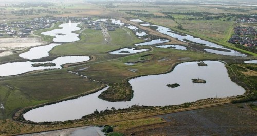
Photo 1.  Aerial view of Waterways from the west

By Damien Cook

 Introduction. Waterways is a 48-hectare restoration project located on Mordialloc Creek in Melbourne’s south- eastern suburbs which combines a housing estate with large areas of restored habitat set aside for indigenous fauna and flora in open space, lakes and other wetlands (see Photo 1).

Prior to restoration the land at Waterways was a property used for grazing horses and supported pasture dominated by exotic species such as Reed Fescue (*Festuca arundinacea) and Toowoomba Canary Grass (*Phalaris aquatica). (Note that an Asterix preceding a scientific name denotes that the species is not indigenous to the local area).

The habitats which are being restored at “The Waterways” reflect those that originally occurred in the Carrum Carrum Swamp, a vast wetland complex which, prior to being extensively drained in the 1870s, stretched from Mordialloc to Kananook and as far inland as Keysborough.

Local reference ecosystems were selected to act as a benchmark for what was to be achieved in each restored habitat in terms of species diversity and cover. Habitat Hectare assessments have been used to monitor the quality of restored vegetation (see Appendix 1).

A total of nine Ecological Vegetation Classes (EVCs, the standard unit of vegetation mapping in Victoria) are being re-established across the site across the following habitats

  • Open water, Submerged Aquatic Herbfields and Exposed Mudflats
  • Densely vegetated marshes
  • Swamp Paperbark Shrubland
  • Tussock Grassland
  • Plains Grassy Woodland

Photo 2. This sequence of photographs, taken over a nine-month period at the Waterways, shows vegetation establishment in a constructed wetland from newly constructed and bare of native species on the left to well vegetated with a high cover of indigenous plants and minimal weeds on the right.

Works undertaken. Restoration of the site commenced in October 2000. Extensive weed control and earthworks were carried out prior to the commencement of revegetation works, which involved planting, by 2003, over 2 million local provenance, indigenous plants.  Grassland species were planted out of hikos at a density of 5 to 6 per square meter into areas that had been treated with both knock-down and pre-emergent herbicide. Ongoing management of the site has included ecological burning and follow up weed control. When started the Waterways was the largest and most complex ecological restoration project ever undertaken in Victoria.

Results

Plants

Open water, Submerged Aquatic Herbfields and Exposed Mudflats.  Deep, open water areas cover an area of about 30 hectares of the site. Vegetation growing in this habitat includes submerged herb-fields of Pondweeds (Potamogeton species), Eel Grass (Vallisneria australis) and Stoneworts (Chara and Nitella species), which were planted over summer 2000/01.

Densely vegetated marshes. This habitat occupies about 10 hectares of the site, occurring where water is less than 1.5 meters deep around the fringes of the lakes and as broad bands across the wetlands. Swards of large sedges including Tall Spike-rush (Eleocharis sphacelata), Jointed Twig-sedge (Baumea articulata), Leafy Twig-sedge (Cladium procerum) and River Club-rush (Schoenoplectus tabernaemontani); aquatic herb-fields of Water Ribbons (Cycnogeton procerum), Upright Water-milfoil (Myriophyllum crispatum) and Running Marsh-flower (Ornduffia reniformis); as well as meadows supporting rushes, sedges and amphibious herbs. Localized areas with high salinity (4000 to 12 000 ppm) have been planted with a halophytic (salt tolerant) community including Sea Rush (Juncus krausii), Australian Salt-grass (Distichlis distichophylla), and Shiny Swamp-mat (Selliera radicans). Planting began in the marshes at the Waterways in October 2000 and vegetation established very rapidly in most areas (see Photo 2). This vegetation type provides habitat for the locally vulnerable Woolly Water-lily (Philydrum lanuginosum).

Swamp Paperbark Shrubland covers about 8 hectares, consisting of a 1ha remnant and additional areas that were planted in spring/summer 2001. As this shrubland habitat matures it is forming a dense canopy of species including Swamp Paperbark (Melaleuca ericifolia), Prickly Moses (Acacia verticillata subsp. verticillata), Manuka (Leptospermum scoparium), Woolly Tea-tree (Leptospermum lanigerum), Tree Everlasting (Ozothamnus ferrugineus) and Golden Spray (Viminerea juncea).

Photo 3. Rare plant species that have been established in restored native grasslands at “Waterways” include Grey Billy-buttons (Craspedia canens), Matted Flax-lily (Dianella amoena) and Pale Swamp Everlasting (Coronidium gunnianum).

Tussock Grassland covers about four hectares at the Waterways between two major wetland areas. About a third of this habitat was planted in spring 2001, with the remainder in spring 2002. The dominant plants of this habitat are tussock-forming grasses including wallaby grasses (Rytidosperma species), Kangaroo Grass (Themeda triandra) and Common Tussock Grass (Poa labillardierei var. labillardierei). A diverse array of native wildflowers occurs amongst these grasses. Rare plant species that have been established in this habitat zone include Grey Billy-buttons (Craspedia canens), Matted Flax-lily (Dianella amoena) and Pale Swamp Everlasting (Coronidium gunnianum, see Photo 3).

Plains Grassy Woodland This habitat type occurs in mosaic with Tussock grassland and differs in that it supportsscattered trees and clumps of shrubs. River Red Gum (Eucalyptus camaldulensis subsp. camaldulensis) and Swamp Gum (Eucalyptus ovata var. ovata) have been planted so that they will eventually form an open woodland structure. Other tree and tall shrub species planted in this habitat include Drooping Sheoak (Allocasuarina verticillata), Blackwood (Acacia melanoxylon) and the tree form of Silver Banksia (Banksia marginata), which is now very uncommon in the local area.

Seasonal Wetlands Small seasonal wetlands occur within Tussock Grassland (see Photo 4). Rare plant species that have been established in this habitat zone include Swamp Billy-buttons (Craspedia paludicola), Woolly Water-lily (Philydrum lanuginosum), Grey Spike-rush (Eleocharis macbarronii), Giant River Buttercup (Ranunculus amplus) and the nationally endangered Swamp Everlasting (Xerochrysum palustre).


Photo 4. Seasonal rain-filled wetland at Waterways

 Animals.

The Waterways is home to 19 rare and threatened fauna species including the nationally endangered Australasian Bittern (Botaurus poiciloptilus), Glossy Grass Skink (Pseudemoia rawlinsoni) and Magpie Goose (Anseranas semipalmata). The successful establishment of diverse vegetation has so far attracted 102 species of native birds, and the wetlands on the site are home to seven species of frogs.

Open water areas support large populations of Black Swans (Cygnus atratus), Ducks (Anas species), Eurasian Coots (Fulica atra), Cormorants (Phalacrocorax and Microcarbo species), Australian Pelicans (Pelecanus conspicillatus) and Australasian Darters (Anhinga novaehollandiae) that either feed on fish and invertebrates or the foliage and fruits of water plants.  As water levels recede over summer areas of mudflat are exposed. These flats provide ideal resting areas for water birds as well as feeding habitat for migratory wading birds including the Sharp-tailed Sandpiper (Calidris acuminata), Red-necked Stint (Calidris ruficollis) and Common Greenshank (Tringa nebularia) that fly from their breeding grounds as far away as Alaska and Siberia to spend the summer in Australia and are protected under special treaties between the Governments of countries through which they travel.

Photo 5. Magpie Geese (Anseranas semipalmata) at Waterways

In 2007 a small group of Magpie Geese (Anseranas semipalmata) became regular visitors to The Waterways (see Photo 5). This species was once extremely abundant in the Carrum Carrum Swamp. However, it was driven to extinction in southern Australia in the early 1900s by hunting and habitat destruction. The Magpie Goose seems to be making a recovery in Victoria, with numbers building up from birds captured in the Northern Territory and released in South Australia that are spreading across to areas where the species formerly occurred.

Seasonal wetlands are important breeding areas for frogs including the Banjo Frog (Limnodynastes dumerilii), Striped Marsh Frog (Limnodynastes peroni) and Spotted Grass Frog (Limnodynastes tasmaniensis) and a range of invertebrates that do not occur in the larger, more permanent storm water treatment wetlands such as Shield Shrimp (Lepidurus apus viridus). Birds which utilize these wetlands for feeding include the White-faced Heron (Egretta novaehollandiae) and Latham’s Snipe (Gallinago hardwickii).

Restored grassland provides an ideal hunting ground for several birds of prey, including the Brown Falcon (Falco berigora), Black-shouldered Kite (Elanus axillaris) and Australian Kestrel (Falco cenchroides). It also provides cover and feeding habitat for insect and seed-eating birds such as the Brown Quail (Coturnix ypsilophora). A flock of about 20 Blue-winged Parrots (Neophema chrysostoma) have been regularly seen in this habitat. These parrots are usually quite uncommon in the Melbourne area. Moist grasslands beside the wetland have been colonised by the vulnerable Glossy Grass Skink (Pseudemoia rawlinsoni) (see Photo 6).

Densely vegetated marshes provide habitat for a diversity of small, secretive birds such as Ballion’s Crake (Porzana pusilla), Little Grassbird (Megalurus gramineus) and Australian Reed Warbler (Acrocephalus australis), which find suitable refuges in the cover provided by dense vegetation. Dense thickets of Swamp Paperbark shrublands provide cover and feeding habitat for Ring-tail Possums (Pseudocheris peregrinus) and bushland birds such the Eastern Yellow Robin (Eopsaltria australis), thornbills (Acanthiza species), Superb Fairy-wren (Malurus cyaneus) and Grey Fantail (Rhipidura albiscapa). As the grassy woodlands mature they are providing structural habitat diversity and accommodating woodland birds such as cuckoos (Cacomantis and Chalcites species) and pardalotes (Pardalotus species).

It will take many years for the River Red Gums to reach a majestic size and stature, and to provide tree hollows which are essential for many species of native fauna. A limited number of tree hollows are provided in the dead trees (stags) that were placed in the Waterways wetlands.

Photo 6. The vulnerable Glossy Grass Skink (Pseudemoia rawlinsoni) at Waterways

The Future. The habitats that have been created at the Waterways are about 18 years old, yet they have already attracted a vast array of native fauna. Waterways is now home to 14 rare and threatened plant species and 19 threatened animal species. There is incredible potential for the area to provide vitally important habitat for an even greater diversity of rare plants and animals as these habitats mature.

If the area is to reach its full potential careful management of weeds and pest animals is required. Ongoing monitoring of flora and fauna is also necessary. These are both areas in which the local community is becoming involved.

Acknowledgements. The high standard of restoration achieved on the Waterways project was due to the project being appropriately funded and because it was managed by ecologists experienced in planning and implementing ecological restoration.  The project was partly funded by Melbourne Water, who are now the managers of the site, and partly by a developer, the Haines Family.  This unique relationship and the generosity and willingness to try something innovative by the developer were important factors in the success of the project.

Contact: Damien Cook (rakali2@outlook.com.au)

Appendix 1. Habitat Hectare results for four quadrats at Waterways, 2006

Motuora Restoration Project, New Zealand

Key Words: Ecological restoration, reintroductions, island restoration, community engagement, Motuora Restoration Society

Motuora Restoration Society (http://motuora.org.nz) is recognised by the New Zealand Department of Conservation as the lead community agency for the restoration of Motuora, an 80 ha island in the Hauraki Gulf, New Zealand.  Since 2003 the Society has taken responsibility for the Island’s day-to-day management as well as developing and implementing the Island’s long term restoration strategy. Our aspiration is summed up in our  statement “It is our dream that future generations will enjoy a forest alive with native birds, reptiles and insects”.

Figure 1 – Aerial view of the Island before planting began. Area to bottom left has been sprayed in preparation for planting (Photo from cover of 2007 Motuora Native Species Restoration Plan).

Figure 1 – Aerial view of the Island before planting began. Area to bottom left has been sprayed in preparation for planting (Photo from cover of 2007 Motuora Native Species Restoration Plan).

 Figure 2 – Aerial view of the Island after completion of the pioneer planting. (Photo by Toby Shanley)


Figure 2 – Aerial view of the Island after completion of the pioneer planting. (Photo by Toby Shanley)

Background. Motuora is located on the east coast of New Zealand’s North Island near Auckland City. Motuora would once have been tree-covered and have hosted a wide range of native plants, invertebrates, reptiles and birds, particularly burrow-nesting seabirds. It was visited by early Polynesian settlers, later Māori, who would have initially camped, but later lived more permanently on the Island raising crops and harvesting fish, shellfish and presumably seabird eggs, chicks and adults. European settlers later occupied the Island, burning off most of the bush to encourage growth of grasses for their grazing livestock.

Towards the end of the farming period in the 1980s most of the Island’s native flora and fauna were gone. Interestingly however, there were never breeding populations of introduced mammalian pests on the Island so the remnant ecosystem had not been impacted by mice, rats, mustelids, hedgehogs, possums, goats, pigs or deer.

From about 1987 onwards both Government and members of the public began to take an interest in the Island and to promote the idea of adopting it as a predator-free bird habitat. Discussions continued over the next few years and by 1992 a sub-committee of the mid-North Royal Forest and Bird Protection Society had been formed and, in partnership with the Department of Conservation, drew up the first ‘strategy plan’ for the Island. Work parties began seed collecting, trial tree planting, weeding and fencing upgrades. By 1995 it had become apparent that the project could best proceed by way of an independent group dedicated to the task and the Motuora Restoration Society was formed.

The work on Motuora was designed to be a true restoration project combining firm ideas about the model ecosystem desired and a ‘bottom-up’ approach (vegetation-invertebrates-reptiles-birds) timing planting and introductions in a logical sequence. The historical presence of species on Motuora was inferred from comparisons with other less modified islands off the north east of the North Island, and particularly those from within the Rodney and Inner Gulf Ecological Districts, and using paleological information collected from the adjacent mainland.  Motuora Restoration Society has resisted the temptation to add iconic attractive species not originally present on the Island which might have raised the profile of the project.

Works carried out. The Society and its volunteers have contributed many thousands of hours to the restoration of the Island since 1995, raising and planting more than 300,000 native seedlings. This was particularly challenging with the logistics of working on an island without a regular ferry service or wharf. The project also included seabird and other species translocations, monitoring, weeding and track maintenance as well as fundraising.

The framework adopted began with reforestation so that appropriate habitat could be reinstated. A nursery was set up and seeds were collected from the Island, from nearby islands and, when necessary, from the mainland. With the exception of some areas of higher ground providing panoramic views from the Island, the land area was prepared (by weed-killing rampant kikuyu grass) and planted with hardy, wind and salt tolerant tree species. Once the trees were established, the canopy closed and sufficient shelter available, less hardy species and those requiring lower light levels were planted among the pioneers.  Today the planting of 400,000 trees of pioneer species is all but complete; and the raising and planting of ‘canopy’ and less hardy species continues.

In terms of fauna, invertebrate populations were surveyed and have been monitored as the forest has matured. One species, Wētāpunga (Deinacrida heteracantha) has been introduced.   Four reptiles have been introduced: Shore Skink (Oligosoma smithi), Duvaucel’s Gecko (Hoplodactylus duvaucelii),  Raukawa Gecko (Woodworthia maculata) and Pacific Gecko (Dactylocnemis pacificus).  One small land bird – Whitehead (Mohoua albicilla) has been translocated with 40 individuals moved to the Island.  Four seabird species have been attracted or translocated to the Island including the Common Diving Petrel (Pelecanoides urinatrix), and Pycroft’s Petrel (Pterodroma pycrofti).

Results. The project has restored Motuora from a pastoral farm (dominated by introduced grasses, weeds and only a small remnant fringe of naturally regenerating native forest) to a functioning native ecosystem, predominantly covered in early succession native forest with an intact canopy.

Initially the population of invertebrates was dominated by grassland species but the range and population size of forest dwellers has now much improved and the invertebrate fauna is now rich and plentiful (although rarer and endangered species are still to be added).  An initial suite of populations of flightless invertebrates remain depauperate.  Whitehead, an insectivorous bird species, has flourished with a current population of several hundred. At this early stage in the introduction of native fauna it is possible to report successful breeding and, for the most part, sufficient survival of initial colonisers of the species introduced to suggest that new populations will be established.  Sound attraction systems have led to initial breeding of Fluttering Shearwater (Puffinus gavia) and Australasian Gannet (Morus serrator).

Partnerships. Management of the Island is shared with the Department of Conservation (DOC) who administer the site on behalf of the Crown. DOC has legal commitments to engage with and act on behalf of the general public and particularly with iwi (Māori) who have generally expressed strong support for the restoration project and are expected to have co-management rights over the Island in the future.

Over the years the combined efforts of DOC staff, University researchers, the committee, thousands of volunteers and a host of donors and sponsors have worked hard to bring the Island to its present state.

Future directions. A sustained effort will continue to be required each year on biosecurity and weeding programmes. It will be many more decades before the forest matures and seabird and reptile populations reach capacity levels and a substantial workload is anticipated in managing and monitoring the emerging ecosystem for many years to come.

Acknowledgements: The success of the project is reinforced by the fact that the Society has maintained a close collaboration with a range of scientists and have inspired the active support and engagement of so many volunteers.  We thank all our inspiring volunteers and the following participating academics and researchers who have contributed to the project over the past ten years: Plants: Shelley Heiss Dunlop, Helen Lindsay (contractor). Reptiles: Marleen Baling (Massey University), Dylan van Winkel (consultant), Su Sinclair (Auckland Council), Manuela Barry (Massey University). Invertebrates: Chris Green (DOC), Robin Gardner-Gee (Auckland University), Jacqueline Beggs (Auckland University), Stephen Wallace (Auckland University). Birds: Robin Gardner-Gee (Auckland University), Jacqueline Beggs (Auckland University), Kevin Parker (Massey University), Richard Griffiths (DOC), Graeme Taylor (DOC), Helen Gummer (DOC contractor). The restoration project has been supported financially though grant aid received from a wide range of funders.

Contact: Secretary, Motuora Restoration Society, Email: secretary@motuora.org.nz; www: http://motuora.org.nz/

A framework and toolbox for assessing and monitoring swamp condition and ecosystem health

Key words: Upland swamp, stygofauna, sedimentology, ecosystem processes, biological indicators, geomorphology

Introduction. Upland swamps are under increasing pressure from anthropogenic activities, including catchment urbanization, longwall mining, and recreational activities, all under the omnipresent influence of global climate change. The effective management of upland swamps, and the prioritisation of swamps for conservation and restoration requires a robust means of assessing ecosystem health. In this project we are developing a range of ecological and geomorphic indicators and benchmarks of condition specifically for THPSS. Based on a multi-metric approach to ecosystem health assessment, these multiple indicators and benchmarks will be integrated into an ultimate index that reflects the health of the swamp.

In this project we have adopted (and modified) the definition of ecosystem health applied to groundwater ecosystems by Korbel & Hose (2011). We define ecosystem health of a swamp as, i.e., “an expression of a swamp’s ability to sustain its ecological functioning (vigour and resilience) in accordance with its organisation while maintaining the provision of ecosystem goods and services”.

Design. Our approach to develop indicators of swamp health followed those used to develop multimetric indices of river and groundwater ecosystem health (e.g. Korbel & Hose 2011). We used the ‘reference condition’ approach in which a number of un- or minimally disturbed swamps were sampled and the variation in the metric or index then represents the range of acceptable conditions (Bailey et al. 1998; Brierley & Fryirs 2005).

We focused initially on swamps in the Blue Mountains area. Reference (nominally unimpacted) and test sites with various degrees and types of impacts were identified using the database developed by the concurrent THPSS mapping project (Fryirs and Hose, this volume).

Following our definition of ecosystem health, we selected a broad suite of indicators that reflect the ecosystem structure (biotic composition and geomorphic structure) and function, including those relating to ecosystem services such as microbially-mediated biogeochemical functions, geomorphic processes and hydrological function, as well as the presence of stressors, such as catchment changes. Piezometers and dataloggers have been installed in a number of swamps to provide continuous data on groundwater level fluctuations and sediment cores taken at the time of piezometer installation have provided detailed information on the sedimentary structure, function and condition of the swamps.

Results. Intact and channelised swamps represent two geomorphic condition states for THPSS. Not surprisingly, variables reflecting the degree of catchment disturbance (such as urbanization) were strongly correlated with degraded swamp condition. Variables related to the intrinsic properties of swamps had little relationship to their geomorphic condition (Fryirs et al. 2016). Intact and channelized swamps present with typically different sediment structures. There were significant differences in the texture and thickness of sedimentary layers, C: N ratios and gravimetric moisture content between intact swamps and channelised swamps (Friedman & Fryirs 2015). The presence and thickness of a layer of contemporary sand in almost all channelised swamps and its absence in almost all intact swamps is a distinctive structural difference.

Disturbed swamps have poorer water quality at their downstream end, and associated with this, lower rates of organic matter processing occurring within the streams (Hardwick unpublished PhD Data). Similarly, the richness and abundance of aquatic invertebrates living within swamp sediments (stygofauna) is poorer in heavily disturbed swamps than in undisturbed or minimally disturbed areas (Hose unpublished data).

Within the swamp sediments, important biogeochemical processes, such as denitrification and methanogenesis, are undertaken by bacteria. In this study we are measuring the abundance of the functional genes such as a surrogate for functional activity within the swamp sediments. There is large spatial variation in the abundance of functional genes even within a swamp, which complicates comparisons between swamps. Within our focus swamp, the location closest to large stormwater outlets had different functional gene abundances, in particular more methanogens, than in less disturbed areas of the swamp. There were greater abundances of denitrification genes, nirS and nosZ, in shallower depths despite denitrification being an anoxic process, which may reflect changes in the surficial sediments due to disturbance. Overall however, the abundance of functional genes seem to vary more with depth than with location, which means that comparisons between swamps must ensure consistency of depth when sampling sediments (Christiansen, unpublished PhD data).

The list of indicators currently being tested in this project and by others in this program (Table 1) will be refined and incorporated into the final assessment framework. Thresholds for these indicators will be determined based on the range of conditions observed at the reference sites. The overall site health metric will reflect the proportion of indicators which pass with respect to the defined threshold criteria. At this stage, the final metrics will be treated equally, but appropriate weightings of specific metrics within the final assessment will be explored through further stakeholder consultation.

Stakeholders and Funding bodies. This research has been undertaken as PhD research projects of Kirsten Cowley, Lorraine Hardwick and Nicole Christiansen at Macquarie University. The research was funded through the Temperate Highland Peat Swamps on Sandstone Research Program (THPSS Research Program). This Program was funded through an enforceable undertaking as per section 486A of the Environment Protection and Biodiversity Conservation Act 1999 between the Minister for the Environment, Springvale Coal Pty Ltd and Centennial Angus Place Pty Ltd.  Further information on the enforceable undertaking and the terms of the THPSS Research Program can be found at www.environment.gov.au/news/2011/10/21/centennial-coal-fund-145-million-research-program. This project was also partly funded by an ARC Linkage Grant (LP130100120) and a Macquarie University Research and Development Grant (MQRDG) awarded to A/Prof. Kirstie Fryirs and A/Prof. Grant Hose at Macquarie University. We also thank David Keith, Alan Lane, Michael Hensen, Marcus Schnell, Trevor Delves and Tim Green.

Contact information. A/Prof. Grant Hose, Department of Biological Sciences, Macquarie University (North Ryde, NSW 2109; +61298508367; grant.hose@mq.edu.au); and A/Prof. Kirstie Fryirs, Department of Environmental Sciences, Macquarie University (North Ryde, NSW 2109; +61298508367; kirstie.fryirs@mq.edu.au).

Table 1. List of indicators of swamp condition that are being trialled for inclusion in the swamp health assesment toolbox.

Functional indicators table

Testate amoebae: a new indicator of the history of moisture in the swamps of eastern Australia

Key words: Temperate Highland Peat Swamps Sandstone

Introduction. Swamps are an ideal natural archive of climatic, environmental and anthropogenic change. Microbes and plants that once inhabited the swamps are transformed and accumulate in undisturbed anoxic sediments as (sub)fossils and become useful proxies of the past environment. Since these systems are intrinsically related to hydrology, the reconstruction of past moisture availability in swamps allows examination of many influences, including climate variability such as El Nino-induced drought. It can also provide baseline information: long (palaeoenvironmental) records can reveal natural variability, allow consideration of how these ecosystems have responded to past events and provide targets for their restoration after anthropogenic disturbance.

Testate amoebae are a group of unicellular protists that are ubiquitous in aquatic and moist environments. The ‘tests’ (shells) of testate amoebae preserve well and are relatively abundant in organic-rich detritus. Testate amoebae are also sensitive to, and respond quickly to, environmental changes as the reproduction rate is as short as 3-4 days. Modern calibration sets have demonstrated that the community composition of testate ameobae is strongly correlated to moisture (e.g. depth to water table and soil moisture) and this allows statistical relationships to be derived. These relationships have been used extensively in European research for the derivation of quantitative estimates of past depth to water table and hence moisture availability.

Although a suite of different proxies have used to reconstruct aspects of past moisture availability in Australia (e.g. pollen, diatoms, phytoliths) very little work on testate amoebae has occurred to date. This project aims to address this deficiency by examining testate amoebae in several ecologically important mires in eastern Australia including Temperate Highland Peat Swamps on Sandstone (THPSS), an Endangered Ecological Community listed under the Environment Protection and Biodiversity Conservation Act 1999 and as a Vulnerable Ecological Community under the NSW Threatened Species Conservation Act 1995.

The project specifically aims to develop a transfer function linking modern samples to depth to water table in THPSS and to then apply this to reconstruct palaeohydrology over the last several thousand years. Our ultimate aims are to use this research to consider the nature and drivers of past climate change and variability and to also address issues associated with recent human impacts. The analysis of testate amoebae will allow us to consider changes in THPSS state, accumulation and stability over centuries-to-millennia, and this will provide context for recent changes, recommendations for the management of peaty swamps on sandstone and analytic tools for assessing whether remediation is resulting in significant improvement on eroding or drying swamps.

Work Undertaken and Results to Date. Research linking testate amoebae and depth to water table in Europe and North America has mostly been undertaken in ombrotrophic (rain-fed) mires. These are distinctly different to THPSS and related communities of the Sydney Basin, which are often controlled by topography (topogeneous mires). In these environments various sediments are known to build up sequentially through time and the minerogenic-rich sediments of the THPSS have resulted in several challenges in our preliminary work. As an example, standard laboratory protocols do not remove mineral particles and these can obscure and make testate amoebae identification difficult. We have since developed a new laboratory protocol and results are promising. We have also been struck by the distinct Northern Hemisphere bias to testate amoebae research: as an example, the Southern Hemisphere endemic species Apodera (Nebela) vas that has been common in our THPSS samples is not included in the most popular guideline book (https://www.qra.org.uk/media/uploads/qra2000_testate.pdf).

Despite the new laboratory protocols we have found that testate amoebae are relatively scarce in THPSS environments. Table 1 outlines the species we are encountering in modern (surface) samples of THPSS and in the high altitude Sphagnum bogs of the Australian Capital Territory: we are finding greater abundance and species richness in the bogs of the ACT.

This project commenced in 2015 and will run until 2017.

Stakeholders and Funding. This research was funded through the Temperate Highland Peat Swamps on Sandstone Research Program (THPSS Research Program). This Program was funded through an enforceable undertaking as per section 486A of the Environment Protection and Biodiversity Conservation Act 1999 between the Minister for the Environment, Springvale Coal Pty Ltd and Centennial Angus Place Pty Ltd.  Further information on the enforceable undertaking and the terms of the THPSS Research Program can be found at www.environment.gov.au/news/2011/10/21/centennial-coal-fund-145-million-research-program.

Contact information. The project testate amoebae as indicators of peatland hydrological state’ is jointly being undertaken by: A/Prof Scott Mooney (School of Biological, Earth and Environmental Science, UNSW +61 2 9385 8063, s.mooney@unsw.edu.au), Mr Xianglin Zheng (School of Biological, Earth and Environmental Science, UNSW, +61 2 9385 8063, xianglin.zheng@unsw.edu.au) and Professor Emeritus Geoffrey Hope (Department of Archaeology and Natural History, School of Culture, History, and Language, College of Asia and Pacific, The Australian National University, +61 2 6125 0389 Geoffrey.Hope@anu.edu.au).

Table 1. A list of the testate amoebae species found in THPSS environments of the Sydney region and in the high altitude bogs of the ACT. (Those with a ++ are more common.)

Mooney table1

A novel multispecies approach for assessing threatened swamp communities

Hannah McPherson and Maurizio Rossetto,

Key words:   Swamp conservation, chloroplast DNA, genetic diversity, landscape connectivity

Introduction. Little is known about the historical or present-day connectivity of Temperate Highland Peat Swamps on Sandstone (THPSS) in the Sydney Basin (NSW). Recent technological advances have enabled exploration of genetic complexity at both species and community levels.  By focusing on multiple plant species and populations, and investigating intraspecific gene-flow across multiple swamps, we can begin to make generalisations about how species and communities respond to change, thereby providing a solid scientific basis from which appropriate conservation and restoration strategies can be developed.

The study area comprised eight swamps distributed across four sites along an altitudinal gradient: Newnes (1200m); Leura (900m); Budderoo (600m); and Woronora (400m), see figure 1.

Map of the Sydney Basin region showing four study sites and eight swamps. Greyscale shows altitude gradient.

Map of the Sydney Basin region showing four study sites and eight swamps. Greyscale shows altitude gradient.

The aims were:

  • To assess the relative genomic diversity among target species representing a range of life-history traits. This was achieved by sequencing chloroplast DNA and detecting variants in pooled samples from 25 species commonly occurring in swamps.
  • To explore geographic patterns of diversity among swamps and across multiple species by designing targeted genomic markers and screening variants among populations within and between sites (for ten species occurring in up to 8 swamps).
  • To develop a set of simple, effective and standardised tools for assessing diversity, connectivity and resilience of swamps to threats (from mining to climate change).
Fig 2. Broad Swamp, Newnes Plateau (Maurizio Rossetto)

Fig 2. Broad Swamp, Newnes Plateau (Maurizio Rossetto)

Our study comprises three main components:

1. Species-level assessment of genetic variation of swamp species

We have taken advantage of new available methods and technologies (McPherson et al. 2013 and The Organelle Assembler at http://pythonhosted.org/ORG.asm/) to sequence and assemble full chloroplast genomes of 20 plant species from swamps in the Sydney Basin and detect within and between-population variation. This enabled a rapid assessment of diversity among representatives of 12 families and a broad range of life-history traits – e.g. table 1. We are currently finalising our bioinformatic sampling of the data to ensure even coverage of chloroplast data across the species, however these preliminary data show that relative estimates are not a product of different amounts of chloroplast data retrieved (e.g. for the seven species with sequence length greater than 100,000 base pairs variation ranges from absent to high).

2. Swamp-level assessment of variation and connectivity using three target species – Baeckea linifolia (high diversity), Lepidosperma limicola (low diversity) and Boronia deanei subsp. deanei (restricted and threatened species).

From the initial species-level study we selected three very different species for detailed population-level studies. We designed markers to screen for variation within and among sites and explore landscape-level connectivity. We identified the Woronora Plateau as a possible refugium and we have uncovered interesting patterns of gene-flow on the Newnes Plateau. Two species, Lepidosperma limicola and Baeckea linifolia seem able to disperse over long distances while Boronia deanei subsp. deanei showed unexpected high levels of diversity despite very limited seed-mediated gene-flow between populations. Its current conservation status was supported by our findings. A unique pattern was found for each species, highlighting the need for a multispecies approach for understanding dynamics of this system in order to make informed decisions about, and plans for, conservation management.

3. Multi-species approach to assessing swamp community population dynamics

Since the population study approach proved successful we expanded our study to include population studies for a further ten species. This required development of new Next Generation Sequencing (NGS) approaches applicable to a wide range of study systems. This kind of approach will allow us to make informed generalisations about swamp communities for conservation management planning.

Fig 3. Paddy’s Swamp, Newnes Plateau (Anthea Brescianini)

Fig 3. Paddy’s Swamp, Newnes Plateau (Anthea Brescianini)

Table 1. Preliminary results showing relative chloroplast variation among 25 swamp species. Sequence length is in base pairs (bp) and relative level of variation was calculated as sequence length divided by number of variants to obtain an estimate of number of SNPs per base pair.  Relative variation was then categorised as: High (one SNP every <1,000 bp); Moderate (one SNP every 1,000 – <5,000 bp); Low (one SNP every 5,000 – <10,000 bp); Very low (one SNP every >10,000 bp); or absent (no SNPs).

table

Fig 4. Banksia ericifolia (Maurizio Rossetto)

Fig 4. Banksia ericifolia (Maurizio Rossetto)

Results to date. We have assembled partial chloroplast genomes of 20 plant species from THPSS in the Sydney Basin and categorised relative measurements of diversity. Preliminary data from the three target species highlighted the need for multispecies studies and we are now finalizing our results from an expanded study (including 13 species) in order to better understand connectivity and resilience of THPSS and provide data critical for more informed conservation planning. We have produced unique, simple methods for assessing genetic diversity and understanding dynamics at both the species and site levels.

Lessons learned and future directions. We found that individual species have unique patterns of genetic variation that do not necessarily correspond with phylogeny or functional traits and thereby highlight the benefit of multispecies studies. We have developed a unique, simple method for screening for genetic variation across whole assemblages which can be applied to many study systems. Since our data capture and analysis methods are standardised it will be possible in the future to scale this work up to include more species and/or more geographic areas and analyse the datasets together to address increasingly complex research questions about the resilience of swamps in a changing landscape.

Stakeholders and Funding bodies. The following people have contributed to many aspects of this research, including design, fieldwork and data generation and analysis: Doug Benson and Joel Cohen (Royal Botanic Gardens and Domain Trust), Anthea Brescianini and Glenda Wardle (University of Sydney), David Keith (Office of Environment and Heritage).

This research was funded through the Temperate Highland Peat Swamps on Sandstone Research Program (THPSS Research Program). This Program was funded through an enforceable undertaking as per section 486A of the Environment Protection and Biodiversity Conservation Act 1999 between the Minister for the Environment, Springvale Coal Pty Ltd and Centennial Angus Place Pty Ltd. Further information on the enforceable undertaking and the terms of the THPSS Research Program can be found at www.environment.gov.au/news/2011/10/21/centennial-coal-fund-145-million-research-program.

Contact. Hannah McPherson, Biodiversity Research Officer, Royal Botanic Gardens and Domain Trust, Mrs Macquaries Road, Sydney 2000; Tel: +61292318181 Email: hannah.mcpherson@rbgsyd.nsw.gov.au

Hydrology of Woronora Plateau Temperate Highland Peat Swamps on Sandstone

William C Glamore and Duncan S Rayner

Key words: water balance, groundwater, soil, subsidence, under mining

Introduction. The Temperate Highland Peat Swamps on Sandstone (THPSS) ecological community consists of both temporary and permanent swamps developed in peat overlying Triassic Sandstone formations at high elevations, generally between 400 and 1200 m above sea level on the south-east coast of Australia. THPSS are listed as an endangered ecological community (EEC), threatened by habitat destruction and modification of groundwater and hydrology. The primary impact of longwall mining is to swamp hydrology, influencing long-term surface and groundwater regimes. This, in turn, can have a devastating impact on swamp ecology including many important habitats for protected flora and fauna. While the ecological value of THPSS is well understood, our current understanding of the hydrology of THPSS is limited. THPSS have been found to be dependent on groundwater, and subsequently the impact of modifying groundwater interactions can be significant. Recent research has concluded that a thorough understanding of the impact of longwall mining on the surface waterways and groundwater system is necessary before any remediation options to reduce loss of water into subsurface routes and minimise impact on water quality are considered.

Aims. To address this major knowledge gap, research into the fundamental hydrology of THPSS was undertaken. The purpose of this investigation was to understand the role of surface water and groundwater inputs and losses in maintaining swamp hydrology, providing a base level foundation from which the impacts of long-wall mining on ecology can be determined and guide future remediation efforts. To undertake on-ground research, multiple locations where data collection in peat swamps was being undertaken were utilised to form a foundation from which to expand swamp investigations and target site data gaps. Two swamps were selected for further detailed investigations, both located on the Woronora Plateau, approximately 80km south of Sydney, Australia. One site was within the Woronora Nature Reserve, where vegetation has been monitored regularly for 30+ years and basic climate monitoring for the past 5 years, and another swamp within the Sydney Metropolitan Catchment Management Area where climate monitoring, groundwater levels and swamp discharge has been monitored for the previous 5 years.  Extensive on-ground investigations were undertaken (and continue to be monitored) at these sites, providing fundamental scientific information for further assessment.

Methods. A series of groundbreaking on-ground investigations were undertaken to characterize the swamp hydrogeology and surface hydrology.  Detailed surveys of peat depth were initially undertaken using a push rod and RTK-GPS to determine digital elevation models (DEM) of surface topography and subsurface sandstone. Depth to underlying sandstone was found to be variable throughout the swamps (Figure 1). This survey guided the location and density of soil profiles and piezometer installations to characterize sediment characteristics, monitor water level fluctuations and assess water and soil chemistry.  A total of 17 piezometers were installed to bed rock, including logging soil stratigraphy and soil grab samples. Slotted 50mm diameter PVC was installed with a water level logger deployed near the bedrock. Soil samples were analysed for pH, EC, moisture, organic matter and a suite of analytes via ion chromatography. Hydraulic conductivity of the upper peat layer was also tested in-situ. Collected field data and site characterization surveys were combined to construct a three-dimensional numerical hydrological groundwater model to assist in determining the swamp water balance, hydrodynamics and to refine future sampling/analysis.

Figure 1: Example swamp depth survey and piezometer locations with conceptual groundwater flow paths

Figure 1: Example swamp depth survey and piezometer locations with conceptual groundwater flow paths

Findings. Findings include fundamental swamp hydrogeolgical characteristics, water balance summaries and analysis of degrees of freedom.  Swamp sediments were observed to vary both within swamps and between swamps. Sediment depths were found to range between 0.5 m to 2.6 m deep, with typical peat depths ranging between 30 cm – 100 cm of a dense organic layer in various stages of decomposition. The organic layer is underlain by grey sandy clay with clay content decreasing with depth (Figure 2). Sand and gravel was observed in the 10 cm to 30 cm range above bedrock.  Soil acidity was observed to be relatively uniform over depth with an average pH 5.7, however electrical conductivity and chloride decreased with depth; suggesting evapo-concentration of salts within the upper layers of the swamp. Soil moisture by weight and organic content were measured to decrease with depth, indicating decreasing porosity. Specific yield of swamp surface soils (0 m to 0.2 m) ranged between 15-20%, with deeper sediments (0.2 m to 0.4 m) approximately 10% greater.

Analysis of the water levels across the swamps, in conjunction with preliminary water balance modelling, indicates that despite the current data collection program, significant degrees of freedom remain unaccounted. Key factors such as transpiration, runoff, infiltration, interflow and groundwater losses are currently unknown and present seven sources of uncertainty within the water balance model. To reduce the uncertainty and close the water balance of peat swamps, further long term monitoring and site specific measurements are required. With the addition of soil core samples, soil hydraulic conductivity, long term water level data and further swamp geometry data, eight out of a total of nine water balance quantities will be known for the swamp, enabling increased reliability to assess the impacts of climate change, changes in land use, and undermining on long-term swamp ecology.  The findings from this study provide fundamental information that forms the basis for ongoing investigations critical for understanding peat swamp hydrology.

Figure 2: Typical swamp lithology

Figure 2: Typical swamp lithology

Acknowledgements. This research was funded through the Temperate Highland Peat Swamps on Sandstone Research Program (THPSS Research Program). This Program was funded through an enforceable undertaking as per section 486A of the Environment Protection and Biodiversity Conservation Act 1999 between the Minister for the Environment, Springvale Coal Pty Ltd and Centennial Angus Place Pty Ltd.  Further information on the enforceable undertaking and the terms of the THPSS Research Program can be found at www.environment.gov.au/news/2011/10/21/centennial-coal-fund-145-million-research-program.

Contact. William C Glamore and Duncan S Rayner, Water Research Laboratory, School of Civil and Environmental Engineering, UNSW Australia (110 King St, Manly Vale, NSW 2093, Australia, Tel: +61/ 2 8071 9868. Email: w.glamore@wrl.unsw.edu.au ).