Category Archives: Wetland

Facilitated natural regeneration in the ‘Middle clearing (Setaria plots)’ of Minyumai Indigenous Protected Area, The Gap NSW

Minyumai Rangers

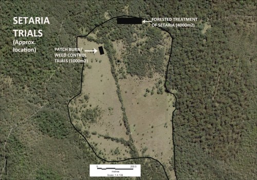
Figure 1. Aerial view of the Setaria-dominated clearing at Minyuma IPA prior to restoration work . The trial area arrowed is the location of the preliminary trial of herbiciding plus fire followed by regular spot spraying of weed regrowth. The project was then expanded to much of clearing to the left of the artificial drain running through the centre of the site (Photo Minyuma IPA)

Introduction. ‘Minyumai’ is an approx. 2000ha property owned by Minyumai Landholding Aboriginal Corporation (MLHAC) and managed by the MLAC board and the Minyumai Rangers. The property is located on the far north coast of NSW, adjacent to Bundjalung National Park and Tabbimoble Nature Reserve and was dedicated as an Indigenous Protected Area (IPA) in 2011. 

The property is largely comprised of native ecosystems, including five Endangered Ecological Communities (EECs), however it has a history of grazing in largely three sizeable clearings.  The largest and most degraded of these clearings (the ‘middle clearing’) (Figs. 1 and 2) became known to the Rangers as the ‘Setaria plots’ as it was almost completely devoid of trees, was dominated by the introduced pasture grass Setaria (Setaria sphacelata) and was subsequently divided into multiple plots for treatment and monitoring.
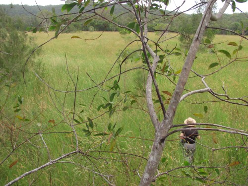
Figure 2. Closer view of the density and cover of Setaria at the site prior to treatment. (Photo Minyuma IPA)

The purpose of the work in the Setaria plots is to convert the vegetation from weed dominance to dominance by native species of the site’s prior ‘Swamp sclerophyll forest on coastal floodplains’ EEC. The project started in 2014 and is an ongoing part of the Ranger’s regular works program. 

Works undertaken. After a successful trial sponsored by Firesticks in an adjacent area, a facilitated natural regeneration approach was adopted in the Setaria plots, supplemented by some tree planting. While there were little or no above-ground natives evident among the mature Setaria at the start of the project (Fig 2), the Firesticks trial showed that the use of fire followed by precision weed spraying would result in at least some regeneration of native ground covers from the soil seed bank.
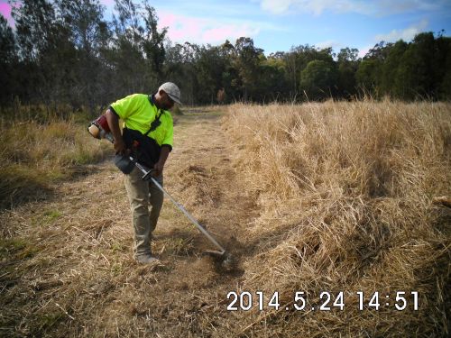
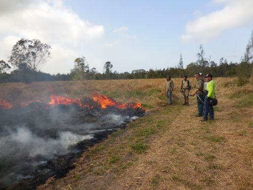
Figure 3. Firebreaks were installed at the site prior to spraying and burning and remain maintained to allow for ongoing use of fire during over time should it prove beneficial. (Photo Minyuma IPA)
Figure 4. Minyumai Rangers and visitors from a neighbouring IPA running a burn on the site. (Photo Minyuma IPA)

The plot-by-plot approach subsequently adopted involved creating firebreaks, overspraying the mature setaria with 1% glyphosate and subsequent burning of the dried weed biomass (Figs 3 and 4).  Subsequent follow-up spot-spraying was then systematically and regularly carried out.

Monitoring.  The project offered an opportunity to separate and compare burn and spray treatments with spray-only treatments – i.e.  all plots (except untreated controls) were subjected to systematic weed management but some were additionally burnt.  Species counts and cover was measured at 2 years of age and again at 4 years of age – with the ground stratum monitored using 15 quadrats (7 burn+spray, 6 spray only and 3 controls) and woody cover monitored using 18  (20m) transects (line intercepts).

Figure 5. Photopoint monitoring showing changes at the site over a 3 year period showing treatments and gradual regeneration of natives. (Photos Minyuma IPA)

Results to date.  While the initial follow up treatments revealed extensive weed, this rapidly transitioned to native dominance over time (Fig 5) and with fairly rigorous herbicide treatment of all weed by the Rangers.  The site developed high levels of cover within 18 months. A total of  37 native species were recorded over the four years (including 5 trees, 2 shrubs,  1 vine, 18 forbs, 7 sedges and 4 grasses) .  A total of 26 weed species (1 shrub, 14 forbs, 2 sedges and 9 grasses) occurred and while weed cover reduced over time ) most species of weed remained present in the system.  

The quadrat data showed that the fire plus spot-spraying treatment resulted in improved native cover in the ground stratum (scoring an average of 3.38 on a 5 level cover scale)  compared to spot-spraying alone (scoring an average of 2.17 on the 5-level cover scale) with the controls remaining in the lowest cover level.

Transect monitoring of woody species cover over time showed a significant increase in tree cover after both fire plus spray (n=5)  and spray alone (n=9) treatments compared to the untreated controls (n=4) but there was no significant difference between the burn plus spray and spray only  treatments, which is understandable as none of the tree species form soil seed banks.
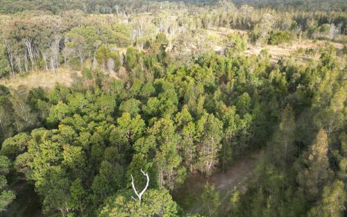
Figure 6.  Drone photo of the same quadrats from the air in August 2023, nine years after the work commenced. The dense green tree growth in the middle of the photo is all regrowth on the treated plots. Between this area and the intact Paperbark forest in the further distance there is a band of untreated land still dominated by Setaria and without native colonisation. (Note the Eucalypt circled is the same Eucalypt in the right hand background of the photos in Figure 5.)   (Photo G. Little)

Changes over time. The sedges, which were initially abundant in the understorey,  became less abundant over the two readings. Native grasses were initially far less common but increased over time, and 10 years on are still far less prevalent than sedges, which makes sense considering the wetland nature of the site.

Some  forbs, such as Buttercups (Ranunculus spp.), Gotu Kola (Centella asiatica), Pennyworts (Hydryocotyle spp.), Kidney Weed (Dichondra repens) and Native St Johns Wort (Hypericum perforatum) became frequent or abundant and remained so over the monitoring period. while other forbs such as Grass Lily (Murdannia graminea), Ludwigia (Ludwigia and Native Bluebell (Wahlenbergia sp.) remained uncommon or even rare.

Over the 10 years since the project began, the tree species Swamp Box (Lophosptemon suaveolens), Swamp Oak (Casuarina glauca) and Broad-leaved Paperbark (Melaleuca quinquinervia) have all become markedly more abundant over time through colonisation from the surrounding forest (Fig. 6) – with natural regeneration far outweighing any tree planting efforts made at the start of the project.  Forest Red Gum (Eucalyptus tereticornis) did not however increase from the remnant tree on site nor did planted seedlings of this species survive.   

Lessons learned and future directions.  When comparing the treated areas with untreated areas it is clear that the native tree colonisaton is confined to the treated areas. Although the treated areas developed high native herbaceous cover it is likely that the open niches created by the weed control and fire allowed colonisation by trees, while the dense Setaria cover prevented regrowth. 

A major challenge has been the presence of wild cattle on the property that have proved resistant to capture. This required electric fencing of the site for some years to avoid damage to plantings, although natural regeneration has now overtaken the plantings.

Critical to success was rigorous follow up prior to the weed reseeding.  Complete avoidance of reseeding was not always possible due to funding limitations or personnel changes. This has resulted in some reinvasion of Setaria in some of the plots, although the Rangers continue to manage the site well. 

As the mown firebreaks are still in place, there is potential for cool fire to be reintroduced into the site (followed by further weed control) should this be considered ecologically beneficial.  The site may also benefit from a project (being conducted in collaboration with Nature Glenelg Trust) to fill in the artificial drain visible in Fig 1.

Stakeholders and Funding bodies.  We acknowledge the valuable contributions of all the Minyumai IPA Rangers, particularly the early leadership of Minyumai Rangers, Daniel Gomes, Justin Gomes and Belinda Gomes. The Commonwealth Government’s IPA program funded the delivery of biodiversity management services by MLHAC, and funding and advice for the fire trials was provided by the NSW Nature Conservation Council’s  Firesticks initiative, with advice from Oliver Costello and Richard Brittingham. Tein McDonald advised on techniques and monitoring and Andrew Johnston provided training for the Minyumai Rangers in the first years of the project.

Contact: Mary Wilson, Minyumai Land Holding Aboriginal Corporation. Email: <admin@minyumai.org.au>

Shorebird habitat restoration in the Hunter Wetlands National Park

By Tom Clarke

Figure 1. Contractors felling mangrove trees to restore migratory shorebird habitat structure at Stockton Sandspit.

Introduction. Thirty-seven species of migratory shorebirds regularly visit Australia, with all but one spending up to 6 months of each year here. Globally, populations of some migratory shorebirds have declined by 80% over the last 30 years largely due to habitat destruction and disturbance along the East Asian-Australasian Flyway. Within Australia, degradation of feeding and roosting habitats and disturbance are the major threats. Shorebirds need access to safe roosting places. Typically, a favoured roost is close to feeding areas, has a wide-open space and a clear view of the water. A clear view is needed for predator avoidance. A major issue for shorebirds in the Hunter Estuary, indeed for the entire flyway, is having access to several roosts so that alternative sites are available when conditions and levels of disturbance become intolerable at the preferred roost.

In the late 1990s it became obvious that vegetation encroachment was degrading major roost sites in the Hunter Estuary. Of particular concern was the viability of Stockton Sandspit, a shorebird roost site of national importance. Mangrove encroachment along the beachfront was creating a wall of vegetation and effectively blocking the view of the water. Woody weeds were also encroaching on the roost area resulting in a large decline in shorebird numbers using the roost site.

Mangrove encroachment has been documented in several estuaries along the east coast of Australia. Halting encroachment is not an option but managing specific areas that are important for shorebirds is achievable. This project involves the removal of mangroves adjacent to favoured roosting sites to maintain low, open spaces with a clear view of the water, with the intent of maintaining the sites  for shorebirds as long as they keep turning up. The potential recovery of coastal saltmarsh in these sites is an added bonus as saltmarsh is an endangered ecological community.

Figure 2.  Main shorebird habitat restoration sites in Hunter Wetlands National Park.

Works undertaken. Mangroves are normally protected vegetation by law. After it was agreed by various stakeholders that mangroves should be cleared from Stockton Sandspit, a permit to remove mangroves was applied for from Department of Primary Industries (Fisheries). The initial permit allowed for the removal of mature mangroves from an area of less than 1 hectare. This primary work was carried out by contractors (Fig. 1). The funding agreement required matching volunteer effort. Initially, volunteer work involved Hunter Bird Observer’s Club (HBOC) monitoring the shorebirds, but this was quickly augmented by on-ground work to remove woody weeds (including Lantana Lantana camara, Bitou Bush Chysanthemoides monilifera ssp. rotundata and Telegraph Weed Heterotheca grandiflora) and reduce the density of native shrubs (including Acacia spp, Banksia spp. and Leptospermum spp.) from the roost area. Weeding also aimed to remove exotic rushes from a small area of saltmarsh. Following initial success, other shorebird roost sites in the Hunter Estuary with similar threats were added to the program (Fig. 2). These additional areas were selected using data from the shorebird monitoring being conducted by HBOC. At each site, an initial primary effort by contractors is followed up by HBOC volunteers and others. The project has been running continuously since 2002 and represents the HBOC commitment to caring for these endangered birds.

Over 10,900 volunteer hours has been accrued to date through the efforts of over 480 persons and the program is ongoing. Today, the project maintains nearly 150 hectares of shorebird habitat in Hunter Wetlands National Park. From March through to July each year, a program of works is scheduled to take advantage of favourable tides to access work areas. These cooler months are better for working in exposed areas and are when the population of migratory shorebirds is at its lowest. Removal of mangrove seedlings takes up most of the ongoing volunteer effort (Figs 3-6). The level of recruitment of mangrove seedlings varies from year to year and site to site. Factors such as tide height, wind direction and flood levels at the time of seed-drop affect the distribution of the seeds. Seed-drop usually occurs from the end of August through to early November with the majority falling through September. However, over the eighteen months of wet weather following the prolonged drought that ended in early 2020, mangrove seeds were washing up every month of the year. This required a massive effort to clear mangrove seedlings from all the sites in 2022. Thankfully the effort required in 2023 was back at a sustainable level.

Figure 3. Intrepid Landcarers cutting mangroves on Smith Island. (Photo T. Clarke)

Figure 4. Volunteers sweeping the marshes at Stockton Sandspit. (Photo T. Clarke)

Results to date. Removal of fringing mangroves and woody weeds from the roost area had an immediate positive effect. Most of the shorebirds quickly re-occupied Stockton Sandspit. This continues to be the case with Stockton Sandspit being one of the main daytime roosts used in the Hunter Estuary. Similar success has occurred at other sites but has not been quite as outstanding. These sites tend to be used by smaller aggregations of birds but are complementary to the Stockton Sandspit as different shorebird species prefer them. Some of the additional sites are frequently used as back-up roost sites when the preferred site is suffering unusually high levels of disturbance, often due to human activity.

Figure 5. Final sweeps over Milham Pond by Hunter Bird Observers Club volunteers in 2022. (Photo T. Clarke)

Figure 6. Mass drop of mangrove seeds happens every year at Stockton Sandspit and other places. Six months later the surviving seedlings are removed by volunteers. (Photo T. Clarke)

Lessons learned and future directions. Working on the inter-tidal areas has required that we develop an understanding of how the estuary system operates. In the early years lots of tide notes were collected for each site as well as shorebird movements. Utilising favourable tides gives better access and improves efficiency. Understanding certain shorebird behaviours also improves our efficiency. Quite often, a couple of forward scouts in the form of godwit or curlew will fly over a roost site on an inspection loop prior to the main rush of the various flocks. This is the signal for workers that it is time to vacate the site.

Many techniques and a variety of hand tools have been trialled with differing levels of success. Hand-pulling the seedlings has proven to be the most efficient. We have found that it is possible to manage the mangroves without the use of chemicals. Cutting stems lower than the next high tide results in the stumps being immersed and the tree dies. This also works for seedlings that are snapped-off. In situations where the substrate is firm enough, seedlings can be snapped off at ground level using a hoe. However, this method doesn’t work in soft mud as the plant bends away rather than breaking. Where seedling recruitment is dense, a battery-powered brush cutter has been utilised. This method was very useful during the year of continuous seeding.

While the initial work was motivated by a sense of obligation to intervene, the ongoing work provides positive feedback that maintains the energy and brings much satisfaction to the carers. This happens on every occasion that we witness the arrival of the shorebirds to the places that are restored each year, a positive joy. Maintenance of the various roost sites has become a wonderful opportunity to introduce people to shorebirds.

Stakeholders and funding bodies. At each stage of the project an initial effort of primary works was carried out by contractors and funded through various Government programs including the Australian Government’s Caring for Our Country, Envirofund and Threatened Species Recovery Fund.   The following have supported the works in some manner over the last twenty years; Twitchathon, Bird Interest Group Network (BIGNet), Birdlife Australia,  Conservation Volunteers Australia, the NSW Departments of Primary Industries and Fisheries, and Planning and Environment (and their predecessors), Hunter Bird Observers Club, Hunter Catchment Management Authority, Hunter Local Land Services, Hunter Regional Landcare Network, Kooragang Wetlands Rehabilitation Project, NSW National Parks & Wildlife Service, Newcastle Kayak Tours, Newcastle City Council, Newcastle Coal Infrastructure Group, NSW Government, Toolijooa, Trees In Newcastle, University of Newcastle.

The volunteer effort has been led by members of HBOC that make up the core team. Additional contributions have been made from other groups from time to time including: Better Earth Teams, Green Army, International Student Volunteers, TAFE students, Koora Gang, Intrepid Landcare, Worimi Green Team, Stockton Scouts, Raymond Terrace Scouts, Al Gazzali and Rigpa Buddists.

Contact information. For more information contact Tom Clarke thomas.clarke7@bigpond.com and project reports can be viewed on the HBOC website Rehabilitation Projects – Hunter Bird Observers Club (hboc.org.au).

Rewilding lake edges at Sherwood Arboretum, Queensland

Carole Bristow

Figure 1. The site in 2014, 5 years prior to works, showing the lack of wetland fringing vegetation due to it being regularly brushcut. (Photo Friends of Sherwood Arboretum)

Sherwood Arboretum, 15 hectares in size, contains a collection of planted (specimen) Queensland native trees under the supervision of Brisbane Botanic Gardens. Located in the suburb of Sherwood in Brisbane, the Arboretum has the Brisbane River as its western boundary and there are three small watercourses running both into and out of two lakes, providing habitat for wildlife. Before the development of the Arboretum in 1925, the lakes were a single paperbark swamp with small patches of open water. An early city water main ran across the swamp roughly dividing it in two. In 1975 the water main was covered by rocks and soil to form a causeway/walking path, and the swamp was reshaped to form two open lakes containing three islands. Many species of birds use the lakes, the watercourses, and the Arboretum as a whole, gathering and dispersing according to season or changes in management.

Prior to the commencement of regeneration treatments the edges of the lake were relatively barren (Fig 1), kept in this condition by regular mowing and brushcutting which led to occasional collapses of the edges into the lake.  Close inspection found around 14 natives among the weeds being mowed and brushcut; so the idea came that perhaps the natives could be allowed to grow and protect the edge.  This would also form a natural plant community and potential faunal habitat. Twenty weed species were observed, including Signal Grass (Brachiaria decumbens), Green Panic (Megathyrsus maximus var. pubiglumis), Bahia Grass (Paspalum notatum), Slender Pigeon Grass (Setaria parviflora), Blue Couch (Digitaria didactyla), Blue Billy Goat Weed (Ageratum houstonianium), Creeping Indigo (Indigofera spicata).

Works undertaken. In 2019, agreement was reached to discontinue mowing to the edge and brushcutting, and to trial bush regeneration-style weed management along a manageable portion of the lake edge; that is, both sides of the causeway.  The work was carried out by two members of the Friends of Sherwood Arboretum bushcare group, a Habitat Brisbane bushcare group which is supported by Brisbane City Council.   The two volunteers worked on a weekly basis over 4 years, gradually removing weeds to release native plants.  The technique involved weed removal prior to weed seed shed while allowing natives to seed.  The objective was to reduce weed soil seed banks and recharge native soil seed banks over time.

Figure 2. The north-west corner of the causeway in 2021 showing high density natives, particularly Willow Primrose. (Photo Gordon King)

Results to date. As weed cover declined markedly, natives increasingly reappeared, dominating the site within two years.  At the peak of the site’s recovery, 34 native wetland herbaceous species had returned – many of these in high abundance in particular locations Figs 2-7).  These particularly included Tassle Sedge (Carex facsicularis), Emu Foot (Cullen tenax), Narrrow-leaved Indigo (Indigofera linifolia), Common Rush (Juncus usitatus), Willow Primrose (Ludwigia octovalvis), Slender Knotweed (Persicaria decipiens), Spotted Knotweed (Persicaria strigosa) and Poison Pratia (Lobelia concolor).

Water birds that also graze on land have been observed by the regeneration team to be increasingly using the lake edges – including Purple Swamphen (Porphyrio melanotus), Wood Duck (Chenonetta jubata) (Fig 6), Dusky Moorhen (Gallinula tenebrosa) and Intermediate Egret (Ardea intermedia).  The wetland plant insect life has also increased in the recovered areas.  As a result, the Chequered Swallowtail Butterfly (Papilio demoleus) (Fig. 7) is now seen among the Emu Foot, one of its host plants.

Figure 3. General view with White Eclipta (Eclipta prostrata), Slender Knotweed, Willow Primrose, Commelina (Commelina sp.) and Azolla (Azolla sp.) (Photo Gordon King)

Figure 4. Emu Foot. One of the natives tenaciously surviving even when there was a heavy weed presence. (Insets are of the characteristic five leaflets and the inflorescence.) (Photos Gordon King.)

Figure 5. Diversity of native species is high in some places – such as pictured here where Willow Primrose, Common Reed, White Eclipta, Binung (Christella dentata), Sprawling Bluebell (Wahlenbergia gracilis) and Emu Foot occur in close proximity. The waterlily is the introduced Mexican Waterlily (Nymphaea mexicana) and is controlled from time to time. (Photo Gordon King)

Figure 6. Wood Ducks foraging along the regenerating lake edges. (Photo Gordon King)

Figure 7. Insect life has increased including the Chequered Swallowtail butterfly for which Emu Foot is a host plant. (Photo Gordon King)

Changes over time. Composition has proven to be seasonally variable. At one point when the water had reduced to a very low level in the lake, muddy edges appeared, and Bacopa (Bacopa monniera.) emerged and flowered. A few days later there was rain and the water rose and covered the flowering plants – which are unlikely to return until muddy edges reappear. More recently, with heavy rains in February 2022, floodwaters covered all the banks to a depth of over 1m for several days.  Many species were severely affected, particularly Willow Primrose.  However a good recovery of all species is occurring.

A notable result of the work has been that the lake edges are no longer eroding and it is clear that valuable new habitat has been created.  These results provide more positive options for future management of the more extended lake edge should habitat restoration be undertaken in the future. It is an inspiring project to be involved in.

Acknowledgements: Brisbane Botanic Gardens and Brisbane City Council Habitat Brisbane program for agreeing to try this process. The Habitat Brisbane program also helped with occasional contractor support. Also thanks are extended to Gordon King, for his unflagging effort as fellow worker and for the use of his photographs.

Contact: Carole Bristow, bushcare leader, Friends of Sherwood Arboretum bristowc@bigpond.net.au

Lake Bolac Eel Festival and Environmental Forum – 25-26 March 2022

Figure 1. An Environmental Forum is a held at each Lake Bolac Eel Festival to bring to the festival-goers reliable information about the ecology of the region and its potential for improved management. (Photo Tein McDonald)

Introduction. Cultural events are increasingly recognised as critical to cultural change and community awareness building. One outstanding example is the Lake Bolac Eel Festival (Kuyang Lapakira – Plenty Eels), a biennial festival held at Lake Bolac in the western basalt plains of Victoria to celebrate environmental repair and Aboriginal cultural revival (Figs 1-5).

The timing of the festival reflects the season when Kuyang (Shortfinned Eel, Anguilla australis) begins its migration to the sea to spawn and when the First Nations Communities from surrounding areas gathered to harvest the species, trade and hold ceremonies. As such the festival is a significant gathering place for people who care for the environment and respect Aboriginal cultural heritage, promoting the restoration of Lake Bolac and surrounding waterways.

Figure 2. The 2022 Eel Festival’s Welcome to Country was conducted by Traditional Owner Brett Clarke with the assistance of local Indigenous community members. The Festival is a gathering of new generations of people affirming the traditions of past generations who cared for the lands and waters of the Lake Bolac area. (Photo Ayesha Burdett)

Figure 3. The festival is very small but is attended by many locals and those serious about ecological and cultural restoration. In 2022, workshops on topics including tanning Eel leather, Indigenous tools and song-making, and childrens’ craft activities were interspersed among music and dance events. (Photo Tein McDonald)

An Environmental Forum is a regular part of each festival program. At this year’s forum, chaired by freshwater wetland ecologist Michelle Casanova, six presenters including Traditional Owners, Glenelg Hopkins Catchment Management Authority representatives, the local Landcare group, local landholders and researchers provided rich information about the significance of the site, the eel and its habitat,  management strategies, and roles of stakeholders.

The Forum commenced with a moving Welcome dance and a smoking ceremony led by Traditional Owner Brett Clarke. The first speakers were Tim Hill and Jileena Cole, Chair and Facilitator respectively from the Beyond Bolac Catchment Action Group, who described the context of the efforts to protect and repair eel habitats in a production landscape. Brett Clarke then spoke movingly on the role of First Nations people caring for Country and culture. The third speaker was Greg Kerr, Senior Ecologist with Nature Glenelg Trust, who focused on exploring the idea of ‘home’ for animals in Lake Bolac, while the fourth speaker, John Sherwood from Deakin University, intrigued the audience with his presentation on recent evidence of the Moyjil archaeological site at Warrnambool Victoria that suggests far earlier habitation of Victoria by Aboriginal people than is conventionally understood.

Damein Bell – member of the Gundtijmara community, CEO of Gunditj Mirring Traditional Owners Aboriginal Corporation and currently a Board Member with the Glenelg Hopkins Catchment Management Authority – spoke engagingly on the long effort to have the Budj Bim Cultural Landscape recognised on the UNESCO World Heritage List in July 2019. This account reinforced the importance of patient and persistent action to effect social change.

Perhaps the most intriguing talk was the presentation by the sixth speaker, Wayne Koster from the Arthur Rylah Institute (DELWP) who regaled us with what is currently known about the migration of the Short-finned Eel. This species is native to the lakes, dams and coastal rivers of south-eastern Australia, New Zealand, and much of the South Pacific, but very little has been historically known about its reproduction or where this takes place. Preliminary results were presented of Waynes’s recent work satellite tracking oceanic migrations of the Short-finned Eel, with migration track to the Coral Sea between New Caledonia and Australia.

Figure 4. The large tent provides the setting for both the Environmental Forum and the later musical events. (Photo Tein McDonald)

Figure 5. The day’s activities culminated in a Twilight ceremony featuring Aboriginal dancers, followed by a concert headlined by local musician and one of the Festival founders, Neil Murray. ( Photo Una Allender).

Stakeholders: The event is managed by the Lake Bolac Eel Festival Committee. Funders include: Grampians Pyrenees Primary Care Partnership, Victorian Regional Arts Fund Community Grants Round 2 2019, Ararat Rural City Council; Regional Arts Victoria, Beyond Bolac Catchment Action Groups, Stronger Communities Programme Round 7 – Wannon, Visit Victoria – Regional Community Events Fund, Glenelg Hopkins CMA, Willaura Lake Bolac Community Bank and NBN Local.

Contacts: Una Allender <uallender@bigpond.com> or Ayesha Burdett <ayesha.burdett@gmail.com> Lake Bolac Eel Festival Committee.  Media contact: Sally Gibson <sgibsonaustralia@gmail.com>

Regeneration of indigenous vegetation at Third Reedy Lake as it has dried over summer and autumn 2022

Damien Cook

Introduction.  Third Reedy Lake is a freshwater wetland in the Kerang region in north central Victoria. It is part of the Kerang Wetlands Ramsar Site, which means that it is recognised as being of international significance for wetland conservation as it supports threatened plant and animal species and ecological communities and rookeries of colonial nesting wetland birds.

Prior to European occupation this wetland, along with Middle Lake and Reedy Lake, would have been inundated only when floodwaters came down the Loddon River and caused the intermittent Wandella and Sheep Wash Creeks to flow. At that time the wetland experienced a natural wetting and drying cycle, filling up from floodwaters and drying out completely between floods, which occurred on average once every 3 to 4 years.

In the 1920s, however, this natural wetting and drying cycle was discontinued. Third Reedy Lake became part of the Torrumbarry Irrigation Scheme. Water was diverted out of the Murray River at Torrumbarry Weir and made to flow through a series of natural wetlands including Kow Swamp, the Reedy Lakes, Little Lake Charm and Kangaroo Lake to deliver water to irrigate farms. The lakes and swamps became permanently inundated.  While this meant farmers had a reliable supply of water it also profoundly altered the ecology of the wetlands (Fi. 1).

Figure 1. Third Reedy Lake in February 2013 prior to being bypassed. Continuous inundation for around a century had drowned the native vegetation, leaving only skeletons of trees. (Photo D. Cook)

Trees such as River Red Gum (Eucalyptus camaldulensis) and Black Box (E. largiflorens) were drowned, lake bed plants that relied on a drying cycle could no longer grow and the ecological productivity of the wetlands was massively reduced. The density of wetland birds has been found to be positively correlated to wetland productivity and this metric has been used in a variety of ecological studies to compare the use of different habitats by wetland birds. During bird counts conducted in 2018 the highest density of birds on Third Reedy Lake was about 5 birds/hectare. In contrast the naturally intermittent Lake Bael Bael supported over 60 birds/hectare, a density 12 times higher. While Third Reedy Lake supported a maximum of 17 wetland bird species Lake Bael Bael supported a maximum 38 wetland bird species.

Works undertaken

Hydrological works.  Third Reedy Lake was deemed to be inefficient for moving water due to losses caused by evaporation and so it was intentionally bypassed by the irrigation scheme in 2020. The lake therefore dried for the first time in one hundred years over the summer of 2022. Environmental water will be periodically delivered to the wetland in the future to mimic its natural wetting and drying cycle and assist ecological recovery.

Revegetation works. Over 2000 River Red Gum trees and 1000  understorey plants, including Tangled Lignum (Duma florulenta) and Southern Cane-grass (Eragrostis infecunda), have been planted across the centre of the lake where no natural regeneration was likely to occur in the short to medium term. Members of the local Barapa Barapa and Wemba Wemba Traditional owner communities were employed to plant the trees and other plants (Fig. 2). The Barapa Barapa and Wemba Wemba Traditional Owners have a strong interest in the wetland because of its cultural values.


Figure 2. Uncle Trevor Kirby with a Red Gum he has just planted and guarded at Third Reedy Lake April 2022. . Virtually no native vegetation remained visible on the lake bed immediately after the long inundation. (Photo T. McDonald)

The River Red Gum seedlings have been planted next to dead River Red Gum stumps to replicate the original woodland structure of the wetland (Fig  3). Planting next to the stumps has other advantages; they provide shelter from the wind and sun and soil carbon and moisture levels are highest close to the rotting wood.

Figure 3. River Red Gum seedling planted next to an old red gum stump, Third Reedy Lake May 2022. (Photo D. Cook)

Results to date.  In the first 3 months without inundation the lakebed muds dried out, followed by deep cracking (Fig 2). Planted trees thrived as there was still ample moisture in the sub-soil.  Site inspections in May 2022 revealed that substantial natural regeneration of the wetland has begun (Fig. 4).

After 100 years without drying it was not known if any seed bank of the original lakebed vegetation would have survived. However, 46 native species have been recorded growing on the lakebed since the last of the water evaporated from the lake in April 2022. This includes two threatened species: Floodplain Groundsel (Senecio campylocarpus) and Applebush (Pterocaulon sphacelatum) (Fig. 5) . The germination of Applebush is particularly surprising given that this is only the fourth record of this plant in Victoria, the species being more common in the arid centre of Australia. Other indigenous species that have regenerated on the lakebed are shown in Figs 6 and 7.

Figure 4. Lake bed herbs regenerating after the drying phase, at Third Reedy Lake, May 2022 . A total of 46 native species have been recorded as having regenerated on the lakebed since the last of the water evaporated from the lake in April 2020 (Photo D. Cook)

Figure 5. Among the 46 native species regenerating is Applebush (Pterocaulon sphacelatum) which is particularly surprising as it is listed as endangered in Victoria and known to occur in only three other locations. (Photo Dylan Osler)

Figure 6. Spreading Nut-heads (Sphaeromorphaea littoralis), Third Reedy Lake May 2022. This species is uncommon in the Kerang region, the closest records to Third Reedy Lake being from the Avoca Marshes. (Photo D. Cook)

Figure 7. Golden Everlasting (Xerochrysum bracteatum) and Bluerod (Stemodia florulenta) make an attractive display of wildflowers. These species are uncommon at present but if weeds are controlled adequately, they should recolonise much of the wetland floor. (Photo D. Cook)

River Red Gum regeneration has been localised on the bed of the lake and has mainly occurred on the fringes close to where living Red Gum trees have shed seed. The densest Red Gum regeneration has occurred on a sandy rise close to the inlet of the lake, where the trees have grown rapidly (Figs 8 and 9). Many of the seedlings that have germinated on the edge of the lakebed are being heavily grazed by rabbits or wallabies.

Figure 8. Regenerating Red Gums and native grasses and sedges on a sandy rise near the inlet of Third Reedy Lake, May 2022.(Photo D. Cook)

Figure 9. River Red Gum seedling on cracking clay soil that has germinated near the lake edge. Many of these seedlings are being heavily grazed, probably by rabbits or wallabies. (Photo D. Cook)

The young trees will take many years to develop the hollows required by many species of wildlife, but hopefully the old stumps will persist for some time to provide this important habitat feature (Fig 10). When these trees grow large enough, they will provide shady nesting sites for colonial nesting wetland birds such as Australasian Darter (Anhinga novaehollandiae) (Fig. 10) and Great Cormorant  (Phalacrocorax carbo) and replace the dead standing trees as they rot and fall over.

Figure 10. Australasian Darter chicks on a nest in a live River Red Gum in the creek that joins Middle Lake to Third Reedy Lake. (Photo D. Cook)

Stakeholders: Barapa Barapa, Wemba Wemba, Goulburn-Murray Water, North Central Catchment Management Authority and Kerang Wetlands Ramsar Site Committee

Contact:  Damien Cook, restoration ecologist, Wetland Revival Trust, Email: damien@wetlandrevivaltrust.org

The Role of Swamps in Drought: Popes Glen Creek, Blackheath

Alan Lane

Introduction

The important role of swamps in water storage and as regulators of stream flow has been well documented (10.1016/j.geomorph.2018.03.004). Previous EMR project summary reports on Popes Glen Creek, Blackheath, have described the establishment of a swamp on the former highly degraded and weed-infested silt plug at the headwaters of the creek.  (See links at end of this summary.)  That 18-year long project has been documented in “The Full Story”, https://dl.bookfunnel.com/ebgais2pxn and an 8-minute summary video can be viewed at https://www.youtube.com/watch?v=610sas330EQ

The recent severe drought in New South Wales provided the opportunity to monitor the water table in this swamp in the absence of rain and compare the impact on the swamp vegetation with that on more elevated and drier slopes nearby.

How we measured the water table. Six piezometers were installed at the start of this rehabilitation project, located about 50 m apart and midway between the edges of the long, rectangular silt plug. These went down to the bedrock, at depths of between 113 and 152 cm and were used to monitor water table depth and also for sampling water quality and stygofauna.

What we found. During periods of normal or above average rainfall (e.g. September 2019), the water table at each of these bore holes was typically at the depth below soil surface shown in Table 1.

Levels fell almost to bedrock during the drought (Oct 2019 – Dec 2019), before recovering after rains in January and February 2020 (Tables 1, 2). 

Table 1. Water table depths during normal and below-average rainfall periods.

Bore hole number
Depth below surface (cm) 1 2 3 4 5 6
Normal rainfall period (Sept 2019) 31 2 7 11 23 9
After drought period (Dec 2019) 103 106 121 103 123
After recovering rainfall (Feb 2020) 29 0 12 21 13

Table 2.  Rainfall, October 2019 – February 2020.

Month Rainfall (mm)1 5-year average (mm)2 % of average
September 2019 81.4 53.6 151.6
October 2019 23.8 76.7 31.0
November 2019 26.4 82.2 32.1
December 2019 0.4 69.5 0.6
January 2020 99.2 127.9 77.6
February 2020 560.4 183.6 305
  1. From Bureau of Meteorology, Mount Boyce, NSW
  2. From willyweather.com.au, Mount Boyce, NSW

During this period of extreme drought, the vegetation on the slopes above the Popes Glen swamp manifested extreme water stress in a way never before seen (Figs. 1, 2). Many of these extensive expanses of Coral Fern (Glycaenia dicarpa), stands of Fishbone Water Fern (Blechnum nudum) and individual Black Tree Fern (Cyathea australis) plants have not recovered and now appear unlikely to do so.

Figure 1. Expanses of severely water-stressed Glycaenia dicarpa on slopes above the Popes Glen swamp.

Figure 2. Many of the Blechnum nudum and Cyathea australis on slopes above the swamp have failed to recover.

In marked contrast, the vegetation in the swamp area (Fen Sedge (Carex gaudichaudiana), Tassel Sedge (Carex fascicularis), Tall Spikerush (Eleocharis sphacelata) and Juncus sp.) remained lush and vigorous (Fig. 3), suggesting it was sustained by the supply of water retained in the substrate.

This supply was progressively depleted during the drought and the water table had fallen almost to bedrock before the rains in January (Tables 1, 2).

Figure 3. Vegetation in the Popes Glen swamp remained lush throughout the drought.

Implications. It seems inevitable that this water supply would have been completely exhausted had the 2019-2020 drought lasted longer. Temperate Highland Peat Swamps on Sandstone (THPSS), including the Popes Glen swamp, appear threatened by the even more prolonged droughts anticipated as climate disruptions due to global heating become more marked.

Acknowledgements. This work was supported by Blue Mountains City Council and funding from the Environmental Trust of NSW.

Contact. Alan Lane alanlane388@gmail.com

See also EMR Project Summaries:


Ecological restoration in urban environments in New Zealand – UPDATE of EMR feature

Bruce Clarkson, Catherine Kirby and Kiri Wallace

[Update of EMR feature  – Clarkson, B.D. & Kirby, C.L. (2016) Ecological restoration in urban environments in New Zealand. Ecological Management & Restoration, 17:3, 180-190.  https://onlinelibrary.wiley.com/doi/10.1111/emr.12229]

Key words: urban ecology; restoration; indigenous biodiversity; New Zealand

Figure 1. Kauri dieback disease is affecting individual trees (left). [Photo Nick Waipara]

Introduction. Our 2016 EMR feature reviewed the state of research and practice of ecological restoration in urban environments in New Zealand. We concluded that urban restoration can influence and support regional and national biodiversity goals. We also observed that research effort was light, lacking interdisciplinary breadth and may not be sufficiently connected to restoration practice to ensure long-term success of many projects.

While it is only three years since that review was published, urban ecological restoration continues to grow and evolve, and the policy setting and political context have changed significantly. New threats and opportunities have emerged. The spread of a dieback disease and the more recent arrival of myrtle rust, rapid uptake of Predator Free 2050, emergence of the One Billion Trees programme, a surge in housing and subdivision development, and a potentially more supportive policy framework are all major factors.

Threats and opportunities. Kauri dieback disease is severely affecting urban kauri forests and individual Kauri (Agathis australis) trees in Auckland and other northern North Island urban centres (Fig. 1). Large forest areas adjoining Auckland, including most notably the Waitākere Range and large parts of the Hunua Range, are now closed to the public, preventing access to popular recreational areas. The dieback is caused by a fungus-like pathogen Phytophtora agathicida that is spread through soil movement. The disease may have arrived from overseas although this is uncertain. There is no known cure but research efforts are underway to find a large-scale treatment option.

Myrtle rust (Austropuccinia psidii) was first found on mainland New Zealand in May of 2017, probably arriving by wind from Australia. Myrtle rust threatens many iconic New Zealand plant species in the family Myrtaceae including Pōhutukawa (Metrosideros excelsa), Mānuka (Leptospermum scoparium), Rātā (Metrosideros robusta), Kānuka (Kunzea spp.), Waiwaka (Syzygium maire) or Swamp maire, and Ramarama (Lophomyrtus bullata). These species are all used to a greater or lesser extent in restoration planting or as specimen trees or shrubs in urban centres, depending on amenity or ecological context. Mānuka is widely used as a pioneer or nurse crop for native forest restoration and is critical to the economically important mānuka honey industry. Waiwaka is a feature of many swamp forest gully restoration projects in Hamilton and this would be a significant setback if they were badly affected. The impact of myrtle rust is still not clear but experience from Australia suggests it may take several years before it reaches population levels sufficient to cause significant damage.

Figure 2. With rapid housing developments in New Zealand, it is important that urban restoration projects are well-planned and efficiently carried out to provide residents with greenspaces to benefit their cultural, health and wellbeing practices. [Photo Catherine Kirby]

In response to a range of housing issues characterised by many as a New Zealand housing crisis, the previous and current government has embarked on several major initiatives to increase the housing stock. A $1B Housing Infrastructure Fund (HIF) was established in October 2016 with provision for interest free loans to local government to enable opening up of new large areas of housing. Many urban centres including Auckland, Tauranga, Hamilton and Queenstown made early applications to the fund. Hamilton City Council was successful in obtaining $290.4 M support for a new greenfield subdivision in Peacocke on the southern edge of the city. This subdivision is intended to enable development of some 3700 houses over the next 10 years and 8100 in 30 years. Approximately 720 ha of peri-urban pastoral agricultural land would eventually be developed (See summary). Coupled with this, and already in progress, is the construction of the Southern Links state highway and local arterial road network. The first proposed subdivision Amberfield covers 105 ha and consent hearings are currently in progress. The environmental impacts of the proposal and how they might be mitigated are being contested. In brief, survival of a small population of the critically endangered Long-tailed Bat (Chalinolobos turberculatus) is the main environmental focus but other aspects including the extent of greenspace and ecological restoration required for ecological compensation are being considered (Figs. 2, 3). With strong political pressure to solve the housing crisis in Hamilton and in other urban centres, making adequate provision for greenspace, especially urban forest, and preventing environmental degradation and indigenous biodiversity decline will be a major challenge.

Figure 3. Aerial photo of Waiwhakareke Natural Heritage Park (65 ha), an award-winning and ongoing ecological restoration project situated on the edge of urban Hamilton. [Photo Dave Norris]

The Predator Free 2050 (PF2050) programme which gained government (National) approval in 2015, aims to eradicate Stoat (Mustela erminea), Ship Rat (Rattus rattus), Norway Rat (Rattus norvegicus) and Possum (Trichosurus vulpecula) from the whole of New Zealand by 2050 (Department of Conservation 2018). PF2050 is now gaining significant traction in urban environments (Figs. 4, 5) with many urban centres having good numbers of community-led projects underway (See PFNZ National Trust map). Crofton Downs in Wellington was New Zealand’s first predator-free community project. Led by Kelvin Hastie this project has effectively reduced predator numbers to the point that some sensitive native birds e.g. Kākā (Nestor meridionalis), have begun to nest in this suburb after an absence of more than 100 years (See RNZ report). Also in Wellington, the Miramar Peninsula (Te Motu Kairangi) has become a focus, because of its advantageous geography, with a goal to make the area predator free by 2019. Possums had already been exterminated in 2006 (www.temotukairangi.co.nz).

Figure 4. John Innes (Wildlife Ecologist, Manaaki Whenua Landcare Research) demonstrating trapping success. Removing pest mammals reduces predation, and also frees up the habitat and resources for our native fauna and flora to flourish. [Photo Neil Fitzgerald]

The One Billion Trees (1BT) programme was initiated by the new coalition government (Labour, NZ First, Greens) in 2017 with $238M released in 2018 for planting of both exotic and native trees across mixed land use types. It is not clear yet whether urban forest projects have received funding support but the guidelines suggest there is no reason why restoration of native forest in urban settings would not be eligible. While the emphasis is on exotic tree plantations, native species and long-term forest protection are increasingly being considered as viable options by the newly established government forestry agency Te Uru Rākau.

The policy setting for ecological restoration in urban environments is potentially becoming more favourable with the draft National Policy Statement on Indigenous Biodiversity (NPSIB) currently in review and the New Zealand Biodiversity Strategy under revision (See terms of reference). The draft NPSIB emphasises restoration of indigenous habitat in biodiversity depleted environments. Specifically, Policy 19: Restoring indigenous biodiversity depleted environments, recommends a target for indigenous land cover, which in urban areas and peri-urban areas must be at least 10 per cent. The revision of the New Zealand Biodiversity Strategy seems likely to give more emphasis to landscape scale restoration including urban environments.

Figure 5. New Zealand native lizards are extremely vulnerable to mammalian predation (e.g. mice, hedgehogs, ferrets, cats) as well as habitat destruction (e.g. new urban developments). [Photo Tony Wills]

Research update. Using the same targeted Google Scholar search method as reported in the EMR feature we have found 18 new peer reviewed papers published between 2015 and July 2019 (see updated bibliography) that are strongly focused on restoration in New Zealand urban environments. The single paper noted for 2015 was missed in our previous search. Again, we have not included books, book chapters or grey literature. This compares very favourably with the total 27 papers listed in our 2016 review of which more than half dated from 2009. An increasing publication rate confirms increasing interest and research efforts in aspects of urban ecological restoration. While most of the publications remain in the ecological science realm there are now some informed by other disciplines including engineering, psychology, landscape architecture and health sciences.

Most notably since our 2016 review, a new government-funded (Ministry of Business, Innovation and Employment) research programme, People, Cities and Nature, began in November of 2016. This four-year $823 k per annum research programme ends in October of 2020 unless a funding rebid to be submitted in March 2020 is successful. The programme undertakes multidisciplinary research in nine NZ cities via six inter-related projects: restoration plantings; urban lizards; mammalian predators; Māori restoration values; green-space benefits and cross-sector alliances. While the emphasis was on the ecological science of urban restoration at the outset, the programme has become increasingly involved in understanding the multiple benefits of urban ecological projects including social cohesion and health and recreation benefits. The need to connect restoration research and practice has been met by undertaking multi-agency and community workshops involving researchers and practitioners in five cities to date with a further four scheduled before the programme ends.

Acknowledgements. The People Cities and Nature research programme is funded by the Ministry of Business Innovation and Employment under grant number UOW1601.

Information. Bruce D. Clarkson, Environmental Research Institute, University of Waikato, Hamilton, New Zealand bruce.clarkson@waikato.ac.nz; Catherine L. Kirby, Environmental Research Institute, University of Waikato, Hamilton, New Zealand catherine.kirby@waikato.ac.nz; and Kiri J. Wallace, Environmental Research Institute, University of Waikato, Hamilton, New Zealand kiri.wallace@waikato.ac.nz.

Still repairing wetlands of the Lower Murray: continuing the learning – UPDATE of EMR feature

Anne Jensen

[Update to EMR feature – Jensen, Anne (2002) Repairing wetlands of the Lower Murray: Learning from restoration practice. Ecological Management & Restoration, 3:1, 5-14. https://onlinelibrary.wiley.com/doi/10.1046/j.1442-8903.2002.00092.x]

Key words:         Environmental water requirements, regeneration, wetlands, black box seedlings, Lower Murray Valley

Figure 1. Location of the Lower Murray Valley in South Australia (Map A. Jensen)

Introduction. As highlighted in the original EMR feature this summary is updating, in the Lower Murray Valley 1100 wetlands have been identified in 250 hydrologically-linked complexes (Fig. 1). They have undergone major changes to their water regime over the last 100 years, altering the timing, frequency and duration of floods. Wetlands at lower elevations have become permanently flooded by stable river levels and wetlands at higher elevations are ‘droughted’ by much reduced flooding. All would benefit from environmental watering, to fill gaps in breeding and regeneration cycles.

Our 2002 feature showed that, from 1998 to 2002, the not-for-profit conservation company Wetland Care Australia coordinated on-ground projects to repair priority wetlands in the Lower Murray. The Gurra Gurra project was the largest of these projects, with engineering works at 17 sites to restore multiple flowpaths through the 3000 ha floodplain complex.

Key funding from the National Heritage Trust terminated in 2002 and Wetland Care Australia relocated in 2003 to northern New South Wales, where project funding for wetland projects was still available. However, individuals involved with the Wetland Care Australia projects remained in the Lower Murray Valley in other jobs, so the intellectual property was retained and wetland conservation activities continued.

In 2002, the extent and severity of drought conditions in the Murray River Valley were just being recognised. By 2004, a survey estimated that >75% of the two main tree dominants in floodplain woodlands –  River Red Gum (Eucalyptus camaldulensis) and Black Box (E. largiflorens)  – were dead, dying or extremely stressed along 700 km of the Murray River Valley . The Millenium Drought (2000-2010) caused extreme stress to both ecological and human communities. Government agencies commenced emergency environmental watering from 2004 through the Living Murray program to limit catastrophic damage at eight iconic sites but millions of mature eucalypts were lost from floodplain woodlands along river valleys.

The Millenium Drought changed the governance context radically, with the Water Act 2007 establishing a new Murray-Darling Basin Authority and the Basin Plan. The Commonwealth Environmental Water Holder (CEWH) was able to purchase water for environmental use.

Nature delivered life-saving floods in 2010-12, which broke the drought and sent flows through the Gurra Gurra complex flowpaths, so the works completed back in 2000 finally fulfilled their function (Fig. 2). Water flowed through the pipes at Tortoise Crossing for 170 days in 2010-11 and again for 71 days in 2012.

Figure 2. The sign at the key Tortoise Crossing flow path explains that replacing three pipes with 160 pipes back in 2000 now allows 50 times more flow when the river floods, as seen at the flood peak in December 2016 (Photos A. Jensen)

The sequence of floods led to mass germination of Black Box at medium floodplain elevations, with mass River Red Gum seedlings at lower elevations. A range of studies show that the survival of these seedlings is critical to fill age gaps and replace the losses from the Millenium Drought, as survival rates from germination events in the 1970s and 1990s were very poor and the last successful mass recruitment of Black Box in the Lower Murray Valley was from the 1955-56 floods.

Following the floods in 2010-2012, conditions were dry in 2013-15 and the fields of mass seedlings began to dry out and die. A further short flood in 2016 watered the surviving fields of Black Box seedlings for at least two weeks, adding to prospects of survival and flowing through the Tortoise Crossing pipes for 75 days. However, conditions in 2018-19 and into summer 2019-20 are once again extremely dry, with stress appearing in mature trees and saplings dying off. The Lower Murray Valley is still recovering from the Millenium Drought, thus needing more frequent watering over a sequence of years to bring mature trees back to health and full seed production, so this is a significant setback.

Further works and activities since 2002. Since 2008, the environmental charity Nature Foundation SA (NFSA) has been undertaking environmental watering projects on smaller, privately-owned sites in the Lower Murray, many from the original Wetland Care Australia list. In the Lower Murray Valley, water needs to be lifted up to 3 m from the river channel to reach wetlands on the floodplain, requiring costly energy. This is done using irrigation techniques, including pumps, pipes and sprinklers. These smaller projects complement government agency projects using major infrastructure to deliver environmental water to much larger wetland complexes.

In 2008-09, the primary purpose was to acquire water and use it to limit extreme environmental damage in the drought. In 2009 NFSA provided supplementary water for Little Duck Lagoon, one of the sites from the Wetland Care Australia Gurra Gurra project.

From 2012-19, NFSA has held a contract partnered with the Commonwealth Environmental Water Holder (CEWH) to deliver up to 10 GL/y of environmental water to selected sites. A priority for the NFSA Water for Nature program has been to sustain the mass germination triggered by the 2010-12 floods, watering fields of seedlings and saplings so they can fill the very large gap in age structure of Black Box populations. Stressed mature Black Box trees are being watered to improve their condition and volumes of seed produced. While delivering water to a defined wetland is relatively simple, with water pumped to an inlet point and allowed to pool in the wetland, watering scattered fields of seedlings and saplings on relatively flat floodplain land is a challenge, especially when they are in gaps between mature trees. The solution has been to use high-throw sprinklers (simulating rainfall) and operating them at night, to allow soakage into clay soils and to avoid evaporative loss during the day.

Since 2008, NFSA has delivered almost 13 GL of water to 97 watering sites in 20 wetland complexes, covering 27 different ecological targets across 12 habitat types. A total of 4.9 GL was delivered to 15 sites in 2017-18 and 1.55 GL was delivered in 2018-19 to 25 sites covering 126 ha. Rolling 5-year watering plans have been developed for each site, able to respond to annual water availability, Basin-wide priorities, environmental water requirements, climatic conditions, site watering history and feasibility of delivery.

One of the NFSA sites is Lyrup Lagoon in the Gurra Gurra complex, being watered to reduce accumulated salinity from groundwater inflows. Importantly, the infrastructure of the Central Irrigation Trust was used to deliver water to the lagoon. Thus, local irrigators are partners in delivery of water for regional environmental benefits and river health.

Figure 3. Watering guidelines developed by the Water For Nature program for stressed and healthy woodlands, for (a) River Red Gum and (b) Black Box (Water for Nature).

Further Results. The initial watering guidelines reported in the original EMR feature have been expanded through research and monitoring of responses to watering events, developing guidelines for timing and frequency of wetting and drying cycles to promote recovery in mature trees and support germination and survival of seedlings. These have been applied for each site in the rolling 5-year watering plans, which then determine the annual list of sites due for watering (see NFSA 5 year strategy and Fig. 3).

Watering by NFSA 2013-2019 has sustained Black Box seedlings and saplings through four dry summers, with watered plants 2-3 times taller than non-watered plants (Fig. 4). The Water For Nature monitoring report shows that, at NFSA sites, mature Black Box trees that have received periodic environmental water as determined by their 5-year watering plan during 2015-2019 were 21-46% (average 36%) better in health than adjacent non-watered sites, with denser, more vigorous canopies and the relative improvement was greatest during hotter and drier periods. The watering events thus provided water between natural floods to sustain growth in saplings and crop cycles in mature trees. Watering at other NFSA sites has provided vital habitat for vulnerable and endangered fauna including the Murray Hardyhead (Craterocephalus fluviatilis), Southern Bell Frog (Litoria raniformis), Regent Parrot (Polytelis anthopeplus) and Latham’s Snipe (Gallinago hardwickii).

Figure 4. Watered River Red Gum saplings at Thiele Flat, Loxton; November 2013 (top) and March 2018 (bottom). Note 2016 flood level mark on foreground trees (Photos A. Jensen)

Lessons learned and future directions. The significant benefits of environmental water have been demonstrated at NFSA’s Water For Nature sites, for floodplain vegetation communities and in temporary wetlands. Evolving research indicates that watering in late spring-early summer mimics peak flows in the natural water regime, coinciding with highest chances of breeding and germination events and thus ecologically ideal timing (See bibliography). Benefits are increased if seasonally filled wetlands are topped up in early summer, to ensure sufficient duration to sustain frog and waterbird breeding.

As well as ideal timing, studies have shown that watering at any time of the year can be beneficial, including enhancing soil moisture storage in the unsaturated zone and sustaining volume in bud and fruit crops. A key finding has been that watering in late autumn-early winter sustains soil moisture, priming sites to give an enhanced response to watering in the following spring-summer.

However, dry climatic conditions and political pressures to minimise water recovery volumes are combining to reduce availability of environmental water, with only very highest priority sites likely to receive water in the 2019-20 water year. Environmental water cannot create floods, it can only provide water to selected priority sites during dry times and enhance the benefits of any natural floods. Current volumes can only meet the requirements of a limited number of sites, leaving many sites without the water needed to sustain them through dry times or to recover from the severe impact of the Millenium drought.

Bureaucratic processes for approvals also hinder effective delivery of environmental water. With the water year coinciding with the financial year from July to June, water delivery stops in June to allow water accounts to be finalised. Approval to water in the following year can take 2-3 months, meaning no water can be delivered during the winter months for priming, missing the advantage of low evaporation rates and higher chances of piggy-backing on rainfall events.

Funding for environmental projects tends to be short term, leading to job insecurity for project managers, loss of continuity and project knowledge, and inability to complete watering sequences. Very significant volunteer resources are required to make these watering projects happen, including inputs from landholders who have donated electricity connections to the floodplain, transported diesel to re-fuel pumps, loaned pumps, tractors and irrigation equipment, plus use of irrigation and local government infrastructure to deliver water, and physical assistance and maintenance from local volunteer groups.

Practical on-ground watering knowledge is maturing well; what is needed now is sufficient water and ongoing consistent funding to support projects to deliver minimum environmental water requirements for the wetlands of the Lower Murray Valley. The pipes at Tortoise Crossing, installed in 2000 and only flooded twice, are more than ready for the next high flows to pour through!

Stakeholders and Funding bodies. The monitoring project was supported as part of the project Ecological Responses to Environmental Watering in the South Australian River Murray Valley, assessing the benefits of salinity interception schemes on floodplain vegetation, coordinated by Australian Water Environments for SA Water from March 2015 to June 2017. Continuing funding for monitoring in 2017-2019 was provided in a grant from the Ian Potter Foundation to Nature Foundation SA, as well as funding from the Commonwealth Environmental Water Holder (2018-19). Water for the environmental watering projects studied here was provided through annual allocations of water from the Commonwealth Environmental Water Office to Nature Foundation SA.  Water delivery was managed by the NFSA Water For Nature program through Program Manager Natalie Stalenberg. Practical support and site access was provided by Steve Clark, landholder and committee member for Water for Nature program, and landholders John and Bronwyn Burford.

Contact. Dr Anne Jensen, Environmental Consultant; Volunteer member, Water for Nature Committee, Nature Foundation SA; part-time consultant Wetland Ecologist for Water for Nature Program of Nature Foundation SA (7 Ford Street, Maylands SA 5069, Australia; Tel: +61 407 170 706; Email: ajensen@internode.on.net

Ecological restoration and rehabilitation at Sydney Olympic Park – UPDATE to EMR feature

Jennifer O’Meara and Kerry Darcovich

[Update to EMR feature – O’Meara, Jennifer and Kerry Darcovich (2015) Twelve years on: Ecological restoration and rehabilitation at Sydney Olympic Park, Ecological Management & Restoration, 16:1, 14-28. https://onlinelibrary.wiley.com/doi/10.1111/emr.12150 ]

Keywords: Environmental management, ecological management, threatened species, Habitat management , woodland birds, Green and Golden Bell Frog

Introduction. The 2015 EMR feature described ecological restoration and management works at Sydney Olympic Park, a large urban park containing both remnant and constructed landscapes that underwent significant restoration in preparation for the 2000 Olympic Games. Sydney Olympic Park supports a rich natural environment that includes over 250 native animal species, over 400 native plant species and three endangered ecological communities.  The high ecological values of the Park have resulted in 304 hectares (nearly half of the Park) being zoned under NSW planning legislation for environmental conservation and management.  Key habitats include estuarine and freshwater wetlands, remnant eucalypt forest, saltmarsh meadows and woodland bird habitats.

The Park’s biodiversity is of high conservation significance, and makes a significant contribution to the social and economic values of the Park.  The Park’s natural environments enrich visitor experience, provide a living classroom for environmental education programs, and attract businesses and residents seeking proximity to nature. This project began in 2000 when management transferred from a construction phase after the Sydney Olympic Games to an active management phase and is supported by an extensive long term ecological monitoring program. This update summarises new works and outcomes since 2016.

Further works undertaken. The introduction of new ecological infrastructure for frog habitat targets threatening processes of predation by introduced fish and increasing water availability.  Fish-proof fences have been introduced to wetlands where the predatory fish Gambusia (Gambusia holbrooki) is present in Green and Golden Bell Frog (Litoria aurea) habitat (Fig 1). The fences are placed around ponds or pond clusters and then the pond is dried out and refilled with fish-free water. Constructed of sediment fences 600mm high and embedded in the ground, these fences stretch to a maximum of 200m and have successfully restricted the fish from ponds for more than three years.

Figure 1.  Gambusia fence

In order to reduce the impact of bird predation on tadpoles in key breeding ponds, bird netting secured by wire cables to the ground and supported by hoops has been introduced.  The netting is also used as a response to the sighting of Green and Golden Bell Frog tadpoles in ponds with Sydney Olympic Park staff deploying temporary netting where successful breeding has occurred. Netting is left on the pond until all metamorphs have dispersed from the pond then removed.

Restoration of the water-holding capacity and connectivity of bell frog habitat in the Brickpit and Kronos Hill has been improved with temporary ponds being created with tarps (Fig 2). The aim is twofold – to extend the number of predator-free, drought refuges, important for adult female frogs and metamorphs and to ensure frog corridors maintain connectivity.  More than 10 tarp ponds have been created and have an expected life span of 3-6 years and are very budget friendly. Annual monitoring has shown a remarkable uptake of these ponds by the Green and Golden Bell Frog.

Figure 2.  Tarp pond with netting

Further results to date. The Parks ecological monitoring program is ongoing and now entering the 16th consecutive year for birds, 15th for reptiles and 21 years for the Green and Golden Bell Frog. In 2018-19 the fourth woodland bird survey was completed, a four yearly assessment of the status of woodland birds and vegetation management at Sydney Olympic Park. Fifteen quadrats are surveyed over the spring and autumn seasons to measure bird communities which is then compared to change in vegetation structure. Results show that small birds were strongly, positively correlated with shrub cover, but strongly negatively correlated with tree cover and Noisy Miner (Manorina melanocephala).  Since 2006, Sydney Olympic Park Authority has implemented a habitat modification program aimed at increasing the structural diversity and complexity of key areas of the Park to support woodland birds. The program seeks to build connectivity between key woodland bird habitats with the form of habitat enhancement varying depending on site characteristics. The survey shows that this program is successfully creating suitable habitat for this group of birds.

With the prospect of greater demands by the public to access the Park at all hours (see below), Sydney Olympic Park staff have recently collected baseline light level readings from across the Park to inform decision making.  Data on lux levels and light source was collected from over 160 sites ranging from car parks to mangrove creeks. The main drive of the survey was to collect information on light spill into sensitive habitat areas where darkness is a key ecological feature. The survey led to a review of lighting and identification of where lights could be switched off or timed to decrease light impacts. The findings will also inform future planning for illumination within the Park.

Lessons learned and future directions. Sydney Olympic Park is part of a rapidly densifying area with the 30,000 residents currently located within a 3km radius forecast to increase to approximately 100,000 in ten years. Due to the density of housing, Sydney Olympic Park will be/is already the local park for this community, leading to increasing demand for recreation and access to the Parklands. This presents great opportunities for more people to connect with nature and to incorporate community education and sustainability into Park programs.  A new program known as Park Care has been launched recently and currently rolls out community clean up and revegetation activities.

The flipside of this rapid population increase is increasing risk of disturbance to ecologically sensitive areas which needs to be considered and mitigated carefully as the Park continues to evolve. Ensuring the Park is able to sustainably meet this demand is a focus for management now and into the future. New habitat management plans for ecologically sensitive areas of the Park are being developed to better-guide biodiversity conservation on a precinct level. Ongoing ecological management works, and managing the impacts of human disturbance, will be essential to conserving the ecological values of the Park.

Contact. Jennifer O’Meara, Parklands Ecologist, Sydney Olympic Park Authority, 5 Olympic Boulevard, Sydney Olympic Park 2127 NSW, Australia. Email: Jenny.omeara@sopa.nsw.gov.au

Restoration of Wollongong’s Tom Thumb Lagoon 25 Years On: UPDATE of EMR feature.

 Nicholas Gill

[Update of EMR feature: Gill, Nicholas (2005) Slag, steel and swamp: Perceptions of restoration of an urban coastal saltmarsh. Ecological Management & Restoration, 6:2, 85-93 https://onlinelibrary.wiley.com/doi/10.1111/j.1442-8903.2005.00224.x]

Keywords. coastal wetlands, urban green space, pollution, mangroves, volunteers.

Figure 1. Tom Thumb Lagoon and Greenhouse Park (a) 2008 and (b) 2017. (Source Google Earth)

Introduction. The 2005 feature was drawn from restoration work my students and I became involved in during the early 2000s at Tom Thumb Lagoon (TTL) – an estuarine wetland close to Wollongong’s CBD and adjacent to the Port Kembla industrial area and harbour. By that point Wollongong City Council (WCC), the Bushcare group Friends of Tom Thumb Lagoon (FTTL), industry, Conservation Volunteers Australia (CVA), and many volunteers had been variously working on the site since the early 1990s. After decades of impacts from industrial development, waste disposal, and neglect, this significant restoration effort encompassed removing landfill, reshaping the wetland with channels and shallow benches, revegetation, weeding, and the construction of access and viewing points. By the time we became involved and I wrote the 2005 paper, TTL and the adjacent Greenhouse Park (GHP; Fig 1), were substantially revegetated, aesthetically improved, and the saltmarsh wetlands were seen as ecologically valuable. Participants and stakeholders in the restoration project perceived that substantial progress and improvement had been made. They also perceived, however, that the project suffered from some issues common to such endeavours such as a lack strategic planning and monitoring of ecological outcomes.

Since this time, restoration and other work has continued at TTL and at GHP. The story of what has happened, however, is one of the dynamic and contextual nature of sites such as this. This is true in a biophysical sense of ongoing vegetation change, particularly the spread of Grey Mangrove (Avicenna marina), a native plant previously not occurring on the site but planted for perceived environmental benefits either in the 1990s, or around 2000. This spread (into what was previously saltmarsh and mudflats) arises from past decisions and, while providing benefits, is now potentially causing new problems as well as continuing debates about choices in restoration.  The social context has also been dynamic and influential, as priorities have shifted, as the funding environment has altered, and as the people and groups involved have changed. Finally, Tom Thumb Lagoon remains affected by the legacy of the industrial history of its location. Past waste disposal practices in the absence of regulation have led to pollution problems that have become of greater concern since the early 2000s.

Activities at Tom Thumb Lagoon and Greenhouse Park Today. The wetland area itself is adjacent to a capped waste disposal site that operated from the 1940s until the mid-1970s. This area is known now as Greenhouse Park and is being managed and developed as urban green space with more focus on fostering urban sustainability practices; any restoration work is nested within these foci. TTL and GHP were always associated through overlap between FTTL and GHP staff, and GHP facilities were a base for TTL activities. Today, however, personnel have changed, FTTL no longer exists and its key members are no longer associated with TTL, and TTL/GHP are managed as one site to a greater extent. The result of these factors, and of the achievements already made at TTL, have been a shift towards an emphasis on activities at GHP and a change in TTL activities from active restoration to maintenance. It is now GHP volunteers and associated WCC staff who undertake and oversee work at TTL. At GHP WCC has expended considerable resources in tree planting and expanding a permaculture garden. There is a shelter, outdoor kitchen, and pizza oven for volunteers, WCC and Wollongong firms compost green and food waste, and there are hopes for public, tourism, and event use. Around ten volunteers work at the site weekly. For the GHP staff and volunteers, activities at TTL itself today are largely limited to weeding, picking up litter, and feral animal control. Weeds and litter remain problems, partly due to TTL’s location at the bottom of an urban catchment. In addition, since 2005, frog ponds were installed at the eastern end of TTL for the endangered Green and Golden Bell frog (Litoria aurea), however, it is not clear if the ponds are effective. The non-native Giant Reed (Arundo donax) also remains well established at this end of TTL despite control attempts.

Shifts in support have meant that CVA bowed out of work at TTL/GHP in 2012. Previously their involvement had been via a wetlands program that relied on support from both industry (including Bluescope and NSW Ports, both operating adjacent to TTL) and government programs. Until 2012, in conjunction with WCC, CVA were revegetating the southern slopes of GHP (marked A in Fig. 1) and were removing weeds and litter from the saltmarsh. However, the funding that CVA relied on declined such that CVA was unable to continue at TTL/GHP.

Figure 2.  Eastern end of TTL looking south (a) 2002 and (b) 2019 (Photos Nick Gill)

The Mangroves are Coming. Apart from further revegetation at GHP, the most significant vegetation change at TTL has been the spread of Grey Mangrove. While approval to thin this species has been obtained in the past and some thinning did occur, it has not mitigated their current spread and density. Grey Mangrove spread is clearly seen for the period from 2002 to 2019 in Fig 2 which shows the eastern end of TTL and the southern end of the channel known as Gurungaty Waterway. Aerial photos further reveal changes from 2008-2017 where the largely east-west spread of mangroves along channels in TTL can be seen (marked B in Fig 1). Significant spread can also be seen north-south spread along Gurungaty Waterway over this period (marked C in Fig 1). As the 2005 paper records, not long after Grey Mangrove was planted in the late 20th or early 21st Century, its expansion was  soon causing concern for its consequences for the site’s mudflats, saltmarsh and tidal habitats although it appears to have largely remained confined to the channels and has no doubt generated some environmental benefits. In terms of its consequences on bird habitat, the long observations of local birdwatchers suggest that the expansion of Grey Mangrove has reduced the incidence of waders and shorebirds, particularly Black Winged Stilts (Himantopus himantopus) and also waterfowl and herons. Nonetheless, observers report that Grey  Mangrove colonisation is providing habitat for other birds, such as the Sacred Kingfisher (Todiramphus sanctus), the Nankeen Night-Heron (Nycticorax caledonicus), and the Striated Heron (Butorides striata). Elsewhere across more upland areas of TTL and GHP, the expansion of tree planting across GHP and TTL has seen a shift to birds favouring woodland habitats.

The expansion of Grey Mangrove is also implicated in flood risk, especially for the catchment of Gurungaty Waterway. A 2019 review of the Wollongong City Flood Study, suggests that low elevations and channel infrastructure, combined with sedimentation and flow limitations associated with the now dense mangroves (Fig. 3), have increased the likelihood of flooding in the urban catchment.

Figure 3.  Southern Gurangaty Waterway in (a) 2002 and (b) 2019. Note the steel footbridge on left of each photo. (Photos Nick Gill)

Industrial Legacies. The 2005 paper notes that saltmarsh restoration was an important part of the TTL work and that stakeholders saw the saltmarsh as a significant ecological element of TTL. Since 2004 coastal saltmarsh has been listed as an Endangered Ecological Community in NSW. From 2006, saltmarsh degradation prompted WCC to monitor the saltmarsh and analyse groundwater and soils.  This showed that the degradation was likely associated with ammonia leaching from the tip and causing nitrate pollution, and also with a hydrophilic layer of iron hydroxide in the soil causing waterlogging and contaminant absorption. The possible origins of this layer include past waste disposal practices from metal manufacturing.

These, however, are not the only legacies of past unregulated waste disposal and industrial activity. TTL is now a declared site of ‘significantly contaminated land’ by the NSW EPA. The 2018 declaration notes that site is contaminated by ‘polycyclic aromatic hydrocarbons (PAHs), petroleum hydrocarbons and other mixed contaminants from multiple sources including coal tar and lubricant oils’. At TTL elements of these can be visible as a film on the water surface and are among the substances leaching from GHP. Such substances are carcinogenic and exposure can cause a range of health problems. The presence of these materials in the groundwater has been known since the 1990s but from 2013 WCC began to monitor and map these materials. Monitoring points were installed along the wetlands at base of the old tip. Various remediation options for these contaminants, as well as for the nitrates and iron hydroxide layer, were proposed but action was not taken at this time for various reasons including disruption to the wetland, costs, and uncertainties regarding pollutant interception. As of 2019, the site is subject to a ‘Voluntary Management Proposal’ by WCC which includes the preparation of a remediation action plan by late 2019.

Future Directions. The last fifteen years have seen some aspects of restoration, such as tree planting, proceed and expand. By some measures this is continued progress of the original project. TTL/GHP is now a well-established urban green space with environmental and amenity value. However, concerns from the early 2000s about volunteer succession, the absence of a catchment approach to management, and the need to think more strategically about ecological trade-offs between management options have been realised to some extent. The spread of Grey Mangrove is the clearest example of this. In part, some of this is perhaps inevitable for a site with the history and setting of TTL/GHP; the management context has changed, participants and stakeholders have changed, and difficult legacy issues have assumed greater prominence and cost. Nonetheless, the challenge to manage the site with a clear strategy and goals remains.

Acknowledgements: For assistance with this update, I am indebted to several past and present WCC staff, particularly Mike McKeon. I was also helped by Adam Woods, formerly of CVA, and birdwatchers Penny Potter, Terrill Nordstrom, and David Winterbottom.

Contact. Nicholas Gill, School of Geography and Sustainable Communities Faculty of Social Sciences, University of Wollongong NSW 2522 Australia, Email: ngill@uow.edu.au