Category Archives: Integrating ecosystems & industries

Shorebird habitat restoration in the Hunter Wetlands National Park

By Tom Clarke

Figure 1. Contractors felling mangrove trees to restore migratory shorebird habitat structure at Stockton Sandspit.

Introduction. Thirty-seven species of migratory shorebirds regularly visit Australia, with all but one spending up to 6 months of each year here. Globally, populations of some migratory shorebirds have declined by 80% over the last 30 years largely due to habitat destruction and disturbance along the East Asian-Australasian Flyway. Within Australia, degradation of feeding and roosting habitats and disturbance are the major threats. Shorebirds need access to safe roosting places. Typically, a favoured roost is close to feeding areas, has a wide-open space and a clear view of the water. A clear view is needed for predator avoidance. A major issue for shorebirds in the Hunter Estuary, indeed for the entire flyway, is having access to several roosts so that alternative sites are available when conditions and levels of disturbance become intolerable at the preferred roost.

In the late 1990s it became obvious that vegetation encroachment was degrading major roost sites in the Hunter Estuary. Of particular concern was the viability of Stockton Sandspit, a shorebird roost site of national importance. Mangrove encroachment along the beachfront was creating a wall of vegetation and effectively blocking the view of the water. Woody weeds were also encroaching on the roost area resulting in a large decline in shorebird numbers using the roost site.

Mangrove encroachment has been documented in several estuaries along the east coast of Australia. Halting encroachment is not an option but managing specific areas that are important for shorebirds is achievable. This project involves the removal of mangroves adjacent to favoured roosting sites to maintain low, open spaces with a clear view of the water, with the intent of maintaining the sites  for shorebirds as long as they keep turning up. The potential recovery of coastal saltmarsh in these sites is an added bonus as saltmarsh is an endangered ecological community.

Figure 2.  Main shorebird habitat restoration sites in Hunter Wetlands National Park.

Works undertaken. Mangroves are normally protected vegetation by law. After it was agreed by various stakeholders that mangroves should be cleared from Stockton Sandspit, a permit to remove mangroves was applied for from Department of Primary Industries (Fisheries). The initial permit allowed for the removal of mature mangroves from an area of less than 1 hectare. This primary work was carried out by contractors (Fig. 1). The funding agreement required matching volunteer effort. Initially, volunteer work involved Hunter Bird Observer’s Club (HBOC) monitoring the shorebirds, but this was quickly augmented by on-ground work to remove woody weeds (including Lantana Lantana camara, Bitou Bush Chysanthemoides monilifera ssp. rotundata and Telegraph Weed Heterotheca grandiflora) and reduce the density of native shrubs (including Acacia spp, Banksia spp. and Leptospermum spp.) from the roost area. Weeding also aimed to remove exotic rushes from a small area of saltmarsh. Following initial success, other shorebird roost sites in the Hunter Estuary with similar threats were added to the program (Fig. 2). These additional areas were selected using data from the shorebird monitoring being conducted by HBOC. At each site, an initial primary effort by contractors is followed up by HBOC volunteers and others. The project has been running continuously since 2002 and represents the HBOC commitment to caring for these endangered birds.

Over 10,900 volunteer hours has been accrued to date through the efforts of over 480 persons and the program is ongoing. Today, the project maintains nearly 150 hectares of shorebird habitat in Hunter Wetlands National Park. From March through to July each year, a program of works is scheduled to take advantage of favourable tides to access work areas. These cooler months are better for working in exposed areas and are when the population of migratory shorebirds is at its lowest. Removal of mangrove seedlings takes up most of the ongoing volunteer effort (Figs 3-6). The level of recruitment of mangrove seedlings varies from year to year and site to site. Factors such as tide height, wind direction and flood levels at the time of seed-drop affect the distribution of the seeds. Seed-drop usually occurs from the end of August through to early November with the majority falling through September. However, over the eighteen months of wet weather following the prolonged drought that ended in early 2020, mangrove seeds were washing up every month of the year. This required a massive effort to clear mangrove seedlings from all the sites in 2022. Thankfully the effort required in 2023 was back at a sustainable level.

Figure 3. Intrepid Landcarers cutting mangroves on Smith Island. (Photo T. Clarke)

Figure 4. Volunteers sweeping the marshes at Stockton Sandspit. (Photo T. Clarke)

Results to date. Removal of fringing mangroves and woody weeds from the roost area had an immediate positive effect. Most of the shorebirds quickly re-occupied Stockton Sandspit. This continues to be the case with Stockton Sandspit being one of the main daytime roosts used in the Hunter Estuary. Similar success has occurred at other sites but has not been quite as outstanding. These sites tend to be used by smaller aggregations of birds but are complementary to the Stockton Sandspit as different shorebird species prefer them. Some of the additional sites are frequently used as back-up roost sites when the preferred site is suffering unusually high levels of disturbance, often due to human activity.

Figure 5. Final sweeps over Milham Pond by Hunter Bird Observers Club volunteers in 2022. (Photo T. Clarke)

Figure 6. Mass drop of mangrove seeds happens every year at Stockton Sandspit and other places. Six months later the surviving seedlings are removed by volunteers. (Photo T. Clarke)

Lessons learned and future directions. Working on the inter-tidal areas has required that we develop an understanding of how the estuary system operates. In the early years lots of tide notes were collected for each site as well as shorebird movements. Utilising favourable tides gives better access and improves efficiency. Understanding certain shorebird behaviours also improves our efficiency. Quite often, a couple of forward scouts in the form of godwit or curlew will fly over a roost site on an inspection loop prior to the main rush of the various flocks. This is the signal for workers that it is time to vacate the site.

Many techniques and a variety of hand tools have been trialled with differing levels of success. Hand-pulling the seedlings has proven to be the most efficient. We have found that it is possible to manage the mangroves without the use of chemicals. Cutting stems lower than the next high tide results in the stumps being immersed and the tree dies. This also works for seedlings that are snapped-off. In situations where the substrate is firm enough, seedlings can be snapped off at ground level using a hoe. However, this method doesn’t work in soft mud as the plant bends away rather than breaking. Where seedling recruitment is dense, a battery-powered brush cutter has been utilised. This method was very useful during the year of continuous seeding.

While the initial work was motivated by a sense of obligation to intervene, the ongoing work provides positive feedback that maintains the energy and brings much satisfaction to the carers. This happens on every occasion that we witness the arrival of the shorebirds to the places that are restored each year, a positive joy. Maintenance of the various roost sites has become a wonderful opportunity to introduce people to shorebirds.

Stakeholders and funding bodies. At each stage of the project an initial effort of primary works was carried out by contractors and funded through various Government programs including the Australian Government’s Caring for Our Country, Envirofund and Threatened Species Recovery Fund.   The following have supported the works in some manner over the last twenty years; Twitchathon, Bird Interest Group Network (BIGNet), Birdlife Australia,  Conservation Volunteers Australia, the NSW Departments of Primary Industries and Fisheries, and Planning and Environment (and their predecessors), Hunter Bird Observers Club, Hunter Catchment Management Authority, Hunter Local Land Services, Hunter Regional Landcare Network, Kooragang Wetlands Rehabilitation Project, NSW National Parks & Wildlife Service, Newcastle Kayak Tours, Newcastle City Council, Newcastle Coal Infrastructure Group, NSW Government, Toolijooa, Trees In Newcastle, University of Newcastle.

The volunteer effort has been led by members of HBOC that make up the core team. Additional contributions have been made from other groups from time to time including: Better Earth Teams, Green Army, International Student Volunteers, TAFE students, Koora Gang, Intrepid Landcare, Worimi Green Team, Stockton Scouts, Raymond Terrace Scouts, Al Gazzali and Rigpa Buddists.

Contact information. For more information contact Tom Clarke thomas.clarke7@bigpond.com and project reports can be viewed on the HBOC website Rehabilitation Projects – Hunter Bird Observers Club (hboc.org.au).

Holistic regenerative management on a grazing farm, Allendale, Boorowa is leading to more complex native pastures and increased biodiversity

David Marsh

Figure 1. David Marsh among native grasses that naturally regenerated at Allendale (Photo T. McDonald).

Introduction:  When we purchased the 814 ha ‘Allendale” property in the wheat-sheep belt of the Southwest Slopes of NSW in 1966, almost all of the plants that had evolved here over millennia had disappeared although Europeans had only been here for 142 years. All that remained of the woody components were some scattered Yellow Box (Eucalyptus melliodora), Blakeley’s Red Gum (E. blakelyi) , a few White Box (E. albens), a few Apple Box (E. bridgesiana), and very few Hickory Wattle (Acacia implexa). The ground layer, which normally includes most of the biodiversity in grassy woodlands had almost completely disappeared.

During first 18 years (of the 52 years) managing our farm we took a conventional approach to farming, having a largely economic relationship with the land and applying all the latest agronomy to lift yields. In 1989 we began a shift towards a process of ‘recovery grazing’ using Alan Savory’s  Holistic Resource Management approach. This was motivated not only by our values of wanting to leave the local landscape in healthy condition but also by the fact that the conventional mixed farming model was driving our farm  into incrementally increasing debt. We realized that we were attempting to run a fixed enterprises in a variable climate of recurring drought and that wasn’t working.  Training in holistic management with a certified educator in 1999 gave me the confidence to take the process more seriously, as did my enrollment in a Grad Dip. of Sustainable Agriculture followed by a Masters degree in Sustainable Agriculture.

The basis of recovery grazing is to avoid preferential and repeated overgrazing of desirable perennials by using rotational grazing in many small paddocks (to avoid repeatedly grazing recovering plants) rather than set grazing in a few paddocks. This allows longer recovery times for the desirable native perennial grasses and avoids creating conditions best suited to annuals of less value to livestock.  The ecological and economic results of our efforts have been outstandingly positive.

Works undertaken: Our first objective was to get costs under control. Surprisingly, for us this meant discontinuing cropping. Despite intermittent large profits from cropping our analysis showed that it was not profitable overall due to the number of dry years, wet harvests and frosts. We also started managing livestock differently. We created more land divisions using conventional or electrical fencing and, in our case, piping water to each paddock rather than radiating paddocks around the dams. (A trial of the latter showed it would cause too much erosion over time.) The troughs, energiser and solar panels are moved with the cattle, each move taking less than an hour.  Fencing and water cost us $85/ha at the time and was completed in 5 years, which compared favourably to spending $70K a year on fertilisers and pesticides during our cropping phase.  Instead of 12 mobs of cattle and 26 paddocks we now have 104 paddocks (and usually one mob of cattle), running them on an agistment basis that happens to suit us. Each paddock is only grazed for a total of about 10 days per year which gives time for not only existing pasture species to recover but for new species to recruit.

Most of our vegetation restoration approach relies on natural regeneration including both groundcovers and trees.  But we have planted quite a few scattered trees and have also sown some native grass seed – either hand broadcasting after collecting it from roadsides (or where it has recovered on the property) or after mechanized seeding of purchased batches from other farmers interested in the same process.  Cattle are also agents in seed dispersal as they spread it when grazing plants with ripe seed. A technique that we have used occasionally is to intentionally move the mob from a paddock with ripe seed (after they have had a big feed)  to a paddock that doesn’t have much of the species we wish to encourage. Effectively the cattle are harvesting and sowing the seed for us at no cost.

Figure 2. Increase in native grass presence at Allendale over time. (1999 -2020)

Results to date:

Woody vegetation. Tree cover on Allendale has increased from 3% cover in 1966, to over 20% in 2022 (through both tree planting and natural recruitment). Since 2010 – when it rained after a nine-year dry spell – the big remnant trees began to reproduce. The long recoveries from grazing allowed around 800 saplings (with temporary electric tape to protect them from being grazed for a few years), to survive and become trees. This is the first time any native trees have germinated and survived on Allendale in over 100 years.  Wattles (Acacia spp.) were originally direct seeded and are now recruiting.  This increase in woody vegetation and cycling provides the basis for a far more complex ecosystem on Allendale (with more insects, small reptiles, birds and a range of mammals) compared to recent previous decades.

Bird life. With these changes, a whole lot of other ecological shifts are also occurring at no cost. These days there are many thousands of quail (Coturnix sp.), finches (Neochmia spp.) and wrens (Malurus spp.) are present in increasing numbers. Dusky Wood Swallow (Artamus cyanopterus cyanopterus) and White-browed Wood Swallow (Artamus superciliosus ) come nearly every year and breed here; the Rufous Songlark (Cincloramphus mathewsi ), a ground nesting bird that we seldom saw previously, is now frequently observed. Various raptors are constantly here; the Black Shouldered Kite (Elanus axillaris), Nankeen Kestrel (Falco cenchroides), Wedge-tailed Eagle (Aquila audax), Brown Falcon (Falco berigora), Swamp Harrier (Circus approximans), Spotted Harrier (Circus assimilis) and Peregrine Falcon (Falco peregrinus) are frequent visitors. To date there have been 128 species of birds identified on the property, and we have observed informally that many of these species (and their abundance) have increased in recent years.

Grasses. Cibolabs analyses have shown that our ground cover levels have been at 100% for many years now and there have been particular increases in native grasses (Fig. 1).  We mapped the native grasses on the property in 1999 and found them present in only 1 ha out of 814 ha and confined to rocky outcrops that could not be ploughed and in a few fence corners. Repeat mapping in 2004/5 showed native grasses covered a larger area (~86ha) – with further increases mapped in 2010 (189ha) and 2020 (440ha) (Figs 2-5).  Indeed, representatives of the warm season perennials that evolved here can now be found in most if not all our paddocks even though too scattered to map.

The grass species include wallaby grasses (Rytidosperma spp.), Common Wheat Grass (Elymus scaber), spear and corkscrew grasses (Austrostipa spp.), Umbrella Grass (Chloris truncata), Kangaroo Grass, (Themeda triandra), Weeping Grass (Microlaena stipoides), Box Grass (Paspalidium distans), Arm Grass (Brachiaria milliformis), Queensland Blue Grass, (Dicanthium sericeum), Red Grass, (Bothriocloa macra), Cotton Panic (Digitaria brownii) and Wild Sorghum (Sorghum leiocladum). All these species have increased markedly in recent years, with the big stand-outs being Arm Grass, Box Grass, the wallaby grasses and Umbrella Grass (See Appendix 1).

While we believe the grasses would have gradually increased over time without sowing, we have accelerated the process by sowing some species in small quantities using a disc seeder in some sites, but mainly broadcasting seed by hand from a quad bike (Figs. 3 and 4 0a.nd Appendix 1).  Seeds were also dispersed by the cattle.

Figure 3. Locations of seed sowing treatments over time at Allendale.

Figure 4 Locations of seed sowing treatments over time at Allendale.

Figure 5. Native grass presence in all Allendale paddocks (with and without sowing) by 2020

Non-natives.  Achieving change has been more difficult in the paddocks where we had previously introduced exotic seed mixes including Cocksfoot (Dactylis glomerata) and Phalaris (Phalaris aquatica). These two perennial exotic grasses are highly dominant and can temporarily competitively exclude native grasses (even if the latter may still be present) –  particularly in wet seasons.  Experience suggests that this may  explain why native grass sowings in recent high rainfall years have not yet shown results (Figs 4-5).  These species are still valuable for grazing, however, as is Paspalum (Paspalum dilatatum) – which has increased – and Plantain/Ribwort (Plantago lanceolata) which is considered beneficial to the quality of the pasture.

In general, however, managing ground cover to reduce bare ground has helped managed disturbance-adapted invasive weeds such as Illyrian Thistle (Onopordum illyricum), Patterson’s Curse (Echium plantagineum), Capeweed (Arctotheca calendula) and Amsinckia (Amsinckia spp.); all of which now occur only occasionally. Importantly, we previously had an annual spraying program for some of the problematic annuals but we have not done that for 22 years;  managing ground cover to reduce bare ground goes a very long way to manage the populations of disturbance-adapted species. Any small patches of high-risk weeds (e.g. Rubus sp. and Rosa sp.) have proven manageable by mattocking out.

Lessons learned: Our goal is to live in a landscape increasing in biodiversity and to meet our economic goals. Over 30 years we were expending large amounts of money on contractors while rolling the dice against the weather, with little time for holidays.  We have found that we now usually have perennial native grasses dominating in summer and that this avoids the previous boom and bust cycle. The recovery grazing management (probably combined with reduced nutrient loads) has now resulted in more diverse native perennial pastures and avoids the cost of resowing. This allows time for habitat to develop to increase native fauna and allows us to produce time for recreation.

The benefits we have seen however, required a changed mindset.  It is quite hard for farmers to avoid intervening.  We had lots of weeds for many years because our previous management had pushed succession all over the farm back to an early state due to the creation of bare ground, even though we had sown perennials. A more mature succession took 3-5 years after ceasing sowing, weed control and overgrazing, so it did not occur overnight.  Importantly, all this required quite a philosophic conversion. Quite a lot of the farmers going down this track show a shift in attitude, characterized by patience and a greater willingness to take responsibility for land outcomes.  Such a changed mindset is not yet being entertained by the number of farmers needed to stop the slow but inexorable decline of biodiversity on farmland.   Yet more farmers are thinking about it now compared to in the last 20 years, which is an encouraging sign.

Acknowledgements: Thanks goes to my family (Mary Marsh, Skye Rush, Hugh Marsh and Alice Needham) and to my farming colleagues that have also been going on this journey (Charles Massy, Colin Seis, Martin Royds and Scott Hickman) .

Contact: David Marsh, Allendale, Boorowa NSW, Australia. Email: marsh.allendale1@gmail.com

Appendix 1. The main grass species, treatments and results at Allendale over approximately two decades.

Species Intervention Results
Wallaby grasses (Rytidosperma spp.) Very little seed has been scattered of one variety only Six varieties are now present and appeared within 3-5 years. All are spreading.
Box grass

(Paspalidum distans )

Included in the total of  ~8×40 kg bags of seed purchased from another farmer, Colin Seis, over the years) and hand dribbled in rows about 20m apart from the quad bike.  Also included in the ‘Seis mix’ disc-seeded into paddocks totalling 150ha. In 1999 only found in one or two small patches but now it is every across the property
Umbrella Grass

(Chloris truncata)

Included in the above-described ‘Seis mix’ hand dribbled and disc-seeded Was present in 1999 but now it is widespread as the seed heads are like umbrellas and tumble
Arm Grass  – Brachiaria milliformis Included in the above-described ‘Seis mix’ hand dribbled and disc-seeded Was absent when first came here.  Now it is widespread and increasing all the time.


Kangaroo grass – (Themeda   triandra) A total of half a wool pack from nearby roadside has been dispersed by hand from a quad bike over the ~15 years (split over ~four occasions). Was absent when first came here but was present on the roadside. It is not spreading rapidly but is starting to come back.


Corkscrew and tall Stipa

(Austrostipa spp.)


Pre-existed and not collected. Some was present in uncropped areas. As a pioneer it can now be seasonally abundant.
Red grass (Bothriochloa macra) A little pre-existed was original present  but some is in the ‘Seis mix’ hand dribbled and disc-seeded Some was present in uncropped areas. It is now increasing although quite slowly.
Weeping grass (Microlaena stipoides) Some seed was included in grass culms harvested from a nearby property and ‘blown’ out onto some Allendale paddocks by Owen Whittaker. Some was present in uncropped areas.  It is gradually increasing.
Common Wheat Grass (Elymus scaber)


No seed was sown but have collected from Allendale paddocks and distributed by hand a from quad bike. Some was present in 1999 but it is now spreading extensively. The species is relatively insignificant but has a place in a pasture.


Waterponding the Marra Creek, NSW rangelands – UPDATE of EMR feature

Ray Thompson and Central West Local Land Services

[Update of EMR feature – Thompson, Ray F (2008) Waterponding: Reclamation technique for scalded duplex soils in western New South Wales rangelands. Ecological Management & Restoration 9:3, 170-181. https://onlinelibrary.wiley.com/doi/10.1111/j.1442-8903.2008.00415.x]

Figure 1.  Scalded country with 30cm of sandy loam topsoil swept away by wind after extensive overgrazing. (Photos NSW SCS)

Introduction. Overgrazing of native pastures in the second half of the 19th Century stripped vegetation and led to the wind erosion of sandy topsoil during inevitable dry periods.  By the 1960s, tens of thousands of square kilometres of rangeland sites in western NSW had a legacy of moderate or severely bare or ‘scalded’ lands. This left bare and relatively impermeable clay subsoil which prevents water penetration and is very difficult for plants to colonize (Fig 1.)

Waterponding is the holding of water on the scald in surveyed horseshoe-shaped banks, each covering 0.4 ha. The ponds retain up to 10 cm of water after rain which leaches the soluble salts from the scalded surface. This improves the remaining soil structure, inducing surface cracking, better water penetration and entrapment of wind-blown seed. Consequently, niches are formed for the germination of this seed and recovery of a range of (typically around 15 out of a total of about 30) locally native chenopod (saltbush) grassland species on the sites.

The original 2008 EMR feature described how barren scalds at a range of properties in Marra Creek, near Nyngan in semi-arid NSW were transformed during the 1980s and 1990s into biodiverse native pastures through a technique called ‘waterponding’ developed after five decades of work by consecutive soil conservation officers exploring a range of prototype treatments.  Over time, a wide range of machines have been used to construct waterponding banks including standard road graders (ridged frame and articulated) or similar. Pre-1985 road graders were generally too small to construct banks of sufficient size, which resulted in too many breached banks. Over a 4-year period, the Marra Creek Waterponding Demonstration Program, backed by committed landowners, researched different horsepower road graders, constructing different size banks, winning the dirt from different locations, and evaluating the economics of construction methods. The results showed that the higher-powered articulated road graders exceeding 200 HP proved to be the most economical and efficient for waterpond construction. This type of machine has the power to  form the bank with one pass on the inside of the bank and two passes on the outside, achieving a bank with well over 2 m base width and over 60 cm in height (Fig. 2).

Figure 2. The process of of waterponding including (a) ute-mounted laser levelling to design the waterpond for a particular site, (b) bulldozing the pond walls to the designed levels, (c) rainfall filling the pond to allow deep watering and cracking of the clay subsoil and (d) resulting revegetation within the walls of the pond. (Photos NSW SCS)

Update and the broader program.  Photos and pasture measurements undertaken on ‘Billabong’ Marra Creek NSW, till 2014 show that the waterponding site had increased ground cover (predominantly native species) from 1% in 2005 to 84 % in 2014. After five to seven rainfall years a typical treatment can result in recovery of up to 15 native species from a range of up to 31 species (Table 1). The method in the last 20 years has also included broadcasting seed of some of the more important perennial species of healthy native chenopod grasslands including  Oldman  Saltbush  (Atriplex nummularia), Bladder Saltbush (Atriplex vesicaria) and Mitchell Grass (Astrebla   lappacea) (Fig 3).  Landholders in the Marra Creek district observe a range of fauna frequently on and between the ponds, including Western Grey Kangaroo (Macropus fuliginosus), Red Kangaroo (Macropus rufus), Emu (Dromaius novaehollandiae), Brolga (Grus rubicunda) and the Eastern Bluetongue Lizard (Tiliqua scincoides). A species of Monitor (Varanus sp.) also sometimes traverses the waterponds. Formal monitoring of smaller reptile and invertebrate use of waterponded sites is yet to occur.

Figure 3. Curly Mitchell Grass (Astrebla lappacea) sown on pond banks. (Photo NSW SCS)

Marra Creek was not the first series of waterponding programs in the Nyngan area – nor the last. The outputs of the entire program by 2019 included over 80,000 waterponds laid out and constructed, resulting in 40,000 hectares returned to local native vegetation. A total of 164 properties in the rangelands area are now using waterponding, the majority of landholders in the Marra Creek district and representing an increase from 17 landholders back in 1984 when we first ran the waterponding.

Figure 4. Landholders themselves are teaching the Waterponding technique to other landholders. (Photos NSW SCS)

Economic model of waterponding. The primary driver for land reclamation was not biodiversity conservation but returning the natural capital of rangelands. As such the program has returned a clear profit to the landholders in terms of increased native pastures that can be grazed, improving ecologically sustainable income sources for farming families.

With the reinstatement of vegetation, there have be increases in total stock feed, resulting in an increase in lambing percentages and wool cuts, as well as the ability to carry stock further into prolonged dry periods with overhead cost per head remaining static. Once rehabilitation has been completed, stocking  rates have been raised from zero to one sheep to 1.5 ha. This iseffectively the long-term grazing average for  saltbush pastures in the Nyngan district.

A treatment involving the full design and survey, pond construction and revegetation cost the landholder about $144.00 per hectare. (This includes approximately $25 a hectare for seed.) If the landholder does all the work the cost is reduced to $72/ha. The type of land involved was calculated in 2008 to normally  have  a  resale  value  of  about $365.00 per hectare In its unproductive state.  Scalded land does not contribute to the farm income yet still incurs rates. Investment in rehabilitation, in contrast, improves carrying capacity thus reducing hand-feeding costs, improving lambing percentages and avoiding forced stock sales. This allows landholders to pass the property to the next generation in a far better condition than it has been previously.

Research has found that the scalds store approximately 18.7 t/h of soil organic carbon to a depth of 30 cm. Once the landscape has been restored by waterponding and revegetation, we have found there is a rapid increase in soil organic carbon up to 25 t/ha within five years. The results are indicating that land in the rangelands that has been rehabilitated using waterponds does sequester carbon. This could lead on to waterponding being eligible for a carbon abatement activity and hopefully lead to Carbon Farming Initiative activity for carbon credits.

Figure 5. Australian National University students attending ‘21 years of participation in Rangelands Waterponding’. (Photos NSW SCS)

Potential for further application. After decades of field days and uptake of the methodologies by local graziers (Fig. 4), waterponding now forms part of standard district farming methodologies and landholders are now passing on knowledge to new generations, including through universities (Fig. 5). The methodologies have also been applied at one national park and one Trust For Nature site in Victoria, and are being applied in the Kimberley, with potential for far greater application in desert conservation reserves throughout Australia and the rest of the world (See Fig. 6 and https://justdiggit.org/approach-2/#).

Contact. Kyra Roach, Central West Local Land Services, Nyngan, 2825 Australia. Email: kyra.roach@lls.nsw.gov.au

Figure 6. A total of 79 trainees from 26 Africa countries (including Ghana, Tunisia, Rwanda, Burundi and Djibouti) over a three year period were sponsored by AusAid to study waterponding in Nyngan. Resullting work in African countries is making a big difference to degraded lands particularly in North Sudan and Kenya (Photo NSW SCS)

Table 1. Species found in waterponds after standard revegetation treatments and five to seven rainfall years. The species found by Rhodes (1987b) are still commonly found, with additional species (marked with a diamond +) observed by Ray Thompson. (Plant names are consistent with the New South Wales Herbarium database PlantNet, http://plantnet.rbgsyd.nsw.gov.au/ and  growth forms are consistent with Cunningham et al. (1981) (Exotics are marked with an asterisk)

Scientific name Common name Growth form
Alternanthera denticulata Lesser Joyweed Annual forb
Astrebla lappacea+ Curly Mitchell Grass Perennial grass
Atriplex leptocarpa Slender-fruited Saltbush Perennial subshrub
Atriplex lindleyi+ Eastern Flat Top Saltbush Annual subshrub
Atriplex nummularia+ Oldman Saltbush Perennial shrub
Atriplex pseudocampanulata Mealy Saltbush Annual subshrub
Atriplex semibaccata+ Creeping Saltbush Perennial subshrub
Atriplex spongiosa Pop Saltbush Annual forb
Atriplex vesicaria Bladder Saltbush Perennial subshrub
Centipeda thespidioides Desert Sneezeweed Perennial forb
Chamaesyce drummondii Caustic Weed Annual or short-lived perennial forb
Chloris truncata Windmill Grass Annual or perennial grass
Diplachne fusca Brown Beetle Grass Perennial grass
Eragrostis parviflora Weeping Lovegrass Annual or short-lived perennial grass
Eragrostis setifolia Neverfail Perennial grass
Hordeum leporinum* Barley Grass Annual grass
Hordeum marinum* Sea Barley Annual grass
Maireana pentagona Hairy Bluebush Perennial subshrub
Malacocera tricornis Soft Horns Perennial subshrub
Marsilea drummondii Common Nardoo Perennial forb
Medicago minima* Woolly Bur Medic Annual forb
Medicago polymorpha* Burr Medic Annual forb
Osteocarpum acropterum+ Water Weed Perennial subshrub
Phalaris paradoxa* Paradoxa Grass Annual grass
Pimelea simplex Desert Rice-flower Annual forb
Portulaca oleracea Common Pigweed Annual forb
Salsola kali var. kali Buckbush Annual or biennial forb
Sclerolaena brachyptera Short-winged Copperburr Short-lived perennia
Sclerolaena calcarata+ Red Copperburr Perennial subshrub
Sclerolaena divaricata+ Pale Poverty Bush Perennial subshrub
Sclerolaena muricata Black Roly-poly Short-lived perennial
Sclerolaena trycuspis Streaked Poverty Bush Perennial subshrub
Sporobolus actinocladus Katoora Grass Perennial grass
Sporobolus caroli Fairy Grass Perennial grass
Tragus australianus Small Burr Grass Annual grass
Tripogon loliiformis+ Five Minute Grass Perennial grass


Addressing ghost nets in Australia and beyond – update of EMR feature

Britta Denise Hardesty, Riki Gunn and Chris Wilcox

[Update of EMR feature  – Riki Gunn, Britta Denise Hardesty and James Butler (2010) Tackling ghost nets: local solutions to a global issue in Northern Australia, Ecological Management & Restoration, 11:2, 88-98. https://onlinelibrary.wiley.com/doi/10.1111/j.1442-8903.2010.00525.x]

Key words.  derelict fishing nets, ghost gear, GGGI, Indigenous livelihoods

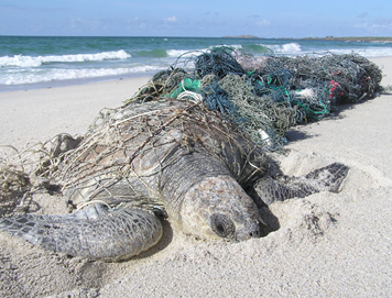
Figure 1. Dead turtle caught in a derelict ghost net. (Photo: Jane Dermer, Ghost Nets Australia)

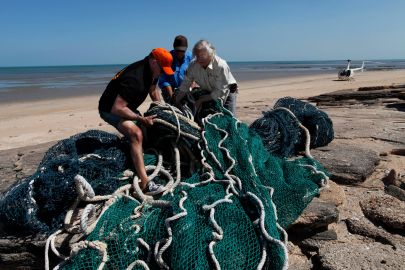
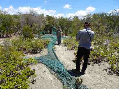
Introduction. The focus of our 2009 feature was to highlight the work of Indigenous rangers in addressing the local but widespread problem of abandoned, lost or derelict fishing gear (ALDFG) in Northern Australia, particularly ‘ghost nets’ that are carried on the currents and continue to fish long after they are no longer actively used (Figs 1-4). We also aimed to raise awareness of the efforts required to address this complex issue, whilst highlighting the work of Indigenous rangers working in the region.  The feature reported ghost net removal efforts taking place in Australia’s Gulf of Carpentaria – which, by 2009, involved the removal of 5532 nets by over 90 Indigenous rangers from more than 18 Indigenous communities.  This highlighted the transboundary nature of the ghost gear issue, and identified that most nets likely originated from beyond Australia’s waters.

Figure 2. Napranum ranger Philip Mango releasing juvenile turtle trapped in ghost net. (Photo: Ghost Nets Australial)

Further work. Since 2010, the understanding of and approaches to addressing the derelict fishing gear issue have increased substantially. This has been reflected both in domestic efforts within Australia, and more broadly in the international community.

Domestically, in the last decade, the ranger program across northern Australia has evolved and grown, enabling more Indigenous people to remain culturally connected to their land and sea country through meaningful employment.  Ranger activities generally involve a range of restoration activities including feral and weed management, in addition to (for  coastal groups) ghost net removal. Across northern Australia, Indigenous ranger groups continue to remove nets on their country, demonstrating the success of the initial program supported by the Australian government. To date, nearly 15,000 ghost nets (three times the number reported in 2010) have been removed from the region. The net removal program has extended beyond Ranger groups working in the Gulf of Carpentaria to include the Torres Strait, the western part of the Northern Territory Coast, and parts of the Kimberly coastline in Western Australia.

Globally, the world is focused on the United Nations Sustainability Development Goals (SDGs) which aims to provide a ‘shared blueprint for peace and prosperity for people and the planet, now and into the future’ (https://sustainabledevelopment.un.org/sdgs).

A key focus for the SDGs is to help preserve the world’s oceans, a topic which touches on food security, poverty and economic growth, among other goals. Ensuring fishing practices are aligned with these goals includes reducing gear losses into the marine and coastal environment. In recognition of the issue and to end ALDFG, there is now a multi-stakeholder alliance of fishing industry, private sector, multinational corporations, non-government organizations, academics and governments, the Global Ghost Gear Initiative (GGGI), which is focused on solving the problem of abandoned, lost and derelict fishing gear worldwide. Both CSIRO and GhostNets Australia were founding members of this alliance and have been instrumental in engagement and scientific endeavours which inform the GGGI.

Fig 3. An enormous effort is invested by Indigenous rangers in removing ghost nets from beaches along the northern Australian coastline (Photo: World Animal Protection/Dean Sewell)

Based on collaborative research between GhostNets Australia and CSIRO, it was determined that the primary source of derelict nets washing ashore along Australia’s northern coastline was the Arafura Sea. Engagement with fishers in the region through a series of workshops identified that major causes of gear loss included snagging of nets and over-capacity in the region. We also identified opportunities to help resolve ghost net issues in the region, though stakeholder engagement, points of intervention and livelihood tradeoffs. Much of this overcapacity and overcrowding has been attributed to illegal, unreported and unregulated (IUU) fishing. Subsequently, Indonesia went through a substantial change in practices with regards to allowing foreign vessels in their waters, effectively closed their borders to foreign fisheries operators. Anecdotally, information from multiple ranger groups in Northern Australia suggests that this highly publicized and significant change in practice has resulted in a substantial decrease in the number of ghost nets washing ashore along at least part of the northern Australian coastline.

Another outcome from the collaborative research effort was a new understanding based on deep citizen science engagement and modelling to identify potential high risk areas where ghost nets were likely to cause the most harm to turtles. In this work, we were able to suggest interdiction points for ghostnets, before they entered the Gulf of Carpentaria where they were likely to kill wildlife. We also identified the nets that were most harmful to wildlife and we estimated that nearly 15,000 marine turtles had likely been killed by derelict nets in the region.

There have also been some technological improvements in this area. These fall into both reporting and in tracking nets. Electronic data collection has improved the quality of data collection and can ensure errors are minimised. Development of the tool has also been designed such that those with reduced literacy are also able to collect valuable information, a feature that can be important in many communities. Using icons and photos to help identify nets improved data reliability.

Also within Australia, alternative livelihoods programs such as Ghost Net Gear evolved into the Ghost Net Art Project where the art works have excited the International art community.  This has resulted in purchases by many internationally renowned purveyors of artwork including the British Museum, the Australian National Museum and the Australian Maritime Museum. Works from Indigenous artists can also be seen at Australia’s Parliament House, and exhibitions have taken place in Monaco, Alaska, Singapore and France as well as in numerous national and regional galleries around Australia. A commemorative stamp was even made from the Ghost Nets artwork that lives in the Australian National Museum.

Figure 4. Large nets can become entangled in coastal vegetation. (Photo: World Animal Protection/Dean Sewell)

Future directions. While GhostNets Australia has not formally continued as a non-governmental organization, many of the components initiated through the program have continued and grown through time, as exemplified above. This early work also helped springboard CSIRO’s engagement in capacity building with the Indonesian government to tackle Illegal, Unreported and Unregulated (IUU) fishing. This had led to a strong research collaboration relationship between the two countries, with a shared goal of reducing IUU fishing, building capacity on marine resource management, and improved monitoring, control and surveillance efforts in Indonesia.

CSIRO is also involved in an aerial (re)survey of the coastline across Northern Australia. In affiliation with World Animal Protection and Norm Duke and Jock Mackenzie from James Cook University, we are looking at changes in the number of ghost nets along the shoreline (Figs 3 and 4). Stereo images were recorded along the entire coastline and we are comparing ghost nets observed across the region with two other aerial surveys that have taken place in the last decade. The team have just completed flights (September 2019), so we are looking forward to analysing the images and comparing ghost net numbers across the region.

ContactDenise.hardesty@csiro.au; CSIRO Oceans and Atmosphere, Hobart, Tasmania, Australia. rikigunn1@outlook.com; chris.wilcox@csiro.au

More than just a Long Paddock: Fostering native vegetation recovery in Riverina Travelling Stock Routes and Reserves – UPDATE of EMR feature

Ian Davidson

[Update of EMR feature – Davidson, Ian and Peter O’Shannassy (2017) More than just a Long Paddock: Fostering native vegetation recovery in Riverina Travelling Stock Routes and Reserves. Ecological Management & Restoration, 18:1, 4-14.  https://onlinelibrary.wiley.com/doi/10.1111/emr.12247]

Roger Harris with direct seeded shrubs –  Rand TSR. (Photo Ian Davidson)

Introduction.  As described in our 2017 EMR feature, the Enriching biodiversity in the NSW Riverina project was a five-year project funded by the Federal Government’s Carbon Farming initiative and managed by Murray Local Land Services (LLS). The project aimed to maintain the condition of the highest quality TSRs and improve the condition of 10% of all other TSRs, some of which had been receiving degrees of grazing management for many decades to optimize resilient native pastures (Refer to our earlier 2005, EMR feature). Given the NSW Riverina TSR network contains over 600 reserves, a sample was first selected for inspection to identify reserves with the potential for further active management. This led to the implementation of recommended land management and works on 109 reserves covering 13,558 ha and the subsequent monitoring of those reserves. Results indicated that, of these reserves, 70 had improved in vegetation condition by 2017. This project proved that large scale protection and improvement of TSR condition was possible using existing staff and provided valuable lessons that could be applied elsewhere across the state.

Table 1 Summary of key lessons learnt from the project and recommendations for effective TSR management

Human resources ·       Use existing knowledge where available

·       Maintain continuity of leadership

Assessment and

monitoring

·       Establish broadly applicable and consistent assessment and monitoring criteria

·       Use methods which are easily understood

·       Consider seasonal effects on the timing of surveys

·       Recommended actions should be appropriate for the site condition

Project Scale ·       Larger project areas and longer project timelines increase the rate of success

·       Regular monitoring avoids major problems

Revegetation ·       Seed banks are vital to achieving large scale revegetation

·       Multiple species should be used in direct seeding

·       Exotic grasses should be controlled prior to direct seeding

·       Native species can assist in spreading shrubs over time

Land Management ·       Controlling herbivores is critical during early growth stages

·       Grazing indicators/surrogates are useful

·       Stock type impacts grazing style

·       Cattle can graze areas with shrub seedling germination under certain conditions

·       Fencing and water points offer flexibility in managing stock for regeneration

·       Noisy Miners reduce small woodland bird numbers and they are difficult to control

Unplanned Impacts ·       Human intervention in unpredictable Natural events can lead to major changes in land management focus

Stuart Watson monitoring vegetation at Narrow Plains TSR. (Photo Ian Davidson)

Subsequent developments. Since the publication of our 2017 feature ‘More than just a Long Paddock: Fostering native vegetation recovery in Riverina Travelling Stock Routes and Reserves’ the following five key developments regarding nature conservation on TSRs in NSW have occurred.

  1. Developing and applying a simple field based consistent method for assessing and monitoring vegetation condition across the TSR network – A new rapid assessment and monitoring method was developed and trialed in this project for use by land managers with limited botanical and scientific skills and limited time. This field-based method known as Rapid Conservation Assessment Method (RAM) proved useful and has the potential for broader adoption across NSW. For detailed information refer to https://www.lls.nsw.gov.au/livestock/stock-routes/conservation-of-tsrs
  2. Categorizing the conservation status using an agreed method of TSRs across NSW – Using the RAM to complete assessments and collating all previously assessed TSR reports, LLS developed a consistent statewide map of the conservation status for the 534,000ha under their control (refer to https://www.lls.nsw.gov.au/livestock/stock-routes/conservation-of-tsr). This enabled LLS, the statewide land manager, to better understand the overall vegetation condition, extent and distribution of their TSR assets from a nature conservation perspective.
  3. Developing a Best environmental management practice (BeMP) Toolkit for TSRs to ensure good long-term conservation objectives – Key knowledge learnt from the Riverina project, LLS ranger’s knowledge and experience and existing literature influenced the development of the NSW Travelling Stock Reserves State Planning Framework 2016–21 (the Framework), which provides the framework for managing TSRs for conservation. A Best Environmental Management Practice (BeMP) toolkit was also prepared from this collation of knowledge to assist LLS deliver land management outcomes (including grazing, apiary, native seed collection, emergency response/refuge for livestock, threatened ecological communities and species, revegetation on TSRs, weed control, pest animal control, soil disturbance and drainage changes) consistent with the Framework. The BeMP is currently in draft form.
  4. Developing a statewide plan of management (PoM) for TSRs to ensure consistency across administrative boundaries – The NSW government is finalizing the details of a PoM which provides LLS staff, TSR stakeholders, investors, partners and customers with our shared vision and common mission. It sets out agreed strategies, approaches, principles and quality system to better manage the reserves. This PoM aims to improve social, economic, environmental and cultural outcomes while maintaining grazing as an important economic use and conservation tool. Importantly this plan establishes the need for shared responsibility and collaborative funding. For more information refer to https://www.lls.nsw.gov.au/__data/assets/pdf_file/0005/839930/NOV-TSR-PoM-MOedits-1.pdf
  5. Attracting significant investment to assist with protection and maintenance of TSR environmental values – LLS the managers of NSW TSRs receive no recurrent funding from government for the environmental management of the TSR estate and therefore have been dependent upon the proceeds from permits and leases e.g. grazing and annual grants e.g. weed and pest animal control to maintain the condition of TSRs. Now however, based on the PoM and guided by environmental management and works consistent with best environmental management practice, the LLS is negotiating with a government investor to fund agreed long term maintenance and enhancement of selected high and moderate conservation value TSRs.

Peter O’Shannassy with direct seeded shrubs on Snake Island TSR. (Photo Ian Davidson)

Lessons learned. Together, the five developments above show how the large-scale restoration project reported in 2017 has been further developed as a model for TSR protection and restoration across NSW, enabling buy-in by LLS to better manage these invaluable natural resource assets across NSW.

Acknowledgements. LLS staff Peter O’Shannassy steered most aspects of the project from its inception, whilst Stuart Watson and Roger Harris managed most of the on-ground management and works and lately Gary Rodda the Murray General Manager who has overseen the statewide development of the PoM. Lastly, I dedicate my TSR work to my great mate Rick Webster who was lost to us recently and with whom I shared a deep, long standing curiosity and love of these special areas.

Contact.  Ian Davidson (for technical matters) ian@regenerationsolutions.com.au  or  Peter O’Shannassy  (for land management and operational matters) peter.o’shannassy@lls.nsw.gov.au


Butterfly population persists 10 years after emergency habitat restoration and translocation – UPDATE to EMR feature

[Update to 2008 EMR feature  –  Raymond Mjadwesch and Simon Nally (2008) Emergency relocation of a Purple Copper Butterfly colony during roadworks: Successes and lessons learned. Ecological Management & Restoration,  9:2, 100-109.   https://doi.org/10.1111/j.1442-8903.2008.00400.x]

By Simon Nally and Raymond Mjadwesch

Fig 1.  The endangered Purple Copper Butterfly (Paralucia spinifera) (Photo Raymond Mjadwesch)

Key wordsParalucia spinifera, Purple Copper Butterfly, reintroduction, invertebrate, threatened species.

Introduction: As reported in the original EMR feature, the unintended destruction of the habitat of a population of the endangered Purple Copper Butterfly (Paralucia spinifera, Fig 1) north of Lithgow, Australia in 2004, precipitated a bold, innovative, and rapid emergency program of habitat restoration and butterfly larvae translocation.

A stand of the butterfly’s larval host plants, Blackthorn (Bursaria spinosa subsp. lasiophylla), had been largely destroyed to enable road construction (Fig 2a). The butterflies had commenced emerging from their nearly nine-month-long pupation in the attendant ant’s (Anonychomyrma itinerans) underground nests to find an absence of host plants.

Construction work ceased immediately, and supplementary Blackthorn plants were planted throughout the area of predicted butterfly emergence. The Blackthorn were planted in their pots, to allow for later removal and replanting in the area where the habitat was being restored.  The Blackthorn were sugar-baited to attract the attendant ant as the ant was assumed to affect the male butterfly’s selection of home ranges, and ultimately, egg-laying on these larval host plants. Concurrently with the provision of Blackthorn for egg-laying, an adjoining degraded area of potential habitat was treated for infestations of woody weeds and growth of emergent Eucalyptus trees that excluded Blackthorn or blocked sunlight, precluding its suitability for occupation by the species.  Once weeds were controlled, Blackthorn was established in this area using tube-stock planting.

Attendant ants were enticed to all the Blackthorn introduced to the site, male butterflies established territories and were successful at attracting females with whom to mate, and these females laid eggs on the Blackthorn. The project partners were relieved at these initial results! However, as much of the site was to be permanently destroyed due to road construction, this temporarily reprieved population had to be translocated.

Over 12 nights, 1,260 of the facultatively nocturnal larvae were collected (along with any associated attendant ants) as they emerged to feed on Blackthorn leaves and translocated to the newly created habitat established on an adjacent restoration area (Fig 2b). Each translocated larva was monitored until it was attended by ants (again attracted to the recipient habitat using a sugar bait). Further monitoring continued to confirm continued growth of larvae until pupation was assumed to occur.

The duration of the emergency habitat restoration and translocation activities from first discovery of the habitat destruction to the assumed pupation of the translocated larvae in the newly established habitat (Fig 3) was less than five months.

After the autumn and winter pupation period, the project partners were delighted to find butterflies emerging, mating, and laying eggs on the remaining restored habitat, one year after the initial habitat destruction was first detected. Monitoring of larval numbers during 2005-2008, which involved systematic nocturnal inspection of all Blackthorn plants at the site, indicated that the population was secure and had grown after an initial reduction in calculated numbers in the first year after translocation.

Figure 2a. 2004 – The site as found showing the extent of habitat destruction (when the butterfly and habitat loss was initially detected). (Photo Raymond Mjadwesch)

Figure 2b. 2005 – Larvae from yellow-delineated area were translocated (after temporary introduction) into the blue-delineated area and bushland further right. (Photo Raymond Mjadwesch)

Monitoring update: In 2013 and 2015 monitoring reverted to an area search method, counting flying butterflies – a technique routinely used to indicate butterfly distribution / areas of activity at each of the other known populations. In 2015, ten years after the emergency translocation and habitat restoration, 48 butterflies were observed in the restored habitat, the second highest number recorded for this site.

Note that the results of monitoring counts can vary with date of survey relative to the flying period, time of day, and weather conditions on the day, and represent an indicator of presence and activity rather than a measure of absolute abundance. During some years multiple monitoring events occurred; in 2013 and 2015 there was only a single monitoring count.

There have been no further nocturnal larvae counts since the culmination of the project.

A 2019 site assessment identified the need for further woody weed maintenance works (which has been ongoing in the interim, funded by the LLS) to avoid potential degradation of the habitat quality due to competition with and shading of the host plant, Blackthorn.  Longer term maintenance of this site may require active management to ensure persistence of Blackthorn either through burning or mechanical damage to Blackthorn to promote re-sprouting from the rootstock and juvenile leaf production. Juvenile leaves lack the hairy indumentum present on the lower surfaces of intermediate and adult Blackthorn leaves, and have been observed to be preferentially skeletonized by early-instar larvae.

The 2019 site inspection also revealed that powerline easement works had resulted in weedicide spraying of eucalypt (Eucalyptus ssp.) saplings throughout the restored habitat, with Blackthorn plants and other native plant species affected.

Figure 3a – the site in 2005, after restoration works were complete, showing the initial flush of pioneer species after soil disturbance and restoration. (Photo Raymond Mjadwesch)

Figure 3b – the site in 2019 showing the final shrubby understory of sedges and shrubs (including scattered Blackthorn) typical of the locally native open forest community. (Photo Raymond Mjadwesch)

Lessons learned and future directions: Several factors contributed to the success of the habitat restoration and translocation program, some of which were of notable serendipity. It was extremely fortunate that the species was detected within the affected area (after the initial survey of the site had failed to detect habitat for the species); that Blackthorn tube-stock (upon which the restoration relied) was available; that an area considered likely to support Purple Copper Butterfly suitable for rehabilitation lay adjacent to the affected area; and that the timing of the damage in the annual lifecycle of the species allowed the partners to work with the opportunity to establish larval food plants  when it was required.

However, we believe that it was human factors that fundamentally combined to create the environment for success:

  • the commitment of the NSW Roads and Maritime Services (then the RTA) to immediately and fully support restoration works to ameliorate the damage and maximize the chances of the population surviving in the long term, including changing the design of the works to reduce the extent of permanent damage, and the funding of the restoration, translocation, and monitoring activities.
  • the project partners, including the authors, the RTA, NSW National Parks and Wildlife Service, Australian Trust for Conservation Volunteers, and Lithgow LandCare unified in collaboration, ceasing other activities to direct all necessary effort to maximize chances of success.
  • the quick, resourceful and bold action to trial and implement innovative techniques that were risky and speculative, such as luring attendant ants to planted Blackthorn using sugar, trial translocating attendant ants, and translocating larvae.
  • that there had been sufficient field observations to  predict the likely behavior of butterflies and larvae and to predict the likely response of the species’ habitat to management intervention.

We encourage restoration practitioners to immerse themselves in the environments they intend to manipulate, and ponder on the behavior, function, and interactions between each element of the ecosystem before them. When choosing to act – to intervene – to manipulate, do so sensitively to what you both know and feel that you have learned in the field, and act decisively, quickly, and boldly. Most importantly, corral a team of partners who believe in the endeavor and who fully commit their support to each other for a common restoration objective.

Endnote: In September 2019, an unplanned fire burnt much of the site. Given the monitoring data available for this site, further monitoring to study the effect of fire on the species and its habitat is being considered.

 Stakeholders and Funding bodies:   NSW Roads and Traffic Authority (now NSW Roads and Maritime), NSW National Parks and Wildlife Service (now NSW Office of Environment and Heritage), Australian Trust for Conservation Volunteers, Lithgow LandCare, Australian Government Department of Environment and Energy

Contact information: Simon Nally, 8 Gurney Place PAGE ACT, Australia, Tel: +61 407870234, Email: suseandsimon@bigpond.com. Ray Mjadwesch, Mjadwesch Environmental Service and Support, 26 Keppel Street, Bathurst, NSW 2795 Australia, Tel: +61 423949789, Email:  ray@mjadweschenvironmental.com.au

Is revegetation in the Sheep Pen Creek area, Victoria, improving Grey-crowned Babbler habitat? – UPDATE of EMR feature

Doug Robinson

[Update of EMR feature Robinson, Doug (2006) Is revegetation in the Sheep Pen Creek area, Victoria, improving Grey‐crowned Babbler habitat?  Ecological Management & Restoration, 7:2, 93-104.  https://doi.org/10.1111/j.1442-8903.2006.00263.x]

Key words: (<5 words): Monitoring, restoration, population ecology, woodland conservation

Figure 1. Location of babbler project works and other landcare works implemented since 1996 in the Sheep Pen Creek Land Management Group area and the two sub-districts used for the babbler study. (Source TFNVic)

Introduction: The Grey-crowned Babbler (Pomatostomus temporalis) (babbler) is a threatened woodland bird (classified as Endangered in the state of Victoria) that has declined substantially in overall distribution and abundance across much of its former range in southeastern Australia since European settlement.  Sheep Pen Creek Land Management Group area, in northern Victoria (Fig 1), was fortuitously the location of the largest known remaining babbler population in Victoria in the early 1990s (when this project began); and the focus of extensive land restoration programs from the 1980s onwards to help mitigate the impacts of erosion and dryland salinity, as well as biodiversity decline.  The original study, published in 2006, investigated the overall changes in tree cover across the district between 1971 and 1996 as a result of different land-management actions and responses of local babbler populations to those habitat changes.  The key finding was that in the Koonda sub-district which had a 5% overall increase in tree cover to 14% from 1971 to 2001, showed an increase in babbler numbers by about 30% (Table 1).   In the Tamleugh sub-district, tree cover increased by 1.3% to a total of 9%, with no change in babbler numbers.  The findings also showed that new babbler groups were preferentially colonizing new patches of vegetation established that suited their habitat needs.  Building on this research, the study concluded that future conservation programs needed to scale-up the extent of habitat restoration, target areas which were suitable for babbler colonization, and tailor incentive programs to assist with conservation of particular species.

Table 1. Changes in Grey-crowned Babbler numbers over time

Year Koonda Tamleugh
number of groups number of birds number of groups number of birds
1992 20 78 11 39
1993 20 89 10 34
1996 24 96 9 35
1997 24 102 8 30
1998 25 99 10 40
2000 26 97 10 43
2005 23 99 8 34

Further revegetation works undertaken. Since the initial study’s assessment of vegetation changes between 1971 and 1996, an additional 133 ha of vegetation has been restored or established as babbler habitat in Koonda district and 37 ha in the Tamleugh district (Figs 2 and 3, Table 2).  Extensive natural regeneration, supplemented by broadscale revegetation, has also occurred over more than 350 ha on five private conservation properties in the Koonda district,, contributing to substantial landscape change.  The wider landscape has also been identified as a statewide priority for nature conservation on private land, leading to increased conservation investment in permanent protection there by Victoria’s lead covenanting body – Trust for Nature.

Monitoring of outcomes: The monitoring that was carried out prior to the 2006 publication has not continued, leaving a knowledge gap as to how the population has fared in the context of the Millenium Drought and ongoing climate-change impacts. However, based on the original research’s initial findings, we conducted an experimental study with University of Melbourne to evaluate the effectiveness of habitat restoration in maintaining babbler survival. The study, published by Vesk and colleagues in 2015, compared the persistence and group size of babbler groups present in 1995 and subsequently in 2008 at a randomly selected set of stratified sites which had either had habitat works or none.  This study was conducted across a larger landscape of about 200,000 hectares which included Sheep Pen Creek Land Management Group area.  The study found that babbler group size decreased by about 15% over the 13 years at sites without restoration works.   At sites with restoration, average group size increased by about 22%, thereby effectively compensating for the overall reduction in numbers reported over that time.This increase also influenced subsequent demographic performance, with groups at restoration sites having higher breeding success and more fledglings than groups at control sites.

Another useful finding from this experimental study was the confirmation of the importance of particular habitat and landscape variables on babbler persistence.  In particular, abundance of large trees was a positive predictor of occupancy over time; and distance from the next nearest group was a negative predictor.

Figure 2. Changes in tree cover in the Koonda sub-district between 1971 (top),  and 2018 (bottom). (Source TFNVic).. (Source TFNVic)

Figure 3. Changes in tree cover in the Tamleugh sub-district between 1971 (top) and 2018 (bottom). (Source TFNVic)

Table 2.  Summary of additional habitat established or restored as part of the Sheep Pen Creek Grey-crowned Babbler project from 1996-2018, following the initial study period from 1971-1996.

District Number of sites Area (ha)
Koonda 62 133
Tamleugh 28   37
Other parts of landcare group and local babbler population area 29 103
Totals 119 273

Expansion of lessons to other districts: Building on the fundamental research conducted in Sheep Pen Creek Land Management Group area, similar habitat, landscape and babbler population assessments were subsequently undertaken in northwest Victoria near Kerang for the babbler populations found there.  Key results from these studies relevant to the initial Sheep Pen study were that the number of babbler groups in each sampled district was positively related to the proportion of woodland cover, especially the proportion of Black Box (Eucalyptus largiflorens) woodland habitat – the babblers’ preferred habitat in this region.  Conversely, the number of babbler groups was negatively associated with the proportion of land under intensive agriculture.  At the site scale, key positive predictors of babbler presence in Black Box habitat again included the abundance of large trees (> 60 cm dbh)

Lessons learned and future directions: The most valuable lesson learned since the initial paper was published was the power of the structured research project described above to evaluate the effectiveness of the babbler conservation program and inform future design and planning. The study further demonstrated the importance of taking a demographic approach to the species’ conservation needs, understanding what is happening across the whole population over time  and how habitat interventions can assist.  These lessons have since been applied usefully to other babbler projects  and more broadly to conservation of woodland birds.

The initial paper noted the importance of achieving landscape-scale change in vegetation extent, particularly in more fertile habitats. This has occurred to some extent within the Koonda district through a range of incentive programs, tender programs, covenanting programs and land purchase, but continues to achieve most gains on more infertile land. On fertile land, by contrast, there has been rapid land-use change to cropping over the past fifteen years, leading to reduced likelihood of those properties providing suitable habitat for babblers, as found in the study conducted in northwest Victoria.

The initial paper also suggested the benefit of developing tailored incentive programs for babblers and other threatened species with particular requirements to maximize potential conservation gains  and we suggest, based on Australian and overseas experiences,  that more specific incentive programs or more detailed criteria could assist.

Another important lesson learned was the difficulty in maintaining community-driven citizen-science monitoring, even with the best will in the world, without some over-arching organizational support and oversight.  We know that community monitoring for biodiversity conservation needs scientific input at the design and analysis stages; hence additional resources may also be required in terms of equipment or guidelines to help groups monitor effectively.  Modest government investments to conservation organisations with established biodiversity monitoring programs could usefully help address this issue.

Finally, the learnings from the Sheep Pen Creek Land Management babbler conservation project over nearly thirty years are that the landscape changes and that these changes are not always positive.  Land-use change is placing more pressure on  potential babbler habitat; and the eucalypt regrowth which was established and provided new nesting resources for a few years is now too tall to provide nesting habitat, but too dense and immature to provide suitable foraging habitat for another one hundred years.  Climate change is rapidly imposing constraints on the availability of food resources and breeding opportunities, exacerbated by increased competition for the same limited resources by exotic and native species.  For the Grey-crowned Babbler, the solution to all of these factors depends on ongoing commitment to the establishment or maintenance of their essential habitat needs and life-history requirements so that their life-cycle is provisioned for from generation to generation.

Stakeholders and Funding bodies:   Most of the targeted habitat works achieved for babblers in this landscape has occurred through funding support from the Australian government through its Natural Heritage Trust and Caring for our Country programs.  Broader habitat protection and restoration has occurred primarily with funding support to landholders from the Goulburn Broken Catchment Management Authority (GBCMA).  The Norman Wettenhall Foundation, along with GBCMA, was instrumental in enabling the research by University of Melbourne, which was also aided by the extensive voluntary support of Friends of the Grey-crowned Babbler.  Not least, local landholders continued to support the project and continue to protect or restore parts of their properties to assist with babbler conservation.

Contact information: [Doug Robinson, Trust for Nature, 5/379 Collins Street Melbourne, Victoria 3000, Australia.  dougr@tfn.org.au, (03) 86315800 or 0408512441; and  School of Life Sciences, La Trobe University, Bundoora, Victoria, Australia.


Restoration of Wollongong’s Tom Thumb Lagoon 25 Years On: UPDATE of EMR feature.

 Nicholas Gill

[Update of EMR feature: Gill, Nicholas (2005) Slag, steel and swamp: Perceptions of restoration of an urban coastal saltmarsh. Ecological Management & Restoration, 6:2, 85-93 https://onlinelibrary.wiley.com/doi/10.1111/j.1442-8903.2005.00224.x]

Keywords. coastal wetlands, urban green space, pollution, mangroves, volunteers.

Figure 1. Tom Thumb Lagoon and Greenhouse Park (a) 2008 and (b) 2017. (Source Google Earth)

Introduction. The 2005 feature was drawn from restoration work my students and I became involved in during the early 2000s at Tom Thumb Lagoon (TTL) – an estuarine wetland close to Wollongong’s CBD and adjacent to the Port Kembla industrial area and harbour. By that point Wollongong City Council (WCC), the Bushcare group Friends of Tom Thumb Lagoon (FTTL), industry, Conservation Volunteers Australia (CVA), and many volunteers had been variously working on the site since the early 1990s. After decades of impacts from industrial development, waste disposal, and neglect, this significant restoration effort encompassed removing landfill, reshaping the wetland with channels and shallow benches, revegetation, weeding, and the construction of access and viewing points. By the time we became involved and I wrote the 2005 paper, TTL and the adjacent Greenhouse Park (GHP; Fig 1), were substantially revegetated, aesthetically improved, and the saltmarsh wetlands were seen as ecologically valuable. Participants and stakeholders in the restoration project perceived that substantial progress and improvement had been made. They also perceived, however, that the project suffered from some issues common to such endeavours such as a lack strategic planning and monitoring of ecological outcomes.

Since this time, restoration and other work has continued at TTL and at GHP. The story of what has happened, however, is one of the dynamic and contextual nature of sites such as this. This is true in a biophysical sense of ongoing vegetation change, particularly the spread of Grey Mangrove (Avicenna marina), a native plant previously not occurring on the site but planted for perceived environmental benefits either in the 1990s, or around 2000. This spread (into what was previously saltmarsh and mudflats) arises from past decisions and, while providing benefits, is now potentially causing new problems as well as continuing debates about choices in restoration.  The social context has also been dynamic and influential, as priorities have shifted, as the funding environment has altered, and as the people and groups involved have changed. Finally, Tom Thumb Lagoon remains affected by the legacy of the industrial history of its location. Past waste disposal practices in the absence of regulation have led to pollution problems that have become of greater concern since the early 2000s.

Activities at Tom Thumb Lagoon and Greenhouse Park Today. The wetland area itself is adjacent to a capped waste disposal site that operated from the 1940s until the mid-1970s. This area is known now as Greenhouse Park and is being managed and developed as urban green space with more focus on fostering urban sustainability practices; any restoration work is nested within these foci. TTL and GHP were always associated through overlap between FTTL and GHP staff, and GHP facilities were a base for TTL activities. Today, however, personnel have changed, FTTL no longer exists and its key members are no longer associated with TTL, and TTL/GHP are managed as one site to a greater extent. The result of these factors, and of the achievements already made at TTL, have been a shift towards an emphasis on activities at GHP and a change in TTL activities from active restoration to maintenance. It is now GHP volunteers and associated WCC staff who undertake and oversee work at TTL. At GHP WCC has expended considerable resources in tree planting and expanding a permaculture garden. There is a shelter, outdoor kitchen, and pizza oven for volunteers, WCC and Wollongong firms compost green and food waste, and there are hopes for public, tourism, and event use. Around ten volunteers work at the site weekly. For the GHP staff and volunteers, activities at TTL itself today are largely limited to weeding, picking up litter, and feral animal control. Weeds and litter remain problems, partly due to TTL’s location at the bottom of an urban catchment. In addition, since 2005, frog ponds were installed at the eastern end of TTL for the endangered Green and Golden Bell frog (Litoria aurea), however, it is not clear if the ponds are effective. The non-native Giant Reed (Arundo donax) also remains well established at this end of TTL despite control attempts.

Shifts in support have meant that CVA bowed out of work at TTL/GHP in 2012. Previously their involvement had been via a wetlands program that relied on support from both industry (including Bluescope and NSW Ports, both operating adjacent to TTL) and government programs. Until 2012, in conjunction with WCC, CVA were revegetating the southern slopes of GHP (marked A in Fig. 1) and were removing weeds and litter from the saltmarsh. However, the funding that CVA relied on declined such that CVA was unable to continue at TTL/GHP.

Figure 2.  Eastern end of TTL looking south (a) 2002 and (b) 2019 (Photos Nick Gill)

The Mangroves are Coming. Apart from further revegetation at GHP, the most significant vegetation change at TTL has been the spread of Grey Mangrove. While approval to thin this species has been obtained in the past and some thinning did occur, it has not mitigated their current spread and density. Grey Mangrove spread is clearly seen for the period from 2002 to 2019 in Fig 2 which shows the eastern end of TTL and the southern end of the channel known as Gurungaty Waterway. Aerial photos further reveal changes from 2008-2017 where the largely east-west spread of mangroves along channels in TTL can be seen (marked B in Fig 1). Significant spread can also be seen north-south spread along Gurungaty Waterway over this period (marked C in Fig 1). As the 2005 paper records, not long after Grey Mangrove was planted in the late 20th or early 21st Century, its expansion was  soon causing concern for its consequences for the site’s mudflats, saltmarsh and tidal habitats although it appears to have largely remained confined to the channels and has no doubt generated some environmental benefits. In terms of its consequences on bird habitat, the long observations of local birdwatchers suggest that the expansion of Grey Mangrove has reduced the incidence of waders and shorebirds, particularly Black Winged Stilts (Himantopus himantopus) and also waterfowl and herons. Nonetheless, observers report that Grey  Mangrove colonisation is providing habitat for other birds, such as the Sacred Kingfisher (Todiramphus sanctus), the Nankeen Night-Heron (Nycticorax caledonicus), and the Striated Heron (Butorides striata). Elsewhere across more upland areas of TTL and GHP, the expansion of tree planting across GHP and TTL has seen a shift to birds favouring woodland habitats.

The expansion of Grey Mangrove is also implicated in flood risk, especially for the catchment of Gurungaty Waterway. A 2019 review of the Wollongong City Flood Study, suggests that low elevations and channel infrastructure, combined with sedimentation and flow limitations associated with the now dense mangroves (Fig. 3), have increased the likelihood of flooding in the urban catchment.

Figure 3.  Southern Gurangaty Waterway in (a) 2002 and (b) 2019. Note the steel footbridge on left of each photo. (Photos Nick Gill)

Industrial Legacies. The 2005 paper notes that saltmarsh restoration was an important part of the TTL work and that stakeholders saw the saltmarsh as a significant ecological element of TTL. Since 2004 coastal saltmarsh has been listed as an Endangered Ecological Community in NSW. From 2006, saltmarsh degradation prompted WCC to monitor the saltmarsh and analyse groundwater and soils.  This showed that the degradation was likely associated with ammonia leaching from the tip and causing nitrate pollution, and also with a hydrophilic layer of iron hydroxide in the soil causing waterlogging and contaminant absorption. The possible origins of this layer include past waste disposal practices from metal manufacturing.

These, however, are not the only legacies of past unregulated waste disposal and industrial activity. TTL is now a declared site of ‘significantly contaminated land’ by the NSW EPA. The 2018 declaration notes that site is contaminated by ‘polycyclic aromatic hydrocarbons (PAHs), petroleum hydrocarbons and other mixed contaminants from multiple sources including coal tar and lubricant oils’. At TTL elements of these can be visible as a film on the water surface and are among the substances leaching from GHP. Such substances are carcinogenic and exposure can cause a range of health problems. The presence of these materials in the groundwater has been known since the 1990s but from 2013 WCC began to monitor and map these materials. Monitoring points were installed along the wetlands at base of the old tip. Various remediation options for these contaminants, as well as for the nitrates and iron hydroxide layer, were proposed but action was not taken at this time for various reasons including disruption to the wetland, costs, and uncertainties regarding pollutant interception. As of 2019, the site is subject to a ‘Voluntary Management Proposal’ by WCC which includes the preparation of a remediation action plan by late 2019.

Future Directions. The last fifteen years have seen some aspects of restoration, such as tree planting, proceed and expand. By some measures this is continued progress of the original project. TTL/GHP is now a well-established urban green space with environmental and amenity value. However, concerns from the early 2000s about volunteer succession, the absence of a catchment approach to management, and the need to think more strategically about ecological trade-offs between management options have been realised to some extent. The spread of Grey Mangrove is the clearest example of this. In part, some of this is perhaps inevitable for a site with the history and setting of TTL/GHP; the management context has changed, participants and stakeholders have changed, and difficult legacy issues have assumed greater prominence and cost. Nonetheless, the challenge to manage the site with a clear strategy and goals remains.

Acknowledgements: For assistance with this update, I am indebted to several past and present WCC staff, particularly Mike McKeon. I was also helped by Adam Woods, formerly of CVA, and birdwatchers Penny Potter, Terrill Nordstrom, and David Winterbottom.

Contact. Nicholas Gill, School of Geography and Sustainable Communities Faculty of Social Sciences, University of Wollongong NSW 2522 Australia, Email: ngill@uow.edu.au

The biodiversity benefits of Greening Australia’s Saltshaker Project, Boorowa, NSW – UPDATE of EMR feature

David Freudenberger, Graham Fifield, Nicki Taws, Angela Calliess and Lori Gould

[Update of EMR feature – Freudenberger, David, Judith Harvey and Alex Drew (2004) Predicting the biodiversity benefits of the Saltshaker Project, Boorowa, NSW. Ecological Management & Restoration, 5:1, 5-14. https://doi.org/10.1111/j.1442-8903.2004.00176.x]

Key words: woodland restoration, monitoring, farmland rehabilitation, community engagement

Figure 1. Boorowa River Recovery project sites, south eastern NSW.

Introduction

The Boorowa catchment in central NSW, like most of the wheat-sheep belt of eastern Australia, has been extensively cleared for agriculture.  Remnant woodland cover is less than 10% and highly fragmented into small patches, often less than 20 ha. As described in the 2004 article, there has been a documented decline in biodiversity across this region linked to declines in landscape function including dryland salinity and eucalypt dieback. In response to these declines, farmers in this catchment have been involved in land rehabilitation projects for over 25 years.  Many of these projects have been facilitated by Greening Australia, a national non-governmental organisation focused on protecting and restoring native vegetation.  Pioneering projects in the 1990s were often small in scale and lacked landscape scale targets.  To address this, Greening Australia collaborated with CSIRO to develop guidelines for catchment scale “enhancement activities” for the $1.8 Million “Saltshaker Project” that carried out ground works as described in Box 1 of the 2004 article (reproduced below). The project was based on a $845,000 grant from the Australian Government’s Natural Heritage Trust program and $1 Million in in-kind support from farmers, the Boorowa Shire, Boorowa Landcare and Greening Australia. This project ran for just two years (2000-2002), but it was hoped that the project would provide strategic guidance for decades to come.  This appears to be the case.

 Box 1. Priority ‘enhancement activities
1. Protect existing remnant vegetation by fencing out domestic livestock with a priority to protect 10 ha or larger remnants in the best condition (complex understorey).
2. Establish native understorey plants in those protected remnants requiring enhancement of habitat complexity.
3. Enlarge existing remnants to at least 10 ha.
4. Create linkages between fenced remnants and other protected remnants. Linkages should be at least 25 m wide, or 10 ha stepping-stones, particularly in those areas more than 1.5 km from other patches 10 ha in size.
5. Fencing and revegetation of at least 50 m wide along creeks and flow lines.
6. In recharge areas, revegetate in 2-ha blocks, or greater than eight row strips to intercept deep soil water moving down-slope.
7. Revegetate areas mapped as having a high risk of dryland salinity.
8. Block plantings in discharge areas with links to other saline reclamation works.

(Box reproduced with permission from the original feature]

During the Saltshaker project, bird surveys were conducted within 54 discrete patches of remnant woodland.  Bird species were identified that were particularly sensitive to loss of habitat area, simplification of habitat structure, and increase in habitat isolation. The Eastern Yellow Robin was the focal species for this catchment. It generally occurred in woodland patches larger than 10 ha that were no more than 1.5 km from other patches at least 10 ha in size, and had at least a moderate structural complexity made up of a healthy overstorey of eucalypts with an understorey of regenerating trees, shrubs, tussock grasses and fallen timber. The Saltshaker project predicted that many other woodland birds would co-occur if the habitat requirements of the Eastern Yellow Robin were met by patch and landscape scale enhancement activities.

Further works. The Saltshaker project was followed by many others since 2002. The largest project was “Boorowa River Recovery” that began in 2005 as a partnership managed by Greening Australia with the Lachlan Catchment Management Authority and the Boorowa Landcare Group.  Through a total investment of almost $2.2 million (in-kind included), this project rehabilitated or protected 640 ha of riparian area along 80 km of river including a continuous 29 km stretch of the Boorowa River above the town water supply dam (Figs 1 and 2). It involved more than 60 land managers who implemented on-ground works described in individual ten year management contracts. On-farm project size averaged 11.6 ha.

Other projects funded by a diversity of sources, particularly the Australian Government, have protected an additional 88 ha of woodland remnant, enhanced 353 ha of remnants, and revegetated 425 ha of native vegetation within the catchment.  Projects included Whole of Paddock Rehabilitation (WOPR).  All project activities linked to funding have been recorded in a detailed project management database held by Greening Australia. These additional projects were consistent with the enhancement activities recommended by the Saltshaker Project and described in the EMR feature.

Figure 2 (a) Before and (b) after willow removal in the Boorowa River Catchment. After willow removal, all sites were planted to a diversity of trees and shrubs.

Outcomes. There has been no comprehensive follow-up to the 2001 bird surveys across the Boorowa Catchment.  However since then, there is now a large and comprehensive scientific literature demonstrating dramatic increases in woodland birds in the revegetation areas in this region of southeastern NSW (reviewed in 2018). Most all the conservation and restoration activities in this catchment have likely led to an increase in woodland birds over the past 20 years.

Of all the Boorowa projects, the Boorowa River Recovery projects had sufficient funding for monitoring outcomes six years after project activities commenced. A sub-sample of 20 sites out of a pool of 47 were monitored for improvements in vegetation cover and density, macroinvertebrate abundance and stream bank stability. Planted shrub cover generally doubled at all sites as expected. Macroinvertebrate scores did not differ between treated and control sites, though activities did appear to improve stream bank stability (an indirect measure of reduced erosion).  Subsequent monitoring 12 years on showed further improvements in ecosystem function.

Since the Saltshaker Project finished, there has been no systematic monitoring of the hundreds of woodland remnants protected and enhanced by this project and subsequent ones.  However, landholders and staff anecdotally report indicative improvements in vegetation cover and wildlife habitat on the sites, and we can infer from a 2008 study that included woodland sites in the Boorowa Catchment, that significant ecological improvements are likely from fencing out livestock from woodland patches. This study found improvements included greater native floristic richness, native groundcover and overstorey regeneration within fenced sites compared to unfenced sites. Similarly, a 2009 study found that woodland sites in south eastern Australia, with livestock grazing removed, had a greater abundance of beetles and the opportunist ant functional group, a faster rate of litter decomposition, greater native plant richness, greater length of logs, and a better vegetation condition score.

Lessons learned. Long-term action with short-term funding. Natural resource management projects have been ongoing in the Boorowa catchment for over 25 years. But no single project has been funded for more than five years. This is the reality of natural resource management (NRM) in much of Australia.  Government NRM programs come and go with election cycles, but fortunately the commitment of landholders and local organisations persists.

Partnership model. All the projects before and after the Saltshaker Project have involved landholders working collaboratively with local agencies administering the diversity of funding. Most projects had a steering committee that proved a good way for stakeholders to have input through all stages of project, which was particularly important during project planning. Idealism needed to be balanced with practicality so bureaucracy was minimised while maintaining accountability. Good communication that recognised that no single view was more valuable than another was important, although full consensus was not always possible. Trust was enabled when processes were developed collectively. Skilled coordinators needed a clear understanding of their roles and care taken to not get involved in local politics.

Assessing outcomes. Developing a highly predictive understanding of ecological outcomes from NRM activities in catchments like Boorowa is a scientifically complex, expensive and long-term process. The confidence we can now claim for an increase in abundance and diversity of woodland birds in the Boorowa catchment stems from two types of monitoring. First is project monitoring of outputs like the 425 ha of revegetation known to have been established in the catchment. We know this from Greening Australia’s project management database (unfortunately there is no national database for this kind of outputs),  although satellite imagery should be able to pick up this output once plantings have a dense enough canopy. It is essential to know when and where project outputs like revegetation have occurred in order to then design scientifically rigorous studies to research ecological outcomes like increases in flora and fauna diversity and abundance. We have confidence that wildlife is colonising revegetation because research groups have conducted sophisticated statistical analyses of wildlife data from woodland revegetation in nearly 200 sites across south eastern Australia for over 15 years (summarised in a 2018 study).

Gaps in understanding. We know a lot about the ecological and social outcomes of NRM activities, but much less about improving the cost effectiveness of outputs such as revegetation and understory enhancements(see 2016 review). There are no recent published benchmarks on how much revegetation should cost in the face of variable climatic conditions, soil types and terrain.  More revegetation case studies need to be documented, but they need to include an accounting of costs.  The Australian restoration challenge is vast, funding always limited, so practical research and transparent accounting is sorely needed to reduce the cost of ecologically effective restoration.

Continuous re-learning. The many and diverse projects in the Boorowa Catchment are typical of NRM activities in Australian woodlands over the past 25 years. Each project has involved different agencies, many no longer exist or have changed their names (e.g. Catchment Management Authorities have morphed into Local Land Services in NSW). Each agency, including NGOs like Greening Australia, have a natural turn-over of staff. For example, only one staff member of Greening Australia involved in Saltshaker remains with the organisation.  Landholders tend to remain longer, but they too retire, sell out, and move on. Like education, every new staff member and every new landholder needs to learn the complex processes of successful catchment repair. This learning needs to be hands-on, hence funding for NRM activities and extension is needed in perpetuity (just like education). But experiential learning needs to be complemented with a diversity of learning resources such as the EMR journal, easily assessable reports (too many have disappeared from Government websites) and new media such as YouTube videos. Most importantly, communities of practice need to be perennially nurtured by a diversity of practitioners, experienced and less so.  There is much still to be learned and shared.

Stakeholders and Funding bodies:   The primary funding bodies for projects in the Boorowa catchment were the Australian Government, TransGrid, Alcoa Australia, the NSW Environmental Trust, and the former Lachlan Catchment Management Authority. These external funds were complemented by a diversity of in-kind support provided by farmers, Boorowa Shire Council, and other community members of the catchment.

Contact details. David Freudenberger, Fenner School of Environment and Society (Australian National University, Canberra, 0200, Australia, Email: david.freudenberger@anu.edu.au). GF, NT and AC can be contacted at Greening Australia, Kubura Pl, Aranda ACT 2614, Australia; and LG at GrassRoots Environmental, Canberra (http://www.grassrootsenviro.com/)


Ecological Restoration of Donaghys Corridor, Gadgarra, north Queensland – UPDATE of EMR feature

Nigel Tucker

[Update of EMR feature – Tucker, Nigel I. J. and Tania Simmons (209) Restoring a rainforest habitat linkage in north Queensland: Donaghy’s Corridor, Ecological Management & Restoration, 10:2, 98-112, https://onlinelibrary.wiley.com/doi/10.1111/j.1442-8903.2009.00471.x]

Keywords: Rainforest, corridor, regeneration, disturbance effects

Introduction. Complex notophyll vine forests of the Atherton Tablelands, particularly from basalt derived soils, have been significantly fragmented and degraded by human settlement over a 100yr period. Fragment isolation results in edge effects, exotic species colonisation, loss of genetic variability and species decline. During high rainfall events, eroding streambanks on farms mobilise sediments to the receiving environment of the Great Barrier Reef. Re-connecting isolated fragments to larger forest blocks through restored riparian corridors aims to reverse these effects through adaptive management. The restoration of Donaghys Corridor is an example of adaptive management, and its establishment was a key factor in the adoption of other local corridor projects.

As reported in the 2009 features, around 20,000 plants of selected local species were established in four yearly plantings (1995/96/97/98) along Toohey Creek, creating a continuous habitat corridor between the isolated Lake Barrine fragment (500ha) and the adjacent Gadgarra section of Wooroonooran N.P (80,000ha), both being part of the Wet Tropics World Heritage Area. The corridor is 1,200m in length and 100m wide, with three rows of Hoop Pine (Araucaria cunninghamiana) planted either side of the fenced corridor, which was established on lands largely owned by the Donaghy family. On completion, the corridor was secured through the Queensland Government’s declaration of Donaghys Corridor Nature Refuge, the State’s first Nature Refuge proclaimed over an ecologically restored site.

Ongoing recovery. In 2000, a vegetation survey of 3m x 5m plots in 12 permanent transects throughout the corridor showed regeneration had occurred upon canopy closure (Tucker and Simmons 2009).  Between 1995 and 1998, 119 native species had regenerated within the transects, mainly through vertebrate-mediated dispersal. The most recent (ongoing) survey, ca.20yrs after planting, indicates that regeneration has continued, and the majority of regenerating species are again vertebrate dispersed. There has also been a measurable increase in vegetation structural complexity, and a variety of life forms are present including ferns, orchids, vines, scramblers and canopy trees.

Restored vegetation in 2000 was characterised by vegetation of even age and size classes and only a developing canopy was present (no sub-canopy). Recruitment was limited to the ground storey. Over 20yrs, total numbers of recruiting species have increased, along with canopy height, and the sub-canopy is now a distinguishable and measurable feature. To illustrate this change, species diversity and structure in two typical transects from the oldest (1995) and youngest (1998) plantings are shown in the table below. Figures are from the most recent survey (2019) and the bracketed numbers indicate comparative values in 2000.

Canopy

height

Sub-canopy

Height

Number of species Average number of species/plot Average number of species/plot – sub-canopy Average number of species/plot – ground storey
1995 19.9 (5) 7.5 (0) 84 (53) 22.6 (12.5) 8.3 13.8
1998 14.4 (2.5) 7.3 (0) 63 (15) 14.2 (1.6) 2.2 15.8

There has also been a significant difference in the distribution of regenerating vegetation. In 2000, regeneration was negatively correlated with edge, being concentrated in the central portion of each transect. Greater structural complexity and increased shading have significantly reduced the edge effect and regeneration is now distributed equally across the entire width of the corridor. This edge-effect reduction may partially result from the three Hoop Pine rows, now ca.15m tall, planted on each side of the corridor.

Figure 1.  Part of the 18m x 250m fence crossing Donaghys Corridor

Natural and man-made disturbance. Since establishment there has been both natural and anthropogenic disturbance. Occasional incursions by cattle have occurred, entering via fences sometimes damaged by branches falling from maturing corridor vegetation. In small areas incursions have visibly damaged regeneration but surveys show this has not significantly affected regeneration. Feral pig disturbance has also occurred but does not appear to have affected regeneration.

In 2006, corridor vegetation was damaged by severe tropical Cyclone Larry. Most stems lost crowns and some waters’ edge stems were permanently bent by floodwaters, but vegetation recovery was rapid and no weed invasion occurred. This infers a measure of resilience by restored vegetation to disturbance, and the distribution of regeneration described above supports this inference.

Anthropogenic disturbance has been more interventionist and not aligned to the original concept adopted by government, landholders, scientists and the community when the project commenced in 1995.  In 2017, the corridor’s upstream neighbour, with support from the DES but without consultation with the Donaghy family or other affected landholders, erected a chain mesh fence 250m long and 1.8m high across the western end of the corridor (see Figure 1). This is part of a larger fence which completely encloses mature forest at the western end of the corridor, including corrugated iron placed across the bed of Toohey Creek. Enquiries revealed the fence is part of an enclosure for a Cassowary (Casuarius casuarius johnsonii) rehabilitation facility, operated by Rainforest Reserves Australia (RRA) under a commercial arrangement with the Queensland Government.

Enhancing landscape permeability was the key reason for undertaking the Donaghys Corridor project, and the endangered Cassowary was a key target species; 53 Cassowary food plants were included in the original planting matrix of 100 species to encourage corridor utilisation. The Queensland Government notes that corridors are a key strategy in Cassowary conservation. In addition to blocking the movement of terrestrial vertebrates such as Cassowaries, Pademelon (Thylogale stigmatica) and Musky Rat Kangaroo (Hypsiprymnodon moschatus), construction of the enclosure has inadvertently fenced in a number of animals whose territories included part of the enclosure.

DES has advised that the fence is temporary and will be removed when restoration plantings on RRA lands are ‘sufficiently well-developed’ to support Cassowaries being rehabilitated.  It is unknown, however, when or through what processes this removal will occur. Resolution of the issue is anticipated.  However, such actions highlight the pitfalls associated with single-species conservation, and potential conflicts that might arise when responsibility for management of endangered species moves from the State to the non-scientific, commercially-focused private sector. Whilst iconic wildlife e.g., the Cassowary, can be effective in harnessing community and landholder participation in restoration, here it is clear that decision making and communication has been far from optimal, which may well lead to landholder and community disillusionment. In this case, the fence has also disrupted ongoing monitoring and evaluation. Planned re-survey of terrestrial vertebrate colonisation and movement has now been cancelled, given the unknown effect of the fence on wildlife passage and the behaviour of animals inadvertently trapped within the enclosure.

Lessons learned.  The project shows that sustained regeneration of native species can be achieved in restored tropical vegetation, along with increased structural complexity and functional resilience to natural disturbance.  However, the fencing incident shows that dysfunction in a restoration project can arise from totally unanticipated causes, potentially undoing well-established partnerships between government, community, scientists and landholders.

Contact.  Nigel Tucker, Director & Principal Environmental Scientist, Biotropica.  PO Box 866 Malanda QLD 4885 ; Email: nigeltucker@biotropica.com.au; Tel: +61 7 4095 1116.