Category Archives: Erosion issues & solutions

Rewilding lake edges at Sherwood Arboretum, Queensland

Carole Bristow

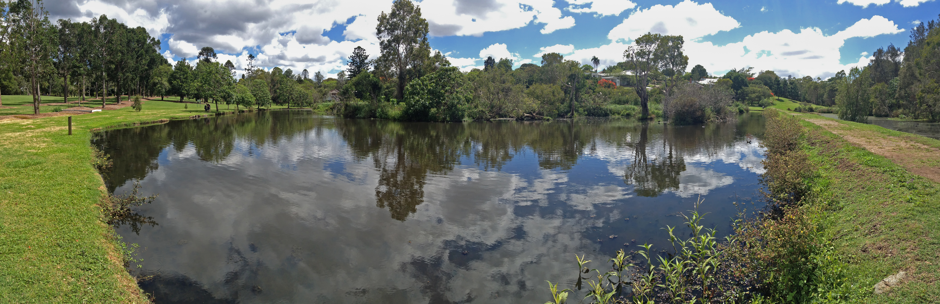
Figure 1. The site in 2014, 5 years prior to works, showing the lack of wetland fringing vegetation due to it being regularly brushcut. (Photo Friends of Sherwood Arboretum)

Sherwood Arboretum, 15 hectares in size, contains a collection of planted (specimen) Queensland native trees under the supervision of Brisbane Botanic Gardens. Located in the suburb of Sherwood in Brisbane, the Arboretum has the Brisbane River as its western boundary and there are three small watercourses running both into and out of two lakes, providing habitat for wildlife. Before the development of the Arboretum in 1925, the lakes were a single paperbark swamp with small patches of open water. An early city water main ran across the swamp roughly dividing it in two. In 1975 the water main was covered by rocks and soil to form a causeway/walking path, and the swamp was reshaped to form two open lakes containing three islands. Many species of birds use the lakes, the watercourses, and the Arboretum as a whole, gathering and dispersing according to season or changes in management.

Prior to the commencement of regeneration treatments the edges of the lake were relatively barren (Fig 1), kept in this condition by regular mowing and brushcutting which led to occasional collapses of the edges into the lake.  Close inspection found around 14 natives among the weeds being mowed and brushcut; so the idea came that perhaps the natives could be allowed to grow and protect the edge.  This would also form a natural plant community and potential faunal habitat. Twenty weed species were observed, including Signal Grass (Brachiaria decumbens), Green Panic (Megathyrsus maximus var. pubiglumis), Bahia Grass (Paspalum notatum), Slender Pigeon Grass (Setaria parviflora), Blue Couch (Digitaria didactyla), Blue Billy Goat Weed (Ageratum houstonianium), Creeping Indigo (Indigofera spicata).

Works undertaken. In 2019, agreement was reached to discontinue mowing to the edge and brushcutting, and to trial bush regeneration-style weed management along a manageable portion of the lake edge; that is, both sides of the causeway.  The work was carried out by two members of the Friends of Sherwood Arboretum bushcare group, a Habitat Brisbane bushcare group which is supported by Brisbane City Council.   The two volunteers worked on a weekly basis over 4 years, gradually removing weeds to release native plants.  The technique involved weed removal prior to weed seed shed while allowing natives to seed.  The objective was to reduce weed soil seed banks and recharge native soil seed banks over time.

Figure 2. The north-west corner of the causeway in 2021 showing high density natives, particularly Willow Primrose. (Photo Gordon King)

Results to date. As weed cover declined markedly, natives increasingly reappeared, dominating the site within two years.  At the peak of the site’s recovery, 34 native wetland herbaceous species had returned – many of these in high abundance in particular locations Figs 2-7).  These particularly included Tassle Sedge (Carex facsicularis), Emu Foot (Cullen tenax), Narrrow-leaved Indigo (Indigofera linifolia), Common Rush (Juncus usitatus), Willow Primrose (Ludwigia octovalvis), Slender Knotweed (Persicaria decipiens), Spotted Knotweed (Persicaria strigosa) and Poison Pratia (Lobelia concolor).

Water birds that also graze on land have been observed by the regeneration team to be increasingly using the lake edges – including Purple Swamphen (Porphyrio melanotus), Wood Duck (Chenonetta jubata) (Fig 6), Dusky Moorhen (Gallinula tenebrosa) and Intermediate Egret (Ardea intermedia).  The wetland plant insect life has also increased in the recovered areas.  As a result, the Chequered Swallowtail Butterfly (Papilio demoleus) (Fig. 7) is now seen among the Emu Foot, one of its host plants.

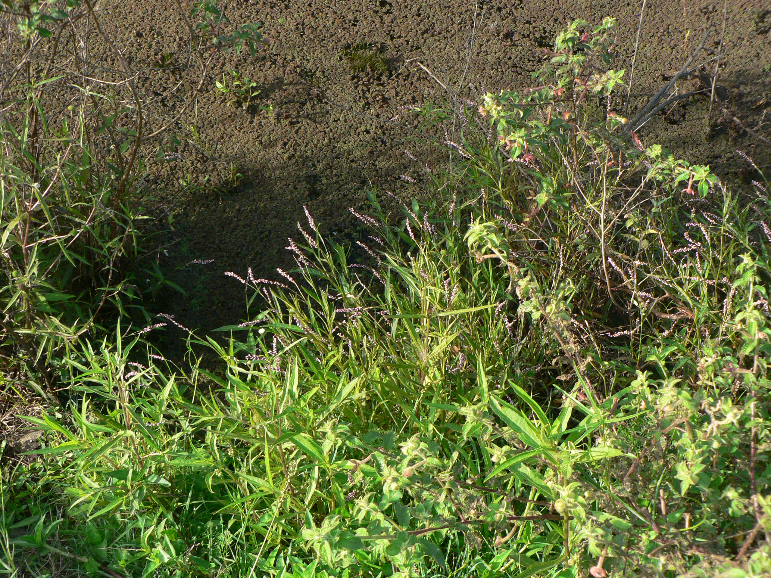
Figure 3. General view with White Eclipta (Eclipta prostrata), Slender Knotweed, Willow Primrose, Commelina (Commelina sp.) and Azolla (Azolla sp.) (Photo Gordon King)

Figure 4. Emu Foot. One of the natives tenaciously surviving even when there was a heavy weed presence. (Insets are of the characteristic five leaflets and the inflorescence.) (Photos Gordon King.)

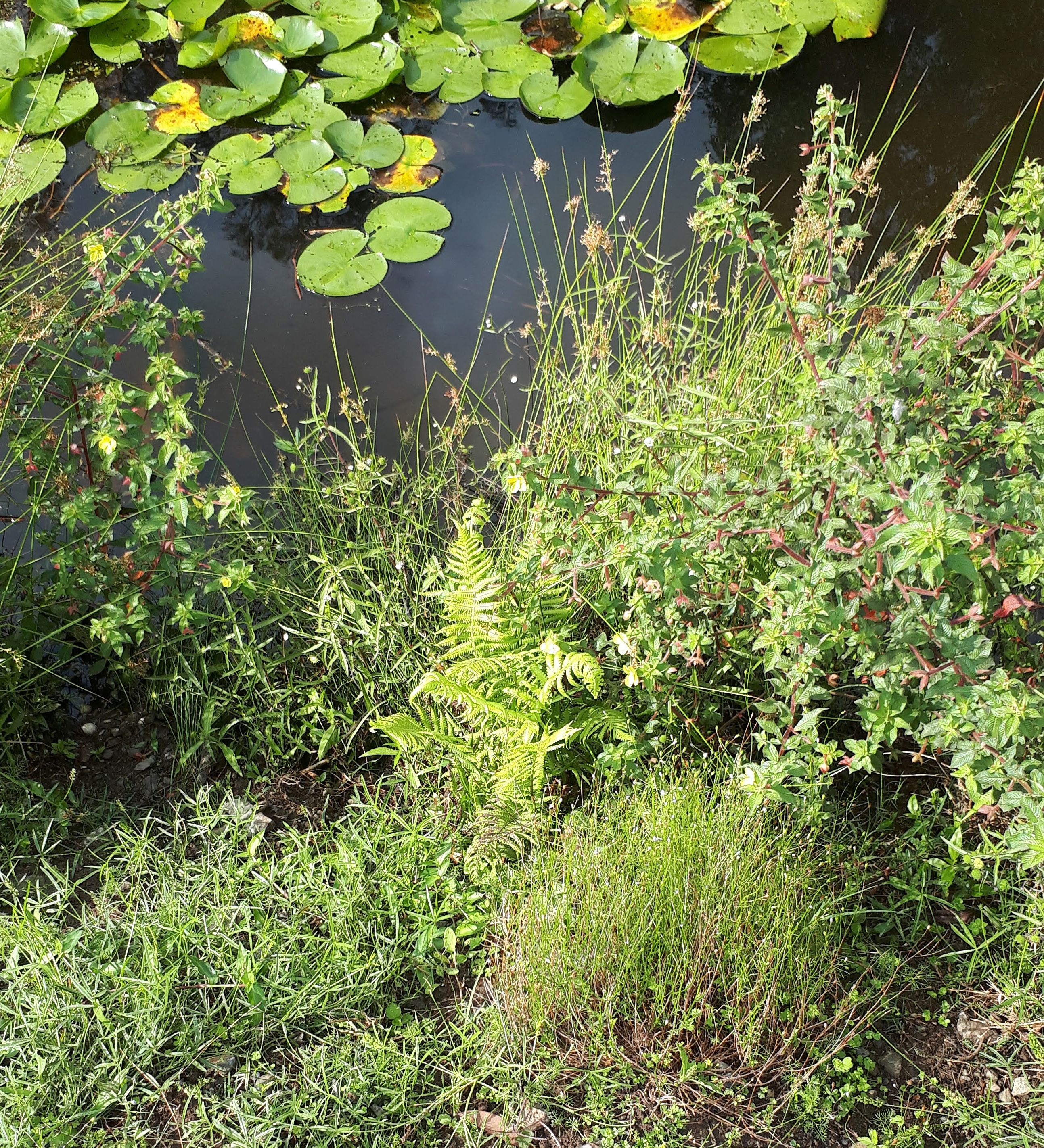
Figure 5. Diversity of native species is high in some places – such as pictured here where Willow Primrose, Common Reed, White Eclipta, Binung (Christella dentata), Sprawling Bluebell (Wahlenbergia gracilis) and Emu Foot occur in close proximity. The waterlily is the introduced Mexican Waterlily (Nymphaea mexicana) and is controlled from time to time. (Photo Gordon King)

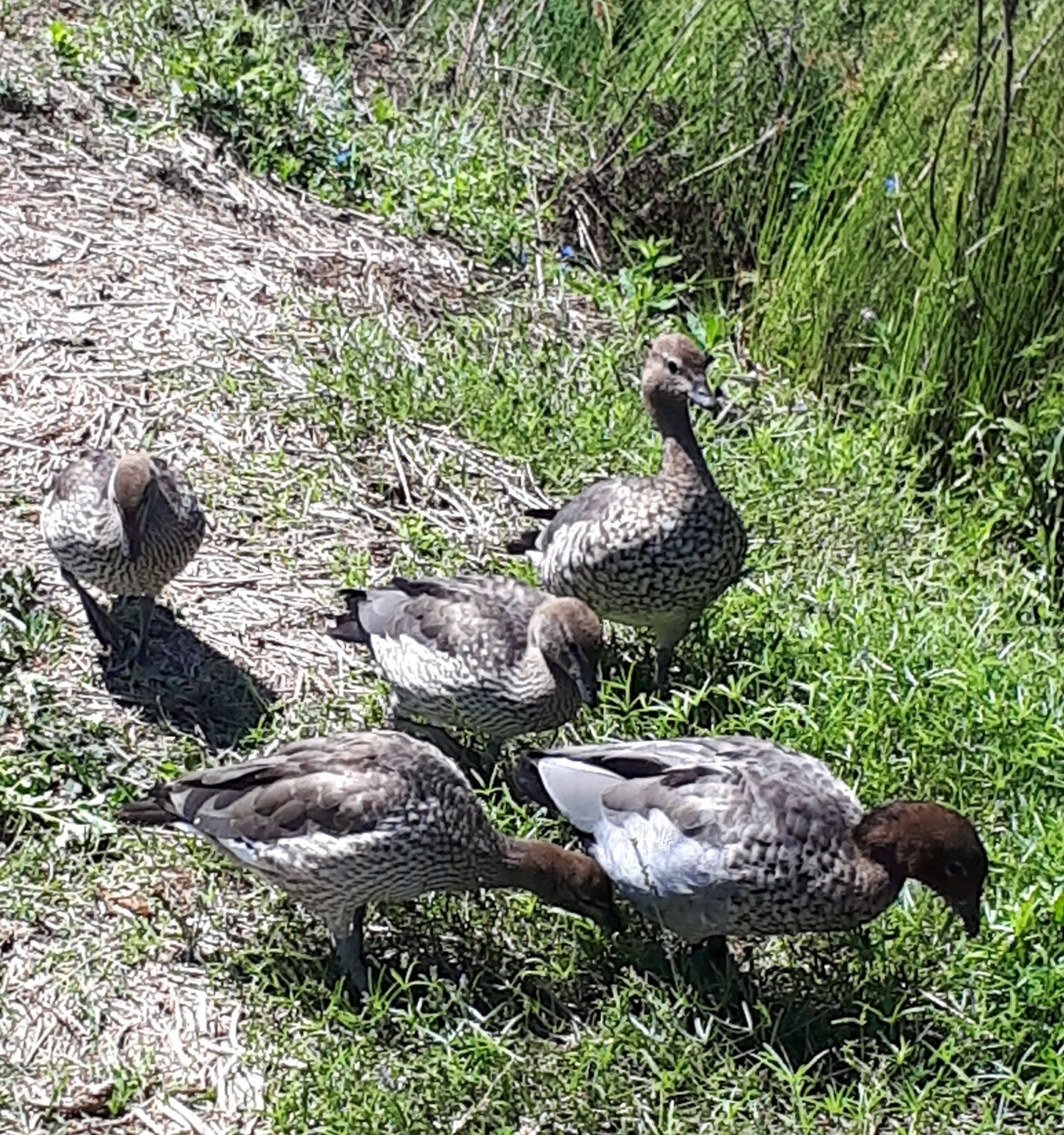
Figure 6. Wood Ducks foraging along the regenerating lake edges. (Photo Gordon King)

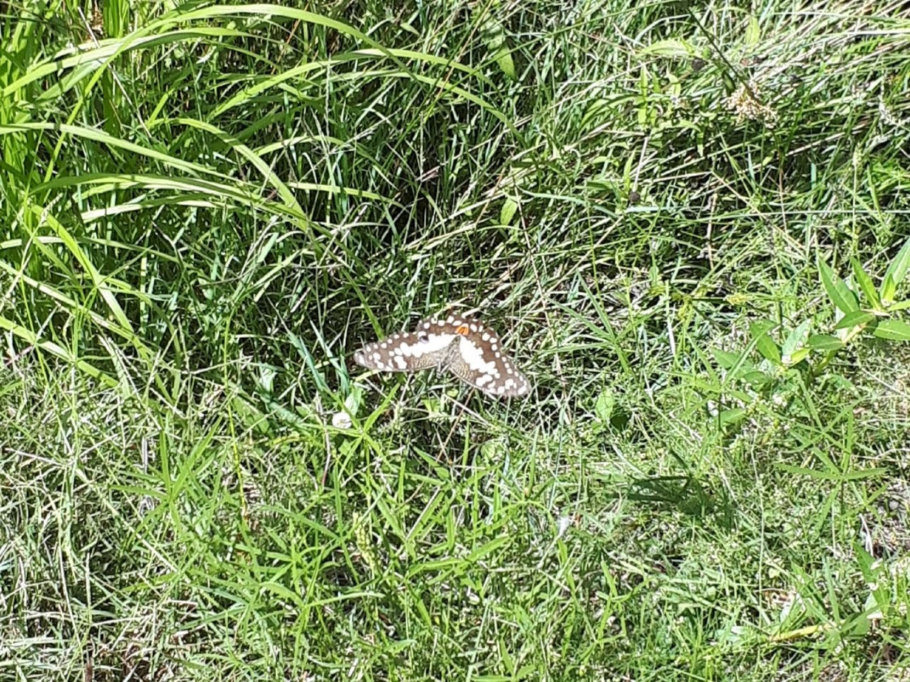
Figure 7. Insect life has increased including the Chequered Swallowtail butterfly for which Emu Foot is a host plant. (Photo Gordon King)

Changes over time. Composition has proven to be seasonally variable. At one point when the water had reduced to a very low level in the lake, muddy edges appeared, and Bacopa (Bacopa monniera.) emerged and flowered. A few days later there was rain and the water rose and covered the flowering plants – which are unlikely to return until muddy edges reappear. More recently, with heavy rains in February 2022, floodwaters covered all the banks to a depth of over 1m for several days.  Many species were severely affected, particularly Willow Primrose.  However a good recovery of all species is occurring.

A notable result of the work has been that the lake edges are no longer eroding and it is clear that valuable new habitat has been created.  These results provide more positive options for future management of the more extended lake edge should habitat restoration be undertaken in the future. It is an inspiring project to be involved in.

Acknowledgements: Brisbane Botanic Gardens and Brisbane City Council Habitat Brisbane program for agreeing to try this process. The Habitat Brisbane program also helped with occasional contractor support. Also thanks are extended to Gordon King, for his unflagging effort as fellow worker and for the use of his photographs.

Contact: Carole Bristow, bushcare leader, Friends of Sherwood Arboretum bristowc@bigpond.net.au

Waterponding the Marra Creek, NSW rangelands – UPDATE of EMR feature

Ray Thompson and Central West Local Land Services

[Update of EMR feature – Thompson, Ray F (2008) Waterponding: Reclamation technique for scalded duplex soils in western New South Wales rangelands. Ecological Management & Restoration 9:3, 170-181. https://onlinelibrary.wiley.com/doi/10.1111/j.1442-8903.2008.00415.x]

Figure 1.  Scalded country with 30cm of sandy loam topsoil swept away by wind after extensive overgrazing. (Photos NSW SCS)

Introduction. Overgrazing of native pastures in the second half of the 19th Century stripped vegetation and led to the wind erosion of sandy topsoil during inevitable dry periods.  By the 1960s, tens of thousands of square kilometres of rangeland sites in western NSW had a legacy of moderate or severely bare or ‘scalded’ lands. This left bare and relatively impermeable clay subsoil which prevents water penetration and is very difficult for plants to colonize (Fig 1.)

Waterponding is the holding of water on the scald in surveyed horseshoe-shaped banks, each covering 0.4 ha. The ponds retain up to 10 cm of water after rain which leaches the soluble salts from the scalded surface. This improves the remaining soil structure, inducing surface cracking, better water penetration and entrapment of wind-blown seed. Consequently, niches are formed for the germination of this seed and recovery of a range of (typically around 15 out of a total of about 30) locally native chenopod (saltbush) grassland species on the sites.

The original 2008 EMR feature described how barren scalds at a range of properties in Marra Creek, near Nyngan in semi-arid NSW were transformed during the 1980s and 1990s into biodiverse native pastures through a technique called ‘waterponding’ developed after five decades of work by consecutive soil conservation officers exploring a range of prototype treatments.  Over time, a wide range of machines have been used to construct waterponding banks including standard road graders (ridged frame and articulated) or similar. Pre-1985 road graders were generally too small to construct banks of sufficient size, which resulted in too many breached banks. Over a 4-year period, the Marra Creek Waterponding Demonstration Program, backed by committed landowners, researched different horsepower road graders, constructing different size banks, winning the dirt from different locations, and evaluating the economics of construction methods. The results showed that the higher-powered articulated road graders exceeding 200 HP proved to be the most economical and efficient for waterpond construction. This type of machine has the power to  form the bank with one pass on the inside of the bank and two passes on the outside, achieving a bank with well over 2 m base width and over 60 cm in height (Fig. 2).

Figure 2. The process of of waterponding including (a) ute-mounted laser levelling to design the waterpond for a particular site, (b) bulldozing the pond walls to the designed levels, (c) rainfall filling the pond to allow deep watering and cracking of the clay subsoil and (d) resulting revegetation within the walls of the pond. (Photos NSW SCS)

Update and the broader program.  Photos and pasture measurements undertaken on ‘Billabong’ Marra Creek NSW, till 2014 show that the waterponding site had increased ground cover (predominantly native species) from 1% in 2005 to 84 % in 2014. After five to seven rainfall years a typical treatment can result in recovery of up to 15 native species from a range of up to 31 species (Table 1). The method in the last 20 years has also included broadcasting seed of some of the more important perennial species of healthy native chenopod grasslands including  Oldman  Saltbush  (Atriplex nummularia), Bladder Saltbush (Atriplex vesicaria) and Mitchell Grass (Astrebla   lappacea) (Fig 3).  Landholders in the Marra Creek district observe a range of fauna frequently on and between the ponds, including Western Grey Kangaroo (Macropus fuliginosus), Red Kangaroo (Macropus rufus), Emu (Dromaius novaehollandiae), Brolga (Grus rubicunda) and the Eastern Bluetongue Lizard (Tiliqua scincoides). A species of Monitor (Varanus sp.) also sometimes traverses the waterponds. Formal monitoring of smaller reptile and invertebrate use of waterponded sites is yet to occur.

Figure 3. Curly Mitchell Grass (Astrebla lappacea) sown on pond banks. (Photo NSW SCS)

Marra Creek was not the first series of waterponding programs in the Nyngan area – nor the last. The outputs of the entire program by 2019 included over 80,000 waterponds laid out and constructed, resulting in 40,000 hectares returned to local native vegetation. A total of 164 properties in the rangelands area are now using waterponding, the majority of landholders in the Marra Creek district and representing an increase from 17 landholders back in 1984 when we first ran the waterponding.

Figure 4. Landholders themselves are teaching the Waterponding technique to other landholders. (Photos NSW SCS)

Economic model of waterponding. The primary driver for land reclamation was not biodiversity conservation but returning the natural capital of rangelands. As such the program has returned a clear profit to the landholders in terms of increased native pastures that can be grazed, improving ecologically sustainable income sources for farming families.

With the reinstatement of vegetation, there have be increases in total stock feed, resulting in an increase in lambing percentages and wool cuts, as well as the ability to carry stock further into prolonged dry periods with overhead cost per head remaining static. Once rehabilitation has been completed, stocking  rates have been raised from zero to one sheep to 1.5 ha. This iseffectively the long-term grazing average for  saltbush pastures in the Nyngan district.

A treatment involving the full design and survey, pond construction and revegetation cost the landholder about $144.00 per hectare. (This includes approximately $25 a hectare for seed.) If the landholder does all the work the cost is reduced to $72/ha. The type of land involved was calculated in 2008 to normally  have  a  resale  value  of  about $365.00 per hectare In its unproductive state.  Scalded land does not contribute to the farm income yet still incurs rates. Investment in rehabilitation, in contrast, improves carrying capacity thus reducing hand-feeding costs, improving lambing percentages and avoiding forced stock sales. This allows landholders to pass the property to the next generation in a far better condition than it has been previously.

Research has found that the scalds store approximately 18.7 t/h of soil organic carbon to a depth of 30 cm. Once the landscape has been restored by waterponding and revegetation, we have found there is a rapid increase in soil organic carbon up to 25 t/ha within five years. The results are indicating that land in the rangelands that has been rehabilitated using waterponds does sequester carbon. This could lead on to waterponding being eligible for a carbon abatement activity and hopefully lead to Carbon Farming Initiative activity for carbon credits.

Figure 5. Australian National University students attending ‘21 years of participation in Rangelands Waterponding’. (Photos NSW SCS)

Potential for further application. After decades of field days and uptake of the methodologies by local graziers (Fig. 4), waterponding now forms part of standard district farming methodologies and landholders are now passing on knowledge to new generations, including through universities (Fig. 5). The methodologies have also been applied at one national park and one Trust For Nature site in Victoria, and are being applied in the Kimberley, with potential for far greater application in desert conservation reserves throughout Australia and the rest of the world (See Fig. 6 and https://justdiggit.org/approach-2/#).

Contact. Kyra Roach, Central West Local Land Services, Nyngan, 2825 Australia. Email: kyra.roach@lls.nsw.gov.au

Figure 6. A total of 79 trainees from 26 Africa countries (including Ghana, Tunisia, Rwanda, Burundi and Djibouti) over a three year period were sponsored by AusAid to study waterponding in Nyngan. Resullting work in African countries is making a big difference to degraded lands particularly in North Sudan and Kenya (Photo NSW SCS)

Table 1. Species found in waterponds after standard revegetation treatments and five to seven rainfall years. The species found by Rhodes (1987b) are still commonly found, with additional species (marked with a diamond +) observed by Ray Thompson. (Plant names are consistent with the New South Wales Herbarium database PlantNet, http://plantnet.rbgsyd.nsw.gov.au/ and  growth forms are consistent with Cunningham et al. (1981) (Exotics are marked with an asterisk)

Scientific name Common name Growth form
Alternanthera denticulata Lesser Joyweed Annual forb
Astrebla lappacea+ Curly Mitchell Grass Perennial grass
Atriplex leptocarpa Slender-fruited Saltbush Perennial subshrub
Atriplex lindleyi+ Eastern Flat Top Saltbush Annual subshrub
Atriplex nummularia+ Oldman Saltbush Perennial shrub
Atriplex pseudocampanulata Mealy Saltbush Annual subshrub
Atriplex semibaccata+ Creeping Saltbush Perennial subshrub
Atriplex spongiosa Pop Saltbush Annual forb
Atriplex vesicaria Bladder Saltbush Perennial subshrub
Centipeda thespidioides Desert Sneezeweed Perennial forb
Chamaesyce drummondii Caustic Weed Annual or short-lived perennial forb
Chloris truncata Windmill Grass Annual or perennial grass
Diplachne fusca Brown Beetle Grass Perennial grass
Eragrostis parviflora Weeping Lovegrass Annual or short-lived perennial grass
Eragrostis setifolia Neverfail Perennial grass
Hordeum leporinum* Barley Grass Annual grass
Hordeum marinum* Sea Barley Annual grass
Maireana pentagona Hairy Bluebush Perennial subshrub
Malacocera tricornis Soft Horns Perennial subshrub
Marsilea drummondii Common Nardoo Perennial forb
Medicago minima* Woolly Bur Medic Annual forb
Medicago polymorpha* Burr Medic Annual forb
Osteocarpum acropterum+ Water Weed Perennial subshrub
Phalaris paradoxa* Paradoxa Grass Annual grass
Pimelea simplex Desert Rice-flower Annual forb
Portulaca oleracea Common Pigweed Annual forb
Salsola kali var. kali Buckbush Annual or biennial forb
Sclerolaena brachyptera Short-winged Copperburr Short-lived perennia
Sclerolaena calcarata+ Red Copperburr Perennial subshrub
Sclerolaena divaricata+ Pale Poverty Bush Perennial subshrub
Sclerolaena muricata Black Roly-poly Short-lived perennial
Sclerolaena trycuspis Streaked Poverty Bush Perennial subshrub
Sporobolus actinocladus Katoora Grass Perennial grass
Sporobolus caroli Fairy Grass Perennial grass
Tragus australianus Small Burr Grass Annual grass
Tripogon loliiformis+ Five Minute Grass Perennial grass


Rehabilitation of former Snowy Scheme Sites in Kosciuszko National Park – UPDATE of EMR feature 2019.

Gabriel Wilks

Update of EMR feature – MacPhee, Elizabeth and Gabriel Wilks (2013) Rehabilitation of former Snowy Scheme Sites in Kosciuszko National Park.  Ecological Management & Restoration, 14:3, 159-171. Doi https://onlinelibrary.wiley.com/doi/10.1111/emr.12067

Key words.  Habitat construction, steep slopes, rock spoil.

Figure 1. Shaped rock spoil ready for planting more than 50 years after being dumped.

Introduction. Our original EMR feature article described the origins of this large, long-term rehabilitation program and the challenges faced in the first 10 years. The program’s aim was to address a range of impacts upon montane and sub-alpine vegetation and river corridors in Kosciuszko National Park from the Snowy Hydro Scheme, constructed from 1949 to 1974. Impacts included dumping of large volumes of rock spoil, loss of topsoil and native vegetation, introduction and spread of weeds and asbestos fragments in the landscape.  The article outlined the development of methodologies for restoration, particularly planting trials on steep rock spoils, and how obstacles such as slope instability, plant material availability and lack of soil were being overcome. The process of program implementation was given, including environmental and cultural heritage assessments undertaken as part of site works.  In 2013 a number of positive outcomes were already evident at the 200 sites that had been subjected to at least some treatment, including 18 sites where major rehabilitation works were undertaken. Outcomes included reduction in waterway impacts and invasive weeds, expansion of the Kosciuszko fauna database, regional community benefits, and production of an Australian Alps Rehabilitation Field Guide.

Further work. The Former Snowy Scheme Rehabilitation Program continues to reduce the long term environmental and safety risks of old degraded construction sites to Kosciuszko National Park, as well as improve their visual and ecological function. Some sites treated by 2013 have blended in with the surrounding landscape and are difficult to identify. Many sites are continuing to improve in condition over time, with distinct vegetation layers, natural plant recruitment and evidence of native fauna habitat. Construction history, rock spoil and loss of soil and plant species remain evident at highly altered sites, despite a high standard of rehabilitation work.

An additional 12 Major rehabilitation works have been undertaken since 2013, with selected signature projects and rehabilitation techniques described below.  Note that the former Snowy Scheme rehabilitation program does not address the impact of current Snowy Hydro Limited or proposed infrastructure and support networks such as powerlines, easements, river regulation or roads.

1. Rehabilitation of the Tooma–Tumut Access Tunnel Adit Spoil Dump. This spoil dump (Fig. 1) is located on the highly incised upper reaches of the Tumut River.  The spoil originates from construction in 1958-1961 of the Eucumbene–Tumut Tunnel, which transfers the headwaters of the Tooma River to Tumut Pond. Following earthworks in 2017, the planting crew successfully planted, watered, fertilised and mulched approximately 12,000 plants on rock spoil, with monitoring being undertaken by Greening Australia Capital Region staff (Fig 2.)

Figure 2. Year 1 Revegetation monitoring at Tooma-Tumut SD by Greening Australia Capital Region staff, 2018

2. Construction of contained habitat for the Southern Corroboree Frog. A series of remote enclosures (Fig 3) have been constructed in both rehabilitation areas and former habitat locations to enable re-introduction of this Critically Endangered species (Fig 4), following the devastating impacts of chytrid disease. These enclosures are developing essential stepping stones for frogs from captive breeding programs to move back into the wild. Design of enclosures requires ensuring self-sustaining food and water, shallow ponds for breeding, ability for Threatened Species staff to monitor and control disease and exclusion of other frogs. These works have been done in partnership with NSW Threatened Species staff and zoo institutions.

Figure 3. Constructing Southern Corroboree Frog enclosures in remote locations

Figure 4. Southern Corroboree Frogs living successfully back in Kosciuszko

3. First live record of Smoky Mouse in Kosciuszko National Park. The Smoky Mouse (Pseudomys fumeus Fig. 5) was found alive and well for the first time in Kosciuszko National Park, at a Happy Jacks rehabilitation site. Up until the discovery, the only currently known population of the small, smoky grey coloured mouse still surviving in NSW was in the Nullica area, NSW South Coast.  Three individuals, 2 males and 1 female were a significant find for survival and database records of this Critically Endangered Species, and a technical short note was published in EMR in 2017 by fauna surveyor Martin Schulz who found the animals.

Figure 5. A Happy Jacks Smoky Mouse.

4. Making people and places safer with rehabilitation. Sites that housed construction depots and townships during Snowy scheme construction still contained fragments of asbestos which were rapidly degrading due to weather exposure. As total removal was not feasible, the rehabilitation team worked with asbestos experts to develop practical measures to reduce public safety risks. At the remote Junction Shaft Contractors Camp (at Happy Jacks, Figs 6 and 7) and a former township and current camping ground at Island Bend a range of techniques were developed, delineation of zones for suitable uses, creating natural vegetation buffers and capping with rock spoil and plants.

Figure 6. The Junction Shaft Camp in 1955.

Figure 7. The same site 62 years later (and one year after works) with a range of capping and planting zones, including a heli-pad, Mountain Pygmy Possum habitat, and new plantings to improve safety and environment.

5.  Applying techniques beyond Kosci. Project team members took some winter time out of Kosciuszko to ‘grow’ a protection zone for a known population of Endangered Green and Golden Bell Frog (Litoria aurea) and constructed a series of ponds for future breeding in an old sand quarry at Worrigee Nature Reserve, Nowra (Fig 8). Given former quarries are a feature of a large infrastructure project such as the Snowy Scheme, the team had the technical knowledge for how to restore ecological function despite a radical departure from usual flora and fauna species. A range of techniques including neighborhood consultation, barrier logs and blocks, berms and vegetation were used to reduce the impact of recreational and unauthorised motorbikes and rubbish dumping.

Figure 8. Creating Bell Frog habitat in degraded borrow pits.

6. Growing rehabilitation resources and protecting karst ecosystems. The use of treated waste at the Yarrangobilly Caves visitor precinct to grow snow grasses (Poa spp.) for use in rehabilitation projects across Kosciuszko and been continued and developed (Fig. 9). A renewed emphasis on site production has enabled Poa seed to be available for other projects within the Park. This provides an ecologically preferable option for soil stabilisation and ground cover establishment, reducing the risk of weed invasion and dependence on sterile rye corn as the only available option.

Figure 9. Inspecting plants for seed harvest, which yielded 52 kgs of Poa seed in 2017.

Lessons Learned. It is clear that this is a unique rehabilitation project due to the large number of sites, the natural and heritage values of Kosciuszko National Park and the longevity and continuity of the commitment (approx. 20 years).  Understandably, however, at this point in time challenges in rehabilitation remain. ‘Off the shelf’ rehabilitation products are limited due to remoteness of locations, plant species required, Park management policies and required hygiene protocols. It is important that additional threats are not accidentally introduced, such as foreign pathogens and flora and fauna. As much as possible, resources such as coarse woody debris, woodchip, plant material and compost are sourced from within the Park. A flexible and dynamic approach to the very definition of rehabilitation and techniques and materials is required.  Specific lessons include the following.

Adding organic material on degraded sites is always beneficial. Rehabilitation success has been most obvious where logs, litter, woodchip and straw have been added to the site, to provide mico-niche climate, habitat, and improve soil. While this may increase short term management requirements such as weed control, the commitment is worth it due to the improved results.

Creating compost from old sawmill sawdust has worked well for this rehabilitation project. The most recent development however is in the use of organics waste and treated effluent from visitation facilities as a compost, and there is opportunity for this on-Park recycling to develop.

Other resources such as rice straw have become limited during periods of sustained drought and less rice production. This will remain a challenge into the future. The value of minimising ground cover loss, retaining natural soil characteristics and organic matter in situ and ensuring rapid rehabilitation after disturbance in future developments will become increasingly important for rehabilitation success.

Be creative with team skills and capacity. Problems such asbestos contaminant presence must be addressed for safety, but doesn’t mean walking away from the challenge. A degraded site may be the perfect place to develop species targeted habitat.  Seek expertise advice and consider a range of current and new solutions.

ContactGabriel Wilks, Senior Project Officer, NPWS Southern Ranges Services. PO Box 472, Tumut NSW 2720.  Email: Gabriel.Wilks@environment.nsw.gov.au

Is revegetation in the Sheep Pen Creek area, Victoria, improving Grey-crowned Babbler habitat? – UPDATE of EMR feature

Doug Robinson

[Update of EMR feature Robinson, Doug (2006) Is revegetation in the Sheep Pen Creek area, Victoria, improving Grey‐crowned Babbler habitat?  Ecological Management & Restoration, 7:2, 93-104.  https://doi.org/10.1111/j.1442-8903.2006.00263.x]

Key words: (<5 words): Monitoring, restoration, population ecology, woodland conservation

Figure 1. Location of babbler project works and other landcare works implemented since 1996 in the Sheep Pen Creek Land Management Group area and the two sub-districts used for the babbler study. (Source TFNVic)

Introduction: The Grey-crowned Babbler (Pomatostomus temporalis) (babbler) is a threatened woodland bird (classified as Endangered in the state of Victoria) that has declined substantially in overall distribution and abundance across much of its former range in southeastern Australia since European settlement.  Sheep Pen Creek Land Management Group area, in northern Victoria (Fig 1), was fortuitously the location of the largest known remaining babbler population in Victoria in the early 1990s (when this project began); and the focus of extensive land restoration programs from the 1980s onwards to help mitigate the impacts of erosion and dryland salinity, as well as biodiversity decline.  The original study, published in 2006, investigated the overall changes in tree cover across the district between 1971 and 1996 as a result of different land-management actions and responses of local babbler populations to those habitat changes.  The key finding was that in the Koonda sub-district which had a 5% overall increase in tree cover to 14% from 1971 to 2001, showed an increase in babbler numbers by about 30% (Table 1).   In the Tamleugh sub-district, tree cover increased by 1.3% to a total of 9%, with no change in babbler numbers.  The findings also showed that new babbler groups were preferentially colonizing new patches of vegetation established that suited their habitat needs.  Building on this research, the study concluded that future conservation programs needed to scale-up the extent of habitat restoration, target areas which were suitable for babbler colonization, and tailor incentive programs to assist with conservation of particular species.

Table 1. Changes in Grey-crowned Babbler numbers over time

Year Koonda Tamleugh
number of groups number of birds number of groups number of birds
1992 20 78 11 39
1993 20 89 10 34
1996 24 96 9 35
1997 24 102 8 30
1998 25 99 10 40
2000 26 97 10 43
2005 23 99 8 34

Further revegetation works undertaken. Since the initial study’s assessment of vegetation changes between 1971 and 1996, an additional 133 ha of vegetation has been restored or established as babbler habitat in Koonda district and 37 ha in the Tamleugh district (Figs 2 and 3, Table 2).  Extensive natural regeneration, supplemented by broadscale revegetation, has also occurred over more than 350 ha on five private conservation properties in the Koonda district,, contributing to substantial landscape change.  The wider landscape has also been identified as a statewide priority for nature conservation on private land, leading to increased conservation investment in permanent protection there by Victoria’s lead covenanting body – Trust for Nature.

Monitoring of outcomes: The monitoring that was carried out prior to the 2006 publication has not continued, leaving a knowledge gap as to how the population has fared in the context of the Millenium Drought and ongoing climate-change impacts. However, based on the original research’s initial findings, we conducted an experimental study with University of Melbourne to evaluate the effectiveness of habitat restoration in maintaining babbler survival. The study, published by Vesk and colleagues in 2015, compared the persistence and group size of babbler groups present in 1995 and subsequently in 2008 at a randomly selected set of stratified sites which had either had habitat works or none.  This study was conducted across a larger landscape of about 200,000 hectares which included Sheep Pen Creek Land Management Group area.  The study found that babbler group size decreased by about 15% over the 13 years at sites without restoration works.   At sites with restoration, average group size increased by about 22%, thereby effectively compensating for the overall reduction in numbers reported over that time.This increase also influenced subsequent demographic performance, with groups at restoration sites having higher breeding success and more fledglings than groups at control sites.

Another useful finding from this experimental study was the confirmation of the importance of particular habitat and landscape variables on babbler persistence.  In particular, abundance of large trees was a positive predictor of occupancy over time; and distance from the next nearest group was a negative predictor.

Figure 2. Changes in tree cover in the Koonda sub-district between 1971 (top),  and 2018 (bottom). (Source TFNVic).. (Source TFNVic)

Figure 3. Changes in tree cover in the Tamleugh sub-district between 1971 (top) and 2018 (bottom). (Source TFNVic)

Table 2.  Summary of additional habitat established or restored as part of the Sheep Pen Creek Grey-crowned Babbler project from 1996-2018, following the initial study period from 1971-1996.

District Number of sites Area (ha)
Koonda 62 133
Tamleugh 28   37
Other parts of landcare group and local babbler population area 29 103
Totals 119 273

Expansion of lessons to other districts: Building on the fundamental research conducted in Sheep Pen Creek Land Management Group area, similar habitat, landscape and babbler population assessments were subsequently undertaken in northwest Victoria near Kerang for the babbler populations found there.  Key results from these studies relevant to the initial Sheep Pen study were that the number of babbler groups in each sampled district was positively related to the proportion of woodland cover, especially the proportion of Black Box (Eucalyptus largiflorens) woodland habitat – the babblers’ preferred habitat in this region.  Conversely, the number of babbler groups was negatively associated with the proportion of land under intensive agriculture.  At the site scale, key positive predictors of babbler presence in Black Box habitat again included the abundance of large trees (> 60 cm dbh)

Lessons learned and future directions: The most valuable lesson learned since the initial paper was published was the power of the structured research project described above to evaluate the effectiveness of the babbler conservation program and inform future design and planning. The study further demonstrated the importance of taking a demographic approach to the species’ conservation needs, understanding what is happening across the whole population over time  and how habitat interventions can assist.  These lessons have since been applied usefully to other babbler projects  and more broadly to conservation of woodland birds.

The initial paper noted the importance of achieving landscape-scale change in vegetation extent, particularly in more fertile habitats. This has occurred to some extent within the Koonda district through a range of incentive programs, tender programs, covenanting programs and land purchase, but continues to achieve most gains on more infertile land. On fertile land, by contrast, there has been rapid land-use change to cropping over the past fifteen years, leading to reduced likelihood of those properties providing suitable habitat for babblers, as found in the study conducted in northwest Victoria.

The initial paper also suggested the benefit of developing tailored incentive programs for babblers and other threatened species with particular requirements to maximize potential conservation gains  and we suggest, based on Australian and overseas experiences,  that more specific incentive programs or more detailed criteria could assist.

Another important lesson learned was the difficulty in maintaining community-driven citizen-science monitoring, even with the best will in the world, without some over-arching organizational support and oversight.  We know that community monitoring for biodiversity conservation needs scientific input at the design and analysis stages; hence additional resources may also be required in terms of equipment or guidelines to help groups monitor effectively.  Modest government investments to conservation organisations with established biodiversity monitoring programs could usefully help address this issue.

Finally, the learnings from the Sheep Pen Creek Land Management babbler conservation project over nearly thirty years are that the landscape changes and that these changes are not always positive.  Land-use change is placing more pressure on  potential babbler habitat; and the eucalypt regrowth which was established and provided new nesting resources for a few years is now too tall to provide nesting habitat, but too dense and immature to provide suitable foraging habitat for another one hundred years.  Climate change is rapidly imposing constraints on the availability of food resources and breeding opportunities, exacerbated by increased competition for the same limited resources by exotic and native species.  For the Grey-crowned Babbler, the solution to all of these factors depends on ongoing commitment to the establishment or maintenance of their essential habitat needs and life-history requirements so that their life-cycle is provisioned for from generation to generation.

Stakeholders and Funding bodies:   Most of the targeted habitat works achieved for babblers in this landscape has occurred through funding support from the Australian government through its Natural Heritage Trust and Caring for our Country programs.  Broader habitat protection and restoration has occurred primarily with funding support to landholders from the Goulburn Broken Catchment Management Authority (GBCMA).  The Norman Wettenhall Foundation, along with GBCMA, was instrumental in enabling the research by University of Melbourne, which was also aided by the extensive voluntary support of Friends of the Grey-crowned Babbler.  Not least, local landholders continued to support the project and continue to protect or restore parts of their properties to assist with babbler conservation.

Contact information: [Doug Robinson, Trust for Nature, 5/379 Collins Street Melbourne, Victoria 3000, Australia.  dougr@tfn.org.au, (03) 86315800 or 0408512441; and  School of Life Sciences, La Trobe University, Bundoora, Victoria, Australia.


Restoring wetland communities in the Coorong and Lower Lakes, South Australia

[Summary will be reinstated soon.]

Recovering biodiversity at Trust for Nature’s Neds Corner Station, Victoria

Doug Robinson, Deanna Marshall, Peter Barnes and Colleen Barnes

Key words. Private conservation area, natural regeneration, ecological restoration, rabbit control.

Introduction. Neds Corner Station is Victoria’s largest private conservation property. This 30,000 hectare ex-sheep and cattle station was purchased for nature conservation by Trust for Nature (Victoria) in 2002.

The property occupies the driest area of the state with an average annual rainfall of only 250 mm. As such, it has strong ecological links to the arid regions of Australia and Australia’s rangelands. Neds Corner sits strategically at the hub of an extensive network of public and private conservation lands bordering or close to the Murray River in Victoria, New South Wales and South Australia. The reserve is bordered on three sides by the Murray Sunset National Park and borders frontages along the Murray River and associated anabranches for more than thirty kilometres, where the River Red Gum (Eucalyptus camaldulensis) dominated riparian zone connects with Chenopod Shrublands, Semi-arid Chenopod Woodlands and Chenopod Mallee Woodlands. Trust for Nature’s restoration efforts are targeted at restoring woodland connectivity across the property to improve habitat extent and condition for woodland and mallee plants and animals, including the nationally threatened Regent Parrot (Polytelis anthopeplus). A biodiversity survey in 2011 found 884 native species at Neds Corner Station, including 6 threatened birds and animals, 77 threatened plants, and 21 species new to science. Trust for Nature continues to find new records for the property.

Fig 1 Neds 2003

Fig. 1. Highly degraded area (near watering points) in 2003 just after Trust purchased the property.


Fig 2 Neds 2011

Fig. 2. Same photopoint in 2014 showing extensive natural regeneration of Low Chenopod Shrubland after removal of livestock and extensive treatment of rabbits.


Planning for recovery. In 2002, when Trust for Nature first took on the property, the land was severely degraded from continuous over grazing by stock, rabbits and native herbivores; weed infestations; historic clearing of extensive areas of woodland for firewood and forage; and lack of flooding. Native vegetation was sparse over much of the property, soil erosion was extensive and the floodplain and semi-arid woodlands were all showing signs of extreme stress.

In the early years of ownership, management focussed on addressing the most obvious of these threats, with a focus on rabbit control and weed control. In 2010, with funding support from The Nature Conservancy, Trust for Nature prepared a Conservation Action Plan for the reserve, using the Open Standards for Conservation process, and a subsequent management plan. These planning documents identified the key biodiversity values on the reserve, the major threats to these values and the strategies to reduce threats and improve condition to achieve agreed ecological goals.Fig 6 Neds

Fig. 3. Dune Wattle (Acacia ligulata) natural regeneration after cropping was discontinued.

Fig 7 Neds

 Fig 4. Hop Bush (Dodonaea viscosa) natural regeneration after cropping ceased.

Works undertaken. Trust for Nature’s first action was to remove the livestock to allow the regeneration and growth of native vegetation. Stock fencing was decommissioned to enable free movement of native fauna, and new exclosure fencing to protect sites of cultural and ecological significance were also constructed. Major efforts were made to reduce rabbit numbers through the use of warren ripping, fumigation and 1080 baiting across the property. To date, over 20,000 warrens have been treated. Direct seeding and tubestock planting in the Semi-arid Woodland areas of the property have been continuous, with the cessation of a cropping licence, over 500 ha direct seeded in one year as part of an Australian Government funded project. In partnership with the Mallee Catchment Management Authority, environmental water allocations have been used to inundate areas of Neds Corner, providing a vital lifeline to many of the plants and animals that inhabit the riverine billabongs and floodplain forests. Artificial water points and superfluous tracks have been closed. Targeted fox and other feral animal programs are continuous.

Fig 3 Neds 2003

Fig 5. Highly degraded ‘Pine paddock’ in 2003 just after the Trust purchased the property.

Fig 4 Neds 2011

Fig 6. Pine paddock from same photopoint in n2014 after exclosure fencing, rabbit control and extensive direct seeding of trees and shrubs in 2007 (and again in 2010). The grasses all naturally regenerated.

Results. In the 14 years since domestic stock removal and the ongoing control of rabbits and weeds, there has been a dramatic increase in the cover of native vegetation, notably from natural regeneration (Figs 1-4) but also from extensive supplementary planting and direct seeding (Figs 5-8). In 2011, wide spread natural germination of Murray Pines occurred across the woodland sections of the property and Sandhill Wattle (Acacia ligulata) seedlings were observed on one rise where no parent plant was known to occur, indicating a viable seed bank may exist. The vulnerable Darling Lilies (Crinum flaccidum) continue to extend their range, given favourable weather conditions and the continuous control of herbaceous threats to the extent required to ensure adequate recruitment of these key flora species. Bird surveys undertaken for one of the targeted projects within Neds Corner over the past 10 years show an encouraging increase in reporting rates of Brown Treecreeper (Climacteris picumnus victoriae) (>x2 increase), Chestnut-crowned Babbler (Pomatostomus ruficeps) (>x2% increase) and Red-capped Robin (Petroica goodenovii) (>x20 increase).

Fig 5 neds

Fig.7. Revegetation plantings in 2008

Fig 6 NEds 2014

Fig 8. Same revegetation planing line in 2013.

Current and future directions. Trust for Nature are due to revise their CAP and have identified the need to undertake recovery actions at a greater scale. They are currently investigating the feasibility of re-introducing some fauna species back into Neds Corner Station that haven’t been found in the region for decades, provided there is sufficient habitat to sustain them.

Acknowledgements. As a not-for-profit organisation, Trust for Nature (Victoria) relies on the generous support of many individuals, organisations and government entities. The main project partners to date include The Nature Conservancy, RE Ross Trust, Yulgilbar Foundation, Australian Government, Mallee Catchment Management Authority, Parks Victoria, Department of Environment, Land, Water & Planning, Mildura Rural City Council, Northern Mallee Region Landcare, Traditional Owners and the thousands of hours volunteers contribute to Neds Corner Station.

Contact: Doug Robinson, Conservation Science Coordinator, Trust for Nature: (Tel: +61 1800 99 99 33.) Email: dougr@tfn.org.au; www.trustfornature.org.au

Photos: Trust for Nature


Brush pack experiment in restoration: How small changes can avoid leakage of resources and underpin larger scale improvements for restoration and rehabilitation

David Tongway and John Ludwig

Key words: Landscape Function Analysis, biological foci, water harvesting, desertification, erosion

The following experiment illustrates how relatively small changes to redirect water flow can capture water and other biological resources at a restoration site. However the process occurs not only at the micro scale but cumulates to site and landscape scales, making it a primary underpinning principles of a method of site analysis, Landscape Function Analysis (LFA) that has been applied across Australia and other countries to assist land managers counter desertification by redesigning processes that regulate the flow of resources, minimise losses and foster cycling. See http://members.iinet.net.au/~lfa_procedures/

The LFA mindset and methodology involve a purposeful change of focus from listing the biota/ species present or absent at a site, to an examination of the degree to which biophysical processes deal with vital resources with respect to stresses arising from management and climatic events.

Fig 1 before

Fig. 1. Before: bare, crusted, low OC soil, erosion, and high water runoff mainitained by low but persistent, set-stock grazing by sheep and kangaroos.

Fig 2. after treatment

Fig. 2. The restoration treatment was simply to build brush-packs across the contour to trap water, soil and plant litter, slowing overland outflow. This also prevented the grazing down to ~1cm. Grass plants were able to maintain about 10cm of photosynthetic tissue.

Fig 4

Fig 3. After 7 years. Clearly the soil properties have improved the ‘habitat quality’ for the target vegetation.

Fig 5 14 years after

Figure 4. After 14 years, native vegetation re-established.

Fig 3. detail of bushpack after 3 years.

Fig 5. Detail of the brushpack after 3 years showing micro-structures capable of slowing water and accumulating resources.

1. tongway table

ANOTHER KEY OBSERVATION RELEVANT TO RESTORATION AND REHABILITATION

Where resources are not captured or leak out of a system, patchiness will become evident as resources self-organise around foci of accumulation – creating ‘patches’ where resources accumulate and ‘interpatches’ from which they ‘leak’.

The Golden Rule for rehabilitation is: “Restore/replace missing or ineffective processes in the landscape in order to improve the soil habitat quality for desired biota.”

Fig 6. Grassy sward healthy

Fig. 6. A grassy sward patch where the grass plants are close enough together that the water run-off is unable to generate enough energy to redistribute the grassy litter, which is evenly distributed. (The slope is from top to bottom in the image.)

There is also no evidence of sediment transport (not visible in this image). This is because of the tortuous path and short inter-grass distance. It would be possible to derive the critical grass plant spacing for “sward” function in any landscape, taking into account slope, aspect and soil texture.

Fig 7. Grassland in patch-interpatch mode, due to exceeding the critical runoff length for erosion initiation. (Slope is from top to bottom.)

Note that litter and sediment have both been washed off the inter-patch and have been arrested by a down-slope grass patch. Note the orientation of the grassy litter strands.


Macquarie Island Pest Eradication Program – Impacts on vegetation and seabirds

Key Words: Subantarctic, eradication, seabirds, vegetation, restoration

Introduction. Introduced rabbits, rats and mice have caused widespread and severe ecological impacts on the native flora, fauna, geomorphology and natural landscape values of Subantarctic Macquarie Island. Major impacts include the destruction of almost half of the island’s tall tussock grassland and the depletion of keystone palatable species, a decline in the abundance and or breeding success of a range of seabird species due to habitat degradation, increased exposure to the elements and predation, as well as increased slope erosion. The Macquarie Island Pest Eradication Project is the largest eradication program for rabbits, ship rats and mice in the world.

The overall goal of the pest eradication project was to eradicate rabbits, rats and mice from Macquarie Island to enable restoration of the island’s natural ecological processes including the recovery of plant and animal communities impacted by these feral species.

Works undertaken. The Tasmania Parks and Wildlife Service developed a plan for the eradication of rabbits and rodents on Macquarie Island that was approved by the federal Minister of Environment in 2006. Following lengthy negotiations and a donation of $100,000 by the World Wildlife Fund (WWF) and Peregrine Adventures, funding of $24.6 million for the project was secured in June 2007 through a joint state and federal government agreement.

The three major components of the Macquarie Island Pest Eradication Plan after the initial planning and organisation phase were:

  • Toxic baiting of rabbits, rats and mice using aerial baiting from helicopters across the island conducted over two winters to minimise the risk of mortality for non-target seabirds. Mitigation measures were taken to reduce seabird mortality in six species after the 2010 baiting, including the introduction of calicivirus (Rabbit Haemorrhagic Disease Virus) before further baiting in May 2011 – (See Evaluation Report 2014)
  • On-ground follow-up with hunters and dogs, which was originally expected to take about three years but took seven months (2012) following the outstanding success of the calicivirus in substantially reducing rabbit numbers.
  • Five months after the last known rabbit was killed, the monitoring phase of the project commenced in April 2012 to search for any evidence of live rabbit or rodent presence on the island and continued for two years, with some 92,000 km travelled over 3 years (2011-2014).

Following two years of monitoring without any evidence of the target species, the project to eradicate rabbits and rodents from Macquarie Island was declared successful in April 2014.  A variety of established research/monitoring projects on threatened native plant species, invasive plant species, plant communities and ten species of seabirds on Macquarie Island have been used to provide biologic data on changes in abundance, distribution and condition (see Evaluation Report 2014).

Large areas of the highly palatable macquarie megadaisy are recovering from rabbit grazing Photo Kate Keifer

Figure 1. Large areas of the highly palatable macquarie megadaisy are recovering from rabbit grazing. (Photo Kate Keifer)

Results to date.

Vegetation. Vegetation recovery was well underway by 2013, when vegetation biomass on the island had increased by a factor of five to ten compared with 2011 levels.

The initial stage of vegetation recovery following rabbit eradication was a rapid increase in the biomass of the pre-existing communities. The pre-eradication vegetation was a highly modified disturbance disclimax with the majority of the lower slopes of the island dominated by Short Subantarctic Bent Grass (Agrostis magellanica), where regular soil disturbance by introduced species encouraged the establishment of herbaceous primary colonisers including willowherbs (Epilobium spp.), Subantarctic Bittercress (Cardamine corymbosa), Waterblinks (Montia fontana) and the introduced Annual Meadow Grass (Poa annua). Subantarctic Buzzy (Acaena magellanica) covered large areas. Tall Tussockgrass (Poa foliosa) was reduced to small pockets or individual plants on steep slopes, whilst the Macquarie Cabbage (Stilbocarpa polaris) was confined to very steep coastal slopes and Prickly Shieldfern (Polystichum vestitum) survived in exclosures.

More recent monitoring shows bare ground declining, with further increases in vegetation cover and successional changes. Taller/longer lived species have greatly reduced the cover of primary colonisers (mostly short lived, small herbs). The three introduced plant species on the island, all of which are primary colonisers, have fluctuated in abundance post-eradication.

Annual meadow grass has decreased markedly in abundance away from areas of seal and seabird disturbance, while Mouse-ear Chick Weed (Cerastium fontanum) and Garden Chickweed (Stellaria media) initially increased in abundance between 2011 and 2013 but have since declined.

The previously ubiquitous Subantarctic Buzzy has declined dramatically with competition from other species, while the previously less common Little Burr (Acaena minor) is now more prevalent.

The megaherbs Macquarie Cabbage and Macquarie Megadaisy (Pleurophyllum hookeri) and Tall Tussockgrass are beginning to spread and establish across the island (Figure 1). It is predicted that a combination of these species will become dominant in much of the coastal and slope vegetation over time, with Tall Tussockgrass already increasing in cover in many areas. The prickly shieldfern is expanding from a few remnant populations by recruitment or regeneration in former exclosures, as well as establishing in new locations.

Image 4 DSC_1110 cropped

Seabirds. A combined total of 2418 individual native birds were recorded as killed via primary and secondary ingestion of broadifacoum poison during the winter baiting of 2010 and 2011. These numbers are minima, since many were predated before detected and others died at sea. Kelp Gull (Larus dominicanus) sustained the largest mortality (n=989), followed by Giant Petrels (Macronectes spp; n=761), Subantarctic Skua (Catharacta skua) (n=512) and Black Duck (Anas superciliosa) (n=156). Existing monitoring programs enable the population consequences of this mortality to be evaluated for both species of giant petrel and for skua, however baseline data for gulls and ducks on Macquarie Island are lacking. The mortality event was associated with a 25-30% reduction in the breeding populations of both giant petrel species, however ongoing monitoring reassuringly shows both populations to have stabilised and appear to have resumed the increasing trajectory that they were undergoing before the mortality event. Skua were heavily impacted, with breeding numbers reduced by approximately 50% in monitored sites. There is minimal sign of recovery for this species in recent years. The response of this species to the sudden removal of a primary prey item (rabbits) and the consequent flow-on ecosystem impacts is the focus of current investigation.

With the success of Macquarie Island Pest Eradication Program, we are seeing rapid recovery in the breeding habitats of both burrow and surface nesting species. Grey Petrel (Procellaria cinerea), which re-established on Macquarie Island after the successful eradication of cats in 2000, have continued to increase and Blue Petrel (Halobaena cerulea) which were previously restricted to rat-free offshore rock-stacks, have returned to mainland Macquarie Island and continue to expand in both distribution and number. Dedicated survey effort in coming seasons will provide quantitative estimates of the response of the burrow nesting seabird assemblage to Macquarie Island Pest Eradication Program.

Lessons. Perhaps one of the most important lessons learned is the value of biological monitoring data, before during and after such an eradication program, which provides the basis for effective adaptive management as well as evaluation of success or otherwise.

The other salutatory lesson is the complex biological inter-relationships that exist and a need to more explicitly factor in the consequences of the ‘unknowns’ in associated risk assessments.

Acknowledgement. Thanks to Micah Visoiu for most recent vegetation data.

Contact. Jennie Whinam, Discipline of Geography & Spatial Sciences, University of Tasmania Jennie.Whinam@utas.edu.au; 0447 336160. Rachael Alderman, Wildlife Management Section, Department of Primary Industries, Parks, Wildlife and Environment, Rachael.Alderman@dpipwe.tas.gov.au

Twelve years of healing: Rehabilitating a willow-infested silt flat – Stormwater Management.

Alan Lane

Key words: urban stream, erosion, siltation, soft engineering, head wall

Introduction: Popes Glen Creek is a small permanent stream rising close to the centre of the township of Blackheath, NSW, Australia. Its upper catchment (10 ha) comprises low-permeability urban development, roadways, shops and parklands.

The funneling of runoff from the low-permeability catchment into the headwaters of Popes Glen Creek resulted in intense and destructive runoff after rain, carrying down large and small debris, depositing sheets of silt, uprooting or burying vegetation, causing erosion of the creek banks and threatening to undermine the head wall of the silt flat downstream. This resulted in the formation of a 1 ha silt flat at the headwaters of the creek, covered with dense infestations of mature Crack Willow (Salix fragilis), Purple Ossier (S. purpurea) and mid-storey and ground-layer weeds. This has been revegetated as a permanent wetland as described in a previous summary (https://site.emrprojectsummaries.org/2015/02/22/)

This summary describes the runoff management aspects of the project, where the aims were:

  1. to reduce the impact of runoff
  2. to reduce the incursion of silt
  3. to remediate the main channel
  4. to stabilise the head wall.
Fig 1: Notched weir diverting water towards sedimentation pond.

Figure 1: Notched weir diverting water towards sedimentation pond.

Figure 2: Sedimentation pond

Figure 2: Sedimentation pond

Works carried out:

1. Diversion of part of the flow and capturing sediment. A diversion channel was constructed with flow regulated by a notched weir in the main stream. This diverts approximately half the volume of the flow into a sedimentation pond were silt is captured, reducing the quantity deposited downstream (Figures 1 and 2).

2. Construction of low-impact detention cells. “Soft engineering” detention cells constructed across the silt flat from coir logs and woody debris found on site retain and slow the release of flow, dispersing it across the silt flat and raising the water table, suppressing weeds and supporting the vegetation of the created wetland (Figures 3 and 4).

3. Elimination of the highly incised main channel. Natural debris falling into the main channel creates a series of small pondages. These retain and slow the flow and allow overflow to disperse across the silt flat. (Figure 5).

4. Protection of the creek banks. Dense plantings of deep-rooted swamp vegetation e.g. Red-fruited Saw Sedge (Gahnia sieberiana) and Black Wattle (Callicoma serratifolia) (Figure 6), and loosely woven structures constructed from woody debris (Figure 7) protect creek banks and silt flat from erosion and scouring.

5. Stabilisation of the headwall. Contractors employed with funds from the Environmental Trust have constructed a major structure with railway sleepers and rock armouring to stabilise the head wall (Figures 8 and 9).

Figure 3: Volunteers building a detention cell from woody debris found on site.

Figure 3: Volunteers building a detention cell from woody debris found on site.

Figure 4: Raised water table enabled wetland sedges (Carex gaudichaudiana and Eleocharis sphacolata) to displace Creeping Buttercup (Ranunculus repens).

Figure 4: Raised water table enabled wetland sedges (Carex gaudichaudiana and Eleocharis sphacolata) to displace Creeping Buttercup (Ranunculus repens).


Lessons learned and future directions:  This project is on track to replace the forest of willows with wetland vegetation, transform a highly incised creek and weed-infested silt flat into a healthy Upper Blue Mountains Swamp – an endangered ecological community scheduled under the Commonwealth’s Environment Protection and Biodiversity Conservation Act 1999.

The volunteer group will continue working with Council and contractors to complete the planting program and to monitor the evolution of the site, including its vegetation, water quality and colonisation by macroinvertebrates, birds and frogs.

Stakeholders and funding bodies: This work is supported by a grant from the Government of New South Wales through its Environmental Trust and by the Blue Mountains City Council,  which also oversaw the engineering works. All photographs: Alan Lane and Paul Vale.

Figure 5: A natural pondage formed when debris was allowed to remain in the stream.

Figure 5: A natural pondage formed when debris was allowed to remain in the stream.

Figure 6: Dense plantings of Black Wattle (Calicoma serratifolia) and Gahnia (Gahnia sieberiana) protect creek banks from erosion.

Figure 6: Dense plantings of Black Wattle (Callicoma serratifolia) and Gahnia (Gahnia sieberiana) protect creek banks from erosion.

Figure 7: Volunteers using woody debris to protect the silt flat from scouring.

Figure 7: Volunteers using woody debris to protect the silt flat from scouring.

Figure 8: Part of the original head wall approximately 3 m high and 20 m wide.

Figure 8: Part of the original head wall approximately 3 m high and 20 m wide.

Figure 9:  Part of structure constructed to stabilise the head wall.

Figure 9: Part of structure constructed to stabilise the head wall.

Contact information: Dr Alan Lane, Coordinator Popes Glen Bushcare Group, PO Box 388, Blackheath NSW 2785, Australia. Tel: +61 2 4787 7097; Paul Vale, Deputy Coordinator Popes Glen Bushcare Group, 81 Prince Edward St, Blackheath NSW 2785, Australia. Tel: +61 2 4787 8080; and Ray Richardson, Chairman of Steering Committee, Environmental Trust Grant 2011/CBR/0098. Tel: +61 2 4759 2534.

Seagrass meadow restoration trial using transplants – Cockburn Sound, Western Australia

Jennifer Verduin and Elizabeth Sinclair

Keywords: marine restoration, seagrass, Posidonia australis, transplant, genetic diversity, microsatellite DNA, provenance

Cockburn Sound is a natural embayment approximately 16 km long and 7 km wide, to the west of the southern end of the Perth metropolitan area. Its seagrass meadows have been reduced in area by 77% since 1967, largely due to the effects of eutrophication, industrial development and sand mining. To answer a range of questions relevant to seagrass restoration, we (i) carried out a transplant trial, (ii) monitored the impact and recovery of the donor site, and (iii) retrospectively assessed genetic diversity in the transplant site.

Methods. (i) The transplant trial was conducted between 2004 and 2008 in an area totalling 3.2 hectares of bare sand at 2.2–4.0 m depth on Southern Flats, Cockburn Sound. Donor material was sourced from a naturally occurring seagrass meadow on Parmelia Bank, north of Cockburn Sound, approximately 16 km away from the transplant site. Sprigs (15–20 cm length) of a dominant local seagrass, Posidonia australis Hook.f., were harvested from donor material and each sprig tied to a purpose-designed degradable wire staples (30 cm in length) and planted and secured into a bare sandy area at 50 cm shoot spacing by SCUBA divers (Figure 1). Sprig survival was periodically monitored in 10 m x 10 m representative sub-plots (15–20 plots per hectare).

(ii) For the meadow recovery study, several plug (a clump of seagrass excavated) extraction configurations were examined in P. australis meadows to monitor shoot growth into plug scars, with metal rings placed into the resulting bare area to monitor shoot growth into it at 3, 10, 13 and 24 months. Rings of 8.3 cm diameter were placed into adjacent undisturbed meadows to act as reference plots. (iii) Shoot material was collected from established plants for microsatellite DNA genotyping from the donor site in 2004, and from the 2007/2008 plantings in the restoration site in January 2012. Genetic sampling from the restoration site was done from mature shoots only, to ensure we were sampling original donor material. DNA was extracted from shoot meristem and genotyped using seven polymorphic microsatellite DNA markers (Sinclair et al. 2009).

Fig1

Figure 1. Transplants in situ, prior to the pegs being covering with sediment (Photo Jennifer Verduin)

Results. (i) The transplants have grown well to fill in gaps and become a healthy, self-sustaining meadow, with first flowering in July 2010, three years after initial transplant in 2007. There has also been considerable natural recruitment in the area through regrowth from matte and new seedlings (Figure 2). (ii) No significant differences in shoot growth between extraction configurations were observed in the donor meadow, and there was an increase in shoot numbers over two years. Based on the number of growing shoots, the predicted recovery time of a meadow is estimated at three years. (iii) Genetic diversity was very high in the restored meadow (clonal diversity R = 0.96), nearly identical to the donor meadow.

Fig2

Figure 2. Aerial view of the restoration site (within yellow markers), with natural recruitment occurring from vegetative regrowth and new seedling recruits (Photo Jennifer Verduin, 2010).

Important considerations for long-term success and monitoring. While several important questions have arisen from this trial, it demonstrated that (i) the transplants achieved a high level of establishment within a few years; (ii) the high genetic diversity in the donor site was captured and retained in the restored meadow; and (iii) surrounding sandy substrate is being colonised by P. australis through regrowth from the matte and natural recruitment from seeds dispersed within and/or from other meadows, (the latter potentially helping to ensure the long-term viability of restored seagrass meadows.)

Partners and Investors: This project was carried out as part of the Seagrass Research and Rehabilitation Program through Oceanica Consulting Pty Ltd, with Industry Partners Cockburn Cement, Department of Commerce (formerly Department of Industry and Resources), WA, Department of Environment and Conservation WA, The University of Western Australia, and the Botanic Gardens and Parks Authority, WA.

Contact: Jennifer Verduin, School of Environmental Science, Murdoch University, Murdoch, WA 6150 Australia Email: J.Verduin@murdoch.edu.au; Elizabeth Sinclair, School of Plant Biology, University of Western Australia, Crawley, WA 6907 Australia Email: elizabeth.sinclair@uwa.edu.au. If you are interested in becoming involved with seagrass rehabilitation through student projects please contact us.